
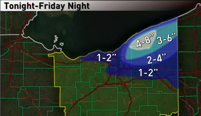
November 13-14, 2014 Lake Effect Event
The first of hopefully many this winter…and hopefully not my first ill-fated forecast.
Brief summary:
Tough forecast due to questions about snow band organization/location and due to marginal temps in lower elevations, especially closer to Lake Erie. However, good moisture and instability, combined with a disturbance moving by Thursday into Thursday night, suggest heavy snow showers at times where they occur. In general, I expect a band of snow to develop in the northern primary snowbelt Thursday morning and afternoon, mainly along and north of route 6 in extreme northeastern Cuyahoga, northern Geauga, Lake, and Ashtabula Counties. Snow rates in excess of 1” per hour may occur at times, and the snow will likely be wet, with graupel possibly mixed in at times. The question will be if this band can sustain and where exactly it’s located. I expect this band to possibly become disorganized by mid-afternoon as the winds begin shifting as a trough begins to move by. At this point, the band may swing farther south and eventually weaken. However, as it “swings” late Thursday afternoon and evening, it may produce a period of heavy snow and some quick accumulations along the way. For the rest of Thursday night I expect more disorganized snow showers to persist generally from Cuyahoga County eastward, with light additional accumulations. This general snow shower pattern likely continues into Friday. It is possible that another band develops Friday afternoon/evening as the winds begin to shift to a more westerly direction, and this band may produce moderate to heavy snow for a time Friday afternoon or evening from Cuyahoga County east. Again though, questions remain about where exactly this band forms and how organized it is. By Saturday morning, the lake effect should be shifting out over the lake. Hardest hit areas may see up to 8”, especially if one or both of these possible bands work out, with lesser elsewhere. In general, outside of where any bands occur, the snow showers may be briefly heavy but won’t be sustained, which should keep accumulations to a few inches or less outside of where these two possible bands occur.
Technical discussion:
This is a tough forecast for a few reasons…I believe there are a couple of time periods where decent bands may be possible, but how sustained these bands are and where exactly they occur will determine who sees the most accumulations, and how heavy they are.
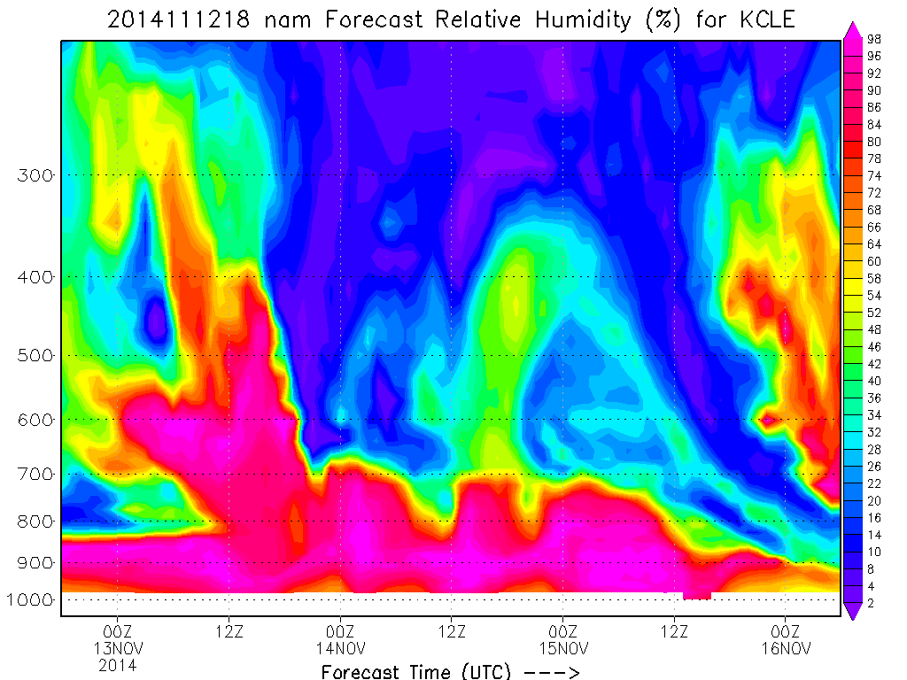
Overall, lake effect parameters become decent by Thursday morning. Lake induced instability will become moderate around 7AM and become extreme at times for Thursday through a good portion of Friday, with inversions rising to 10-11k feet by Thursday afternoon and remaining high through Friday. In addition, some synoptic moisture/lift will overspread the area Thursday morning, with moisture levels remaining mediocre to good through Friday evening. Here’s the NAM RH for CLE:
The big question is wind direction and possible band formation. I’ll throw up the NAM low level winds and go from there:
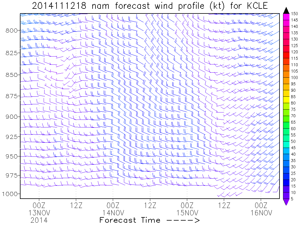
The winds begin to back a little bit during the morning on Thursday as a surface trough approaches from the northwest, and this coincides with when instability begins to become decent and when synoptic moisture/lift overspread the area. I believe the backing of the low level winds ahead of the surface trough will increase convergence enough over the central lakeshore and snowbelt to get a band to form around rush hour or just after, and conditions look favorable for it to become intense by late morning. The GFS never really shows a southerly component to the surface winds, but the NAM and most hi-res models do, and the Euro appears to as well for a time late Thursday morning into the afternoon. I’m inclined to believe the hi-res models and Euro here as they may do a better job of capturing the effects of the lake on the low level wind fields. This suggests that any band may line up in extreme northeastern Cuyahoga County, Lake, northern Geauga and Ashtabula Counties, possibly near or north of route 6. If the GFS winds verify, it may occur closer to 322, but I’m skeptical. If this band persists for a few hours, it may produce 2-4” beneath it just inland.
The winds then begin veering a bit towards evening as the surface trough goes by. This would cause any band to swing southwest and possible affect areas as far west as northern Lorain County and as far south as parts of northern Medina/Summit/Portage Counties. As the band swings, it may produce a quick burst of accumulating snows along its way. Lake effect parameters will be very favorable tomorrow evening, so if we do get a band swinging south, a quick 1-2” as it goes wouldn’t shock me. The hi-res models also suggest the strongest Lake Michigan connection during the evening hours, which further improves the chances for very intense snow squalls for a time, but with the band being on the move at this point I’m not sure how organized/long lasting they’ll be.
Uncertainty becomes pretty high Thursday night into Friday morning. Lake effect conditions will be very good and the winds will become very well aligned again, but I think the winds may take on too much of a northerly component to sustain a primary band. Some models show a real diminishing in the snow in this time frame which is possible, but I think that with a possible Lake Michigan connection continuing that at least scattered snow showers/a few squalls can continue overnight Thursday night into Friday morning, even if they aren’t very organized. This would probably produce another couple inches of accumulation inland for anyone affected. The winds will be well aligned so it’s not impossible that any band possibly re-stabilizes farther south across Cuyahoga County east into more of southern Geauga/northern Portage into Trumbull Counties, but I’m not really confident. It seems hard to get a band to re-establish immediately behind a trough when the winds take on a northerly component, especially when the wind shift happens pretty quickly. If the convergence hugs the lakeshore a bit longer then I suppose it’s possible. If this “best case scenario” happens, then a few inches may fall Thursday night into Friday morning across a good portion of Cuyahoga County (especially inland) points east. But, I’m currently leaning against this happening on a significant level, and am just expected light accumulations overnight Thursday night into Friday morning.
By Friday afternoon and evening, surface ridging begins moving in from the southwest and winds slowly back again. This often causes convergence to re-intensify just inland from Lake Erie, and may cause a band to redevelop across northern/eastern Cuyahoga County east into the snowbelt. As can be seen above, moisture doesn’t become too limited until after midnight Friday night, so if this band re-develops another couple or even few inches may occur. Things should begin winding down after midnight Friday night, and by Saturday morning most of the lake effect should shift out over the lake and towards western NY.
So, here’s what I did for accumulations: For the higher terrain in far southern Lake County into far northern Geauga County I figured 2-4” on Thursday under a band. Honestly, this has high bust potential either way, depending on where any band goes. With the snow rates I expect under any band on Thursday if it can develop, 2-4” isn’t unreasonable if any band persists for a few hours. If the band is closer to the lake, then more substantial accums may also occur in a narrow corridor under the band down to the lakeshore. Elsewhere, I figured a quick 1-2” Thursday evening as the surface trough passes and the band swings southwest and eventually weakens. If there is a good burst of snow showers as the trough passes, snow can probably accumulate a bit down to the shoreline. Since I’m betting against the band re-stabilizing overnight Thursday night into Friday, I didn’t add any more accums to southern Cuyahoga County, and figured an additional inch or two in the inland primary snowbelt Thursday night into Friday. This pushes totals to 2-4” for most of the primary snowbelt and 3-6” in the higher terrain in northern Geauga/far southern Lake County. For Friday afternoon and evening, I figured another 1-2” in eastern Cuyahoga County east into the primary snowbelt due to perhaps a last gasp as convergence increases due to high pressure building in from the southwest. This pushes most areas to their final totals on the map. Again though, it’s possible that this band over-performs and produces up to a few inches, or just doesn’t happen, which would cause the low end totals on the map to be more common than the high end total. I think these totals would be low if a more sustained band develops out of either “band potential”, so we’ll see. Banding prospects look very iffy IMO overnight Thursday night into Friday morning, but if a band occurs, then the southwestern portions would see higher accums as well.
Model breakdown:
12km NAM: Shows good banding both timeframes, widespread 0.5”+ QPF from eastern Cuyahoga east into the snowbelt. Also shows better QPF in southern/western Cuyahoga as it does hang on to more of a band Thursday night into Friday morning.
4km NAM: Similar to 12km NAM, slightly higher QPF in eastern Cuyahoga/western Geauga.
NMM: Shows good band in my highest accums area tomorrow, and a widespread 0.5-1” of QPF from eastern Cuyahoga County east.
ARW: Shows good band tomorrow, but slightly closer to lakeshore. 1-2” QPF in parts of Lake/Ashtabula Counties, generally 0.5”-1” QPF in the rest of the primary snowbelt. Shows a band hugging the western lakeshore Thursday evening, dropping around 0.5” QPF there.
BUF WRF’s: Slightly different ideas, but most of them like the band tomorrow morning in southern Lake/northern Geauga/possibly NE Cuyahoga east into Ashtabula, and some try to show intense snow showers (nothing too organized though) developing behind the trough passage by Thursday evening.
