
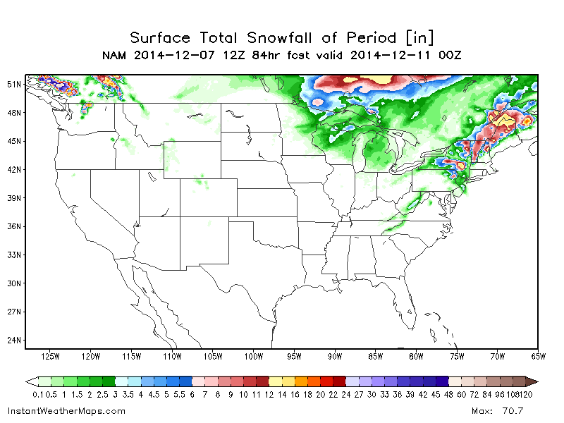
After a very cold second half of November across a large portion of the central and eastern US, December has come in a bit milder (although still near to below average, especially across the northern tier). A slow moving low pressure system off the East Coast Tuesday-Wednesday will produce heavy rain, damaging winds and coastal flooding to the I-95 cities from Richmond to Boston, with heavy, wet snow well inland. Higher elevations may see significant snow accumulations from this storm, mainly from Pennsylvania points northeast into parts of Upstate New York and New England:
After this storm system clears out for the weekend, an unfavorable weather pattern for cold/snow across much of the US outside of the mountains along the west coast will take hold, due to a deep Gulf of Alaska low flooding the country with Pacific air:
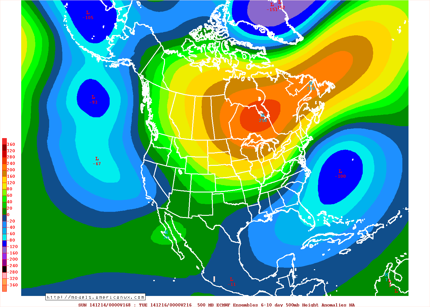
Note the expansive area of above average height anomalies across Canada on last night’s European ensembles in the day 6-10 timeframe, which suggests that arctic air will be locked up well north of the Canadian border around mid-month. Also note the generally low height anomalies from the southwest US east across the Gulf Coast states and off the East Coast, which does suggest an active sub-tropical jet. This means that the pattern won’t be dry across the southern US, but there won’t be much cold air to work with, meaning little snow after this week’s storm across the northeast.
BUT, times are a changing after mid-month, courtesy of the “MJO.” The MJO involves thunderstorms across the deep tropics. The location of these thunderstorms impacts where the jet stream is stronger, which strongly influences where troughs/ridges and hence colder/warmer air are more likely across the entire northern hemisphere. Recently, the MJO has been moving through phases 3, 4 and 5, and has recently moved into phase 6. The MJO has been expected to move into phase 7 after mid-month for a while now, and is still expected to do so:

As I labelled on the plot above, the MJO has been in the warm phases since late November, explaining the recent relaxation of the cold air. However, phase 7 is cooler and phase 8 is almost always cold in the central and eastern US. Note how this plot of temperature anomalies with each MJO phase for early December matches the recent pattern evolution fairly well, with temperatures gradually warming as the MJO goes through phases 4-5 and becoming the warmest in phase 6, which our models show happening late this week into next weekend:

The weather the past week hasn’t been particularly warm due to the cold air in Canada being slow to scour out, however the overall pattern evolution has matched pretty well (note the cooler weather near the West Coast, which correlates to the recent increase in storminess there). Also note how MJO phases 7-8 correlate to colder air building back into the central US and trickling into the eastern US. This suggest cooler air returning to the east at some point after mid-December.
The MJO stuff is all fine and dandy, however recent runs of our forecast models are also trending the way of a cooler weather pattern returning after mid-month:
GFS ensembles:
GGEM ensembles:

And, although I can’t post the Euro ensembles because they’re behind a paywall, the Euro ensembles also show a similar pattern two weeks out.
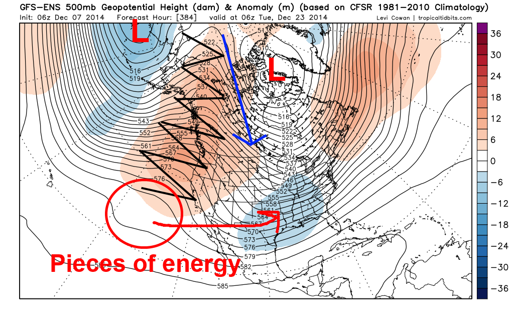
This pattern would be highly interesting from the Plains east through the Ohio/Tennessee Valleys, eastern Great Lakes and into New England and the northern Mid Atlantic. The Gulf of Alaska low that will develop this week as discussed above is shown to “retrograde” to the west towards the Bearing Sea/Aleutian Islands, which pumps up a +PNA and –EPO ridge over western North America. This allows either a flow from the Arctic Circle or per the GGEM and Euro ensembles a “cross polar” flow to develop, which allows cold air to return to Canada during the third week of December, after it gets blasted away next week. Although the NAO is either neutral or positive, the ridging over the western coast of the continent allows this cold air to begin getting into the central US by around the 20th per current modelling. In addition, there are hints of the active sub-tropical jet stream discussed above continuing through the rest of the month, which may mean an active storm track continuing across the south-central and then eastern US through the remainder of the month, with cold air coming into play by the last week of the month.
So, with all this said, what do I think will happen with the weather pattern?
-For this week, temperatures will warm to above average across much of the central US, with near to below average temps across the east with snow in the interior Mid Atlantic and New England. The west will be near average in the temp department overall with increased precipitation (rain/mountain snow).
-For December 15-22, temperatures will be near to above average across the central and eastern US, and warm to above average along the west coast as the +PNA begins to build. The northern portions of the US may begin to see cooler air return in this timeframe per the MJO progression and current model ensemble guidance, however, Canada will take some time to cool back off once the +PNA/-EPO begins to develop and models have been known to rush pattern shifts before, so I’m going to stick with average to above average temps still in the central US for this week.
-For the end of December into the New Year, if this pattern change occurs as I believe it will, temperatures will likely be below average in the central US into the Great Lakes and New England. With no –NAO and cold appearing to dive into the central US, a southeastern ridge may persist, which would keep the lower Mid Atlantic and Southeast warmer. This pattern may favor snows from the Plains east through the Ohio/Tennessee Valleys, southern and eastern Great Lakes, New England, and the interior and northern Mid Atlantic.
This pattern change isn’t a certainty, however the MJO has been modelled to progress through unfavorable phases and cause a warmer start to December and then become more favorable after mid-month for a while now, and that looks to happen as the thunderstorms in the Indian Ocean have propagated east into the western Pacific recently. The models are picking up on this as the ensembles have been showing a corresponding pattern change by late in the month for several runs now. We’ll see if the change occurs before Christmas like the models show or is closer to New Year’s…either way, the potential for colder and snowier weather to return to parts of the central and northeast US around the holidays appears to definitely be on the table.
