
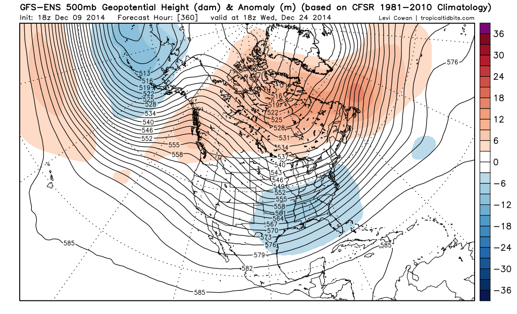
Perhaps I’m just too optimistic, but I don’t totally hate the weather pattern shown on all three ensembles moving forward, and I think there are a couple chances to thread the needle with some snow somewhere in the Ohio/Tennessee Valleys east into parts of the Appalachians/Mid-Atlantic even before I think the pattern starts improving for cold towards Christmas and into January. Where the best snow chances end up, if any materialize, will be ironed out in the coming week or so.
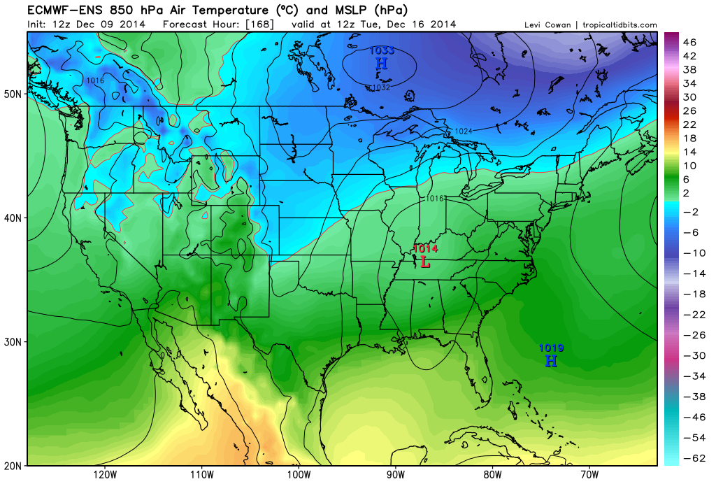
The first potential system to track is next Tuesday-Wednesday. The GFS, Euro and Canadian both show a decent sub-tropical jet (STJ) shortwave ejecting into the Plains on Monday. The GFS and Canadian appear to show decent northern stream involvement and show a low tracking into the Great Lakes with a swath of accumulating snow on the northwestern end of it, with some wrap around snow showers behind it for a good chunk of the Great Lakes and upper Ohio Valley. The Euro shows almost no northern stream involvement and no snow, although some of its ensembles appear a bit more optimistic. The ensemble mean shows a low tracking across the Ohio Valley, although there appears to be a lot of spread among the ensemble members. Temps appear too warm ahead of the system, so we’d need northern stream involvement to see any notable snows. It’s not impossible though as the models appear to show a northern stream shortwave tracking across the Upper Midwest/Great Lakes in this timeframe:
The next opportunity appears to come around the 20th. All three ensembles at 12z show another STJ shortwave ejecting into the Plains around the 19th and tracking east across the Ohio Valley thereafter. The northern stream shortwave shown to move across the Midwest/Great Lakes around the middle of next week could pull down some cold air ahead of this next STJ shortwave, however again, northern stream involvement looks iffy for the threat around the 20th, which may limit how large of an area possibly sees snow.
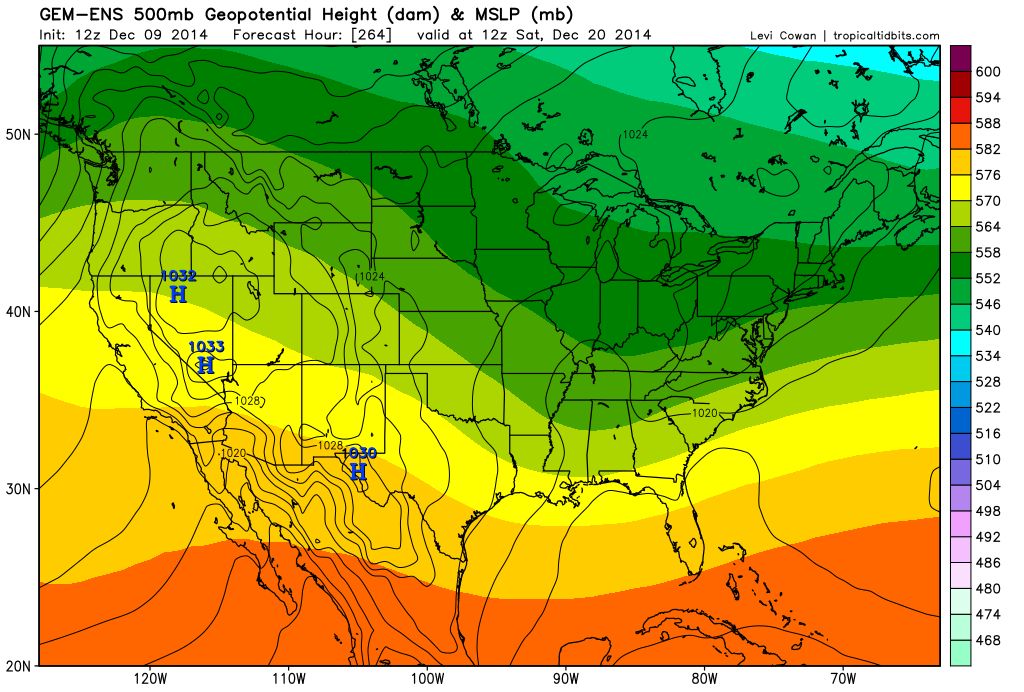
The Canadian and Euro ensembles show an ok surface reflection for this far out in the ensemble means, with an inverted trough moving across the Ohio Valley the 20th-21st. The GFS ensembles show this feature staying much farther south. If the day 10+ Euro ensembles were available on a free source I’d post them instead, but the GGEM ensembles around the 20th look reasonably close to the Euro ensembles at the surface and if anything slightly less amplified at 500mb:
The Euro ensembles if anything are slightly lower with surface pressures and show the shortwave taking on a modest negative tilt before hitting the Appalachians. The Euro ensembles show the 0C line at 850mb a bit north of the Ohio River as this system goes by, which is better than what’s shown with next week’s system, so I’d have to imagine that if there’s any northern stream involvement that this one could be somewhat interesting. There’s modest confluence over the northeast which would probably keep this one from going too far north even if there was some phasing. The GGEM ensembles do show an increase in precipitation into the lower Great Lakes as this wave goes by:

Both ensembles appear to show a slightly better look for the East Coast, but this may become something to track across the upper Ohio Valley/lower Great Lakes. I’d say the key for this one is also some northern stream involvement and getting a little bit of cold pulled down behind next week’s system.
For what it’s worth, we can look at the Euro ensembles a day or two before this possible system to watch:

It would probably be better if the ridge over the western US was located a little bit farther west, but that isn’t the worst look for some snow across the areas I outlined above, and that is a nice piece of energy ejecting into the Plains. There is some chance for northern stream involvement, but I’d like to see the western US ridge slightly sharper and perhaps a bit farther west to feel more confident.
After the potential system around the 20th, the pattern looks to stay active and looks to improve for those of us who’d like cold weather. The changes start in the Pacific, and you can see the change within a week on the GFS. The Euro still seems to like the MJO going through phase 7 (although at a weak amplitude) before going into the COD for most of the next two weeks:

The GFS reflects a more favorable Pacific jet, probably because the most active convection isn’t well west of the Dateline and over the Indian Ocean like it had been. The GFS and it appears the Euro ensembles also appear to quiet down the convection near Hawaii a little bit in the mid-range as well, which weakens the Pac jet closer to the west coast of the US as well (which is good if we want to build a ridge there).
Anyways, here’s what the Pac jet currently looks like per the GFS:
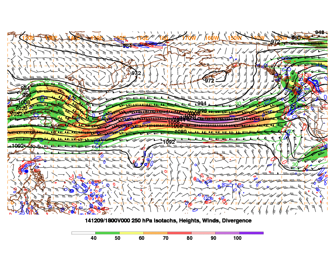
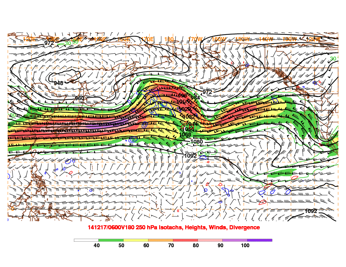
At 180 hours, the strongest of the jet is focused over eastern Asia and into the western Pacific, with favorable divergence over the NW Pacific, supporting storminess near the Aleutian Islands or just west, which does support a ridge developing along the West Coast thereafter:
We’ll see how things evolve. The long range GFS has tried a couple of times to flirt with a very amplified western US ridge near the end of the run, but that is fantasy range stuff. Looking at the Pac jet at 180 hours is more reliable, so we’ll see if the improvement in the location of the strongest portion of it holds up on guidance over the next few days or so.
If the improvement in the Pacific is real (the ensembles have suggested it for several days, and the MJO supports it too), then we’d likely see better chances at northern stream involvement with any STJ moisture that ejects into the Plains during the last 7-10 days of the month. The ensembles do all suggest another piece of energy ejecting a couple of days before Christmas and one possibly around Christmas, but that’s pretty far out to get too specific.
As to where the more active weather pattern may impact during the latter portions of the month, it may ultimately depend on how much the western US ridge amplifies. If it’s flatter, I’d say farther east would be favored, even with no real –NAO showing up for the next two weeks, as there probably wouldn’t be any opportunity to phase over the Plains like we’d need. If it’s sharper, we’d probably see northern stream shortwaves dive into the Plains, and with no –NAO, if they have some STJ energy to phase with (which looks quite possible), then they may cut farther NW, which would be good for a lot of this sub-forum. So, I do think we may have some chances late in the month.
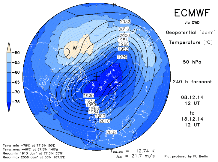
As for heading into January, we’ll see. Some of the longer range MJO plots try to suggest the MJO might become a bit more unfavorable, however for now it doesn’t look to be quite the amplitude it was over the last couple of weeks. In addition, the GFS and Euro have both been hinting at some good warming in the lower portions of the stratosphere (100-50mb) during the latter third of December for a few runs now, with some signs of the vortex becoming disturbed. If that persists, that could correlate to a more –AO heading into January. If western N. America ridging does in fact develop over the last third of the month like the ensembles are currently insisting on, this could allow for a much colder weather pattern to develop at some point between January 1 and 10. We’ll see:
Anyways, a lot of this is speculative, as a lot of long range stuff is. But, with an active STJ, I think we’ll have our chances during the last third of the month, with the more optimal chances probably coming closer to the last week of the month as we get more northern stream involvement. It may come down to when individual shortwaves phase to determine where the best threat for snow ends up (IE here or closer to the East Coast), and that’s obviously a crap shoot this far out. Early indications look like a pretty cold start to January, but we’ll have to watch how the Pacific pattern and possible stratospheric warming play out over the next couple of weeks.
