
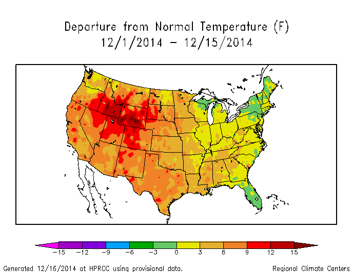
With the exception of parts of the Upper Great Lakes and Northeast, much of the country has “enjoyed” warmer than average temperatures to start December. This was mainly caused by a very strong Pacific jet stream overwhelming the cold air across much of the continent, outside of Alaska. This will begin to change, with 3 defined chances for storms over the next 10-14 days, and below normal temperatures likely returning to a good portion of the central and eastern US.
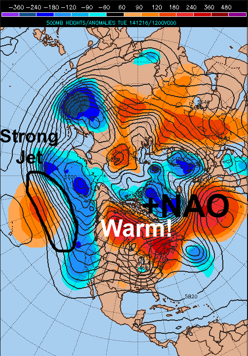
The current weather pattern across the Northern Hemisphere still isn’t a good one for cold/snow across the central and eastern US. Canada is very warm compared to normal, with a stronger than normal Pacific Jet making it hard for ridging to build across the western portions of the continent. This means that currently, we are having trouble getting truly cold air to dip into the country, and this also means that the “polar branch” of the jet stream is weak and having trough making inroads into the US. This makes it difficult to see snowstorms, and will be an issue this weekend for our first possible “storm threat” across the eastern US.
Here is a look at the Pacific jet as analyzed by this morning’s GFS model. Note how the jet is fairly strong and also oriented west-east up until hitting the west coast of the US, when it then “breaks”, which supports ridging (warmer/drier conditions) over the central/eastern US:

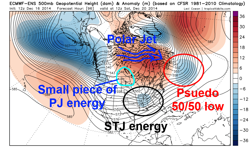
As we move the model forward to Sunday afternoon, the Pacific jet has a bit of a different look. Note how the jet breaks over the NW Pacific and “fans out”…this is known as upper level divergence, which supports storminess in the northwestern Pacific, which would favor ridging developing into Alaska next week and possibly beyond (known as a –EPO). Also note how there’s a ridge off of the US west coast (+PNA), which supports a trough developing in the central US next week:
This type of orientation would support true cold air returning to Canada starting next week, and would support that cold coming into the US (centered in the central US). Also, note the features south of the main jet stream over the eastern Pacific; these are disturbances in the sub-tropical jet, which bring moisture laden disturbances into the southwestern US and points east. The combination of colder air making inroads into the US with a more active polar branch of the jet stream, along with an active sub-tropical jet would support storminess next week and beyond, with someone likely seeing decent amounts of snow.
Threat 1: This Weekend:
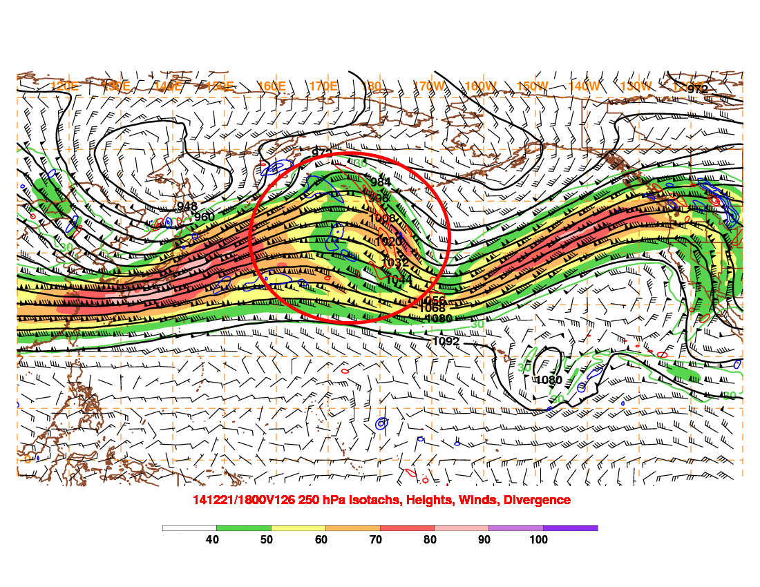
The first potential for a snow-maker to impact parts of the central and eastern US will be this weekend as a piece of sub-tropical jet energy ejects out of the southwestern US and tries to interact with the polar branch of the jet stream over the central or eastern US:
This isn’t a good setup for a large snow storm. The bulk of the polar jet is going around a poor man’s “omega block” (note how the pattern over the NE US and SE Canada tries to resemble the Greek letter omega), which limits how much it can interact with our piece of moisture laden sub-tropical jet energy riding across the southern US. What this system does have goes for it is a trough close to 50N, 50W that kind of acts like a 50/50 low and causes surface high pressure over the Great Lakes and New England, which does give any storm that does occur a little bit of cold air to work with. The sub-tropical jet energy is taking on a negative tilt west of the Appalachians, which suggests that any snow would be favored to occur over the Ohio Valley, Appalachians, New England and interior Mid-Atlantic. There is a small piece of energy that breaks off from the Polar Jet and moves in the central US, and if these two pieces of energy combine or “phase,” then this disturbance may produce light to moderate amounts of snow in the areas discussed above.
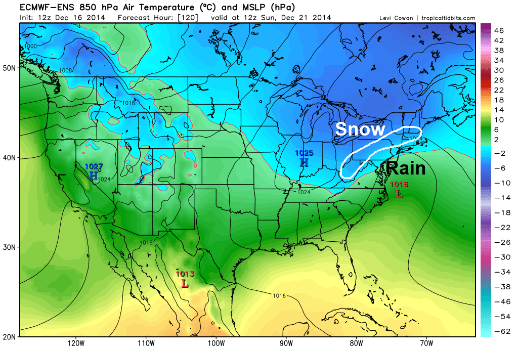
The European ensembles do show a hit of a weak storm off the East Coast on Sunday morning, with temperatures cold enough for snow in the interior, with a mix or rain closer to the coast. This could turn into a few inches of snow here and there in mainly the Appalachians and interior Mid Atlantic, with the upper Ohio Valley and New England possibly seeing some snow if the “phase” discussed above occurs early enough.
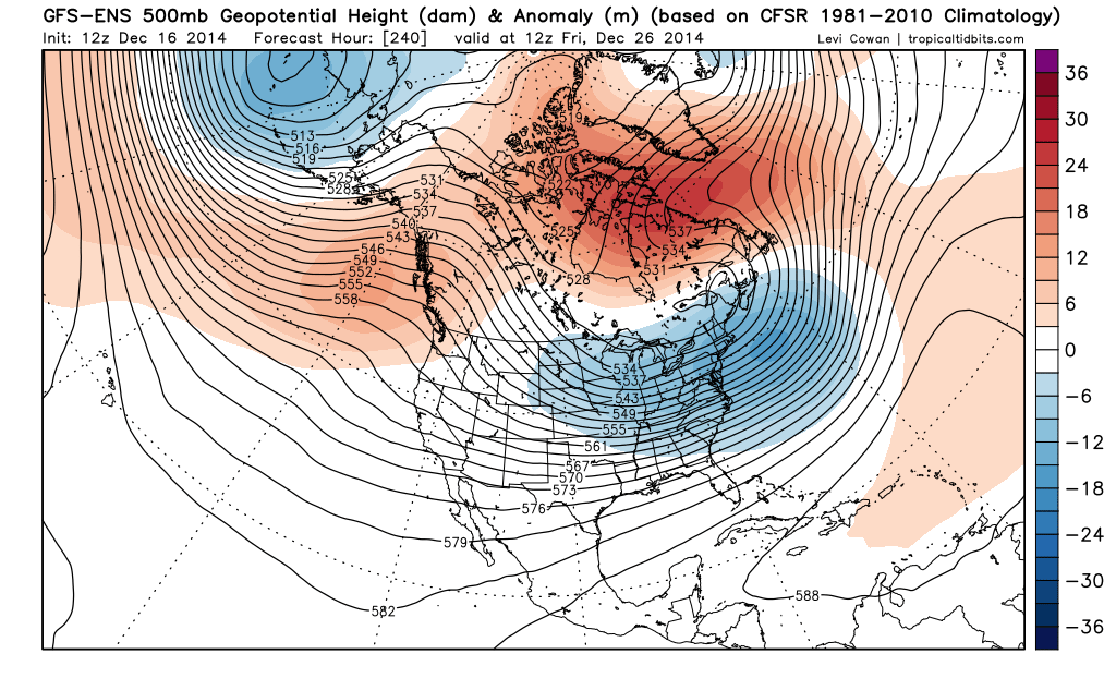
Threat 2: December 24-26th:
The time period of this “threat” will surely get the weather weenies excited across the Internet over the coming days, as snow on Christmas Day is a dream come true for many of them. By this point, the pattern change discussed at the beginning of the article will be full blown, with a much more amplified trough over the central US. The main question is, will the NAO go negative and allow for any storm to possibly transfer to the East Coast and give parts of the eastern US snow for Christmas?
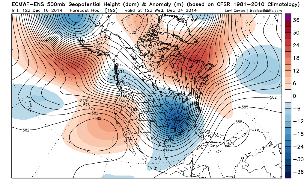
The European ensemble mean valid next Wednesday morning show a beautiful trough across the central US, with the trough taking on a negative tilt over the western Great Lakes and along the Mississippi River. This is too far west for a good East Coast snowstorm, by a long shot. There is some ridging over the western US (+PNA), however there is no 50/50 low and no –NAO on the Euro ensembles. As is, the Euro ensembles would suggest the possibility of a snow storm across parts of the Plains, Midwest and Great Lakes, with a possible transfer of energy to off the New England coast with some snow in New England, as the Euro ensembles do show the very potent trough swinging east to New England by Christmas Day. The Euro ensemble solution also would suggest some potentially heavy lake effect snow in the Great Lakes Snowbelts:
The GFS ensembles paint a slightly different picture this afternoon for the potential “Christmas Storm”…the GFS ensembles do develop a bit more of a –NAO ahead of the storm, and while they do show the trough taking on a negative tilt west of the Appalachians, they are farther east with the whole storm, which would possibly suggest good snows across the interior Northeast and Appalachians:
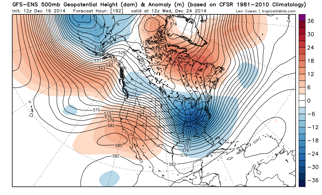
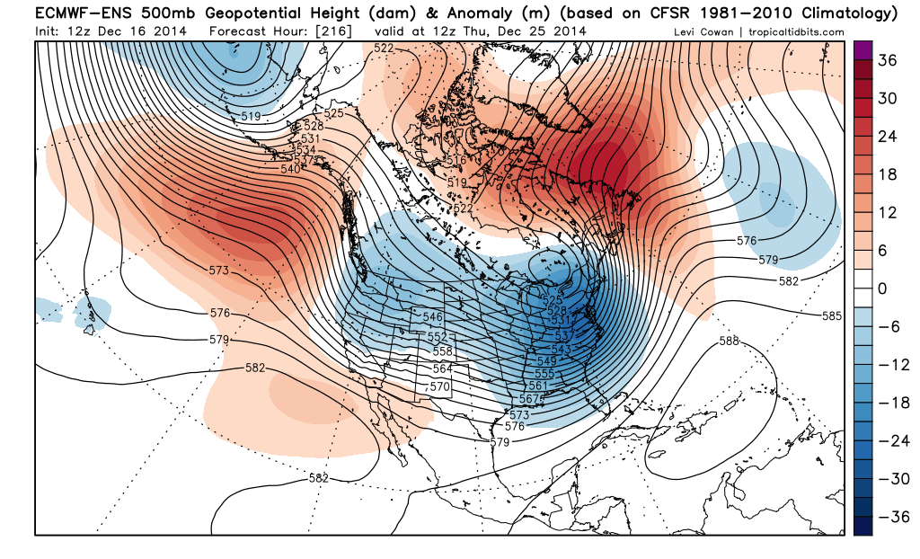
Note how the GFS ensemble mean shows positive height anomalies (reds) over extreme eastern Canada into the Davis Straight, with a small area of low height anomalies (blues) just southeast of Newfoundland. In addition, it shows the trough taking on a negative tilt closer to the Appalachians than the Euro ensembles. The GFS ensembles show slightly weaker ridging on the West Coast, but is similar in that area in principle as the Euro ensembles. The next frame of the GFS ensemble mean would be interesting for the northern Appalachians, interior New England and possibly the eastern Great Lakes for Christmas Day:
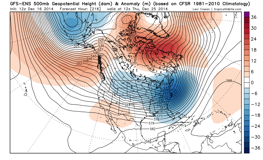
The trough has taken on an extremely negative tilt by this point with the –NAO intensifying a bit, suggesting any storm would max out and slow down over New England, with heavy snow and strong winds likely on the western side of it.
So, the debate becomes, which solution is more correct (Midwest/Great Lakes storm per the Euro ensembles vs an interior Northeast/Appalachians/eastern Great Lakes storm per the GFS ensembles)?
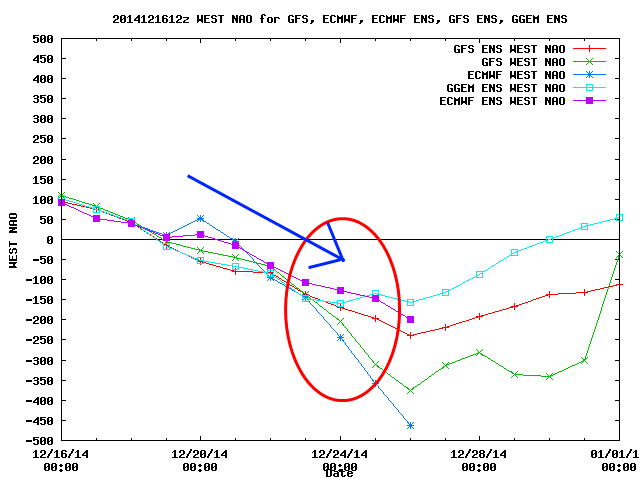
A look at what the GFS, GFS ensembles, Euro, Euro Ensembles and Canadian ensembles do with the “west based NAO” (a –NAO centered near Iceland or the UK won’t flip this index negative, but a block near Greenland or eastern Canada will) over the next 10-14 days reveals that the GFS and Euro ensembles show a very similar decrease in the NAO over the next week, with the GFS ensembles showing just a slightly quicker building of the –NAO as pictured above. When looking at both of the ensembles side by side Monday morning, you can see where the differences start to develop:
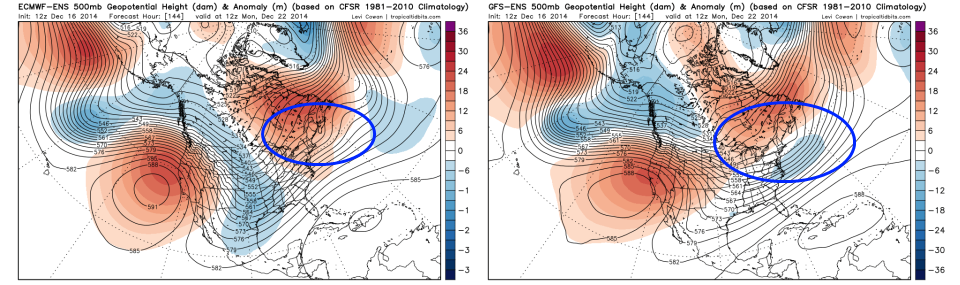
Note how the Euro ensembles on the left show this weekend’s system pulling out much quicker, and don’t leave negative height anomalies just off the East Coast like the GFS ensembles on the right show. The GFS ensembles are a little slower to dig the trough over the central US to start next week, but catch up to the Euro in that department by Tuesday. The handling in this weekend’s “storm” over the eastern US appears to influence the possible –NAO for the system next Wednesday and Thursday.
At this point I’d favor possible decent snows and winds over parts of the Midwest, Great Lakes, northern Appalachians and western New England around next Wednesday and Thursday, however, we probably won’t know with high confidence who may see the heaviest snow from the possible “Christmas Storm” until the solution for this weekend’s storm has been worked out first.
Threat 3: December 27-30th:
The active subtropical jet with cold coming into the US means storm threats will be frequent. Not every threat may pan out in the shorter term, but the possibilities will be there. The Euro ensembles show an extremely impressive map for day 10:
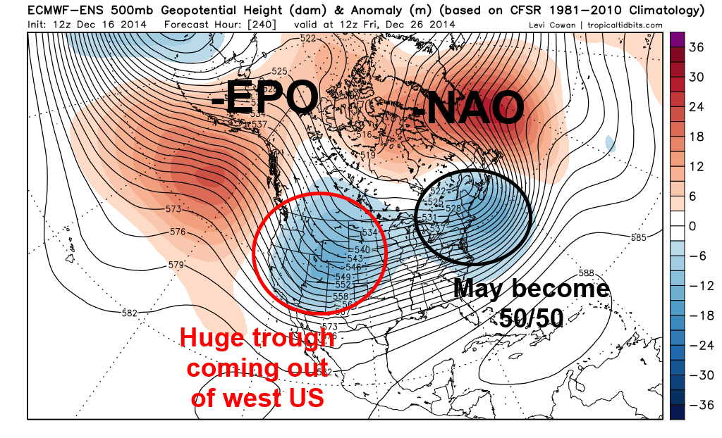
This pattern would be good for a widespread and significant winter storm in the days after Christmas. A –NAO has clearly intensified and is in nearly perfect position for the East Coast, with the “Christmas Storm” moving to the northeast and likely getting ready to turn into a 50/50 low. The only rub here for the East Coast is that there isn’t really a western US ridge, it’s focused off the West Coast and into Alaska (which counts as a –EPO). Ridging in this location causes cold and troughs to be focused over the western and central US.
However, the –EPO suggests cold air will be coming into the US (with a possible cross polar flow into Canada allowing truly arctic air to possibly become involved at some point at the end of December or into early January), and the –NAO and 50/50 low combination suggests that even if storms get really strong over the Mississippi Valley/Great Lakes, that they may transfer to the East Coast. A piece of energy this strong moving out of the western US would pose a risk for widespread snow and possibly ice across the Plains, Midwest, Great Lakes and then possibly New England, the Mid-Atlantic and Appalachians if the –NAO and 50/50 low could cause any storm to eventually transfer its energy to the East Coast.
The GFS ensemble mean valid at the same time shows the same –NAO and possible developing 50/50 low, but is a little farther east with the ridging on the West Coast, and showing the trough that will possibly cause the “post-Christmas storm” developing over the Midwest, as opposed to the Rockies. The GFS ensemble pattern would suggest more of a pure East Coast storm threat, as opposed to a possible Midwest/Great Lakes storm followed by a transfer to the East Coast.
Which one is ultimately correct is unknown. Both models show a similar –NAO by this point, with the differences lying in the Pacific pattern. At this point, the Euro ensembles have been pretty consistent in hinting at a Midwest/Great Lakes snow threat before a possible transfer to the East Coast in the December 27-30 timeframe while the GFS ensembles have been jumping around a bit more. It is tough to call which solution is favored, but I’ll watch trends in the coming days and post updates as I can.
Moving Forward:
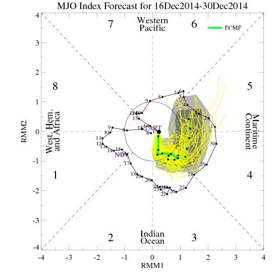
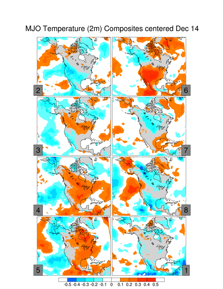
The MJO (which describes where thunderstorms in the tropics are located) is modeled by the European ensembles (above) to emerge into phases 3-5 for the last week of December, before possibly moving towards phases 6-7 thereafter. As you can see on the plot above, the MJO moved through similar phases at the end of November and beginning of December, which eventually resulting in our recent mild weather pattern. Here is what each MJO phase correlates to temperature wise across the continent:
If the MJO emerged into phases 3-5 as the Euro currently expects, this would suggest a possible warming trend for a brief time in early January. The GFS ensemble teleconnection plots also appear to show the potential for the cold to back off a little bit just after the New Year:

Note how some GFS ensemble members begin showing an increasing trend in the AO/NAO at the end of the run, which would suggest the pattern not being as conducive for cold over the central and eastern US. However, the PNA does remain positive, which would suggest that a “blow torch” wouldn’t be likely.
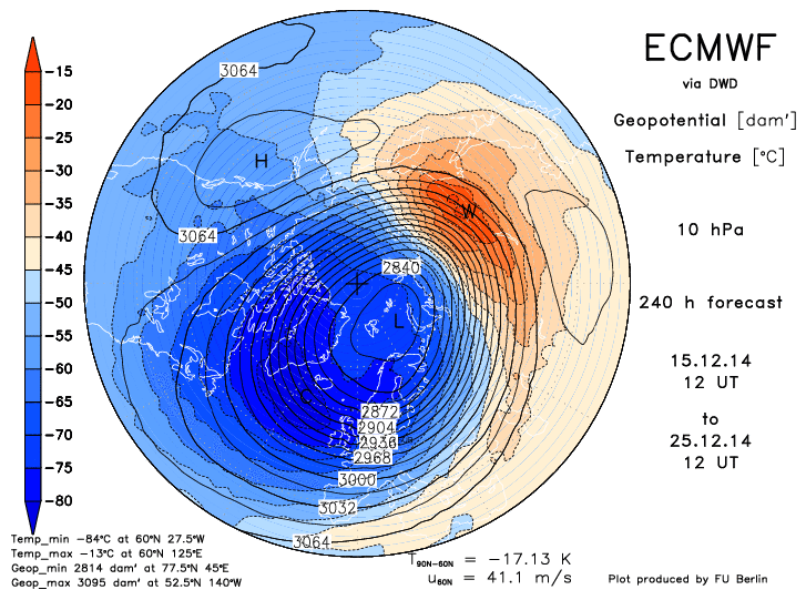
Another factor to watch going forward will be the potential for a stratospheric warming event with the potential for an eventual stratospheric vortex split. The Euro and GFS (Euro pictured above) both suggest a pretty significant warming event occurring in the stratosphere within the next 7-10 days, with some GFS runs even splitting the vortex within 14 days. This would potentially suggest potent –AO and –NAO blocking developing by mid-January, with cold and snowy weather likely across the central and eastern US. This warming and potential splitting of the stratospheric vortex, if it occurred, would occur in line with how other high snow cover advance Octobers played out in the following winters.
Summing it Up:
There are three distinct chances for snow makers over the next two weeks. One this weekend, which looks to be a mainly light to at worst moderate event. One around Christmas, which may favor the heaviest snows over parts of the Midwest, Great Lakes, and interior New England, with possible lake effect snows on the backside of that system. Another around December 27-30, which could be a pretty legimiate threat for a wide stretch of real-estate across the central and eastern US, depending on how exactly the pattern plays out. Things will change with the latter two threats, so stay tuned for further updates.
The coldest temperature anomalies may arrive in the central and eastern US behind the December 27-30th storm threat, with perhaps a slight warming during the first 7-10 days of January, with the potential for very cold and potentially stormy weather to return by mid-January depending on how the MJO and stratospheric warming play out over the next few weeks.
Lots to track, so stay tuned!
-Jim Sullivan
