Several model images in this post are from Tropicaltidbits.com. Any drawing on the images is my artwork. Visit Tropicaltidbits.com for great information including forecast model images such as those used here.
The “pattern change” that will hopefully lead to a setup more conducive for snow that has been talked about for weeks is finally occurring…however, the pattern still isn’t very good, and snow has not been very widespread over the last few days and won’t be very widespread this week across the central or eastern US.
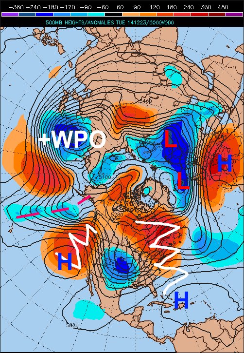
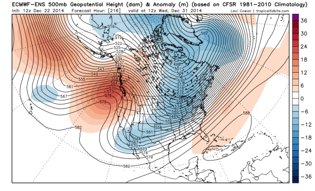
Ridging is finally developing along the West Coast as per the image above, however, the ridge isn’t very “tall” and is allowing a strong Pacific jet and shortwaves in that jet to crash into the NW US from the west. This is limiting how much cold air can build into the central and eastern US this week. This is also limiting how much cold air can build into Canada this week. In addition, the NAO still isn’t really negative. Note how there are low height anomalies over Greenland, Iceland, and really most of the far northern Atlantic Ocean, with positive height anomalies to the south. This if anything is more of a +NAO pattern, with pretty good ridging from just off the SE US coast into eastern Canada.
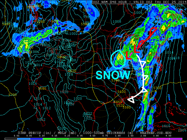
A deep trough has still developed over the central US, and a low pressure system will develop along the Gulf Coast on Tuesday and track into the western Great Lakes while becoming fairly deep. There is pretty good agreement on a low track somewhere between Chicago, IL and Sandusky, OH, which may produce a swath of accumulating snows from parts of Illinois north-northeast into parts of Wisconsin, eastern Iowa, and northwestern Michigan.
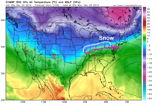
A look at the Monday evening run of the NAM model shows this scenario well. The NAM has struggled in handling this system, but finally looks pretty close to the developing model consensus. The trough being centered over the Plains in the first image of the post, combined with a SE ridge and no –NAO is what will cause the low pressure system to track north-northeast from the Gulf Coast to the central or western Great Lakes on Wednesday into Wednesday night. There looks to be a narrow but fairly intense zone of snowfall on the western side of this low pressure, which may bring several inches of snow to Chicago on Christmas Eve, which will surely impact air-travel across the region. Much of the eastern US will be unseasonably warm in the southerly flow ahead of this low pressure, and some severe weather will occur across the Deep South Tuesday into early Wednesday along the cold front trailing this storm system.
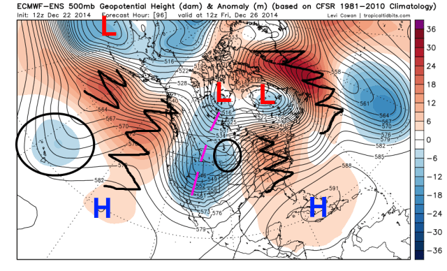
Unfortunately, the lack of true cold air over Canada and the lack of amplitude to the ridging on the West Coast, which will allow our next system (called a shortwave) to move into the NW US, will mean that the cold air pulled in behind this system will be relatively meager. In addition, as can be seen on the European Ensembles valid Friday morning, the “Christmas Eve Storm” won’t become a 50/50 low. So, while the pattern will gradually continue improving this week for cold and storminess in the central and eastern US, it still won’t be good for the eastern US heading into this weekend:
Note how by this point, the NAO is attempting to go negative, with a ridge extending towards Greenland. However, the ridge is more of a thumb ridge, and it’s still too west to really help the eastern US by this point, hence the “SE ridge” still being present on this image. The ridging over the NE Pacific and over the West Coast is getting “better,” with the jet stream forced north towards Alaska, but still isn’t sharp enough or far enough east for the eastern US. There is improved cold air over Canada however, as a bit of a PV anomaly (the low west of Hudson Bay) has dropped into the area, and as the Pacific jet isn’t blasting in as strongly.
A deep trough will be swinging out of the Rockies this weekend and into early next week. With a lack of better positioning of the western US ridging, a SE ridge, and a marginal NAO, this deep trough will likely not result in significant snows for the eastern US (except for New England). However, the cold beginning to build in from Canada running into the SE ridge will setup a strengthening thermal gradient from the southern Plains east into the Ohio Valley and New England, and with energy moving out of the west (with more moving in, note the circled feature near Hawaii), this setup does seem conducive to snow/ice along the thermal gradient described above.
Threat 1: Thursday-Friday (December 25-26):
This is the featured circled on the above European Ensemble map across the Plains. This is the first piece of energy that will eject out of the western US trough along the developing thermal gradient. The SE ridge will be pretty stout, which will allow this system to track into the Midwest and northern Great Lakes:
Looking at the European Ensembles at the lower levels for Friday morning, you can see a low pressure across Iowa with an area of snow across the High Plains and into the Upper Midwest, with a large SE ridge in place, with a large area of south-southwesterly winds from the southern Plains east into the lower Great Lakes, which will allow more mild air to move in to much of the eastern US ahead of this “storm.” There is decent model agreement on a potentially significant snowstorm across parts of the Rockies for Christmas Eve and Christmas Eve, with a swath of moderate snow and possibly winds across parts of the upper Plains/Midwest.
The bigger purpose this storm may server will be to help pull in a bit more cold air behind it and shift the developing thermal gradient to the south. You can see a fair amount of cold air available just north of the Canadian border, which as I discussed above looks to be in place moreso by the end of this week than right now, which bodes well going forward.
Threats 2/3 (December 27-30):
I have lumped these two “threats” into one section since our models are trying to key on two shortwaves ejecting out of the western US a day or so apart in this timeframe.
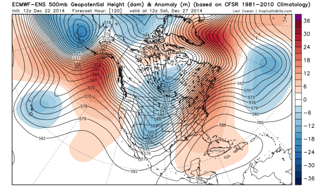
The European ensembles from Monday afternoon valid Saturday the 27th show a pattern beginning to become more conducive to snows, although most of the eastern US still isn’t “sitting pretty” yet…the NAO is modestly negative, and ridging is beginning to build into Alaska, with a piece of the polar vortex sitting over Hudson Bay. However, the mean trough is still over the Plains with a southeast ridge. This suggests that cold would continue building into Canada and the central US this weekend, with milder air still holding on across the eastern US.
There is a notable “shortwave” in the mean trough over New Mexico in the image above, getting ready to eject out into the Plains. With cold air oozing in from the north and warmth still stubborn across the SE US, there should be a decent thermal gradient across the country from the southern Plains into the Ohio Valley and northern New England this weekend, which is likely where any storm system Saturday into early Sunday would ride up along.
Out of this evening’s models, the Canadian is the only one that shows much of a first “wave” Saturday into Sunday. It would produce some light snow across parts of the upper Ohio Valley, southern and eastern Great Lakes and into far northern New England. I think if anything the Canadian might be a little bit too aggressive in moving in the cold for this “threat” for the first half of the weekend, meaning it might show snow a bit too far southeast.
We’ll see if any future model runs pick up on this potential wave of low pressure riding along the thermal gradient Saturday into early Sunday, as there are signs of a half decent shortwave ejecting out of the Rockies on Friday per the Euro ensembles above.
Moving the Euro ensembles ahead to next Monday morning, the pattern is starting to look better for snow farther southeast, with more energy moving out of the west. The ridging has become very amplified along the west coast and into Alaska and NW Canada, with a portion of the polar vortex still rooted near Hudson Bay. This would allow for Canada to be cold, and that cold would come into the central and northern US in this pattern. This really suppresses the southeast ridge. The NAO isn’t really negative, and this pattern has the look of fast moving storms.
The 0z Euro and GFS both liked a potential storm with this possible second shortwave ejecting out of the Rockies, with possible impacts in the central US between December 28 and 30:
Euro:
Parallel GFS (this will be the “operational GFS” at some point soon):
When looking at the Euro ensemble images above, a few things look more favorable for this storm threat than any of the other ones this month. First off, strong west coast ridging is driving the polar branch of the jet stream well south into the US, which would possibly allow for better phasing with moisture laden sub-tropical jet shortwaves. In addition, the ensembles are trying to key on some decent confluence over SE Canada and New England, which would support a farther south storm track.
At this point, the models are all over the place with which of these two waves possibly develops, and where they track, but IF the first wave develops on Saturday, I’d favor a more northwest solution with any snow confined to a stripe from the central Plains into the lower Great Lakes and perhaps far northern New England. The second wave may be a few hundred miles farther south than that.
The recent trend has been for storms to end up weaker/less amplified and also warmer overall than projected by the mid-range models, and with no –NAO any storms would be fast moving. However, the western N. American ridging is much more impressive in this timeframe, which may allow for the more amplified solutions to play out with one of these two waves.
Threat 4 (December 31-January 2):
Some recent runs of the operations GFS, Euro and Canadian have hinted at another shortwave and associated surface low pressure riding along the thermal gradient from the southern Plains east through the Ohio Valley and Mid-Atlantic around the New Year. By this point, the western US ridging is beginning to diminish on the Euro ensembles, but the trough axis is expected by the ensembles to shift a good bit farther east. This COULD result in this wave of low pressure, if it occurs, being the farthest south. The NAO is still positive in this timeframe, so any system would be fast moving and likely positively tilted. I want to see how the next several shortwaves moving out of the west evolve and how the western US ridging looks to hold up before making any kind of concrete guess on this threat.
How cold will we get in the central US to end the year, possible warm-up to start the New Year, and moving forward:
The weather pattern this month has been extremely frustrating at times…I feel as though I’ve gotten some aspects of it right, but missed some smaller details. We warmed up for the first half of the month as expected, although cold air was slow to scour out of Canada, which kept a good portion of the Great Lakes and Northeast pretty close to normal temperature wise for the first half of the month. This pattern change is occurring when it was supposed to, however the Pacific jet stream has been a bit stronger than anticipated which has made ridging over western N. America slower to develop, which makes it harder for Canada to reload with cold air and also makes it harder for deeper storms to occur, as this results in a more anemic polar-branch of the jet stream. This can be seen by storm threats around December 20th trending from a potentially large moderate swath of snow to what ending up being nothing, and by the Christmas Eve storm trending from a sub 970mb bomb over the Great Lakes to a more pedestrian 980mb-990mb storm over the region. In addition, the cold air behind the Christmas Eve storm will not be as impressive as progged a few days ago, which has ramifications for future storm threats.
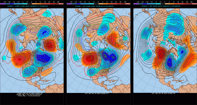
When trying to figure out how cold we may get near the New Year or perhaps just before, the models vary in how strong they get the ridging over the Alaska and NW Canada (-EPO ridge). The GFS and Euro are pretty similar and show a ridge strong enough to tap some cold air from the north-pole, with a decent chunk of the polar vortex sitting over NE Canada, with perhaps an east based –NAO. The Canadian (far right) is much more amplified with the –EPO, and farther south with the polar vortex. The Canadian would suggest a few days of very cold weather across the Midwest, Great Lakes, and New England, with below normal temperature anomalies to the Gulf Coast in the eastern 2/3rds of the country.
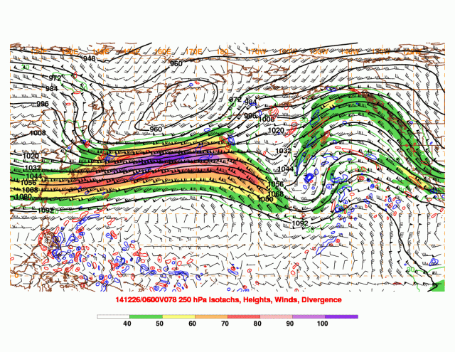
The big hindrance to this pattern change occurring in earnest and allowing cold to spill into the eastern US has been the strong Pacific jet stream. The Monday night GFS run shows a significant improvement in that regard by Friday…which isn’t too far out and should be reliable:
The jet is extremely strong across the western Pacific, but “break” south of the Aleutian Islands. This would suggest significant storms across the Aleutian Islands and Bearing Sea, and a big ridge of high pressure just east of there, which is shown unanimously by tonight’s model runs. Although the NAO isn’t exactly favorable, this type of pattern would possibly suggest a brief period of very cold weather in the north-central US, Great Lakes and possibly New England in the last few days of December, with gradually warmer weather farther south…AKA a gradient pattern as discussed above.
Given that the change in the Pacific jet that will trigger this will occur in the fairly short term, I have decent confidence in this bigger shot of cold air between say December 28 and January 2. It won’t be anything like the bigger shots from last year, but might actually get the lake effect snow machine going again for the first time in several weeks.
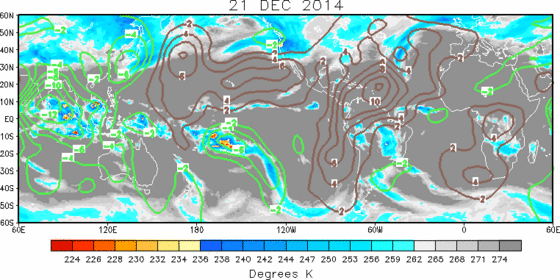
Looking at the bigger picture, I mentioned in my last post that the MJO would become unfavorable again in late December and possibly cause the cold to pull back a bit as we actually head into the first week or so of January. A look at the global satellite imagery shows very active convection across the Indian Ocean, which isn’t in a good spot for central or eastern US cold (we’d want it closer to the Dateline). Convection in the Indian Ocean typically results in the Pacific jet discussed above breaking over the NW Pacific, which puts ridging over the central Pacific and troughing along the west coast (and then ridging/warmth for the central US).
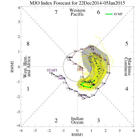
The European MJO forecasts reflect the satellite imagery above, with the MJO currently in phase 3 and then working through phases 4-6 over the next couple of weeks. Phases 3-6 correlate to warmth in the central and eastern US, with phases 7-2 being near normal or cold depending on the exact phase.
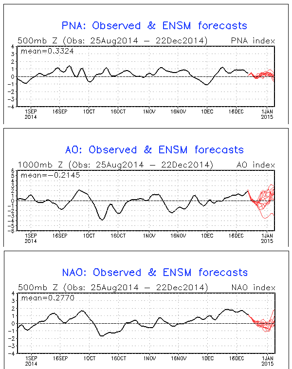
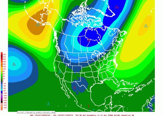
The GFS ensemble “teleconnections” also reflect a less favorable pattern heading into the New Year…with the NAO and AO rising and the PNA holding steady or falling slightly. This would also argue for a pulling back of the colder air to start January. However, the GFS ensembles do not show the Pacific pattern reflecting what a phase 3-6 MJO would suggest, as they maintain ridging over Alaska in the 11-15 day period. The Canadian and Euro ensembles also appear to resemble this to at least some extent:
My thinking is the persistent upper low over NE Asia and the NW Pacific (+WPO), which is driving our current strong Pacific jet, is expected by the models to overwhelm the MJO signal and help keep some ridging over Alaska, which would be monumental in terms of not flooding the continent like we did earlier this month, and are still seeing the effects of in terms of weaker storms.
Summing Up:
There will be a few chances for snow events over the next 10 days. I think at least one or two of them will pan out, with the favored locations being the central Plains east into the lower Great Lakes and New England, with the upper Ohio Valley and interior Mid-Atlantic possibly getting into some of the threats, especially the later ones after December 28th. The coldest air from this current pattern will likely occur in the few days leading up to the New Year, with a pull back in the cold for the first week to 10 days of January. During this time period, there may still be enough cold in Canada for some risk for wintry precipitation, especially in the Upper Midwest, Great Lakes, and New England.
For the rest of January, as I discussed in my previous post I believe the combination of a stratospheric warming event and more favorable MJO may allow for a significant cold pattern to setup in the central and eastern US. Stratospheric warming events and subsequent –AO/-NAO blocking are very hard to predict, but this one continues to come in stronger in our mid-range models and may be legitimate. I’ll look at this more later.
Jim Sullivan

