
Brief summary:
A west to WSW wind will develop Tuesday evening ahead of an arctic front. At the same time, moisture and instability over Lake Erie will increase. This should allow a band of snow to form along the eastern lakeshore, mainly in Lake and northern Ashtabula Counties, during the evening. The snow will initially be light, but become moderate to heavy after midnight. This band may persist for a few hours and drop over 6” of snow in parts of Lake and northern Ashtabula Counties. The arctic front will push south off of the lake during the pre-dawn hours on Wednesday, and a band of heavy snow with near zero visibility and gusty winds will accompany it. This band could drop a quick 2-4” of snow across parts of inland Cuyahoga, Geauga, northern Summit/Portage, Trumbull and southern Ashtabula Counties early Wednesday, with 1-2” falling elsewhere across north-central and northeast Ohio as this band swings south. This could have a big impact on the Wednesday morning commute.
Behind this band, bursts of snow may continue for a couple hours or so during Wednesday morning across Lorain, Medina, inland Cuyahoga, Summit, southern Geauga, Portage, Trumbull and Mahoning Counties with additional accumulations. By late Wednesday morning and into Wednesday afternoon it appears as though two main bands may set up across north-central and northeast Ohio due to “help” from upstream Great Lakes…one band from Lake Michigan may set up on the far west side…IE, Erie, Huron, Lorain, Ashland, Medina and Wayne Counties…and a band from Lake Huron may setup across eastern Ashtabula County east into NW Pennsylvania. The Lake Huron band will likely be heavy, with the Lake Michigan band being more light to moderate. Between these two bands, there will likely just be scattered snow showers confined mainly to the higher elevations late Wednesday morning into Wednesday afternoon.
For Wednesday night the winds will begin shifting, which may allow for one last burst of snow across the Snowbelt (Cuyahoga, Lake, Geauga, Ashtabula, Trumbull, perhaps parts of surrounding counties), with another couple inches being possible. Adding it all up, the heaviest snows will probably be across parts of Lake and Ashtabula Counties, where both of the potentially “heaviest bands” during the event look to set up. The rest of the “primary Snowbelt” in eastern Cuyahoga, Geauga, extreme NE Summit, northern Portage and parts of Trumbull Counties should see enough periods of snow showers to see 4 to locally 8”…with locally more in northern Geauga County. There could be a few inches on the west side where the possible Lake Michigan band sets up, especially in the somewhat hillier terrain inland from the lake. Elsewhere, a snow squall along the arctic front Wednesday morning and lingering snow showers through Wednesday afternoon will add up to 1 to locally 3”.
Detailed Explanation:
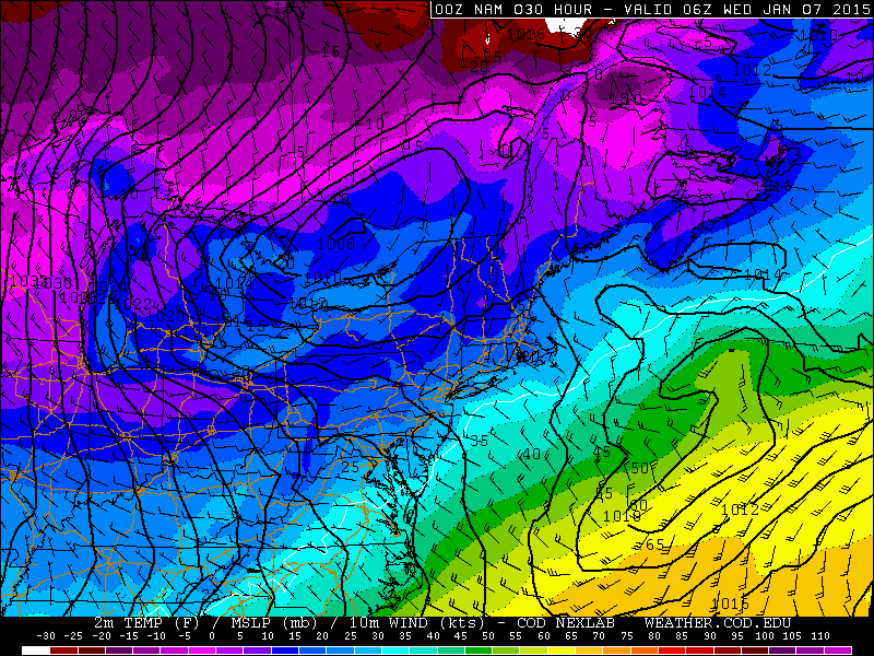
A deep upper level trough will move across the Great Lakes Tuesday into Wednesday and allow very cold air to spill into Ohio. An arctic front will drop south across Lake Erie and northern Ohio between 2AM and 8AM Wednesday, with a northwest flow setting up behind it. Ahead of the front, a strong band will likely form along the eastern lakeshore and then swing south with the front. Behind the front, questions about drier air and a short fetch due to a NW flow make the forecast tough, despite extreme lake induced instability and very high inversions.
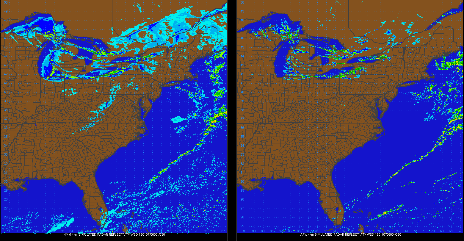
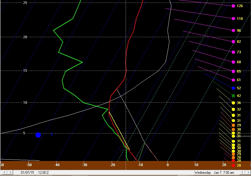
Ahead of the front, the hi-res models suggest strong convergence along the Lake Erie shoreline, with the winds trying to back to the SW over land while they become west and eventually WNW over Lake Erie. This seems like good support for a decent single band to form along the eastern lakeshore, and the NMM and ARW both show this by 1AM Wednesday:
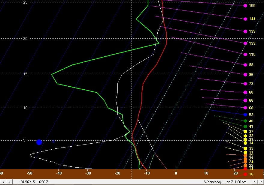
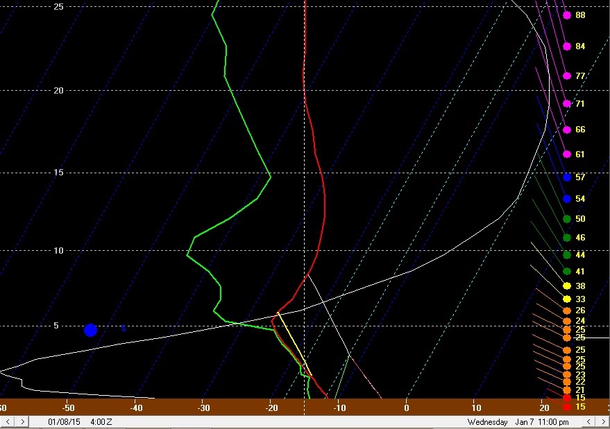
BUFKIT forecast soundings by this point indicate moderate lake induced CAPE with equilibrium levels near 8k feet and rising, with moisture depth to 6-7k feet. These parameters are all marginal to good, and with such strong convergence evident on the mesoscale models along the eastern lakeshore I’d expect a band with moderate to heavy snow to be developing quickly by this point if it doesn’t develop even a few hours sooner:
The surface winds have a good southerly component, however with decent WNW winds in the boundary layer mixing to the surface over the lake, I’d imagine the band would be a few or several miles inland across Lake and Ashtabula Counties. There is good moisture and instability in the DGZ, so I’d expect very high snow ratios on the order of 20-30:1 in any band in this timeframe, so snow rates of 1-2” per hour seem like a good bet under any banding in Lake and northern Ashtabula Counties between midnight and 4AM Wednesday.

By 4AM Wednesday, the front is approaching the lakeshore but still hasn’t pushed inland yet per the 0z NAM, GFS and Euro, so I’d expect any band to still be close to the lakeshore…although it may begin budging south. Also, note the decent convergence as far west as Toledo, suggest a burst of snow could occur across all of northern Ohio as this front drops south just before dawn on Wednesday. The convergence across Lake and Ashtabula Counties into NW PA is extremely strong, and heavy snow rates are very likely in this timeframe.

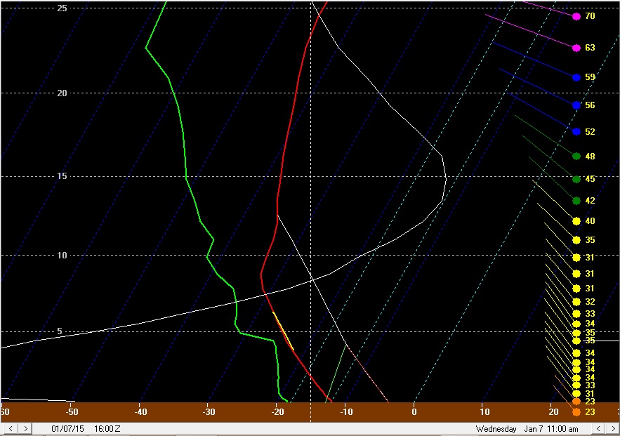
By 7AM Wednesday, the models all show the front south of Cleveland and pushing through the Snowbelt, likely with a band of heavy snow with it. By this point, lake induced instability will be extreme (800-1000 J/KG of CAPE) with equilibrium levels rising to 10-12k feet. In addition, the NAM shows very strong omega along the front (CLE briefly has -30 ub/sec!!). Any band along the front could produce very heavy snow rates, although the band will be moving so the snow may not add up a ton:
Behind the front, instability remains extreme and equilibrium heights will remain in the 10-12k foot range until mid to late Wednesday afternoon. However, the fetch will become shorter and some low-level dry air may work in, limiting additional snowfall behind the front.
The winds immediately behind the front (see the BUFKIT forecast sounding for CLE above) will be very well aligned out of the WNW for a couple of hours, so I suspect some convergence and half decent snows will hang on for a couple of hours behind the front a bit inland from the lake…mainly across parts of Lorain, southern Cuyahoga, Medina, northern Summit, southern Geauga, Portage into Trumbull and possibly Mahoning. These areas could see another couple inches right behind the front by mid to late Wednesday morning.
By later Wednesday morning and into Wednesday afternoon, the flow will be true NW (one of the shortest fetches across Lake Erie for northern Ohio), and the models show some dry low-level air working into parts of Michigan from Canada. Although the air over Lake Erie will be extremely unstable with high inversions, I’m worried about this dry air. NAM forecast soundings for CLE suggest it may be hard to maintain a deck of lake effect clouds at times:
The winds are very well aligned, the layer of instability is deep and the amount of instability is very impressive for a lake effect situation. However, with a short fetch and a good 25-35 knot flow in the boundary layer I have some concerns. This may be where upstream lake connections come into play:

The NAM shows a couple of things that concern me…first of all, it shows cold and very dry air (dew points below 0 into lower MI, and -20 to -30F dew points in the core of the colder air) working across the narrow and partially frozen portions of Lakes Michigan/Huron and working towards central Lake Erie late Wednesday morning into Wednesday afternoon. This would potentially limit lake effect off of Lake Erie given the short fetch. In addition, this cold/dry air pushes the Lake Michigan connection well west of Cleveland. It is very typical to get a Lake MI connection in a NW flow and that is often why there is a band on the west side in a NW flow. You can tell where the connection is by following the convergence in the wind barbs. Between the two connections close to NE Ohio, the winds at the surface are somewhat divergent. This would also limit how organized any lake effect between the two connections is.
Because of this, it would not surprise me at all if by late Wednesday morning after the front passes well south and the winds become true NW that the lake effect across the Cleveland metro and also Lake and Geauga Counties becomes very weak/disorganized for a few or even several hours, with perhaps just light accumulations in this timeframe in the higher terrain. There could be heavy snow in eastern Ashtabula County into NW PA under the Lake Huron connection and perhaps decent light to moderate snow in the Lake MI connection well west of Cleveland. Snow ratios during this time frame might not be great either due to the drier air causing the ceilings to climb above the DGZ for a few hours Wednesday afternoon.
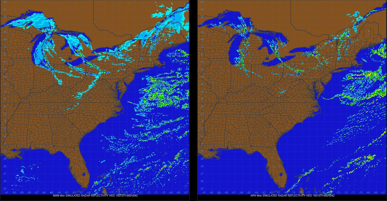
The NMM and ARW also show the cold/very dry air trying to work its way down towards Lake Erie early Wednesday afternoon:
Note how they both show one band west of Cleveland (one model shows it stronger than the other) and the Lake Huron band well east of Cleveland at the same time:
By Wednesday evening, the winds will begin backing to a more WNW and eventually W direction, which will lengthen the fetch over Lake Erie and perhaps allow some upstream conditioning from Lake Michigan and increase moisture some:

By this point, there will still be decent instability and pretty high equilibrium levels, and convergence will increase some along the central lakeshore and into the Snowbelt as high pressure moves in, so there will probably be an increase in snow Wednesday evening into Wednesday night across northern Lorain, Cuyahoga, Lake, Geauga, Ashtabula, Trumbull and possibly northern Summit/Portage that drops another 1 to locally 4” of what by that point should again be high ratio snow:
By 3-4AM the winds go pretty WSW which should confine things to the lakeshore by that point and effectively end the event for most of us…
So, how did I figure accums?
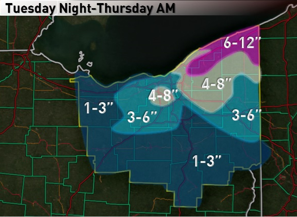
I figured 4-8” Tuesday night in Lake and northern Ashtabula Counties due to the band I expect to develop there…and then 2-3” across Cuyahoga, northern Medina, northern Summit, Geauga, southern Ashtabula and northern Trumbull as the arctic front drops south early Wednesday, with possibly another inch or two immediately behind the front across parts of Lorain, southern Cuyahoga, northern Medina, northern Summit, southern Geauga, northern Portage into parts of Trumbull, which pushes those areas to 3-5” by mid to late Wednesday morning. The arctic front could produce a quick inch or so everywhere else across north-central and NE Ohio outside of these areas. After the arctic front, I figured another 2-4” Wednesday afternoon across eastern Ashtabula County due to getting fringed by a potentially very heavy Lake Huron band…and perhaps another 1-3” across parts of inland Lorain, eastern Huron County into parts of western/southern Medina and maybe even the higher elevations in northern Ashland Counties due to the Lake MI connection there…with maybe another inch in the higher terrain in the primary and secondary Snowbelts. I think figured another 1-4” from Cuyahoga east Wednesday evening into the overnight with the last flareup I expect.
This pushes most of Lake and Ashtabula up to 6-12”, with perhaps a little more in eastern Ashtabula if they do get into the Huron connection. This gives a wide 4-8” area in the rest of the primary Snowbelt and surrounding areas. I drew 3-6” amounts well west to account for the possible Lake MI connection in that area. I didn’t feel comfortable with leaving the higher terrain in SW Cuyahoga and northern Medina in just 3-6” so I added a small 4-8” area there as well. Due to favorable orographic lift in northern Geauga I figured they could squeeze out a little more in every phase of the event so I also drew 6-12” in there. Although I didn’t draw it in on this map, I expect 1-2 feet across a good portion of Erie and Crawford Counties PA as they should also get in on the band Tuesday night ahead of the front and also the Lake Huron connection for several hours on Wednesday.
