

Several images used are from Tropicaltidbits.com…great site.
If you think it’s been cold during the first half of January, you’re correct if you live east of the Rocky Mountains. With the exception of Florida, essentially all of the central and eastern US have seen a below to well below normal start to January in the temperature department. There will be a brief relief in that in the coming days, but it won’t last long.
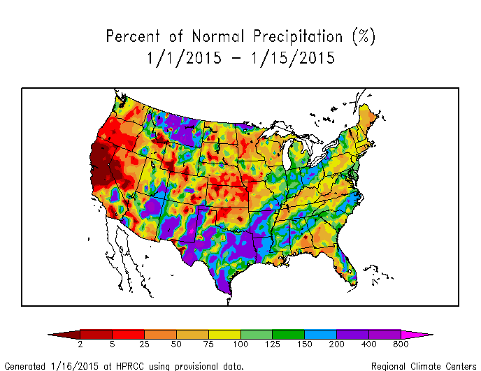
Unfortunately for snow lovers, this cold hasn’t been accompanied by a lot of precipitation, with much of the central and eastern US, with a few exceptions, seeing a much drier than normal start to January. This has caused unrest among many weather weenies on various Facebook pages and message boards…the question is, will this continue?

When looking at the global circulation pattern over the last 30 days, it is evident what has driven the cold over the central and eastern US. A large ridge of high pressure along the West Coast extending well into Alaska (+PNA), almost to the North Pole (-EPO), caused the polar branch of the jet stream to move over Arctic Circle before crashing south towards the central and eastern US with lots of very cold air. This pattern was driven by a persistent –WPO and a somewhat favorable progression of convection in the Tropics in early-mid December. Meanwhile, the NAO has remained positive. So while there has been a somewhat active sub-tropical jet (note the modest dip in the jet near the Baja of California), the polar branch of the jet stream has featured a broad trough with fast moving systems that can’t really “phase” with the sub-tropical jet and create large storms…hence the general lack of strong storms (and heavy snow) in the central and eastern US in December and into the first half of January, despite plenty of cold since late December. Typically, an active sub-tropical jet leads to an increased chances for moisture laden storm systems with heavy snow, however we need the polar jet to cooperate to an extent as well.
The question becomes, will this change moving forward?

A current look at the hemispheric weather pattern does look a bit concerning if you want cold and snow…heights are rising over Greenland which is “attempting” to make the NAO go negative (it’s not really negative enough to help at this point), however the ridging along the West Coast and into Alaska has vanished, with a surge of mild Pacific air spreading east across the country this weekend. As “bad” as this looks, changes are right around the corner:

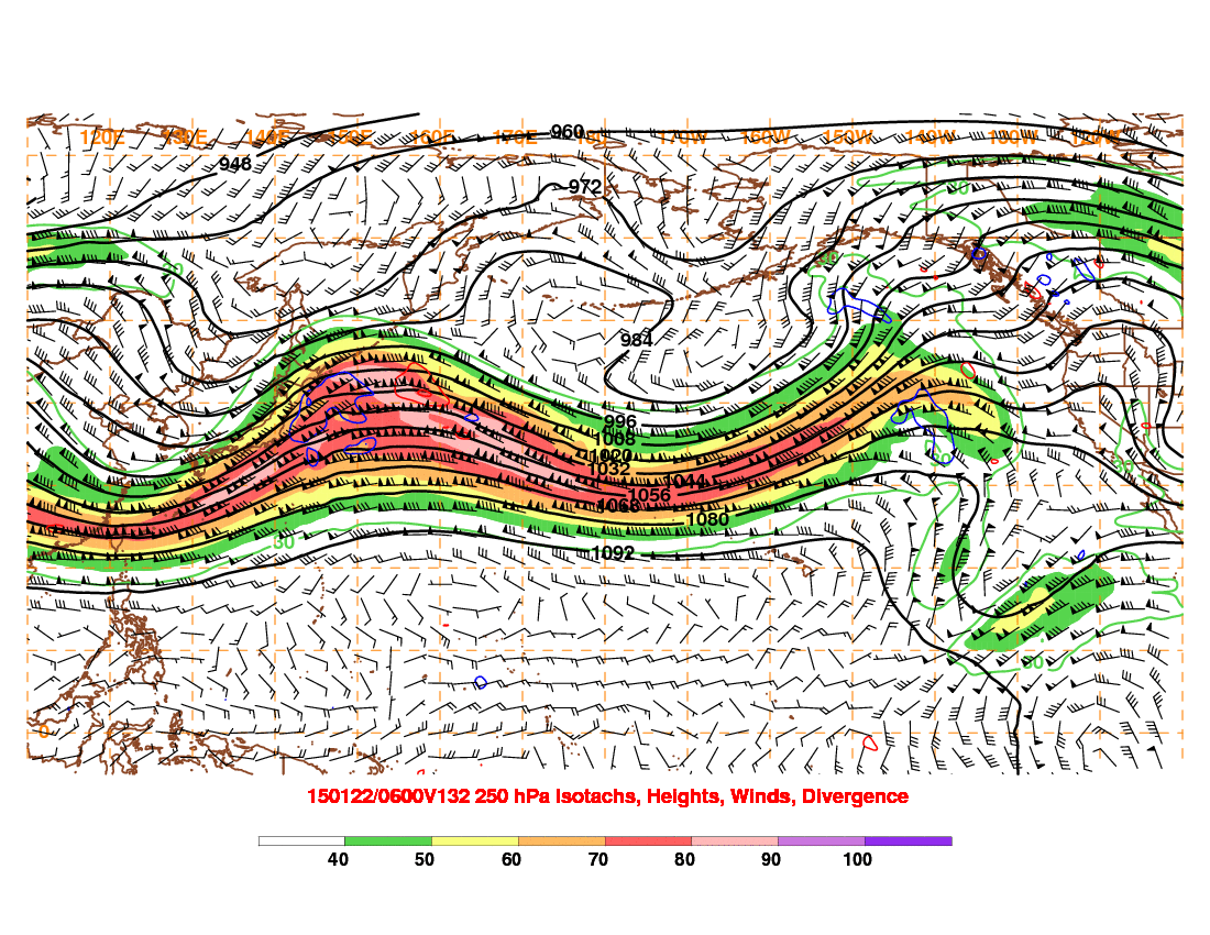
After starting January with extremely active convection in the tropical Indian Ocean, which eventually contributed to the strong ridge on the West Coast and into Alaska discussed above breaking down, the convection is now most active over the Pacific Ocean. This is favorable for ridging over western North America, because the convection located over the Pacific favors a strong jet stream over the western and central Pacific that breaks over the eastern Pacific, causing storms there that increase heights (cause a ridge to develop) along the West Coast. You can see this favorable jet orientation on the GFS forecast valid Sunday morning:

Note how the winds really fan out south of Alaska (called upper level divergence), which favors storms in that region and increasing heights to the east. By the time we hit the middle of next week, the model responds by building a ridge along the West Coast, and still has a fairly favorable jet orientation for continued ridging:
Indeed, both the GFS and European ensembles agree on a decent ridge along the West Coast in the 6-10 day timeframe:

(Image courtesy of tropicaltidbits.com)
This isn’t the best looking map for snow in the central and eastern US, HOWEVER, the ridging in the West Coast of the continent is tall enough to allow for seasonably cold conditions across the north-central US and northeast US. There is also an active sub-tropical jet, evidenced by the negative height anomaly off the SW coast. This map suggests that some clippers would be likely in the Midwest/Great Lakes region, with possible redevelopment along the East Coast, especially if there’s involvement with the sub-tropical jet. The big elephant in the room is the continued +NAO/AO, which does hurt chances for more significant snow storms in the central and eastern US (the trough is also too far east for big, wound up storms west of the Appalachians in the GEFS above, although the Euro ensembles do look better) in this timeframe. We’ll discuss the NAO and AO more shortly.

The MJO, which describes where thunderstorms are most active in the Tropics, has moved into phase 7 and may move into phase 8 shortly, after moving through phase 5 and 6 at very high amplitudes last week. Although not a perfect match, the pattern progression is following along with the typical MJO correlation to an extent:
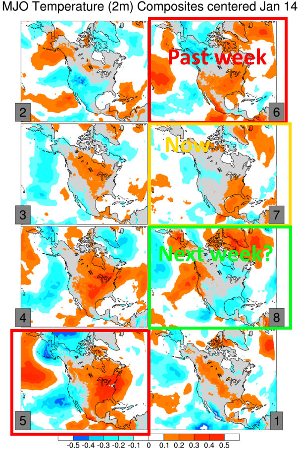
(There is a bit of a lag, on the order of a few days)
If the MJO does head into phase 8 (it’ll be close), that correlates with cold air over the central and eastern US, which jives with current model forecasts and also supports what the orientation of the Pacific jet stream suggests should happen (although granted, the Pacific jet is driven in large part by the MJO). The MJO isn’t expected to emerge into the unfavorable phases until at least early February, suggesting that western North American/NE Pacific ridging should be fairly persistent through the rest of January and into February, at least.
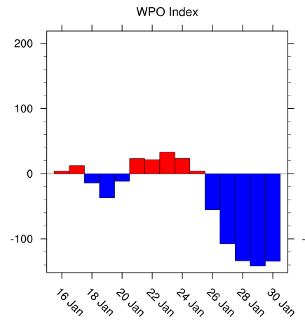
Another factor supporting continued ridging here is the expected continued –WPO in the mid-long range. The WPO or West Pacific Oscillation describes the height pattern in the northwestern Pacific…here is a look at the positive phase graph:

Flip the anomalies to get what correlates to a –WPO (ridging over Alaska and cold over the central and eastern US). Although the WPO is currently more neutral, it was fairly negative in late December and early January, and the GFS ensembles currently project the index to go strongly negative for the last week and January (and likely into February):
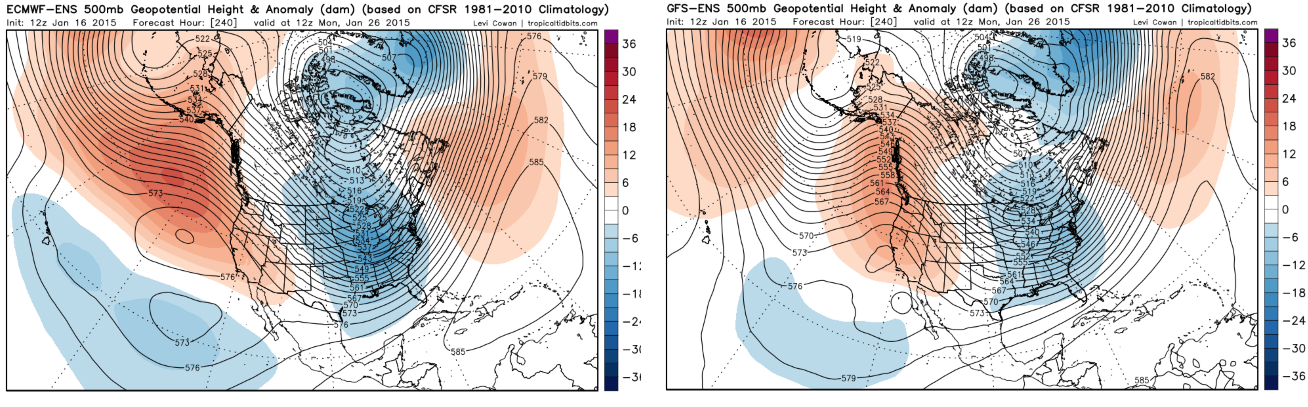
The factors all seem to point to a decent period (the rest of January and likely into at least the first week of February) of ridging over western North America or the NE Pacific, suggesting troughing in the central and eastern US. Indeed, by January 26, the European ensembles show strong ridging in both the WPO/EPO regions and a corresponding deep trough in the central and eastern US, which would suggest below to well below average temperatures in this region:

The sub-tropical jet still also looks active, denoted by the negative height anomalies from Hawaii to near Mexico. The big issue continues to be the lack of a –AO/-NAO in the above image, which makes it harder to see large snow storms in the eastern US. A +NAO can result in large snow storms for portions of the Midwest and Great Lakes, but makes it harder to see heavy snow on the East Coast (storms are more likely to cut inland or into the Great Lakes). It is possible the trough edges west and is centered more on the Ohio/Tennessee Valleys by next weekend due to the ridging becoming more WPO/EPO based as opposed to PNA based, which could bode well for parts of the Ohio Valley/Great Lakes if a favorable phase can occur.
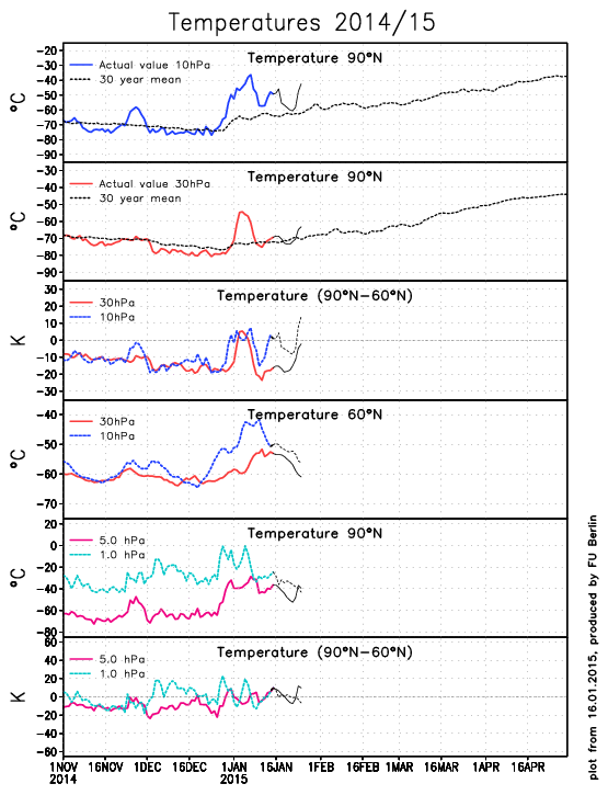
There are a couple of things that can cause a –AO/-NAO to develop…a major warming event (MWE) in the stratosphere, and/or continued wave breaking along the US East Coast, which would increase heights across the North Atlantic (much like what I discussed above about the Pacific). There was a sudden stratospheric warming event (SSW) earlier this event in the stratosphere, however the polar vortex there has reconciled recently, albeit in a weakened state:
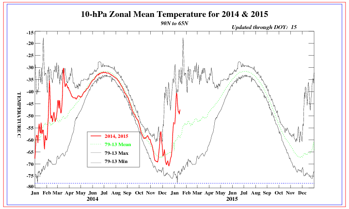
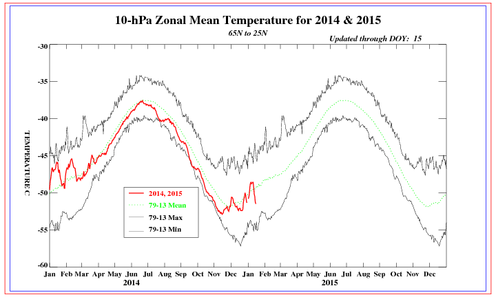
Note how temperatures in the arctic stratosphere briefly warmed to near the daily record values at the 10mb level, although they have cooled some since the warming. This does NOT count as a MWE. Temperatures in the mid-latitude stratosphere have cooled in this timeframe, suggesting a weakening of the stratospheric polar vortex:
Warming events in the stratosphere often do end up downwelling to the troposphere about two weeks after they happen and cause a tropospheric –AO to develop. This warming event just qualified as a weak SSW event, and the stratospheric vortex, after “splitting” for a couple of days, is back into one piece again. So, it is uncertain if a –AO event will develop due to this event, and in fact I’m leaning somewhat against it. However, the stratospheric vortex is still weaker, so continued warming, which COULD occur in the 10-14 day timeframe if strong ridging forms in the WPO and EPO regions, could easily disrupt the vortex again, and make a strong –AO possible in February:
The European model does appear to show renewed warming by the day 10 timeframe (note the projected temperatures in the 60-90N area spiking again near the end of the forecast). IF this is accurate, the continued bombardment on the stratospheric polar vortex could cause the vortex to split during the last week of January, resulting in a –AO for February. Given strong signs for decent WPO and EPO region ridging in the 7-14 day timeframe (especially after day 10), I feel decently confident in this stratospheric warming occurring, and this could bode well for February.
As for the NAO, I’m not optimistic about –NAO development through the end of January. There don’t appear to be any strong storms over the eastern US/SE Canada over the next week or so to help raise heights over Greeland, and with the AO likely not going negative until February, there isn’t much to help the NAO go negative either. The GFS ensembles (and although I can’t show them to you, the Euro ensembles as well) continue to insist on negative anomalies extending from Greenland to the UK for the foreseeable future (+NAO), after a weak –NAO over the next 5 days or so:

NOW, as we head into February, if we can maintain the western N. American/Northern Pacific ridging and keep a trough in the central and eastern US, and see a better AO condition, we could then see the NAO go negative.
There are a few chances for snow across the Midwest/Great Lakes/Northeast over the next week or so:
Sunday-Monday:

A pretty good shortwave is expected to move through the Great Lakes. Although this isn’t a classic –NAO, higher heights from SE Canada to just south of Greenland will cause this shortwave to slow down and take on a negative tilt as it nears the East Coast. Ridging over the western US is still pretty flat at this point, and there isn’t a classic –NAO/50/50 low combination off the East Coast, so although this storm could redevelop into a pretty good low pressure near the New England coast, the only areas that may see decent snows are parts of Upstate New York and interior New England.
Wednesday-Thursday:

Another pretty decent shortwave is expected to move through the Great Lakes and then through New England Wednesday into Thursday. Our models are trying to show this system taking on a negative tilt over the Great Lakes, which could result in a swath of half decent snows across Wisconsin and Michigan perhaps. By this point, the NAO situation still isn’t any better, although ridging has built up over the western US and Canada, which could allow this low to possibly redevelop a bit farther south than the Sunday-Monday system. There isn’t much to keep this from zipping out to sea, however a swath of light snow could be possible across Upstate New York, New England and perhaps the northern Mid Atlantic as well if this shortwave comes in rather strong over the Great Lakes…not a huge system, but perhaps some snow.
Saturday-Monday (January 24-26):
Both the GFS and European ensembles show the trough really amplifying, centered either over the Ohio Valley (Euro) or East Coast (GEFS), next weekend, with hints of a cross polar flow developing due to ridging over western N. America. This could cause a decent cold shot to come down, and if the interaction with the active sub-tropical jet is right, could cause a good storm. We will have to watch to make sure the –EPO isn’t too strong in this timeframe, which would cause suppression of any storms.
With no –NAO, a trough oriented as far west as the Euro ensembles show would favor the Ohio Valley and Great Lakes for snows if a storm occurred. The GFS ensembles would support a track close to the East Coast (possibly rain for I-95 and snow inland). The key here is, we would need to get phasing with the active sub-tropical jet for a storm to occur in this timeframe. But the look is pretty decent, and if a strong storm occurred, perhaps it could start the process in gradually building a –NAO towards February.
So, in summary:
Week of 1/19-25:
-Colder air spills into the north-central and NE US. The temperatures will probably only be somewhat colder than normal, nothing brutal. There could be a couple of clippers across the Great Lakes or Upper Ohio Valley with swaths of light snow, and possibly re-development off the New England coast that gives parts of Upstate New York, New England (especially the interior) and perhaps the far northern Mid-Atlantic some light to moderate snow. Warm/dry in the west, wet in the south-central and southeast.
Week of 1/26-2/1:
-I believe the trough could become centered over the Ohio Valley due to the ridge becoming more WPO/EPO based (as opposed to +PNA based). With no –NAO, this favors storms tracking well inland from the East Coast, either up the Appalachians or into the eastern Great Lakes. If we can get a favorable phase between a system running through the potentially deep trough and what looks to be an active sub-tropical jet, a good storm could occur if the -EPO isn’t too strong. Due to hints at a cross polar flow, there could be a period of well below average temperatures this week, especially in the Plains, Midwest and Great Lakes.
Into February:
It may take several days, however, with the MJO currently not expected to become truly unfavorable into early February, and with potential for better high-latitude blocking in the AO and NAO regions for reasons discussed above, we may see a more favorable pattern develop for East Coast winter storms, with cold weather across the central and northern US.
This is a long ways out and could change, but for reasons I discussed above, I believe things may tilt in that direction in February, potentially by the second week of the month. If a –NAO struggles to develop still, this could end up boding better for areas in the Ohio Valley/Great Lakes instead.
