
Please click on images for full size.
A strong clipper system (due to its origins, is known as a “Manitoba Mauler”) will move through the Ohio and Tennessee Valleys on Sunday, producing snows. The clipper will move off the Carolina coastline Monday morning, and a Nor’Easter will develop from this clipper and track north-northeast up the East Coast. This Nor’Easter appears to have the potential to produce a significant amount of snow, high winds and blizzard conditions.
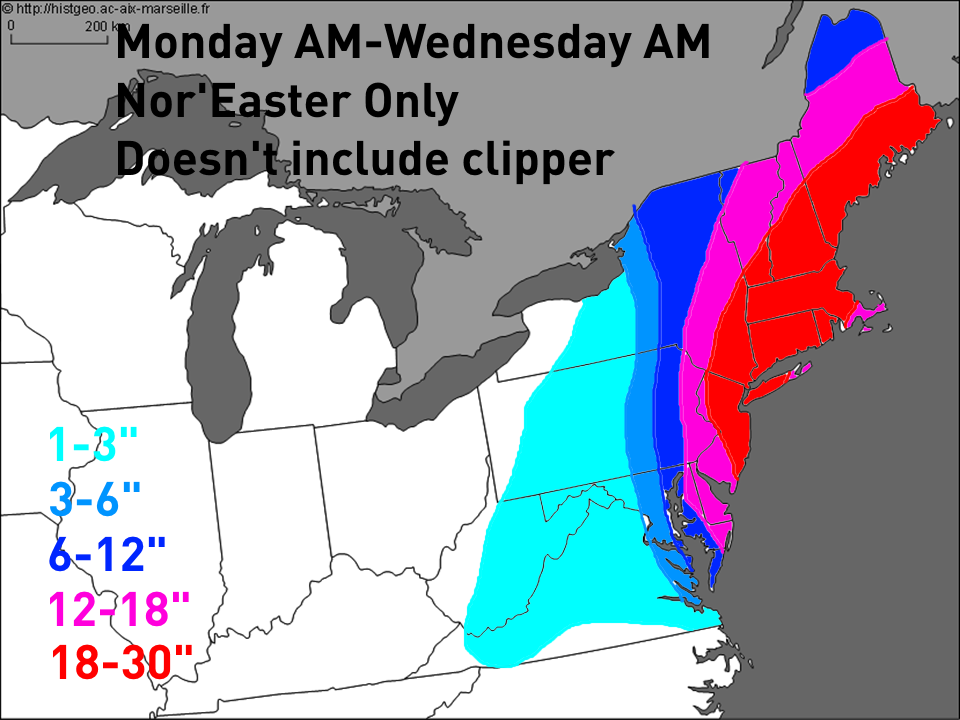
Here is my first attempt at guestimating snowfall amounts for this storm. Barring massive changes, amounts of over 2 feet in the hardest hit areas seem likely…probably in southeastern New England but possibly as far southwest as New Jersey. There will be a sharp southwestern cut off to the snow…as of now, for reasons I present in the text below, I believe that Philadelphia will get in on the heavier snows, while DC and Baltimore are in that area that may or may not see heavy snows, depending on exactly where our storm tracks and how quickly it intensifies. There may be changes to these estimates and I will try to update again tomorrow. Please note, this map does not include snows that will fall from the “clipper” Sunday and Sunday night. The clipper may drop a swath of moderate snow from Indiana and through Ohio and into Pennsylvania. That is NOT included on this map:
Detailed Discussion:
The track of a “clipper” system through the Midwest and Ohio Valleys has shifted drastically over the last 2 days, with the clipper now expected to drop into the Tennessee Valley before rounding the corner and tracking up the East Coast with heavy snow for parts of the region. The clipper was initially expected to take a much “flatter” track off the East Coast and only drop moderate snows, but that has changed.

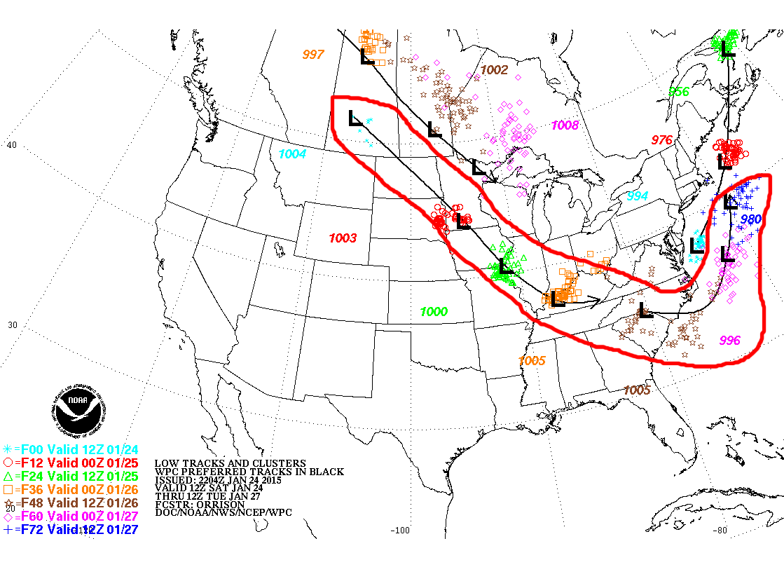
You can see how our models are now handling the clipper that will lead to this major East Coast snowstorm differently now (right) vs Friday morning (left). The clipper drops farther southwest and is noticeably stronger. This allows the clipper to “round the corner” farther west and come up the East Coast. You can see why the farther south solution for the clipper has really opened the door up to a potentially large East Coast snowstorm when looking at the large scale weather pattern:
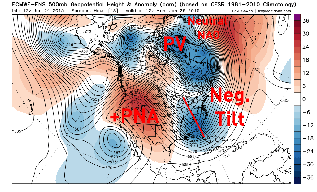
The Atlantic pattern initially looked like it wouldn’t be extremely favorable for a significant or major East Coast snowstorm when this clipper moved off shore. It was assumed the clipper wouldn’t take on a negative tilt until it moved off the coast, and without a classic –NAO block over Greenland, it was expected that snow amounts would be more moderate for parts of the Mid Atlantic.
NOW, the clipper dives far enough south and is strong enough that it takes on a negative tilt while moving over the Appalachians. This is considerably farther west than expected through Friday, and is in a great spot for a major East Coast storm. The Atlantic pattern isn’t optimal, BUT, the polar vortex (PV) is in a good enough location that it acts as a pseudo “50/50 low” and helps lock in cold over the Northeast US…something that was lacking with the Friday night Nor’Easter, which caused the big I-95 cities south of NYC to see a considerable period of rain instead of snow. The negatively tilted trough is important because it signifies a strengthening area of low pressure at the surface, often causes the storm to slow down and often causes the storm to hook a bit to the “left” in terms of its track. A neutrally tilted trough as expected as late as Friday on the East Coast would NOT have allowed this big storm to occur close enough to the coast for heavy snow. Well, that has changed.
The CIPS analog tool allows you to find out what past upper-level weather patterns similar to what is modelled in the coming days have produced in the past. I will show you the analog guidance based on two timeframes…one Monday evening, just as the clipper is getting ready to move off the coast, and one Tuesday morning, as the major Nor’Easter is expected to reach peak intensity:

By this point, we have a negatively tilted shortwave along the East Coast, although rapid deepening hasn’t begun yet. A negatively tilted shortwave in this position is already a good sign for a major East Coast storm…out of 15 top CIPS analogs for the above weather pattern, the mean snowfall for the East Coast was light to moderate, with heavy amounts for New England:
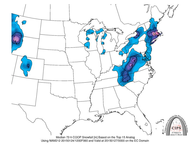
If you move the analogs ahead 12 hours to when our models expect the storm to really “bomb out” off of the Mid-Atlantic and New England coasts, the mean snowfall for the top 15 analogs to that scenario is significant for much of the eastern Mid-Atlantic and New England:
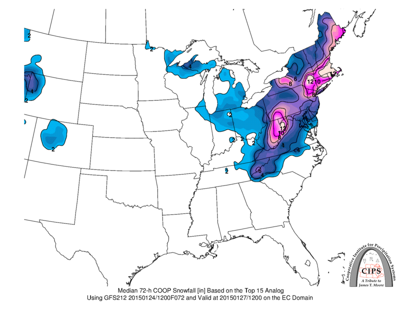
So, we have some historical precedence for heavy snows when a shortwave takes on a negative tilt on the East Coast and causes a rapidly intensifying low pressure as our models are expecting Monday into Tuesday.
The question is, are the models right in their depiction?

When looking at the energy in the mid-level of the atmosphere Monday evening, you can see the factors that will help contribute to a solution similar to what today’s models show…a significant East Coast snowstorm. Our clipper, labeled with an L, has taken on such a strong negative tilt that the upper level flow (the black lines and wind barbs) is south-north…which suggests any low pressure would track up the coast instead of out to sea. In addition, a second “shortwave” (labeled X) is dropping into the larger trough over the East Coast. This system drops in to the west and south of our clipper/developing East Coast low and re-enforces the negative tilt of the trough…it also helps tug the East Coast low to the southwest, which contributes to a slow movement of the low pressure as it moves up the coast and strengthens.
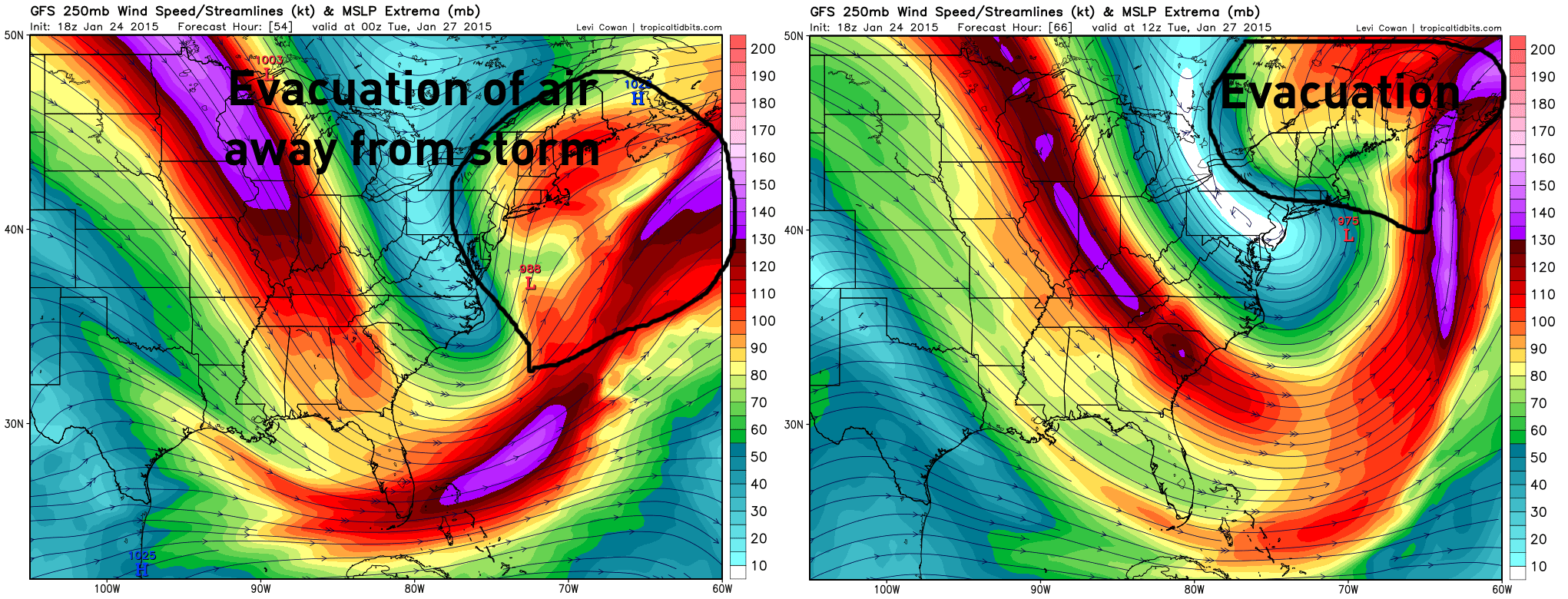
All of the things discussed above…the negative tilted trough, the slow movement of the storm…contribute to a better environment for a quickly deepening low pressure system off the East Coast. In the above two-panel image of the GFS model valid Monday evening on the left and Tuesday morning on the right, you can see high-speed air in a “jet streak” in the upper levels of the atmosphere rushing air away from our strengthening low pressure system…especially by Tuesday morning. If the trough doesn’t go negatively tilted, this evacuation of air, called “upper level divergence,” is not nearly as effective, and the storm strengthens slower. Again, the clipper diving farther south and becoming stronger than previously expected is absolutely key to this scenario. However, as is, all systems appear to be go for a strengthening low pressure system off the East Coast with heavy snows for the big I-95 cities, especially from New Jersey points north, due to the polar vortex acting as a pseudo 50/50 low and locking cold air in place over the Northeast US.
The big question becomes: Where will it snow and how much?
Currently, the Weather Prediction Center has a low risk of 4”+ snow from the Delmarva Peninsula points north…with high risks for 8” and 12”+ of snow over parts of southeastern New England. I believe these probabilities are extremely conservative on the southwestern side of things.
Don’t get me wrong: clippers that re-develop along the coast often have a very sharp southwestern cut-off to the snow, and often screw portions of the Mid Atlantic in terms of snow…however, I believe this storm will re-develop far enough west and track far enough west for more snow farther west than these maps imply.
Between our two “best” models this afternoon, the European model showed very heavy snow much farther west than the WPC expects…while the WPC favored a solution closer to the GFS. I normally can’t post Euro model snow maps due to copyright issues, however, this snow map has been floating around on social media all afternoon, so I figured I’ll pluck it down off of Facebook and put it in here:

The GFS model on the other hand was a little bit faster with the storm and developed it a little slower, resulting in considerably less snow outside of eastern New England:

Out of the rest of our main models this afternoon, the Canadian and UKMET were both also much closer to the GFS.
HOWEVER, the European ensembles came in resounding support of the operational Euro, with a slower storm track and quicker intensification, and hence more snow farther southwest:

Note how by Tuesday morning the operational Euro and its 50 member ensemble are both very similar in placement of the low pressure…the operational is maybe 30 miles west of the ensemble mean. Also note how the ensemble mean has a central pressure of 983MB, as deep as the op…considering this is a 50 member mean and that there is some variation in the members, this likely means that many members actually have a stronger low. Note how the color fill represents a closed upper level low over the Mid-Atlantic coast in a very similar position on the operational and ensemble forecasts. When the Euro and its ensembles agree this well in an East Coast winter storm situation, you need to listen. The Euro earned its nick names over the years (such as “the King” and “The Doctor”) by nailing East Coast snow storms while the GFS struggled until the last minute.
Not only is this ensemble support a great sign for those who want more snow in the Mid Atlantic, but the clipper that will eventually move off the East Coast Monday morning and cause all of this continuing to trend stronger and farther southwest, along with it taking on a strong negative tilt as it gets to the East Coast, and the shortwave diving into the trough of the storm on Monday night west of our deepening Nor’Easter argue strongly for the Nor’Easter that develops to move slower and become strong faster. This all sounds fine and dandy…but then, this evening’s next GFS run came in and trended STRONGLY towards the Euro:

More snow and much farther west with it. In addition, although it’s not quite as far southwest as the Euro yet, note how the GFS now also has a closed off mid-level low along the Mid-Atlantic coast Tuesday morning:

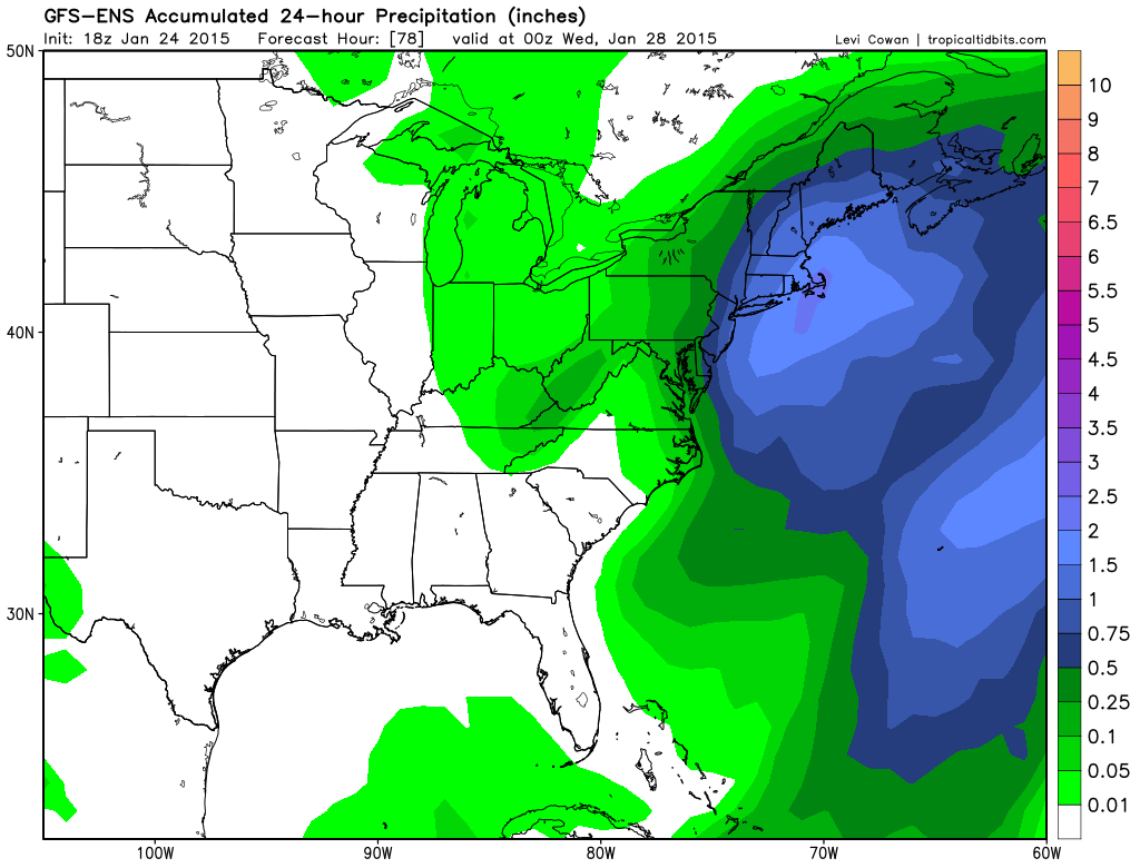
That’s a pretty good jump towards the Euro in one run of the GFS. In addition, this evening’s run of the GFS ensembles also show decent snows back through New Jersey and down towards the Delmarva:
Not only does the GFS seem eager to jump into bed with the Euro’s solution, likely due to the strong negative tilt of the trough when it hits the East Coast, but one of the closest analogs from a pattern perspective that has been brought up today for this storm is the Lindsay Day Storm in February of 1969:
This setup also lacked a strong –NAO and 50/50 low…move of a thumb ridge in the northeastern Atlantic…however, the polar vortex was in very similar position east of Hudson Bay as to what is expected for the upcoming storm, with ridging over the western and into the central US. It is uncommon to get big East Coast storms without a good –AO and –NAO, but this setup managed to pull it off. Also note where the shortwave is, moving off the VA/NC coast and taking on a negative tilt. If anything, the shortwave for the Lindsay storm is a little weaker and farther northeast than the one that will move off the southeast coast on Monday, and a bit weaker. This suggests that our upcoming storm could produce heavy snows even farther southwest than the Lindsay Day storm:
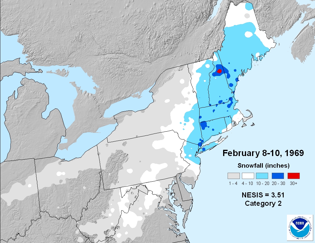
The Lindsay Day snowstorm produced heavy snows right up to Philadelphia and into extreme eastern PA, with a very sharp cutoff any farther southwest. If our storm comes in stronger than the Lindsay storm and a tad farther southwest, this would likely mean the typical Miller B “screw zone” is even west of Philadelphia…meaning Philly gets in on good snows.
So, I am favoring the heaviest amounts from near NYC up through eastern New England, with heavy snow as far southwest as Philadelphia and the Delmarva before quickly tapering to the southeast. IF the clipper that will cause all this comes in any farther southwest, more snow may occur farther southwest too. The models all generally track this Nor’Easter very close to the 40/70 benchmark…storms that track near or over 40N, 70W take an ideal track for significant amounts of snow in the Mid Atlantic and New England.
As for how much snow will fall, the GFS and Euro both agree on over 2 feet falling in the hardest hit areas. This will be a strong and slow moving Nor’Easter, so excessive amounts aren’t impossible. Once the upper level low with the Nor’Easter “closes off” over the Mid Atlantic, it will only slow drift to the northeast past New England per the Euro and new GFS. This slow movement favors amounts of 2 feet or more where the heaviest snow occurs. In addition, this afternoon’s Euro run actually showed the surface low with this Nor’Easter executing a cyclonic loop off of the New England Coast. Strong Nor’Easters that execute such loops close to the coast also often tend to produce at least 2 feet of snow in the hardest hit locations. Given all of these factors pointing to very heavy snow, I expect at least 2 feet in the hardest hit areas…somewhere in the corridor from northern New Jersey into eastern New England.
This Nor’Easter will be very strong, with wind gusts in excess of 60MPH likely near the coast. Blizzard conditions are a very distinct possibility for both Boston and New York City barring major changes.
