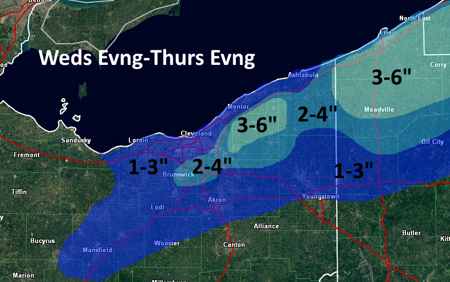
It won’t be the most snow ever, but it could be enough to move around in parts of Northeastern Ohio Wednesday night into Thursday as a potent shortwave diving through the Great Lakes and upper Ohio Valley sparks some light synoptic snow, with cold/moist air allowing for some lake enhancement to occur.
A multitude of surface cold fronts/troughs will drop south across Lake Erie and northern Ohio between Wednesday evening and Thursday evening, each of which could be the focus for light synoptic snow and some lake enhancement.
Clouds didn’t clear over the central or western basin on Tuesday, although they did clear over the eastern basin and showed some cracks in the ice, but no large openings. There appeared to be a discernable opening in the ice along the SE MI shoreline, but it was hard to tell for sure. Nothing in the central basin between the islands and Lake County was really visible on Tuesday, which is unfortunate.
A cold front will swing through Wednesday evening. Moisture depth is limited with this feature and it won’t be cold enough for lake enhancement, so I expect snows with the front to be limited to an inch or less.

Behind the front, WNW to NW winds will develop and a fairly deep layer of conditionally unstable lapse rates will develop as colder air pours in. The winds could be better aligned, but directional shear doesn’t appear to be more than 30 degrees. Inversions on the Tuesday evening runs of the GFS and NAM rise to around 7k feet behind the cold front overnight Wednesday night with high RH air to about that level. With a WNW to NW wind and moisture pooling ahead of another surface trough beginning to drop across Lake Erie from the north early Thursday, along with some low-level moisture from Lake Michigan in this timeframe, a combination of frictional convergence along the central lakeshore and orographic lift in the higher terrain from eastern Cuyahoga County eastward through Geauga County and also in NW PA could cause light to moderate snow showers to redevelop Wednesday night behind the cold front as colder and more humid air filters in. Synoptic convergence caused by the surface trough dropping down late Wednesday night into Thursday morning should be maximized for a couple or few hours along the Lake Erie shoreline into the Snowbelt. This could all cause another 2-3” of snow overnight Wednesday night into Thursday morning in the higher terrain in eastern Cuyahoga and Geauga Counties and NW PA, with less in the lower terrain…maybe an inch or so with the trough passage.
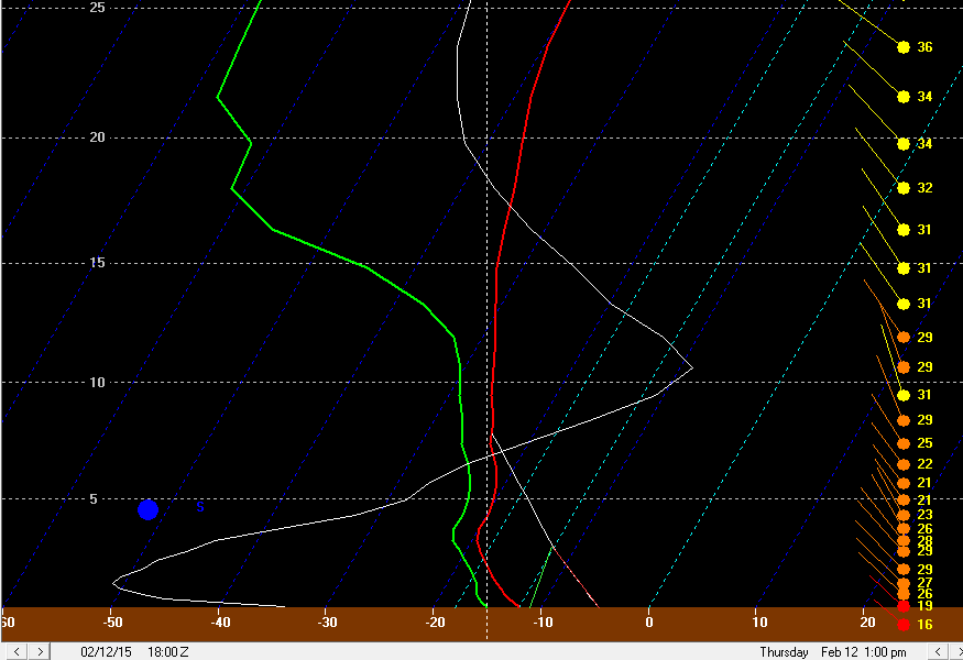
Behind this trough, there could be a brief disruption in any snow due to increased wind shear. However, by later Thursday morning into Thursday afternoon, winds become pretty well aligned out of the NW with inversion heights of 6-8k feet, and high RH air to above 700mb. This could allow very high ratio orographic lift snow to redevelop for a few hours, especially in eastern Cuyahoga and Geauga and inland NW PA, although with a more true NW wind by this point the higher terrain in southern Cuyahoga/NE Medina/NW Summit could see some orographic lift snow too. With another surface trough dropping through late Thursday afternoon, there could also be enough synoptic lift and moisture for light snow showers to break out again elsewhere and to help any orographic lift snows in the higher terrain. Given how high ratio this snow looks to be (I could see ratios of 30:1 or better for a time late Thursday morning and early Thursday afternoon before it starts getting cold enough to limit dendritic growth) I could see how the higher terrain in eastern Cuyahoga and especially Geauga and NW PA see another 2-3” or snow from this “phase” of the event…with maybe 1-2” in the higher terrain in the secondary Snowbelt and an inch or less elsewhere.

heights lower. With so much ice on Lake Erie, things will probably die down to just flurries pretty quickly Thursday evening outside of a possible Lake Huron connection in Ashtabula County or NW PA, where perhaps another couple inches or so could still fall Thursday evening through early Friday.
This all does add up to potentially 4-6” of snow in the higher terrain of Geauga County and potentially eastern Cuyahoga County…with perhaps a little more in NW PA if a Lake Huron connection can develop…perhaps 2-4” in the higher terrain in the secondary Snowbelt, and about 2” or snow in the rest of the Cleveland metro at lower elevations…spread out over the course of 24-30 hours. Given how dry/high ratio the snow will be, this isn’t a huge impact and probably not enough for an advisory, except for maybe NW PA if the Huron connection does pan out.
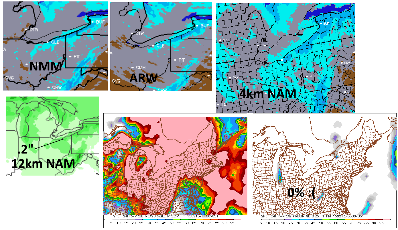
As for model support…the NMM and ARW, along with the 4km NAM runs both do spit out 0.2-0.35” of QPF in the higher terrain of the Snowbelt. With high ratios, that does fluff out to about the numbers I laid out above, although it isn’t extremely exciting. Given the extensive ice on Lake Erie and only limited upstream lake help in NE Ohio, and a lack of better synoptic lift through the “event”, I don’t see a ton of potential for this to really over-perform and produce a surprise 6-8” in less than 12 hours like the 1/30/15 event did in parts of Geauga County and also eastern Ashtabula County into NW PA. However, I can see how the orographic lift snows produce half inch per hour rates for a few hours at a time given what should be enough moisture due to the synoptic moisture pooling with the troughs, a little upstream lake moisture, and a little moisture from Lake Erie and high ratios. This does support a few inches or so possibly falling over the course of 24 hours or so. If the 12km NAM or any SREF members were spitting out over a quarter inch of QPF, I would potentially get more excited, as that would indicate fairly decent moisture and lift even with the icy lake…and the courser resolution would mean a likely low-ball of the QPF. But as is, the 12km NAM generally spits out 0.1-0.25” of QPF across most of northern OH, with the highest over northern Geauga County…no SREF members Tuesday evening spat out more than 0.25” of QPF in a 24 hour period with the event, which is also a turnoff for overperformance potential.