

General discussion:
A low pressure system will move from the southern Plains towards Ohio on Saturday. A surge of moisture will cause moderate to heavy snow across southern and central Ohio as this low pressure approaches, with light to moderate snow for northern Ohio. The potential exists for a high impacts in central and southern Ohio due to the wet nature of the snow making it even harder to plow. Uncertainty is highest over Southern Ohio where a mix with sleet, freezing rain or potentially rain may occur and limit snow totals…especially closer to the Ohio River.
Meteorological Reasoning:

A low pressure system will track northeast across Ohio Saturday afternoon and evening. A strong southerly flow ahead of this low will bring enough Gulf of Mexico moisture northward for heavy amounts of precipitation east of the low track. The trough associated with this low is weak and positively tilted, suggesting the heaviest precip will be from warm air advection processes to the east of the low. Typically, this kind of low track would bring mixing to much of Ohio and much less snow…however, a very cold antecedent airmass, snow pack as far south as Tennessee and the weakening nature of the low pressure system will combine with heavy precipitation rates (especially in central and southern Ohio) to likely keep a bulk of the precipitation snow. With the amounts of moisture being brought northward, the potential exists for a significant accumulation if the precip can in fact stay mainly or all snow in central and southern Ohio.

The shortwave that will swing out into the Plains tonight and across the Ohio Valley is currently over the four corners region. There is some confluence over the NE US, however due to a lack of a –NAO that is pulling away to the east. This would normally give our storm some room to track north, but the meager nature of the shortwave will prevent a strong north push.
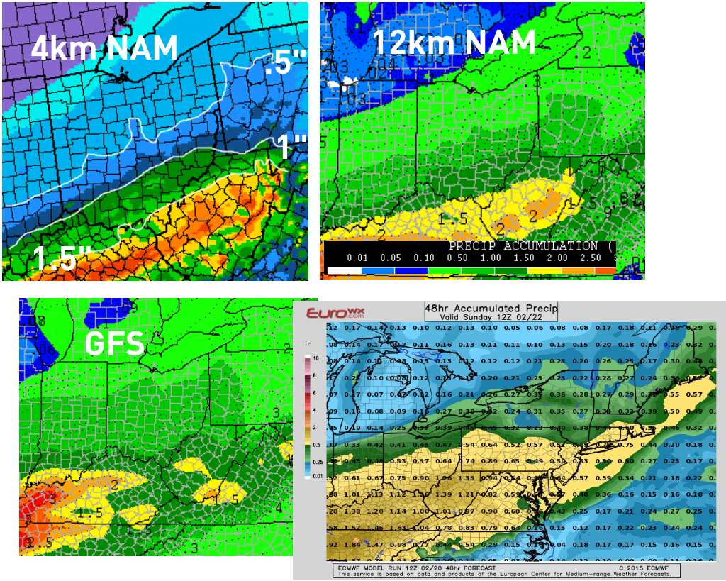
There are some differences in the models, with the NAM showing mainly snow for almost all of southern Ohio and more liquid equivalent (1-2”) than the GFS, which shows mixing creeping a bit farther north into the state and has less liquid over southern Ohio (0.75-1.25”). So, I’m going to attempt to see how the models are verifying against reality and how they’re trending to determine what kind of solution is more reasonable:

The above loop is comparing the 12z GFS/NAM valid at 0z Friday evening to the 0z meso-analysis. In general, the two models are reasonably close to the intensity of the shortwave compared to the mesoanalysis. The GFS/analysis appear a bit weaker, but that’s more a product of their lower resolution. The NAM appears to be closer to mesoanalyis with heights to the east of the shortwave and really all the way to the east coast. The GFS is a bit too high with heights, which may help explain why the model shows a slightly warmer solution. The mesoanalysis is a little higher with heights than the NAM, but is much closer to the NAM than the GFS.
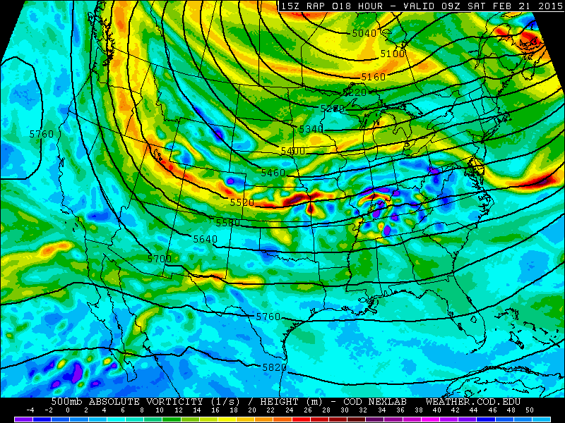
This next loop compares the 15z, 18z and 21z RAP valid at 9z Saturday morning, to see if trends in the short term model can shed any light on the situation. The model has noise level changes in heights east of the shortwave, but on the whole trended a little stronger with the shortwave over the Plains. This could suggest heavier precipitation getting a little farther north over the Ohio Valley when the shortwave comes east due to a slightly stronger shortwave and slightly better southwest flow ahead of it.
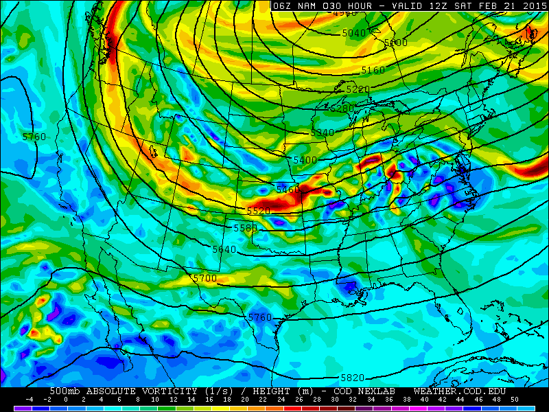
The above loop is a similar look at today’s NAM runs (through 18z). One change is for slightly lower heights over the east, which suggests the NAM may be trying to trend just a little farther south and colder. The shortwave over the Plains also trended a little weaker on the 18z run. This suggests that the NAM’s very high QPF values getting well north of the Ohio River are overdone (not a shock), but also suggests that a slightly cooler solution is possible, which is critical in the southern third of Ohio as temperature profiles are very marginal there. The NAM, interestingly, was cold enough for essentially all snow except for the southern tip of Ohio even with its farther north precipitation shield.

The GFS loop is very interesting. It is extremely consistent with the shortwave, but is consistently trying to depict high heights over the eastern US each run. The GFS is currently the warmest model, but appears to be going against observed heights at 0z and the NAM trend. The NAM appeared to be doing best through 0z.
All told, considering the NAM appears to be correcting a bit weaker with the shortwave, but is otherwise doing well with the height orientation over the eastern US, I’m going to lean towards a GFS/NAM blend for QPF amounts and lean towards the NAM for temps for this forecast. The
Just took a peak at the 0z NAM and it came in with a little less QPF and slightly colder temps.
As for p-type, snowfall placement and snowfall amounts, let’s dive in!

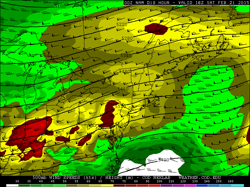
There will be very impressive upper level divergence across the Ohio Valley thanks to two jet streaks working in tandem. We will be in the right-entrance quadrant of a jet streak to our north, and the left exit quadrant of a jet streak to our south, with clear upper level divergence on the image above. Note how the wind barbs “fan out” over the Ohio Valley…also note how there are two areas of stronger winds splitting apart. This indicates strong large scale lift across the region for much of the day Saturday.
At the same time, a decent little speed max at 500mb with the vortmax/shortwave moving across the Ohio Valley will also cause a period of increased lift as it moves overhead. Decent lift at 500mb appears to occur off and on from late Friday night through much of Saturday afternoon. Check out the 500mb vertical velocities associated with this feature:

There appear to be two waves of precip. The first wave is associated with strong 500mb vertical motion (left) early Saturday, with the second one just a little farther south for Saturday afternoon.

Looking into the low to mid-levels, a very impressive jet will transport copious amounts of warmer/more moisture laden air northward into the Ohio Valley ahead of the surface low pressure. The nose of a very strong jet at 700mb will move into southern and central OH late Friday night into early Saturday. There will likely be an intense period of precip that yes is convective as that noses in. The stronger 700mb winds shift south towards the Ohio River by Saturday afternoon, however there should still be some warm-air advection and hence lift at that level across far southern (especially SE Ohio) Saturday afternoon, which along with the aforementioned upper level support suggests moderate to heavy precip continuing in this area Saturday afternoon. The initial surge of warm air advection at 700mb should get far enough north for a burst of moderate to heavy snow as far north as US 30 Saturday morning and light to perhaps moderate snow as far north as Lake Erie, especially east of Sandusky.
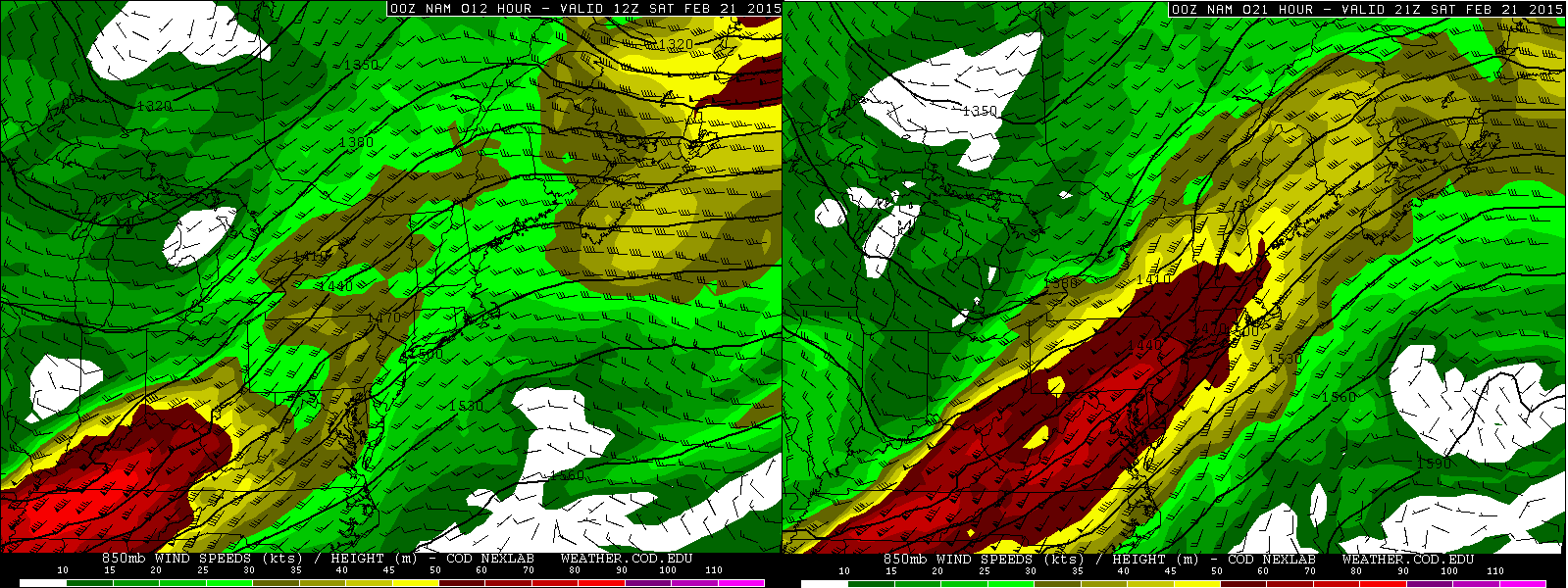
Looking at the 850mb level, there is a very impressive low level jet here transporting in warmer and more moisture laden air into much of southern and eastern OH. The nose of the 850mb jet corresponds to both the nose of the 700mb jet and the first surge of 500mb lift Saturday morning…the stars are aligning for a burst of heavy precipitation in southern/central OH Saturday morning. Even through Saturday afternoon, the northern portion of the low level jet should continue to supply some boost to the precipitation over southern and eastern Ohio, although not to the extent it will in the morning.

When looking at another product at 850mb, theta-e, which is a product of temperature and water vapor, is increasing markedly across southern Ohio on the nose of this low level jet. Warm air advection naturally features rising motion, and as this warmer/higher water vapor content air converges on the nose of the low level jet, it is forced to rise quickly and produce clouds/precip and in this case potentially heavy precip.
Over southern and central Ohio, there is a good signal from everything discussed above for a burst of heavy precip that lasts a few hours Saturday morning. Given the strength of the low level jet and likelihood of slantwise instability, elevated convection is likely. Maybe a rumble of thunder?? Precip rates of 0.1-0.25” per hour will likely occur for a time with this burst, especially in southern Ohio. As we head into the afternoon, the low and mid level lift weakens some or shifts southeast a little, which should cause a bit of a lull in the precip, especially in central and northern Ohio. Closer to the Ohio River, moderate to perhaps heavy precip should continue through the afternoon.
By mid to late afternoon I expect another surface of better precipitation as a few things happen…the vort max moves across Ohio, we get back under the right-exit quad of a jet streak, and as the surface low/trough passes. This should cause one more uptick across central and northern Ohio. This burst of precip may actually be a little longer lasting and intense in northern Ohio, as the morning burst looks like more of a graze job up there.

There will be a fair amount of Gulf moisture streaming north, with precipitable water values of 0.7” getting to the Ohio River on the 0z NAM by Saturday afternoon. The combination of relatively high precipitatble water values and a good 12-15 hours of decent upper level convergence (it isn’t as favorable briefly around noon across the state, but is before and after) leads me to believe that the high QPF values aren’t unreasonable, especially across southern OH where low level lift will be the strongest for a longer period of time.
The NAM is generally more aggressive than the Euro and GFS with QPF. The GFS and Euro agree well, however what I discussed above does suggest increasing QPF a little bit over the GFS and Euro over central and especially southern Ohio.
How much of this falls as snow?

A warm nose will attempt to move north between the surface and 850mb in the warm air advection during the day Saturday. As it stands now, except for right along the Ohio River, the GFS and NAM appear to keep 925mb temps and 850mb temps below 0C through the duration…except for perhaps a brief warm nose trying to work in at times within 20 miles of the river at 850mb during the stronger warm air advection at that level.

At the surface, temperatures re modelled to rise to above freezing across a good portion of the state, but just barely…generally 32-34 degrees.
The NAM and Euro are both a little colder than the GFS, with a general cooler trend in the models noted today.

In addition, the 21z SREF members for Parkersburg show that except for a couple of members that work in enough warm air aloft for a little bit of mixing during the stronger warm air advection in the morning, almost all members keep the precip type snow until later Saturday evening. The SREF are known for being too far northwest with system, too moist and too warm, so it’s encouraging that most of them keep PKB all snow.
On the balance…with every model keeping low to mid level temps at or below freezing (except for the GFS which warms by evening) for all areas just north of the Ohio River through the heaviest precip…aside from perhaps a brief warm nose at times at 850mb near the river…the recent cooler trend in the models…and the likelihood of convective precip which suggests dynamical cooling during the heavier precip rates helping the process…am going for mostly snow more than 10-20 miles north of the river, with a mix and less snow very close to the river.
As for amounts, ratios will not be great across much of the state due to a narrow dendrite growth zone and a fairly deep near freezing layer from the surface up to about 5,000 feet…along with the potential for surface temps to rise to 32-34 during the snow across much of central and southern Ohio. Ratios across northern Ohio of 10-12:1 seem doable, 8-10:1 in central Ohio, and 7-9:1 in southern Ohio. There will be impressive lift in the rather thin dendrite growth zone so flakes probably won’t be small, however the deep layer of near freezing temps make me very hesitant on higher ratios.
With good agreement on a quarter to half inch of QPF across much of northern Ohio, to go along with decent upper jet support and some modest low to mid level lift at times during Saturday, believe 3-6” seems reasonable here. The best chance for 5-6” will be near and south of US 30 where strong mid-level lift may cause a fairly decent burst during the morning. In central Ohio went with slightly higher QPF than GFS/Euro and figured half to three quarters of an inch given a good shot of moderate to heavy precip during the morning and another couple or few hour shot of moderate precip mid to late afternoon. This gives 4-8” of snow here. In southern Ohio I expect over 1” of QPF south of a CVG-RZT (Ross County)-HLG (Wheeling) line, with around 1.25” near the Ohio River east of HTS. This axis of 1”+ QPF matches with where at least moderate precip may not stop during the afternoon, and the heavier amounts near the river correspond to where the strongest low to mid level lift will persist during the afternoon. This QPF distribution is essentially a NAM/GFS blend in southern Ohio.
With very wet snow but mainly snow, this supports a corridor of widespread 6”+ amounts to locally 10” south of a Hamilton-Circleville-Wheeling line…I expect mainly or all snow here and over 0.75” of QPF. Along the Ohio River, will go less as I do believe that enough of a mid-level warm nose will be present to cause frequent mixing here.
This will be a very high impact storm over southern Ohio due to the heavy wet nature of the snow making it difficult for crews to clear the roads. Areas that see over 6” of this snow may see a few trees down and isolated power outages.
