
General discussion:
It is the weekend which means another winter storm is a forgone conclusion across Ohio…
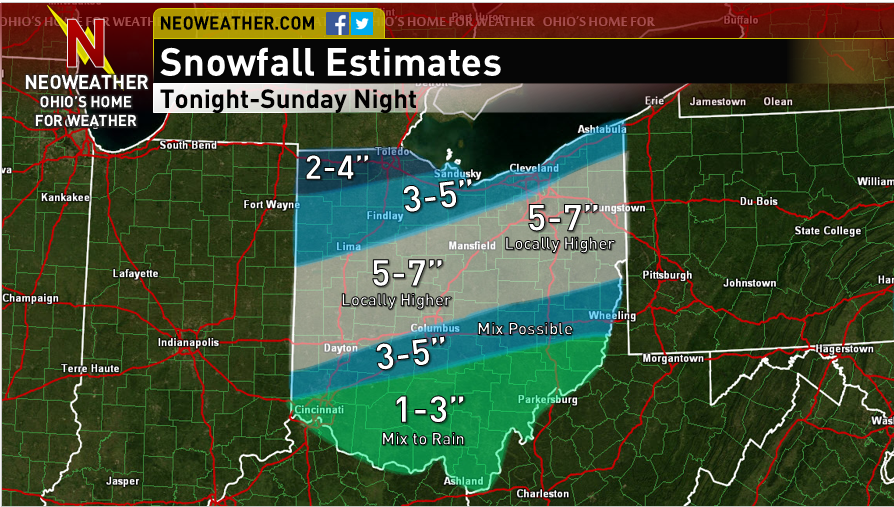
Snow will spread into the state rather quickly between 11PM and 1AM tonight. This first wave of snow will persist into Sunday morning with moderate snow at times. During this wave of precipitation, a warmer tongue of air will likely allow for a mix with sleet or freezing rain as far north as I-70…it should be all snow farther north.
There will be a bit of a break in the snow late Sunday morning and early afternoon before another wave of precipitation moves into the state. This second wave will likely fall as rain south of I-70 (or very wet snow near I-70) and snow farther north. Temperatures could warm above freezing as far north as Mansfield, Akron and Warren so this second wave of snow will be much wetter even in northern Ohio which may limit how quickly it can accumulate. This second wave of snow northern Ohio and a mix or rain south will likely persist through Sunday evening before ending.
All told, a swath of accumulations of around 6″ with locally higher amounts is likely where all snow falls…with slightly less right up against Lake Erie where less precipitation will fall. There will be a sharp cut-off in snow amounts south of I-70 due to southern Ohio seeing a prolonged period of rain instead of snow. Travel will be slick at times across the northern 2/3rds of Ohio late tonight through Sunday before gradually improving Sunday night.
Abbreviated Meteorological Reasoning:
After the models sunk south a little bit on Friday, the trend since the 0z Saturday runs has been to drop the shortwave in the Plains in ever so slightly farther west, which allows for slightly higher heights and a better SW flow aloft over the lower and eastern Great Lakes. The majority of the 12z models have responded by beefing up the area of 0.50″+ QPF and bringing the higher QPF a little bit farther north in general than they were on Friday. The Euro, UKMET and SREF mean (when taking out the ARW core) have been most consistent with the placement of the QPF while the CMC has been consistently too far south, the NAM has waffled (and is currently higher than most other models) and the GFS was generally a little too far south but has trended north today.
There are two clear waves of better precipitation expected with this system. Wave one spreads in quickly from west to east between about 11PM and 1AM and persists through early to mid Sunday morning. There is then likely a break or slackening of precip rates for a few hours late Sunday morning into early Sunday afternoon, before wave two moves in late Sunday afternoon into Sunday evening before tapering. Both waves will be primarily focused by warm-air advection between 700mb and 500mb and some PVA with light to moderate precip rates. Wave one looks to hit all of the state fairly well except for NW Ohio…wave two may be focused a little bit inland from Lake Erie. Due to reasons discussed below it wouldn’t surprise me if wave one does much better than wave two in terms of accumulations.
Much of the state should start as snow, however a warm nose is evident at around 925mb on the GFS/NAM/Euro all the way up to near I-70 or even a little farther north in the eastern half of the state late tonight into tomorrow morning. Surface temps will still be below freezing at this point, but the warm layer could be enough to cause a mix with freezing rain or sleet for a few hours in this area. The lift in the low levels and precip rates in general won’t be as impressive as last Saturday’s storm so I don’t expect dynamical cooling to save the day like it did last weekend all the way down to Cincinnati. Behind wave one, warmer surface air will likely move into the state with the low level southerly winds. Again, dynamical cooling likely won’t compensate as much as it did last week and air temps in the mid 30’s could get close to I-70 east of Columbus by Sunday afternoon and surface temps above freezing could get to route 30 or even a little bit farther north. This will likely significantly limit additional accumulations Sunday afternoon and evening near and definitely south of I-70 and may put somewhat of a damper on things as far north as US 30 Sunday afternoon. Temps do cool pretty nicely later Sunday evening but the better precip pulls out at that point, so the bulk of the accumulations along and south of I-70 should come from wave one.
As for actual accumulations…there is excellent agreement on about 0.5-0.7″ of QPF across much of the state, except a little less close to Lake Erie and in NW Ohio and across far southern Ohio. Looking over forecast soundings across the northern third of the state during wave one, the DGZ is rather thin, but there is lift in the DGZ and also a fairly deep isothermal layer near -10C with decent lift in that deep layer through wave one, which should be enough to get better than 10:1 ratios with wave one across the northern third of the state. With warming low to mid levels am expecting near 10:1 ratios with wave one once you get too far south of US 30. The low and mid levels warm a bit further even across northern Ohio which should cut ratios there for wave two down to closer to 10:1. However, average ratios for the event north of US 30 should be better than 10:1, so I followed an average of the ECM/SREF mean (minus the ARW core) 0.5″ QPF line for the separator between 3-5″ and 5-7″ of snow. The 5″ line as drawn also fits nicely with where the heavier precip from wave two should fall. While the NAM, some SREFs and the NMM both spit out a corridor of 0.7-0.8″+ of QPF just north of I-70, due to warming surface temps during the second part of the storm limiting how effectively new snow can accumulate I’m just not confident enough to go with more than 7″ of snow on my map…will mention “locally higher” amounts but leave the range at 5-7″. Amounts taper fairly quickly south of I-70. Near I-70 including Columbus much of wave one should be snow with perhaps a little mix early Sunday so there should still be a few inches…but mixing will significantly cut into wave one accums farther south, and wave two should fall as rain in much of southern OH, so showed a sharp cut off in snow accums just south of I-70 (as there often is).
