
General Discussion:

Light snow will overspread Athens around noon on Monday. The potential exists for a few hours of somewhat heavier snowfall during the mid to late afternoon, with light snow then persisting through Monday evening. The snow should end after midnight Monday night. The snow will be fluffy and accumulate fairly efficiently, however the somewhat short duration of heavier snows makes it uncertain whether or not more than 6″ can fall. Winds will generally be light, so blowing snow shouldn’t be a large concern.
Detailed meteorological reasoning:
After the vast majority of chances for heavy snow for Athens and SE Ohio have missed to the north, south, or just disappeared so far this winter, it appears that a shot of moderate snow may finally affect the area Monday into Monday night.

A shortwave is diving southeast through the Rockies this afternoon, with some moisture bring drawn eastward from a cut-off low over the Baja of California. With a rather flat shortwave ejecting into the Plains tonight into Monday and a very strong Nor’easter currently acting to cause lower heights along the East Coast and strong confluence aloft over the Ohio Valley and southeast, the main concern for Southeastern Ohio won’t be if the precipitation will fall as rain instead of snow, but more along the lines of how far north the heavy snow with this storm can make it.
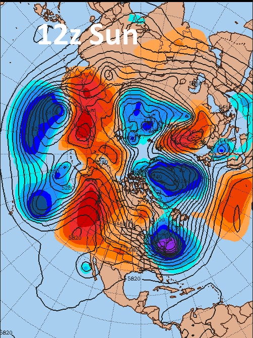
When panning out to the entire hemisphere now, there is some hope for the mess off the East Coast to get out of the way. There is no –NAO, in fact it is strongly positive due to lower heights over Greenland and Iceland. There is still plenty of room for the Nor’easter to swing out well to the northeast over the next day, and in fact when comparing the map from 12z/8AM Sunday for the hemisphere to the closer in map from 20z/3PM of the US, you can see that the trough with the Nor’easter has already swung off the New England coast, with heights rapidly riding to the west.
Considering the lack of a –NAO, it is not surprising that our models went from keeping any snow well south of Ohio to trending north and threatening to bring decent snows to Athens as soon as the shortwave responsible was sampled by RAOBs over North America…it is not uncommon for these pieces of energy to come in a little stronger than thought compared to when they’re out over the Northern Pacific where there isn’t as much good data going into our forecast models.
The ridging on the West Coast is also very stout, which does suggest our shortwave digging a good amount and potentially partially phasing with the sub-tropical jet before ejecting out into the Plains tonight into Monday.
So yes, the models have trended north a fair amount over the last 24-36 hours with respect to the track of the surface low and precipitation field, and most do show at least some accumulating snow for Athens. However, it is important to figure out exactly which models are right, if there will be another trend back north or perhaps a bump south, and what kind of snowfall amounts the dynamics with the storm system suggest could happen.

First I am going to compare the 12z runs of the GFS/NAM valid at 21z this afternoon to the 21z mesoanalysis using 500mb height/vorticity. In general, the 12z GFS is closer to reality than the 12z NAM. The GFS is very close to the analysis with heights over the eastern US, and is a little less amplified with the shortwave diving into the southwest US. The NAM is both too slow to move the Nor’easter off to the east and hence too low with heights over the eastern US, and also not digging the shortwave quite far enough southwest over the western US. One interesting note is neither model is quite strong enough with the little vortmax over Minnesota, which could make a small difference later.

Although the “long range” RAP (towards the end of the run) shouldn’t really be used for a deterministic forecast, trends in the RAP as it gets closer to verification time can potentially shed light on how the model is handling a situation. I’ve compared the 12z, 15z, 18z and 21z RAP runs valid at 6z Monday at 500mb in the animated GIF above. Note how the 12z run was definitely too slow to eject the eastern US and had heights that were too low over the eastern CONUS…although that generally steadied out or became a very slow trend by the last two or three images. Much like this morning’s models, the shortwave appeared to be modeled to not dig far enough into the SW CONUS on the 12z and 15z RAP…again though, the last two runs were much closer together. The small feature over Minnesota discussed above is expected to be over Lake Superior tonight, and it should be noted that there was a slight trend to move that feature farther south on the RAP as we get closer to verification time…which could make a very small difference in the heights across the Great Lakes.
Because the differences between RAP runs is decreasing as we get closer to verification time, I believe it is fair to compare the 18z GFS/NAM and 12z Euro to the 21z RAP valid 6z Monday to determine if the NAM/GFS/Euro are close to the stabilizing RAP at 6z:

In general, you have to squint to see differences. The Euro and GFS appear to be close to the RAP in terms of how far southwest the shortwave digs over the Rockies. The NAM is similar in height configuration but noticeably farther northeast with the highest vorticity. In the east, the Euro and RAP both appear to be pulling the Nor’easter (based on the 498dm contour) east just a little quicker than the GFS/NAM…which is a trend already noted above. Over the Ohio Valley, the GFS and Euro are a smidgen lower with heights compared to the NAM/RAP.
All together…when considering the pattern (no –NAO supports the quicker exit of the Nor’easter and the very stout ridge along the west coast supports our shortwave digging more aggressively into the SW US before ejecting into the Plains)…and the trend in the models to continually move the Nor’easter east faster…along with the trend (that is starting to end) to amplify the shortwave diving into the southwest more before it ejects…I’d be inclined to believe a south trend is unlikely. The vort max over Lake Superior gives me a little bit of concern, however the GFS/NAM/Euro are currently handling that similar to the recent RAP run. The Euro appears to be leading the way with moving the Nor’easter east (it was much farther north with the storm than the GFS/NAM in last night’s 0z run and stayed very steady in today’s 12z run with perhaps a very small shift south)…and the GFS and Euro appear to be handling the more aggressive digging of the shortwave into the southwest better.
The 18z NAM is fairly close to the GFS/Euro, so I’ll favor a blend of the three models for this forecast. With the Euro appearing to lead the way with the north trend compared to the GFS/NAM, I’ll give its slightly farther north solution a little bit more weight.

When looking at the Euro, NAM, GFS and RGEM (essentially the Canadian version of the NAM, it’s not much worse than the NAM itself), all four models show 0.3” or more of liquid QPF for Athens. The RGEM and NAM appear to be about 0.3-0.4” of liquid, and the Euro about 0.5” of liquid, while the GFS is probably about 0.3” on the dot. Snowfall isn’t model QPF times 10, contrary to the somewhat popular belief (its snow rate times duration), however you can see a few things:
-All four models bring a half decent amount of QPF to Athens
-There will be a fairly sharp northern cut off to the snow
-If the NAM/GFS/RGEM shift any farther north, they could bring “Euro like” numbers to the area.
I have already been naughty and included a couple of Euro images in this write up, so I’ll look at mainly the NAM/GFS to discuss the dynamics of this storm, when it may snow and how heavily it may snow. In general, the Euro is very similar to the GFS/NAM but shifted 25-50 miles farther north.
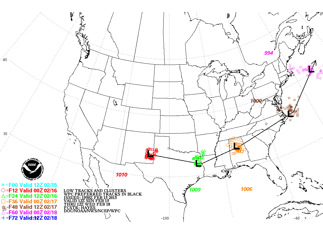
NOAA’s Weather Prediction Center is forecasting a low track across the Deep South, well south of Athens, with most models agreeing on a similar concept per the map above. So, how will we get snow all the way up into Athens with this low track?
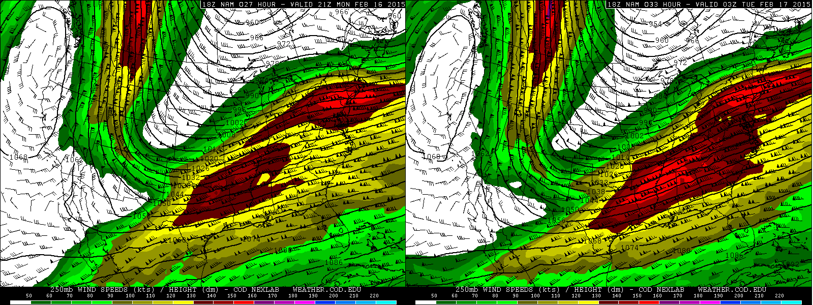
When looking at the jet stream (250mb level) on the NAM, Athens will be in a favorable region of upper level divergence (which is a source of lift) from Monday afternoon into Monday evening. Z time (the time stamps in the upper right corner) is EST plus 5 (Z time is five hours ahead of EDT, so 21z is 4PM EST). Both the right-entrance quadrant of a departing jet streak and left-exit quadrant of a jet streak running to our south will provide large scale lift to the area. This helps explain how there’s a low pressure system running across the Deep South (with the favorable lift on the southwestern side of the jet streak to our south) while there’s snow in the Ohio Valley (with lift from two jet streaks) at the same time.
This period of favorable upper level jet support lasts about 12-15 hours (from roughly late morning Monday till 1AM Tuesday). However, the GFS/NAM show the better mid-level lift staying just south of us, which means we would struggle to see a prolonged period of moderate to heavy snow in Athens.
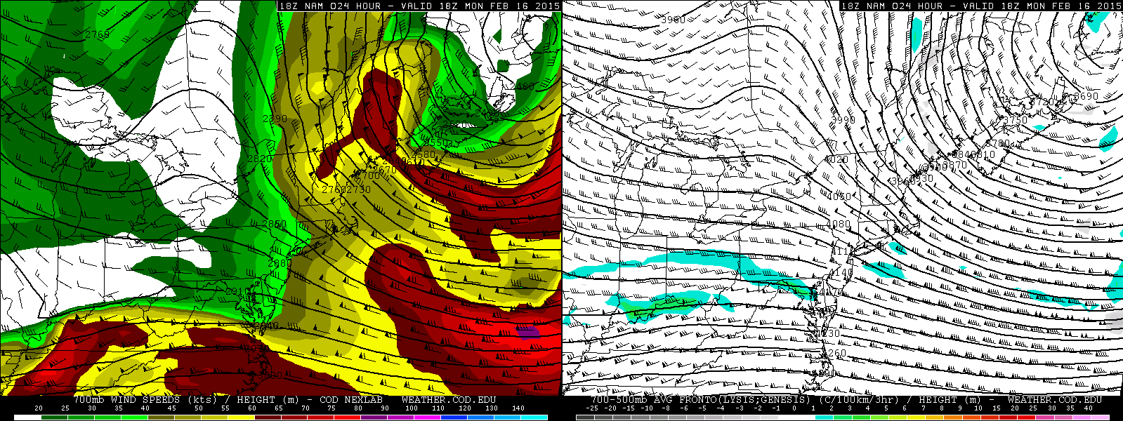
Often times, heavy snow in winter storms comes from warm air being forced to rise over a colder surface airmass and condensing and forming clouds/snow. This process is most effective on the nose of strong mid-level winds that have a southerly component, as those winds are bringing warmer and more moist air farther north. As can be seen on the left plot above from the NAM valid at 1PM Monday (at the 700mb level), the nose of the stronger mid-level winds is just south of Athens. The mid-level frontogenesis plot on the right (which is a good signal for where this source of lift is maximized) does suggest an area of heightened frontogenesis just south of Athens at 1PM. As is, the NAM keeps the heavier snow with this feature just to our south, as does the GFS. The Euro brings this feature slightly farther north over Athens, suggesting we could get into a period of moderate to heavy snow due to being on the nose of a stronger mid-level jet/mid-level warm-air advection IF the Euro is correct.
North of the best mid-level frontogenesis, any snow would likely be caused by lift even higher in the atmosphere:

When looking at the 500mb plots (which is about 18,000 feet above ground level) for Monday afternoon, one can see there is fairly strong positive vorticity advection over southern and central Ohio (vorticity plot on the left). Positive vorticity advection is a source of lift, and the corresponding 500mb vertical velocity plot on the right at the same time does show upward motion where the stronger positive vorticity advection is occurring.
Both potential sources for heavier snows will be strongest Monday afternoon before dwindling gradually Monday evening, which suggests that if we do see heavy snow in Athens, it will be Monday afternoon, with things starting to taper Monday evening and ending after midnight Monday night. The duration of snow looks to again be roughly 12-15 hours, with the period for potentially more moderate or heavy snows being about 6 hours.

Stepping back and taking a bigger picture look at 1AM Tuesday, the shortwave that will be causing this snow will be weak and positively tilted. This suggests that the best sources for lift and hence snow will be positive vorticity advection, upper level jet support and low to mid-level warm air advection…with little wrap around snows. So, we are looking at a 12-15 hour shot of snow, with the best chance for moderate or heavy snow being about a 6 hour window Monday afternoon and early afternoon through early evening, IF the storm can shift north and bring the better mid-level warm air advection closer to Athens as discussed above.
Figuring out when/how long it will snow, how hard it may snow and how much liquid will fall aren’t the only part of figuring snowfall amounts. Snow can accumulate much more efficiently with the right type of snowflakes, which means that one amount of liquid falling as small snowflakes would accumulate much less snow than that same amount of liquid falling as large, fluffy snowflakes.

The most important factors to figuring out what kind of snowflakes will fall are where in the atmosphere will the air be nearly saturated, where in the atmosphere will there be upward motion, and where in the atmosphere the temperatures will be between -12C and -18C (dendrite growth zone).
The plot above for Parkersburg helps us answer those questions. The color fill is relative humidity (bright greens and purples are nearly saturated), the purple and yellow outlines indicate the “dendrite growth zone”, and the red outlines indicate upward motion in the atmosphere. As can be seen above, there is a fairly deep and saturated dendrite growth zone per the NAM over Parkersrburg Monday afternoon and evening, with the strongest lift focused in and above that zone. With cold temperatures at the surface, it is likely that the snowflakes will be fairly fluffy. As is, the plot above isn’t perfect for high ratio snows, but if the Euro panned out, stronger mid-level lift would occur in the dendrite growth zone and lead to higher ratios. Either way, snow to liquid ratios of 15:1 to 20:1 will be likely.
Considering I’m giving slightly more weight to the Euro as discussed above, I am expecting a few hours of moderate snow in Athens mid to late Monday afternoon, potentially into the early evening. Snow rates of half an inch to an inch per hour are possible in this timeframe. There could be a couple hours of light snow before that, and a few hours of light snow after that. This adds up to a few to several inches of snow for Athens. When factoring in snow ratios and modeled liquid equivalent values, amounts range from about 3.5” on the GFS to about 6” on the NAM to about 8” on the Euro. I’m not ready to go “all in” on the Euro QPF due to the quick hitting nature of the storm in general and low precipitable water values. A dry northeast flow ahead of the storm may also eat away at the northern edge of the snows a little bit. However, given a fairly good shot of upper level jet support and lift in upper levels, and the potential for a period of strong mid-level lift and heavier snow if the farther north models pan out, I feel as though a 4-7” snowfall forecast covers the bases well enough for Athens.
