
General discussion:
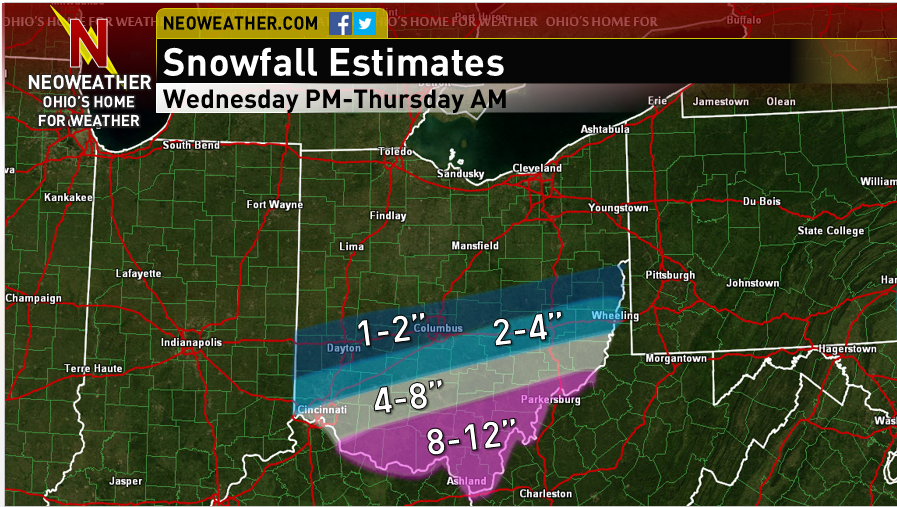
Colder air will pour into Ohio on Wednesday, changing any rain over to sleet and eventually snow from northwest to southeast during the day Wednesday. By Wednesday evening, another surge of precipitation will affect southern Ohio, and this should fall as mainly or all snow. A long duration moderate to heavy snow event is expected which will result in snow totals of up to a foot near the Ohio River. There is considerable uncertainty on the northern side of things (including Columbus) due to a very sharp northern cut off to the heavy snow. Small variations in the forecast could result in much different snowfall amounts on the northern edge of the snow.
Meteorological Explanation:
When looking over the 0z and 12z model runs and observations from this morning, it appears the trend is for a slightly weaker and slower cut-off ejecting out of the southwest, and also the shortwave moving into the Great Lakes on Wednesday coming in a little quicker. This all argues for the heaviest swatch of snow shifting farther southeast. The 0z GFS captured this considerably better than the 0z NAM. Considering the cut-off still isn’t well sampled, and considering CIPS analog guidance suggests it is very difficult to get heavy snow in the Ohio Valley with this setup, I’m expecting an additional slight bump to the south with tonight’s 0z runs…hopefully I adjusted the map far enough south.
As for exact placement of the amounts, the 12z NAM/GFS/Euro all suggest that 8”+ is very likely across much of southern Ohio. Even with an additional bump south on these models, 8”+ would still likely occur along and just north of the river. Although the NAM and Euro (and even the GFS BUFKIT output) along with several SREF members suggest amounts of up to 15” are possible, I believe that these amounts (if they even occur at all) will be just south of Ohio, as this is where the best mid-level isentropic lift is shown during the storm Wednesday night into Thursday morning. In Ohio, there is still tremendous lift from the right-entrance quadrant of a 200+ knot upper level jet streak from Wednesday PM through Thursday evening, along with high PWATs for a winter storm situation (greater than 0.8” Wednesday evening falling to 0.6” by Thursday morning)…this great upper level lift and high PWAT combo when combined with the duration of the snows (12-15 hours in southern Ohio) and improving snow ratios during the second half of the storm suggests that amounts of up to a foot are possible just north of the Ohio River.
There is good agreement among the Euro/NAM in eroding any mid-level warm layer by Wednesday evening across southern Ohio, with the GFS a few hours faster than that. Most SREF members agree…a few members show rain hanging on in southern OH through much of Wednesday night which shows up in p-type probability plots and skews the mean snow down at sites such as PKB and CVG, however, these members show a ridiculously far north and strong storm track and are being discounted. All in all, feel as though a delayed changeover to snow isn’t a large enough risk to cut down on snow amounts much in southern Ohio.
A very strong northern cut-off to the snow is depicted on all models due to very dry air trying to work in from the northwest. The cut-off depicted on this map is if anything less sharp than the cut-off that some models show, which means the northern edge may need additional trimming at some point between now and when the snow starts if the models continue their south trend. As for the northern edge of the higher amounts…I was very conservative due to the expected sharp cut off, the best mid-level lift staying south of the river and the expected further bump to the south.
