
Model images in this post came from:
weatherbell.com, tropicaltidbits.com, weather.cod.edu, instantweathermaps.com and the University of Berlin’s Atmospheric Diagnostics website.
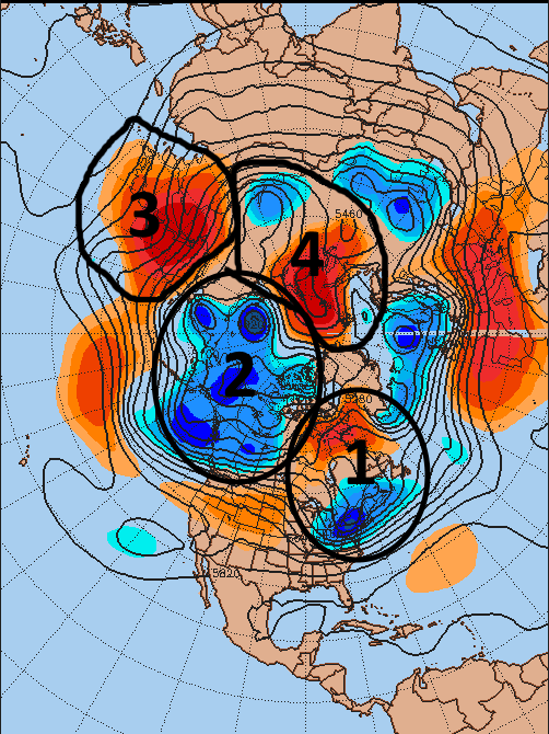
A brief cool down is occurring in the Northeast US, with some lake effect snow, after another good shot of mild air across much of the central and US this past week. This cool down is the result of an upper trough associated with a storm that brought severe weather to the Midwest moving east, and being slowed down by a transient west-based –NAO (1).
This pattern will not last long, as the very large trough (2) centered over Alaska is sending another very potent shortwave down into the western US this weekend. This shortwave will phase with the sub-tropical jet and produce another large storm in the central US during the first half of this upcoming week, with heavy rains, gusty winds, severe thunderstorms and backside snow all threats somewhere with it. This recent pattern of frequent troughs dropping into the west has been very good for ski resorts out there, and they need it in the worst way after the last few winters.
Other features of interest over the next couple of weeks that are currently on the hemispheric map will be a strong jet over Asia and the western Pacific (3) that will attempt to coax ridging up towards Alaska and dump cold into Canada and the central US, and a potentially favorable look (4) for a later winter –AO developing over Siberia.

Ok, so let’s start diving in now. As we head into the work-week, more heavy western US snow is likely as another very potent trough dives into the Four Corners region. Although a west based –NAO exists, short wavelengths allow for ridging to build between the western US trough and the “50/50 low” near Newfoundland. This allows for the eastern US to quickly forget about the current chill, and allows quite a stark temperature gradient to develop across the central US as this large trough ejects out of the southwest.

The result of this trough is the polar jet phasing with the sub-tropical jet and causing a respectable jet streak to eject out into Texas Monday into Tuesday, with a stout temperature gradient over the Plains. The wavelengths are shorter than typical for mid-November and are allowing for a very meridional weather pattern to develop over the US this upcoming week:
The strong jet streak, strongly curved flow with the trough and strong temp gradient over the Plains results in yet another deep surface low developing over the Plains Monday into Tuesday and slowly moving northeast. The strong pressure gradient between the deepening surface low over the Plains and a fairly large high over the eastern US results in a large area of prolonged and strong southerly flow ahead of the surface low, advecting quite a bit of warmth and moisture north ahead of the low:

The GFS has a swath of 1.3” PWATs getting into the Great Lakes and 1.8” PWATS getting close to the Ohio River…both of which would threaten record high PWATs for the time of year. The closed off nature of the upper trough as it moves across the Plains this week, very moist air ahead of the system and a strong low to mid-level flow will result in a potential swath of significant rains across parts of the Plains east into the Mississippi Valley and potentially the lower Ohio Valley. In addition, strong wind shear and a relatively warm/moist airmass could result in severe weather threats across the southern Plains on Monday and potentially farther east and north on Tuesday. On top of the rain/severe threats on the warm side of this system, there will be enough cold air on the backside of the system for snow. The slow moving nature of the storm combined with the strong nature of the storm could result in a blizzard across parts of the Rockies east into parts of the Plains. The GFS has trended faster (and towards the Euro) recent runs which has caused it to cut down snow totals in the Plains, but this could still be enough to have an impact on the backside of the low:

In the grand scheme of things, the bigger impact this system may have on the overall pattern is to possibly (like the storm that recently moved through the Midwest and Great Lakes) coax a negative NAO by next weekend:

The prolonged and strong warm air advection ahead of the storm as it slowly moves across the central US will cause heights to rise across the eastern US and Canada, and as the trough over the central US comes east it may try to undercut the ridging over eastern Canada and cut it off, causing a –NAO to form. The 12z Euro ensembles showed this occurring emphatically, and had strong agreement from the operational version of the model:

The significance of this –NAO, even if it only lasts for a few days, would be to potentially help cold air move farther east in the US as the Pacific pattern becomes more favorable over the next 7-10 days. The 18z run of the parallel GFS ensembles (which will allegedly become operational in December) attempted to develop a –NAO like the 12z European suite, but didn’t quite get there:
Yes, the ensemble did show a significant height rise into the Davis Strait and Greenland, and if this occurred it would probably cause the numerical values of the NAO to be negative…however, this type of setup is rather transient looking and wouldn’t be as helpful as a European type solution. Note how the ridge into Greenland is more of a thumb ridge extending up from the US East Coast, as opposed to a blocking ridge, with the negative height anomalies south of the low well off the East Coast (as opposed to closer to Newfoundland). Here’s what the 18z parallel GFS ensembles looked like a couple of days later:

Although yes, positive height anomalies persist in the NAO domain and yes, this North Atlantic pattern wouldn’t be a negative for cold over the eastern US, you can see that again it’s just a thumb ridge extending into Greenland, which may not to a whole lot to slow down troughs over the eastern US and allow them to dig, which is what a classic –NAO does.

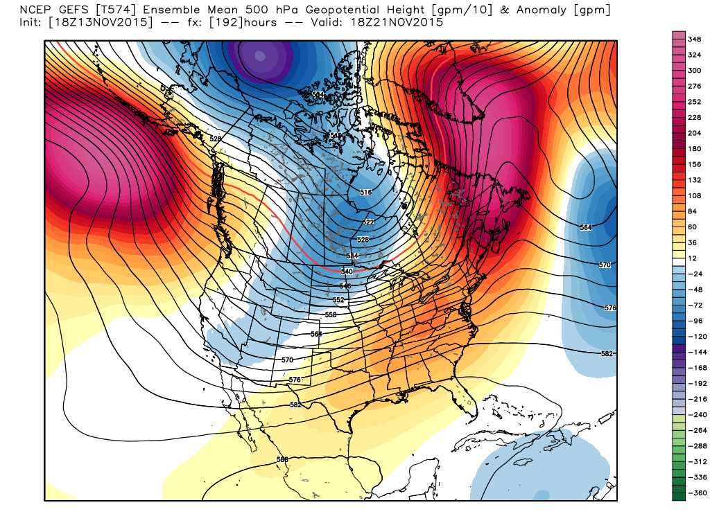
The 12z European ensembles are marginally better at day 10, with an independent ridge over Greenland/the Davis Strait (NOT a thumb ridge extending north from the mid-latitudes). This block isn’t the strongest, but would in my opinion be a somewhat better North Atlantic look than the 18z GFS ensembles. What the Euro ensembles do that is very interesting is begin to develop a “ridging over the top look” with ridging into Alaska and Greenland, with troughing underneath across the US. This would be a good looking pattern for below to potentially well below normal temperatures in a good portion of the CONUS Thanksgiving week.
The 0z Saturday operational GFS trending significantly slower with the Plains storm this week (like the Euro), and came in with a better –NAO next weekend than previous runs. We’ll have to see if the ensembles and future runs continue to support this idea, however it may not be a coincidence that the GFS trended more towards the Euro with the central US storm and conversely trended toward the Euro’s stronger –NAO idea:

The ridging along the East Coast isn’t optimal, but a closed off 573dm contour near the southern top of Greenland with an upper low pinned south of that ridge is a pretty solid –NAO.
A huge key to the potential cooldown Thanksgiving week that both sets of ensembles are at least hinting at above is ridging developing in the NE Pacific and nosing into Alaska, allowing cold air to start filling up in Canada and potentially moving south into the US.
If you read my post last week, you remember that I discussed the ensembles retracting the Pacific jet before Thanksgiving, which supports ridging in the NE Pacific and a cooler CONUS weather pattern. However, I was struggling to find irrefutable evidence that the jet retraction would occur long enough for ridging to develop where we want it to for cold in the US, and at that time the ensembles were not emphatic about above developing the ridging. I did go for at least seasonable to somewhat cooler weather in the central and possible US for Thanksgiving week and suggested I’d have a better feel for that this week. And at this point I’m more optimistic for a few reasons.
One reason I’m more optimistic is the GFS and European ensembles have consistently, run after run, shown the jet retraction beginning to occur next week and persist through much of Thanksgiving week. They began hinting at this in their Thursday, November 5th runs (at least that’s when I picked up on it) and HAVE NOT WAVERED in the jet retraction. It is a good sign when the two top medium range ensembles in the world do not waver on such a major idea for so long.
The reason this jet retraction is important is because divergence in the left-exit quadrant of the jet supports storminess and lower heights; this puts lower heights near or west of the Aleutians, which puts ridging over the NE Pacific due to mass transport of warmer air north to the east of a trough and general storminess. This ridging is key to cutting off the flood of mild Pacific air into the continent and allows Canada to become colder, which makes it more likely for truly cold (not just these come and go marginal cool shots we’ve been seeing the last month or so) to try to move south into the US if there’s a mechanism to bring it south.
One reason I’m more confident in the NE Pacific ridging develop within a week and persisting through Thanksgiving week is there’s now a more clear signal for the jet retraction to even occur. It’s not just ensemble voodoo at this point.

Part of the reason appears to be Indian Ocean convection remaining very persistent over the last few weeks, and likely persisting for at least the next week to 10 days. The Indian Ocean convection appeared to have possibly suppressed the El Nino related enhanced convection for a couple of weeks, rather unexpected for such a strong El Nino, although some convection is returning to the Tropical Pacific. As long as the Indian Ocean convection persists and the El Nino convection doesn’t get too strong too far east (which it right now isn’t, it’s strongest near the International Dateline which is decent), the enhanced Asia jet idea and weaker eastern Pacific jet remains on the table.
The reason the enhanced Indian Ocean convection persisting appears to be important is it likely helps re-enforce a rex block over eastern Asia that is pinnacle to the strong Asia-west Pacific jet:

The enhanced Indian Ocean convection strengthens the jet over western Asia, which keeps storminess and lower heights over north-central Asia, beneath a Barents-Kara Sea high. The lower heights over Asia, possibly bolstered by strong radiational cooling due to above average snow cover in Siberia, contribute to a very strong pressure gradient over SE Asia which results in the enhanced jet here. The GFS and Euro and both sets of ensembles agree on the idea, and tropical forcing seems to support it, so I’m becoming rather confident the jet retraction will occur.

One possible concern would be increasing Pacific convection causing the jet retraction to struggle to realize itself. At this point, the most persistent convection is located along the Dateline, which is near the latitude of the Aleutians…strong convection here wouldn’t affect the jet retraction. I think at this point the Asian pattern is locked and loaded for a very strong jet over Asia and the western Pacific, which should cause the jet retraction and attendant NE Pacific ridge to occur regardless. A flare-up of convection farther east in the Pacific may just bring an end to the pattern by early December. We’ll see. The GFS and Euro are both hinting at a recurving typhoon in about 10 days which could bolster the pattern and allow favorable Pacific ridging to persist into the first week of December.
How strong the NE Pacific ridge gets will be interesting. It continues gradually trending stronger on the ensembles, and the 0z op Euro just came out with enough ridging to actually facilitate a cross-polar flow into central Canada, which would allow some true arctic air to possibly come into the equation Thanksgiving week. It’s one op run…but something to watch if the trend for a more amplified NE Pacific ridge continues:

Given all of this, here is my forecast for the next three weeks:
November 16-22: Starts mild in the east and cold in the west. A strong storm brings heavy mountain snows to the west, possible snow to parts of the central Plains, heavy rain to the Plains, Mississippi Valley and Ohio Valley, severe weather in the southern Plains and possibly east towards the Mississippi Valley, and warmth to all of the eastern half of the US for a few days. Cooler behind the system across the Midwest, Great Lakes and possibly New England late this week into next weekend.
November 23-29: Increasing evidence of cold centered in the central US; possible that troughs still dive into the Rockies as the Euro shows, allowing for colder than normal conditions here too. Eastern US call is tougher and more NAO dependent, however I have to believe a gradient pattern may develop where New England is colder than normal, the Mid-Atlantic is near normal and the SE is warmer than normal. It’s possible that true arctic air is tapped this week, which would most likely dump into the central US by Thanksgiving, possibly setting off major lake effect snows. A gradient pattern…with the heart of the cold dumping into the central US…could possibly support some sort of synoptic snow from parts of the southern Plains east across the Ohio Valley, Great Lakes, Appalachians, interior Mid-Atlantic and New England. Where exactly this occurs (or if) is highly dependent on if we can pull off a –NAO, and if Alaskan ridging can build enough to tap arctic air. Neither is a certainty, so the prospects for potential well below average temps in the Midwest and a possible snowy system are uncertain but certainly non-zero.
November 30-December 5: This may be when El Nino starts flexing its muscles again. I suspect this week could end up below normal across the east, but we may see a Gulf of Alaska low start to return, starting to flood the western and central portions of the continent with milder air.
A word about the stratosphere (since I said last week I’d try to mention it this week):

A part of my winter outlook was October snow cover advancing faster than normal across Eurasia, possibly supporting a second half of the winter flip to a –AO per research done by Dr. Judah Cohen. Let’s check on the steps so far:
- Siberian snow cover advanced faster than normal in October.
- Snow cover induces surface cooling:


Both the GFS and European (shown) ensembles have higher than normal surface pressures over Siberia over the next week to 10 days, corresponding to strong radiational cooling in this area. Step 2 appears to be getting underway on schedule.
3) Tropospheric jet amplifies, enhances polar heat flux/vertical wave propagation:
As discussed above, the tropospheric jet is amplifying south of the Siberian cold over the next week to 10 days, supporting our pattern change! Ridging on either side of the Siberian block could qualify as enhanced polar heat flux if they persist/occur as currently forecast, which may allow vertical wave propagation into the stratosphere to begin occurring:

It’s also not impossible that if a strong –NAO develops it also upwells a bit into the stratosphere.
The GFS and Euro both appear to attempt to start upwelling some warmth into the stratosphere in the long range, although it should be noted this is still fairly far out, and would need to persist to be of help for our later winter AO state:

The Euro (shown) and GFS both have warming beginning to become evident, especially between 20mb and 70mb by 10 days from now over the northern Pacific, possibly related to the aforementioned Asian and Pacific pattern. This would need to persist to really alter the stratospheric vortex and possibly coax a –AO maybe in January, because the +QBO base state combined with the very very strong polar vortex as is will attempt to fight off any attempts at warming:

The 1mb polar vortex is very strong and well organized for mid-November. We’ll need to attack that moving forward.
One more encouraging sign, besides the Asian pattern seemingly trying to follow Cohen’s SAI theory model, is this difference map I threw together just for shits. I simply took Novembers that proceeded a +AO winter since 2000 and subtracted them from Novembers that proceeded a –AO winter since 2000 to see what differences in the pattern were evident across Asia:
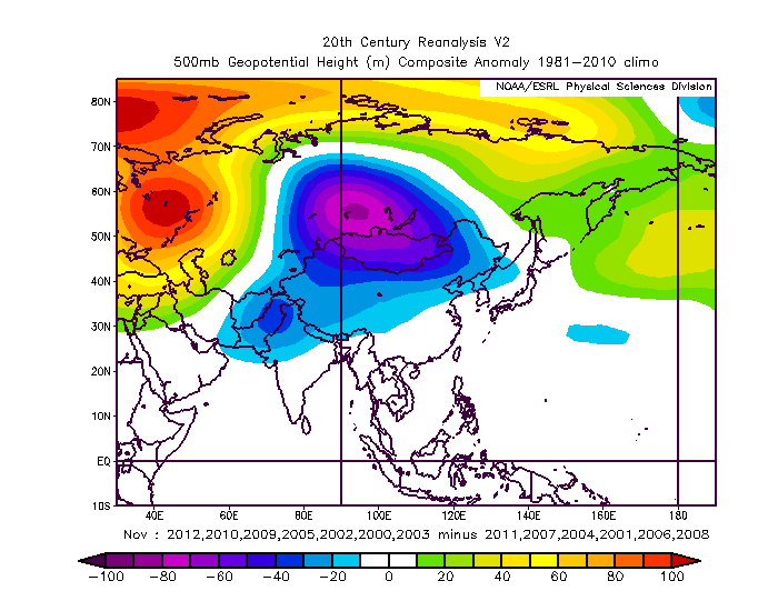
It’s important to note that these years only looked at winter AO and the November 500mb heights over Asia, and ignored all other factors. But, it’s interesting that lower heights over central and eastern Asia with higher heights over the top across the Barents-Kara Sea in November occurred in months that proceeded –AO winters when compared to months that proceeded a +AO winter.
Anyways, I really need some rest, so that’s all for this post. I think I gave you enough to chew on for a little while.
