
I *finally* got around to putting numbers on my map and tweaking things.
Unfortunately, I definitely had to lower amounts from my initial thinking. The models all converged on a solution that was weaker with the storm, which allowed drier air to move in quicker. Of course, the Euro showed this solution two days ago, and I wrote it off since seemingly every other model disagreed with it. I’ve found that when I disagree with the Euro it usually pulls off the coupe, so maybe I should stop doing that.
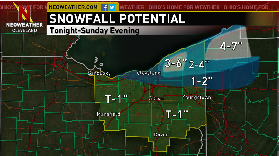
The winds will be WNW late tonight into Sunday morning, and moisture looks pretty good through tonight, so I do think that there’s an initial burst late tonight into Sunday morning. Instability will be extreme by this point too. It still looks like things may get disrupted for a few hours Sunday afternoon as a little wind shift moves through, but we should see another increase Sunday evening as ridging over land causes convergence to increase over the Snowbelt.
As for amounts, instability is still going to be extreme and although moisture actually looks pretty marginal now, we do still have a long fetch working for us and the potential for some convergence over the Snowbelt to try to help focus things. Winds do look to go to a more true WNW direction which should try to push things into northern Lorain and Cuyahoga Counties, so I kept the idea of light accumulations there. The window for that looks to be a few hours long late tonight into Sunday morning, and with more questionable moisture I decided to only go with 1-2″ there. We’ve seen bands in this area surprise with a WNW flow before, so I suppose it’s not impossible someone gets 3 or 4″ in northern Cuyahoga County (outside of the far east side where I have it drawn in), but it’s not likely. I overall decided not to shift the area of heavier amounts much farther south in the heart of the Snowbelt compared to my first guess. There will be a pretty strong lake-land temp differential, which should create a pretty decent lake aggregate trough and tend to try to keep snow a little closer to the lake. With two potential windows for banding along with extreme instability and a long fetch, I still think a few or several inches could fall, but think amounts should stay under 6″. Confined the heaviest accumulations to the higher terrain.
Hopefully we get a more legitimate event soon!
