
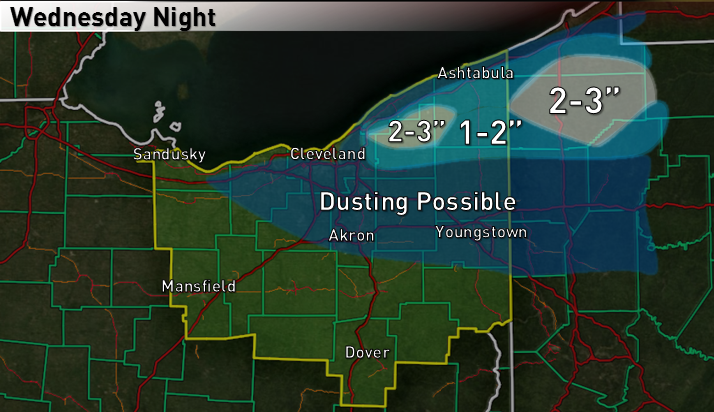
Accumulation map. Confidence: Lower than preferable
Although I’m not sure how much snow ultimately falls due to marginal temperatures, we’ve had a slow start to the LES season in NE Ohio, so I’m going to do a write up on this event.
Aloft, a closed off upper level trough will move right over Ohio Wednesday night, with strong height falls, a good shot of PVA and deep moisture. The upper trough will also bring colder mid-level temperatures and a surge of colder air at the surface behind a secondary cold front that will move through early Wednesday evening, which will allow some lake induced instability to develop Wednesday night in combination with synoptic lift and deep moisture.

As the upper trough moves overhead Wednesday evening, the models are in good agreement on an inverted trough in the low-mid levels developing across Lake Erie into extreme NE Ohio and into northern PA. The models have come into agreement on perhaps initially lifting this trough across the Cleveland metro early Wednesday evening, before lifting it northeast a tad over the primary Snowbelt and then swinging it southeast early Thursday morning as the upper low begins pulling away and winds turn more NNWrly. The area where this inverted trough “pivots” (somewhere over far NE Ohio or perhaps NW PA) will likely see the most prolonged period of moderate to heavy precip, and will likely see a good amount of QPF…the question will be how much of this falls as snow.
There appears to be good potential for heavy precipitation where this inverted trough sets up Wednesday evening due not only to lake enhancement but also due to good synoptic moisture and non-lake effect related sources of lift.
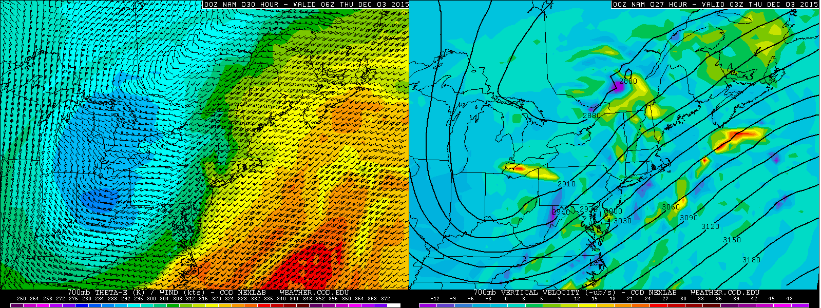
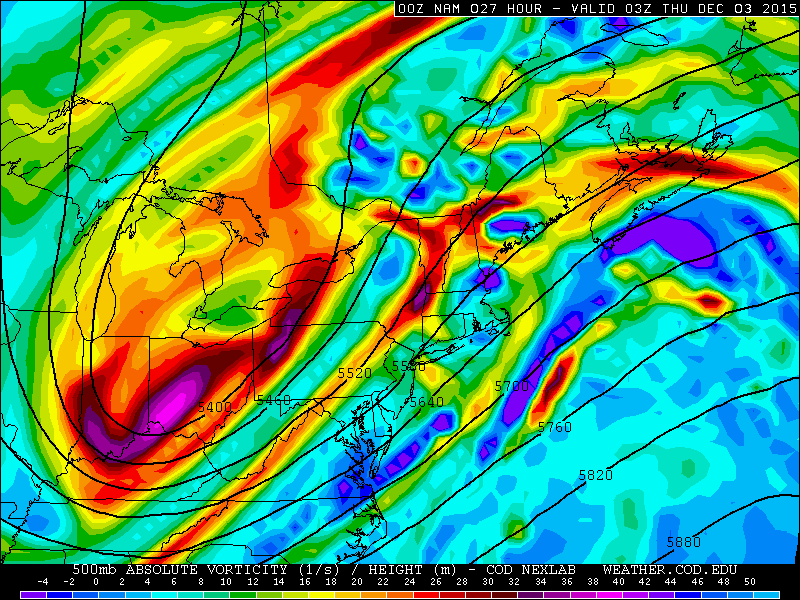
The low resolution NAM shows the convergence with the trough over Lake Erie and far NE OH/NW PA extending up above 700mb, with good vertical velocities showing up as a result. On its own, convergence this strong would likely be enough to get half decent precip to develop. In addition, positive vorticity advection in the mid-levels with the upper trough is also a source of lift.
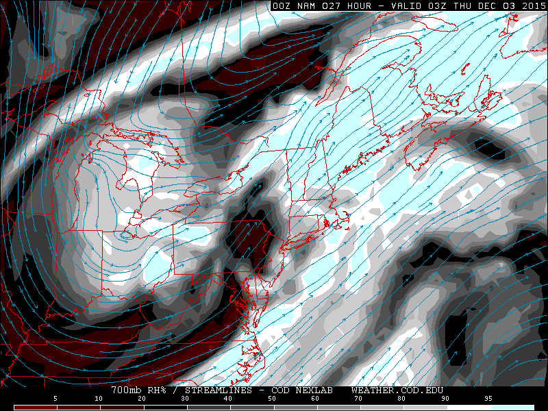
In addition to a good amount of lift from the trough moving over Lake Erie/far NE Ohio, the upper trough will provide for very deep ambient moisture…to around 500mb…so moisture will not be a limiting factor to this event.

Although lake to 850mb and lake to 700mb temperature differentials won’t be extreme…13-15C for the lake to 850mb differential and 23-25C for the lake to 700mb differential…the upper trough moving directly overhead will bring inversion heights way up, to near 15k feet. So although lake induced instability isn’t “extreme,” there’s lake induced CAPE and deep moisture to 12-15k feet or slightly higher from Wednesday evening through early Thursday. 500mb temperatures are progged to get to around -32C Wednesday night, which gives lake to 500mb temperature differentials of 40-42C off of the central and eastern basin. This is around the threshold for thunder, so although there won’t be a lot of lake induced CAPE, the deep layer of moisture/instability and strong lift from the trough through a fairly deep layer of the atmosphere may be enough for some lightning strikes over and near the lake at times, mainly during the first half of Wednesday night.
At this point I’m fairly convinced that moderate to heavy precip will develop Wednesday evening and persist for several hours Wednesday night…possibly over the Cleveland metro early on before shifting into the primary Snowbelt for a good chunk of time, before swinging southeast and then weakening early Thursday. The main questions now become if temperatures will cool quickly enough to support accumulating snow, and if this happens, where will the heaviest precipitation and possible accumulations be?

One factor that may be important will be wet bulb temps…especially south of the band…as WSW winds into the band could advect in this cooler/drier air and allow wet bulb cooling to occur under the band along with dynamic cooling from lift within the band and perhaps precipitation drag of cooler air down to the lower levels. The NAM at 10PM Wednesday has wet bulb temperatures near 40F under the band and above 35F across much of northern OH…while the GFS on the right is several degrees cooler. The difference appears to be due to the NAM showing dew points in the mid 30s persisting inland until much later Wednesday night, while the GFS cools dew points to near or below 30F inland from the band after midnight. Dew points to our west are in the upper 20s/lower 30s, so I am inclined to believe the lower dew points inland, which would support wet bulb temperatures being a bit cooler. The wet bulb temps appear to cool enough for a change to snow to start occurring after 10PM.
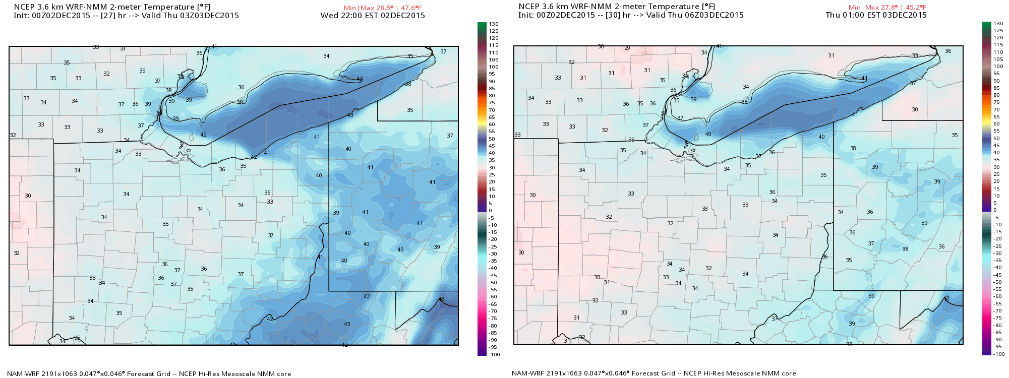
The NMM has temperatures under the band (this model has it across Lorain and Cuyahoga Counties initially) cooling to 33-36F by 10PM, with that cooling continuing as the band swings northeast over the next few hours into the primary Snowbelt after midnight. Given the potential for good dynamical cooling under the band and wet bulb cooling from cooler/drier air inland trying to get drawn into the band, a scenario like this seems quite possible…although the model does never get temperatures below freezing under the band.
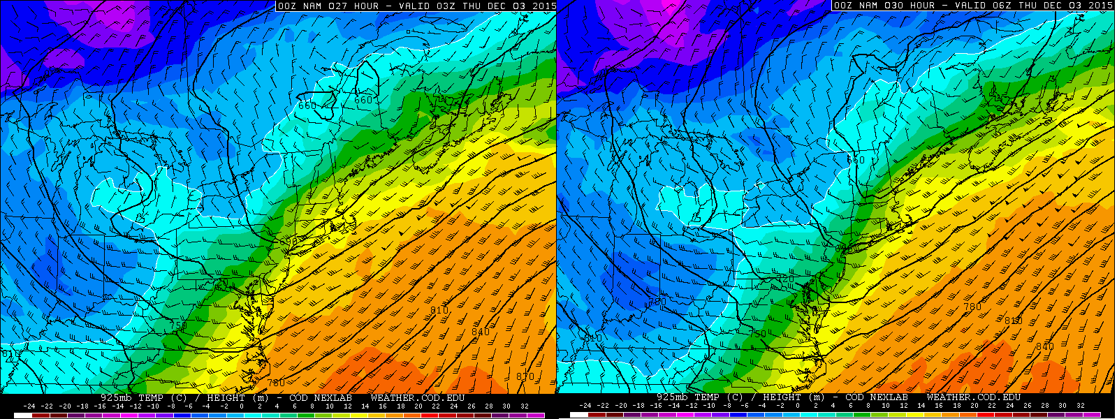
The NAM shows 925mb temperatures starting to fall below freezing by 10PM Wednesday…and getting below freezing in much of the NE OH Snowbelt by 1AM Thursday…by 4AM Thursday it also gets 925mb temps below freezing in NW PA.
Based on when wet bulb temperatures inland get below freezing and when 925mb temps are progged to fall below freezing, my guess is that locations inland from the lake, especially in the higher terrain in Geauga County and NW PA, will start changing to snow by 10PM Wednesday and become mostly snow by around midnight. The precipitation should start as rain possibly mixed with graupel initially, as low level temps will definitely be too warm for snow initially.
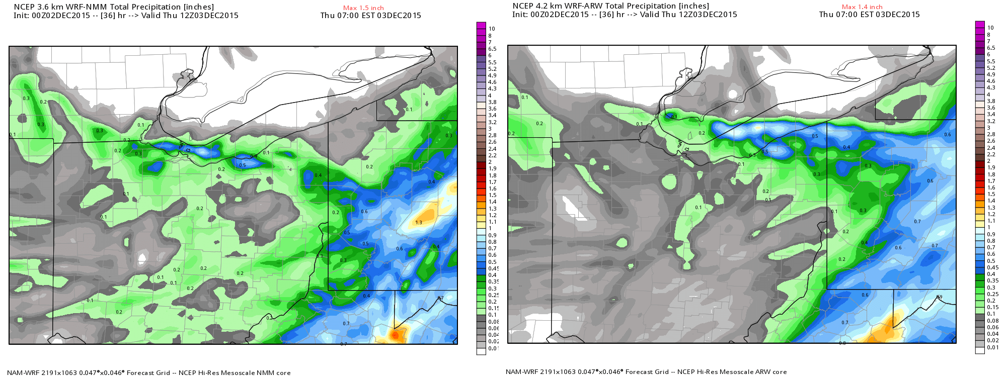
The hi-res models are in decent agreement on 0.50-0.75”+ of QPF where the band stalls for a few hours late tomorrow evening into the wee hours of Thursday morning. The Euro and low-res NAM also even have over half an inch of QPF, and the GFS has 0.25-0.50” of it.
At this point, for placement of the lake enhanced band, the NAM, Euro, GFS and ARW (along with most of BUF’s WRFs) develop it initially over the Cleveland metro before quickly moving it northeast into Lake, northern Geauga, Ashtabula and parts of Erie/Crawford Counties, while the NMM and hi-res Canadian are a bit farther south. The band placement will be mainly driven by where the synoptic inverted trough develops and less by lake effect processes, however with WSW winds south of the band and a warm lake possibly trying to focus the surface trough a little farther northeast, I’m going to lean towards the north camp. The models do swing the band SE early Thursday morning, which could bring a period of decent precip in much farther west, but it would be brief. Lake effect conditions remain OK into Thursday morning, but the synoptic support will be over, and winds will turn onshore which will push warmer air over the lake farther inland, so I doubt there are any real accums in the NNW flow lake effect Thursday morning once the trough moves southeast.
Accumulations with the trough are ultimately tough…we’ll definitely have a good amount of QPF to play with, and given there are mesoscale processes driving the precipitation including lake enhancement, I have to think the hi-res models with the higher QPF are more on the mark. The question, how much falls as snow and how well does it accumulate? I don’t expect any accumulations before 10PM…but should see the precip change to mainly snow (especially inland) between 10PM and midnight, with accumulations likely starting in the higher terrain by midnight. This gives a few hours and a quarter inch or so of QPF of potential accumulating snow in the primary Snowbelt before the trough swings southeast and takes the band with it. This could give 2-3” in the higher terrain in northern Geauga County and southern Erie/northern Crawford Counties. If the changeover occurs any quicker, or the models are a little too quick in shifting the trough southeast, someone could get a little more. I could see 1-2” in the rest of the primary Snowbelt excluding the lakeshore, with little to none along the lakeshore, as surface temps should stay in the 35-40 range. Maybe a heavier burst deposits a dusting along the shore, but I struggle to see any more playing out. There could be a brief burst of snow farther west later at night, but with marginal surface temps and a short duration of decent snows, although some grassy/car top type dusting are possible, I don’t expect more than an inch outside of the primary Snowbelt right now.
