
For some reason, I posted the forecast for this event as another page and not a post. Here’s the link to that page:
https://ohwxramblings.wordpress.com/december-18-19-2015-lake-effect-snow-event/
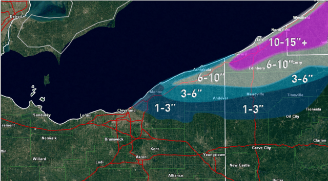
Based on storm reports and some estimation based off of radar/terrain, here is my best guess on how much snow fell during the event:

Here was my forecast:
The biggest bust may have been in Geauga County, due to banding getting farther south than expected Saturday morning. This resulting in 1-3″ and 3-6″ type snows getting farther south than expected. The heavy snow also got a bit farther south than expected across Ashtabula and Crawford Counties. Overall I’m happy with the forecast, as with the exception of central/southern Geauga County the differences from actual are fairly minor/cosmetic. Not perfect, but not terrible either, which is all I sometimes home for with lake effect snow.
There was some interpolation/estimation to fill in the map, as spotter reports are often spaced pretty far apart. Used radar/satellite loops and elevation maps to estimate as needed.
