

A pocket of arctic air beneath a deep upper level trough moving over the Great Lakes will set off lake effect snow Sunday through Monday downwind of Lake Erie. Upstream lake connections and synoptic moisture/lift will be key to where the heavier snow sets up and how much snow falls in this short fetch lake effect event.

A shortwave glancing Lake Erie to the north will push a surface trough south across the lake Sunday morning, with 850mb temperatures cooling to -10C by Sunday afternoon. With water temps in the central and eastern basin still around 42F/6C, this creates a lake to 850mb temp differential of 16C which is enough to get a lake response. Because the shortwave only glances to us as it moves by to the north on Sunday, the cold airmass is fairly shallow, with inversion heights and moisture depth only to 5-6k feet through the day Sunday, and only touching the lower portions of the snow growth zone. Convergence along the shoreline that models show to be slow moving during the day will help focus snow, but other parameters suggest any lake effect Sunday morning into the afternoon will be pretty light with poor snow ratios.
By late Sunday afternoon what’s left of the shortwave finally pushes across Lake Erie into northern Ohio, perhaps helping to bring inversions up some due to some weak large scale lift with the shortwave. This may result in somewhat of an uptick in lake effect Sunday afternoon.
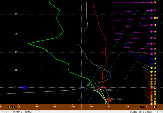
Forecast soundings from this timeframe suggest that lake effect parameters still won’t be great, with inversion heights and moisture only getting to around 5k feet. With steep lapse rates below the inversion it’s possible there are some briefly moderate snow showers, but well aligned NW winds suggest that convergence should push south of the lakeshore by mid to late Sunday afternoon. All in all, the ingredients won’t be there for much lake effect during the day Sunday. There will certainly be snow showers, initially from eastern Cuyahoga points east in the morning as the surface trough starts slowly pushing inland, and then in both the primary and secondary Snowbelts in the afternoon in the NW flow, but amounts will be light and ratios won’t be great. It’s possible the higher terrain in Geauga gets an inch or so through the day Sunday, but I think that would be the most anyone sees. Other areas could see minimal accums as the NW flow tends to spread the snow showers west and south of Cleveland too.
As we head through Sunday evening the winds slowly go more NNW and slightly colder air moves in, allowing inversion heights to come up a bit and allowing moisture depth to also increase a little bit. The winds for a few hours Sunday evening support moisture from central Lake Superior and northern Lake Michigan getting to Lake Erie which could help pre-seed things.

Forecast soundings by later Sunday evening have improved some from Sunday afternoon, with equilibrium levels getting pushed up to near 7k feet and the instability starting to build into the snow growth zone. This would allow for somewhat more intense snow showers and ratios probably climbing above 10:1 Sunday evening. Although the fetch is short, the winds below the inversion are fairly light and well-aligned, which may maximize how much moisture is picked up with the short fetch. A period of some pre-seeding from the Great Lakes in the evening could result in a burst of snow showers in the higher terrain of the primary and secondary Snowbelts that produces an inch or so of accumulation. Probably much less closer to the lakeshore. As the winds slowly veer more northerly Sunday night and Lake Superior/Michigan connection would likely shift west of Cleveland, and the attention would turn to an expected Lake Huron connection moving in from the east.
The wind direction appears to favor any Lake Huron band getting into Ashtabula County between about 8PM Sunday and 4AM Monday before shifting west. This is a good 8 hour window of potential heavy snow rates in the county, although it’s possible the band snakes around a bit in Ashtabula County and keeps amounts somewhat under control.
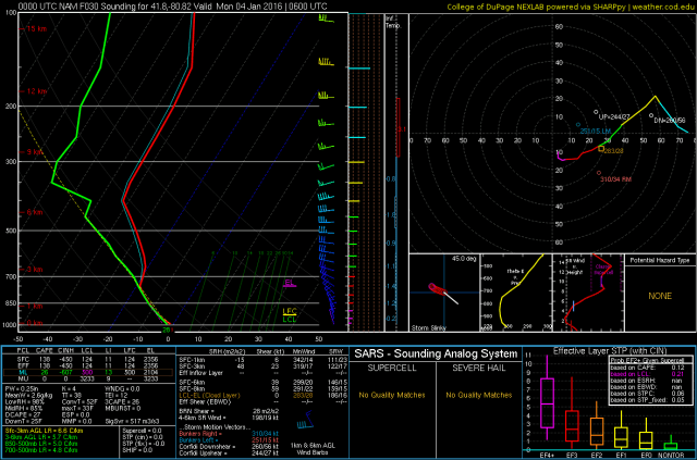
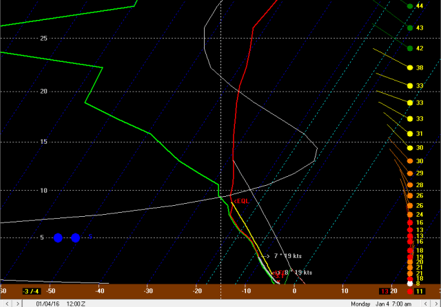
Forecast soundings from the NAM near Ashtabula/under the band from 1AM Monday reveal a tremendous thermodynamic environment for good lake effect…with steep lapse rates through the entire snow growth zone and up to near 700mb along with very moist low levels. Wind shear is a little iffy, but otherwise the environment easily supports 1-2” per hour snow rates under the band for several hours while it is in Ashtabula County.
Outside of the likely Huron connection into extreme NE Ohio Sunday night, the question is can snow keep going during the overnight hours after upstream lake moisture shifts to the west. It may be iffy for a little bit around midnight, however after midnight the core of the upper level trough begins moving overhead allowing moisture to increase, inversion heights to come well up, and also adding some large scale lift.
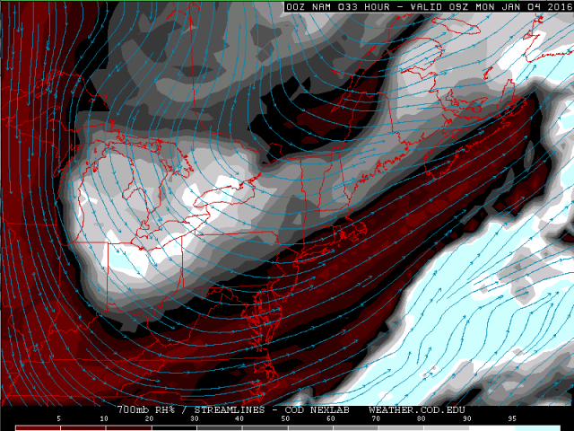
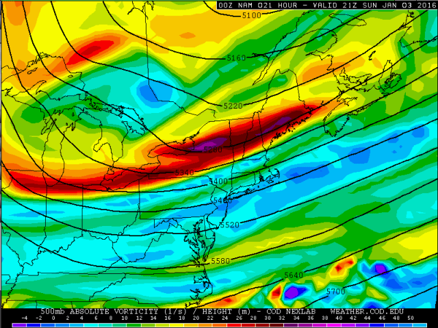
By 4AM Monday, the GFS, NAM and Euro (NAM pictured above) all agree on a lobe of deep moisture with the upper level trough moving over Lake Erie. They show mid-level RH values increasing by 1AM Monday and becoming very high for a few hours by 3AM. In addition to some moisture from the trough, a shot of vorticity advection will provide for some large scale ascent at the same time:

In addition, even outside of the Lake Huron band, forecast soundings show a much improved thermodynamic environment late Sunday night, with equilibrium levels rising to near 10k feet, moisture and instability through the entire snow growth zone, and reasonably well-aligned NNW winds:

With steep lapse rates through most of the snow growth zone, high equilibrium levels, along with moisture and lift from the upper level trough itself, I’d be utterly shocked if multi-banded lake effect didn’t start re-developing shortly after midnight Sunday night. With probably enough synoptic moisture and lift for some light snow without any lake influence, I’d have to think that by 3-4AM Monday that west of the Lake Huron band that the radar will fill in, with moderate snow in the higher terrain thanks to orographic lift from the terrain. With steep lapse rates and moisture through most of the snow growth zone, snow ratios should increase dramatically in this timeframe as well and could easily get into the 20:1 range at times.
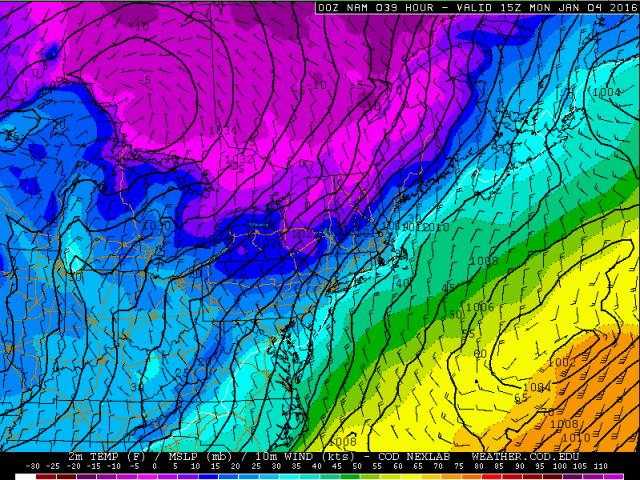
By 10AM Monday, the surface winds are going NE over Lake Huron and due north or east of due north over Lake Erie, which will likely push any Huron connection west pretty quickly between 4AM and 10AM Monday. With winds taking on a pretty strong easterly component over Lake Huron, the band will likely swing all the way through the Cleveland metro and into the far west side Monday morning. This band will likely be moving pretty quickly across the Cleveland metro as the wind shift is pretty dramatic, especially over Lake Huron, which will limit how much snow any one spot gets, however the band could be very impressive as it swings west.
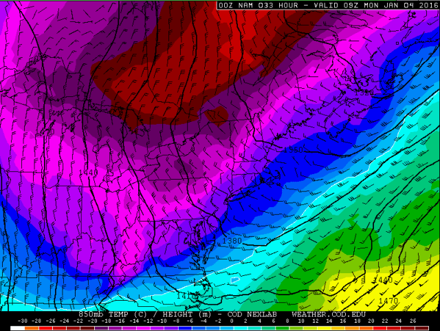
The band will swing across the Cleveland metro as lake effect conditions are maximized beneath the heart of the upper level trough. At 7AM Monday, lake to 850mb temp differentials of near 20C, lake to 700mb temp differentials of near 30C, and lake to 500mb temp differentials of near 40C will yield extreme instability, high equilibrium levels over 10k feet and maybe even the potential for thunder. In addition, moisture gets to near 10k feet and winds are fairly light, maximizing how much moisture can be picked up with the short fetch. Instability and very strong omega (the white line) through the dendrite growth zone suggest very high snow ratios and efficient snow rates. Although the Lake Huron band may not stay in any one spot for more than maybe an hour Monday morning as it swings west, it could certainly produce a very quick 1-2” of snow in many areas and have a disastrous impact on the Monday AM commute in Cleveland.

By noon Monday the upper level trough starts moving off to the east, resulting in moisture depth and inversion heights really coming down. By late Monday afternoon, there is still a well aligned NNE flow with very steep lapse rates through the snow growth zone, so I suspect that weaker multi-bands will persist through Monday afternoon, favoring the higher terrain. There sometimes seems to be some convergence near I-71 in this setup which could result in a slightly more focused band across parts of Cuyahoga/Medina/western Summit for a time. With the mid-levels really drying and inversions coming down, along with still a fairly short fetch, I don’t anticipate major additional accumulations Monday afternoon, but some higher terrain locales could see another inch or so. The Lake Huron band may result in light to occasionally moderate snow continuing in the north-central Ohio lakeshore into Monday evening as well.
So to sum up, I expect light LES to break out from Cuyahoga points east Sunday morning, with the LES expanding SW Sunday afternoon as the winds go NW. Amounts on Sunday will be light, up to an inch in Geauga but minimal elsewhere. Sunday evening I expect a temporary uptick in LES as some upstream lake moisture moves east to west across the Snowbelt and Cleveland metro. With a short fetch and still fairly marginal moisture/instability, this activity should favor the higher terrain and still be fairly light, with maybe an inch or so in some spots Sunday evening. I expect a Lake Huron band to begin taking shape in Ashtabula County Sunday evening and really become heavy overnight with only some minor fluctuations in band location from late Sunday evening through early Monday morning, possibly resulting in locally heavy amounts in Ashtabula County. West of the Huron connection, I expect a decrease in snow briefly around midnight, with snow ramping back up quickly after midnight. By 3-4AM I expect fairly numerous snow showers west of the Huron band with locally moderate snow in the higher terrain. This only lasts a few hours as the Huron band shifts west with a brief period of heavy snow and quick accums of an inch or two. The snows after midnight Sunday night and before the Huron band could produce 1-2” in the higher terrain in the secondary and primary Snowbelt, with minimal amounts closer to the lakeshore. Behind the Huron band there will be a couple hour window before the better synoptic moisture and lift pull out where light to moderate snows focused on the higher terrain could continue and maybe produce another inch by noon Monday, before moisture and inversions start lowering Monday afternoon limiting activity to fairly weak multi-bands, with a possible exception of a slightly better band over the secondary Snowbelt for a time. Additional accums Monday afternoon will most likely be less than an inch.
For amounts, could see over 6” in Ashtabula County where the Huron band is most persistent Sunday night. Could also see up to 6” in the higher terrain in Geauga and eastern Cuyahoga where they’ll be favored for much of the event where elevation will be key. Could also see up to 4” in the higher terrain of the secondary Snowbelt for the same reason. Elsewhere amounts will drop off quickly towards the lakeshore, with the majority of the snow along the shore and in the city of Cleveland occurring in a brief window Monday morning while the Huron band swings west. With the Huron band moving well west there will be some light accums pretty far west for a LES event.
