
In an effort to identify scenarios that support heavy, single banded lake effect snow into Cuyahoga County, I looked at several recent warning criteria lake effect snow events in Cuyahoga County that were caused by a single band of heavy snow (not multi-banded and/or orographic lift, or lake enhanced snow). The sample size is small but potentially useful. These events were off the top of my head as I’m quickly throwing this together, I’m sure I missed some events in the late 2000s.
The following are surface maps from warning criteria, single banded events in Cuyahoga County that effected a fairly large portion of the county with heavy snow events. Surface maps are from the approximate time of maximum snow intensity:
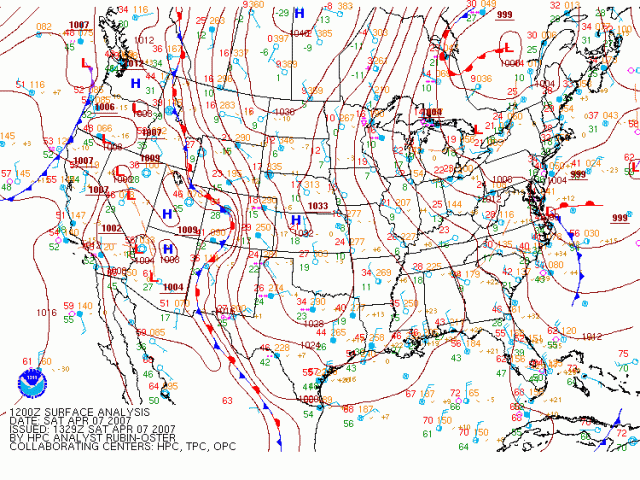
April 7th, 2007:
 Link to surface maps from this date for you to scroll through as you please:
This was a part of a long duration, significant and out of season event. A heavy band of snow developed from the northwest portions of Cuyahoga County and set up east or slightly south of east towards the southeast portion of the county towards Solon and Chagrin Falls. Amounts from the band were in the 6-10″ range.
The isobars over Lake Erie and Northeast Ohio are roughly oriented NW to SE, with a clear surface trough evident over central lower Michigan dropping south or southeast. There is a surface low over south-central Quebec and a surface high extending from western Manitoba south across the central Plains.
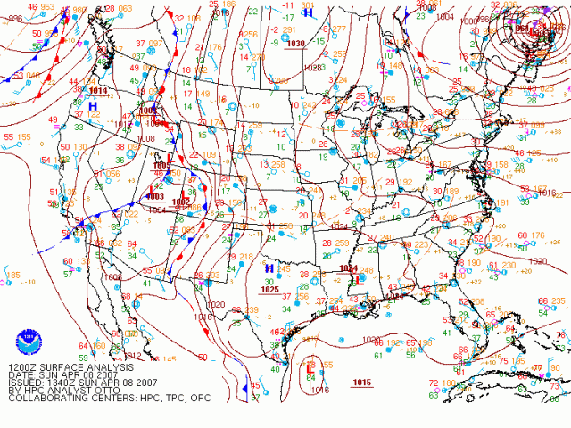
April 8th, 2007:
Link to maps from this date:
This was a part of the same event described above, just a day later. A band of heavy snow redeveloped on the evening of the 7th into the morning of the 8th, a few miles farther north than the previous night. The band set up from near downtown Cleveland east towards east-central Cuyahoga County, with heaviest amounts near or just south of the 322 corridor in eastern Cuyahoga County. Amounts with the band were up to a foot on the east side.
The isobars are oriented a little more WNW to ESE, with a stronger surface low near the northern tip of Nova Scotia and the surface high slightly farther east extending from central Manitoba south across the Plains. A clear surface trough is evident across central lower Michigan.
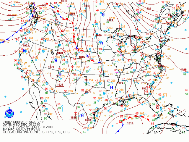
December 8th, 2010:
Link to maps from this date:
Anyone who lived in Cleveland into December of 2010 should remember this event. A band of heavy snow developed across northern and eastern Cuyahoga County during the morning on December 8th and intensified during the afternoon while remaining nearly stationary. The heaviest snow affect the western lakeshore and downtown Cleveland (with over 10” of snow near downtown) and extended east into much of eastern Cuyahoga County, with even Solon receiving warning criteria snowfall. The band shifted south and weakened during the evening of the 8th. This came at the end of a significant, multi-day lake effect event.
The isobars are roughly oriented northwest to southeast, with a clear trough near or just north of Lake Erie. There is a surface low located east of Hudson Bay and a surface high extended from near the Ontario/Manitoba border south across the Mississippi Valley. A nose of higher pressure extends east across the Ohio Valley as well.
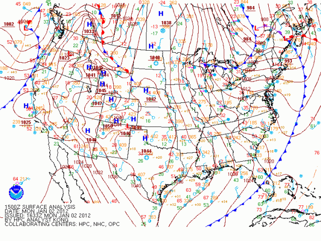
January 2nd, 2012:
Link to maps from this date:
This occurred at the beginning of a warning criteria (but not incredibly notable) lake effect event for the primary Northeast Ohio Snowbelt. A snow band developed across the eastern lakeshore in Lake and Ashtabula Counties overnight on the 1st into the 2nd and shifted into eastern Cuyahoga County on the morning of the 2nd and persisted for a few hours, before shifting south and dissipating. Warning criteria snow occurred during a 12 hour period during the daylight hours on the 2nd in portions of east-central Cuyahoga County. This is a marginal case.
The isobars are oriented roughly northwest to southeast, with a surface low located southeast of Hudson Bay. High pressure extended from central Manitoba south-southwest towards central Texas. A surface trough is evident over northern lower MI and central Lake Huron and is analyzed as a cold front on this map.
January 22nd, 2013:
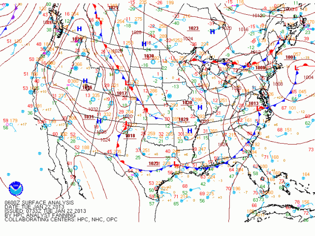
Link to maps from this date:
This was a part of a fairly decent multi-day event in the primary Snowbelt mainly east of Cleveland. A single band of snow developed across northern and eastern Cuyahoga County late in the evening on the 21st and persisted into the morning on the 22nd, before shifting south and weakening by late morning on the 22nd. The heaviest snow occurred from the lakeshore in Cleveland east towards the eastern suburbs such as Lyndhurst and Mayfield. Amounts from the band were over 6″.
The isobars are roughly oriented northwest to southeast, with a clear surface trough analyzed as a stationary front extending across northern Michigan and Lake Huron. A smaller surface trough is analyzed in southeast Michigan but has a minimal impression on the pressure field. A surface low is located off the New England coast, with high pressure extending from North Dakota south-southeast towards Illinois and Arkansas. A nose of higher pressure extends east through the Ohio Valley.
October 24th, 2013:

Maps from the date:
This was one of the most significant October lake effect snow events that Northeast Ohio has seen in recent memory. A snow band developed in the evening of the 23rd, initially across northern and eastern Cuyahoga County east into Geauga County, before shifting north into Lake, northern Geauga, and Ashtabula Counties for a few hours. The band settled back south into northeastern Cuyahoga County early in the morning on the 24th and was persistent through most of the afternoon from over or just north of downtown Cleveland east towards Mayfield, at times getting as far south as Beachwood, but generally a little farther north. Snowfall amounts of near 8” occurred in Mayfield Heights. If this occurred when it was colder, snowfall totals of 1 to 2 feet very well could’ve occurred on a fairly widespread basis. The band shifted south and weakened during the evening on the 24th.
The isobars were generally oriented WNW to ESE…however, a very well-defined trough moving across the lake had a strong impression on the pressure field downwind of the trough in Northeast Ohio. A low was located east of Hudson Bay with a high extending from southeast Alberta towards Kansas. A small area of higher pressure extended east through the Ohio Valley.
November 14th, 2014:

Maps from the date:
This was a part of a multi-day event focused from northern Lorain County points east. A strong band of heavy snow developed along the eastern shoreline from Lake County up through Erie County PA on the 13th, with some areas receiving over a foot of snow during the day on the 13th. That first single band swung southwest during the evening and produced a quick couple inches or more of snow as it went as far west as parts of central Lorain County, before the band broke up and multi-bands took over for a time. A single band re-organized early in the morning on the 14th from northern Lorain County east across a large portion of Cuyahoga County and southern Geauga County and persisted for several hours, before becoming more diffuse in the evening on the 14th. The second band allowed portions of eastern Cuyahoga County to reach the 24 hour warning criteria of 8” or more of snow.
The isobars were oriented northwest to southeast, with a modest surface trough evident from central Lake Huron points west. A surface low was located well off the New England coast, with a surface high across the eastern Plains. Higher pressures extended east through a good portion of the Ohio Valley.
November 20-21st, 2014:

Maps from the data:
This event came at the end of a multi-day event that dropped feet of snow on western New York south of Buffalo. A well-established single band pushed southwest across the lake late in the afternoon and into the evening on the 20th and swung through Cuyahoga County fairly quickly, before stabilizing for several hours from northwestern Lorain County east-southeast into southwestern Cuyahoga County, just south of the airport. Snow totals of up to 6” occurred in parts of southwestern Cuyahoga County. The band quickly broke up on the morning of the 21st as high pressure moved in lowering inversion heights and as winds turned more northwesterly.
The isobars when the band stabilized across parts of Cuyahoga County were oriented NW to SE, with a clear trough near the south shore of Lake Erie and another one farther northwest across central lower Michigan and Lake Huron. A surface low was located north of Maine and a surface high stretched from Iowa to Kentucky.
November 27th, 2014:
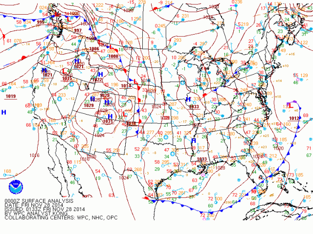
Maps from this date:
This was a short duration, high intensity event. The event started early in the morning on the 27th as a surface low moved up the East Coast and swung the winds around from NE to NW. Multi-banded lake effect with some Lake Huron connection developed into the west side early in the morning and quickly swung east across the Cleveland metro into the primary Snowbelt and dissipated by late morning. 1-2” of snowfall fell in parts of the metro with this portion of the event. The snow essentially ended for several hours before a surface trough dropped across the lake during the evening and produced a single band of heavy snow into northern Lorain, southern and eastern Cuyahoga, far northern Summit, southern Geauga and northern Portage Counties for a few hours, before the trough shifted south causing the band to shift south and break up. Snowfall rates of 3” per hour were observed at CLE and some areas received 6” of snowfall in under 3 hours, making this a warning criteria snowfall.
A surface low during the time of the band was located northeast of Nova Scotia, with a surface high extending from Iowa to Mississippi. A surface trough was located over Lake Erie when the band occurred. Isobars were located north to south north of the trough and NW to SE south of the trough.
Summary:
Every event featured isobars oriented a pretty true NW to SE. A couple of events had isobars slightly more westerly than northerly, but were generally oriented NW to SE or very close to it. Every event featured lower pressure somewhere to the east or northeast, with an inverted trough extending back towards the Great Lakes. Most of the events that locked a band in for more than a few hours also had high pressure extending east from the central US into the Ohio Valley…events like 11/27/14 and 1/2/12 that were more marginal and didn’t feature a well-organized band for more than a few hours didn’t have higher pressure nosing into the Ohio Valley as well as the other events did. Every event had at least a subtle surface trough over Lake Erie or not far to the north.
It seems that for a single band of lake effect snow to produce warning criteria snow into a good portion of Cuyahoga County, a few things are needed (other than the obvious proper moisture/instability for a strong lake response):
-Low pressure to the east or northeast with an inverted trough extending towards the Great Lakes. The inverted trough doesn’t seem to be required as a couple of good events didn’t have it, but most events do have a feature like that.
-At least a subtle surface trough over the lake or just to the north of the lake. An inverted trough extending west from a surface low to our east or northeast can serve this purpose.
-Isobars oriented northwest to southeast. More WNW to ESE isobars may still clip the extreme NE corner of the county but would likely miss a majority of the county.
-High pressure nosing into the Ohio Valley appears to make it more likely for bands to lock into place for more than a brief period of time.
-High pressure placement to our west doesn’t seem extremely important, as long as the high is centered to the west somewhere with preferably some higher pressure extending east into the Ohio Valley.
Shortfalls:
Obviously this is a small sample size off the top of my head. There is the possibility that other seemingly favorable environments with similar pressure patterns didn’t produce, so this doesn’t scratch the false alarm rate of using isobaric patterns to predict if a single band of lake effect snow will occur in Cuyahoga County or not. Only warning criteria events were used…shorter duration events that only produced advisory snowfall were not explored as again, this sample was off the top of my head. More obviously goes into lake effect forecasting than the isobaric pattern, however, all 9 events featured very similar patterns so I believe this information can still be useful.
