

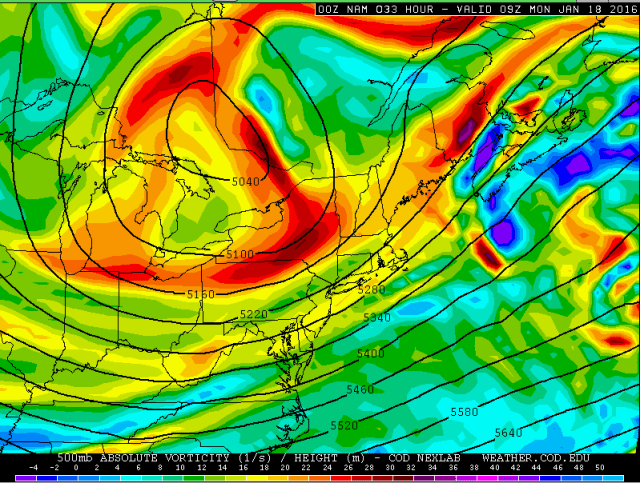
What could be the largest lake effect snow event of the season in Northeastern Ohio is imminent as a lobe of the polar vortex brings the coldest air of winter thus far over the almost completely unfrozen waters of Lake Erie over the next couple of days.

A cold front will move through NE Ohio and NW PA early to mid-afternoon on Sunday, with arctic air behind the front. This front will be passing through as a modest shot of positive vorticity advection (PVA) along with lift on the nose of a low to mid-level jet and in the left-exit quadrant of an upper level jet are all intersecting over the area as the front moves through. With forecast soundings showing nearly saturated profiles up to about 15K feet as the front goes through, I certainly think this large scale lift will set off a general area of light snow late Sunday morning into the early afternoon across NE OH and NW PA. As the front moves through, forecast soundings show steep lapse rates and a little bit of CAPE into the snow growth zone (DGZ) which when combined with strong convergence/low level lift with the front itself will likely result in some snow squalls developing along the front:

A forecast sounding for CLE off of the 0z 4km NAM as the front approaches shows the deep moisture (and weak lift in the mid-levels associated with the large scale lift discussed above, the white line is vertical motion, to the left is rising/upward motion), along with some CAPE to about 6k feet and through a good portion of the DGZ. This supports the notion of a general light snow for a couple or few hours with squalls along the front where low level lift will be maximized. In addition, there will already be some lake induced CAPE, so the squalls over the Snowbelt may pack a bit more of a punch along the front as the lake will add some additional instability.
All in all, think the period of light snow and brief embedded squalls along the front will produce a general inch or so of snow for most of NE Ohio, with perhaps 2-3” in the primary Snowbelt in NE Ohio and NW PA where more instability will likely strengthen any snow squalls along the front. Ratios may be mediocre outside of any squalls which will likely limit over-performing potential with the synoptic snow.
After the light amounts of synoptic snow, the attention will inevitably turn to lake effect snow as a very deep and cold upper low moves across the Great Lakes.

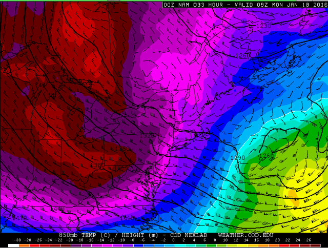
There will likely be a period late Sunday afternoon and into the evening behind the frontal passage where lake effect takes some time to organize…which is fairly common…note how by 1AM Monday, the NAM is still just starting to develop better convergence across the Snowbelt. However, the above temperature/pressure pattern appears favorable for a strong, single band to eventually form from Cuyahoga County points east with NW to SE oriented isobars, a surface low pulling away to the east, some hints at a lake aggregate trough developing in the isobars, and another little trough evident in the isobars over southern Lower MI.

Even if any bands struggle to consolidate some for a time Sunday evening, forecast soundings still suggest some decent moderate bursts of snow in the primary Snowbelt with W or WNW winds, moisture to 5k feet or so and equilibrium levels of near 11k feet. Forecast soundings from Erie are even gaudier with the instability Sunday evening with EQ levels near 13k feet and slightly warmer lake waters. I’d have to suspect that moderate to heavy orographic lift snows will occur in the higher terrain in inland Erie County and northern Crawford County Sunday evening even without a well-organized band due to the long fetch, extreme instability, pre-seeding and a fairly well-aligned flow.

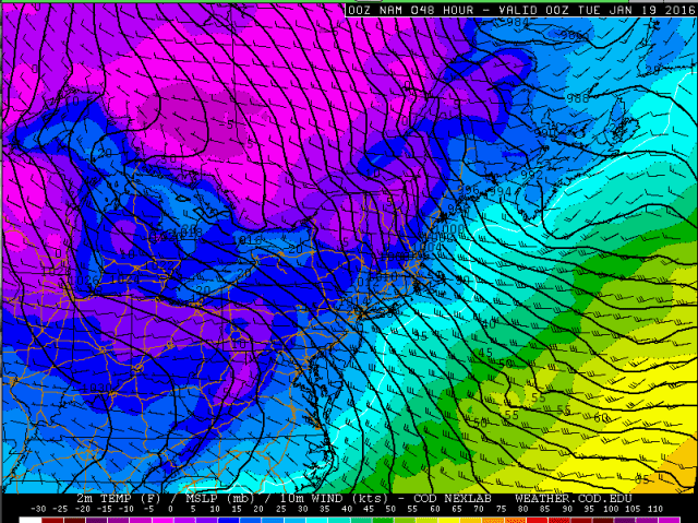
The NAM and Euro both agree on convergence really increasing across the Snowbelt after 1AM Sunday night into Monday morning as a trough drops southeast across Lake Erie while pressure rise over land and temps cool into the single digits inland.
The trough dropping across the lake appears to be a result of another lobe rotating around the PV and moving across Lake Erie and northern OH/NW PA late Sunday night into Monday morning. This should provide some modest upward motion to enhance the lake effect further. In addition, this little lobe brings the coldest temps aloft, with 500mb temps bottoming out over the lake at near -40C early Monday morning. With lake to 850mb temp differentials of 22-24C…lake to 700mb differentials of 31-33C…and lake to 500mb differentials of 40-44C late Sunday night into Monday morning…along with some weak synoptic lift, a connection from Lake Michigan, and strong convergence over the Snowbelt, I have to expect a very focused and strong band to occur after midnight Sunday night into Monday morning as the trough approaches and pushes across the lake. Snow rates could briefly max out at 3” per hour under the band as the trough pushes into the lakeshore communities early Monday morning and maximizes convergence.

A forecast sounding for CLE off of the 0z 4km NAM valid Monday morning as the trough is pushing through shows a deep layer of instability with high equilibrium levels and well-aligned winds. The DGZ is confined to the lowest 3-4k feet due to the very cold air, but the model shows the lowest 2-3k feet of the cloud layer being in the DGZ with the strongest upward motion also in the DGZ. So although the cold may keep ratios of getting to very high values such as 30-40:1, I think 20:1 is still very much doable Sunday night into Monday morning which will allow for relatively efficient accumulations. Forecast soundings for Erie are even more impressive, with equilibrium levels near 15k feet and around 1000 J/KG of lake induced CAPE…supportive of very heavy snow rates.
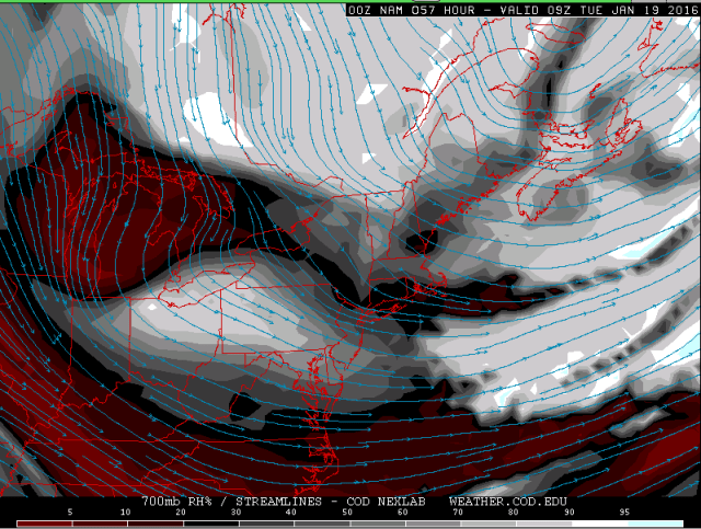
As for band placement Sunday night into Monday morning…the NAM surface winds suggest it’ll be focused from extreme NE Cuyahoga east across southern Lake, northern Geauga, southern Ashtabula and into southern Erie/northern Crawford Counties. However, the isobar orientation as seen a few images up is a very close match to previous Cuyahoga County single band cases, and 850mb winds seen in the above image are in the 290-300 range over NE Ohio and the lake, which suggests winds over the lake should try to take on a pretty good northwesterly component and push the band inland a little bit. Everything suggests the band should sit 5-10 miles farther south than the band last Tuesday night sat. The 0z ARW has the band from near Avon east across most of northern and central Cuyahoga County east into Geauga County, with the heaviest just south of 322. The NMM is a bit farther north and takes the best band from Cleveland and Bratenahl ESE and is more centered right on 322. The winds backing some over land do give me pause on bringing the band too far south so I tend to think that the NMM is closer on band placement Sunday night into Monday morning as the trough approaches. Think there could be a 4-6 hour window from about 2AM-7AM (give or take an hour) where the band moves very little as the trough approaches, with the band swinging south into more of Cuyahoga and southern Geauga Counties *briefly* immediately behind the trough, before starting to slowly drift back north. There could be significant accumulations in that window where the band sits. In NW PA with a due west or WNW wind ahead of the trough, think the banding will stretch from northern Ashtabula east across inland Erie and northern Crawford for several hours, with snow rates of 1 to perhaps 2” per hour at times over the higher terrain given the very strong instability and lift with the trough. Could also see rates locally max out higher here too as the trough pushes inland and really enhances convergence for a time.
During the day Monday expect the band to start lifting back northeast up the shoreline as high pressure noses in ahead of the next trough and backs winds a good bit. The band could very well disorganize for a few hours Monday morning behind the trough which is again, typical, but with continued extreme instability and a long fetch, I’d still expect moderate to heavy snow showers in the primary Snowbelt, perhaps favoring the higher terrain some…they just won’t be as organized. By Monday evening the models are really increasing convergence across Ashtabula and Erie Counties as temps start dropping again inland and high pressure continues to nose into the Ohio Valley, with another trough evident to the north starting to drop down. This suggests the band should start becoming more focused again by later Monday into Monday evening.

Forecast soundings from Erie for Monday evening off both the 12km NAM and 4km NAM show continued high EL’s, good moisture, fairly well aligned winds and very strong lift in the DGZ. As convergence increases Monday evening and the band re-orgnizes I’d expect heavy snow rates of 1-2” per hour to resume. During the day Monday it takes until about mid-afternoon for the winds over the lake to go due west, so the snow showers may affect northeast Cuyahoga, central and northern Geauga, southern Ashtabula, and at least northern Crawford County into the early to mid-afternoon before activity becomes focused farther northeast. With due west winds over the lake by Monday evening with WSW or even SW winds over land, I’d have to suspect the band will end up fairly far northeast, into perhaps northern Ashtabula and certainly into Erie County.

The potential for a well-organized, stable band Monday evening appears to be decent as one last good shortwave rotates in from the north late Monday night into Tuesday morning. This should bring another surface trough south across the lake late Monday night, increase mid-level moisture some and also provide some modest synoptic lift into play.
Most models I looked at (NAM shown above) do show a nice lobe of mid-level moisture dropping south-southeast across the lake late Monday night into early Tuesday with the shortwave. This all suggests pretty good snow rates beneath any band Monday night into Tuesday morning.

Forecast soundings from Erie overnight Monday night, while not as impressive as earlier in the event, are still good, with lake to 850mb and lake to 700mb temp differentials remaining near or better than 20C and 30C respectively suggesting extreme lake induced CAPE, along with equilibrium levels remaining near 10k feet…along with good moisture to about 8k feet and some moisture to about 13k feet, well aligned winds in the low levels and good upward motion in the DGZ. Snow rates of 1 to at times 2” per hour should be attainable with that kind of profile in any well-organized band Monday night.

As the trough drops south early Tuesday and starts turning the winds more NWrly over the lake while winds remain WSW or SW on land, convergence will become very strong over the Snowbelt from northern Lorain and Cuyahoga Counties points east Tuesday morning. This supports snow rates again maxing out at potentially 2-3” per hour briefly as the trough starts pushing south early Tuesday.

NAM forecast profiles for CLE still look decent Tuesday morning…easily supportive of heavy snow rates given the expected strong convergence as the trough approaches and then pushes south.
The trough could bring winds around to the NW enough to push the snow farther inland Tuesday morning than Monday morning…possibly getting into most of Lorain and parts of Medina/Summit/Portage for a time…before the high starts building back in and backing the winds again. Behind the trough inversions really crash on Tuesday and remain at 4-5k feet through the day. The activity should start shifting back northeast on Tuesday into the primary Snowbelt but will mainly be light by that point with just minimal additional accumulations.


BUFKIT time-height profiles for CLE and ERI from the low-res NAM indicate high humidity (color fill) and good lift (red contours) in the DGZ (purple/white contours in the lower portions of the images) throughout the event…with clear bullseyes when convergence and hence banding could very well be maximized at each location. This suggests moderate to heavy snowfall in the bands through the event with many areas seeing multiple possible windows of banding. Snow ratios will probably be good due to good lift and humidity in the DGZ but not great due to the cold suppressing the height of the DGZ.
As for specific amounts…expect 2-3” in the primary Snowbelt with the frontal snow through Sunday afternoon and an inch…locally a bit more elsewhere. Expect light accums Sunday evening before the band really organizes from eastern Cuyahoga County points east, especially in the higher terrain inland. Expect banding to flare up for several hours late Sunday night into Monday morning with little movement and heavy rates…think an additional 4-8” is quite possible where this banding sets up, possible near 322. NW PA will also see good snow in the orographic lift areas in this timeframe and will probably see a better band or two as well wherever upstream moisture from Lake Michigan makes it and possibly downwind of upstream bays over northern/western Lake Erie, which are often initiation points for bands. Think 5-9” in inland NW PA in this timeframe as it should snow just about all night with moderate to heavy snow for several hours after midnight. The banding should sag south briefly Monday morning and possibly drop an inch or two as far south/west as I-80. Expect the band to break up some Monday morning behind the trough and slowly push north through the day. Think maybe another 1-3” in NE Cuyahoga, Lake, northern/central Geauga, Ashtabula, Erie and northern Crawford in this timeframe, least near the lakeshore and most in the higher terrain.
Expect a better band to develop Monday evening near the lakeshore in Ashtabula into Erie County PA. The lakeshore in Erie County could get hit decently in this timeframe as well as winds on land really try to back. This band looks to have a several hour window of little movement and moderate to heavy snow and should produce another 4-8” where it sits Monday night, before pushing south early Tuesday. The band should persist for a couple hours or so as it pushes back southwest across northern/eastern Cuyahoga, southern Lake and Geauga and could produce a quick 2-4” or so as it goes…with lighter amounts possible again about as far south as I-80 Tuesday morning. Think another 1-2” in the primary Snowbelt (mainly in the higher terrain) from mid-Tuesday morning through Tuesday afternoon as the event winds down.
Totaling things up, get two areas where banding looks to be persistent for longest…parts of eastern Cuyahoga into northern/central Geauga…and also inland Erie County PA. Totaling things up in these areas am getting about 18-24” in parts of inland Erie County…with 12-18” in surrounding portions of Erie County, northern Crawford County and perhaps adjacent far eastern Ashtabula where there are some hills. Am also getting 10-20” in northern/possibly central Geauga County and far eastern Cuyahoga County along 322 and east of 271. Will call that 12”+ because I’m not sure they’ll get near the top end of the 10-20” range unless the band really sits in one area. There will be a couple of windows for banding along the western lakeshore west of Downtown although the banding looks more persistent farther east, so will bring moderate amounts into the western lakeshore, and put a little additional snow in for lake effect as far south/west as northern Lorain/northern Medina/northern Summit/northern Portage. The lakeshore in Lake County looks to see mainly transient banding and may struggle to see 6” or so over the course of the event. Will go a bit higher in NE Ashtabula as they could be under banding Monday night. Parts of Ashtabula may be in a bit of a whole between banding throughout the event as they often are but there will be plenty of window for snow…so I think inland Ashtabula can squeak out 8” or so over the course of 48 hours but the heaviest probably will be elsewhere.
