
A long duration moderate to heavy lake effect snow event looks to bring decent snow totals to the primary and secondary Northeast Ohio Snowbelts Tuesday night through Thursday night…
A low pressure will move drift from near London, ON to Upstate NY Tuesday into Wednesday, bringing winds around to the WNW and eventually NW across Lake Erie, while also allowing much colder air to flow in. An upper trough across the Great Lakes and New England will contain a couple of shortwaves and vort maxes rotating around that will help enhance any lake effect off of Lake Erie and keep the atmosphere moist. Upstream lake moisture will be present for a good chunk of the event. The NAM, GFS and Euro are all in surprisingly good agreement on the big picture and a lot of the specifics and have been for a few runs which adds some confidence to the forecast. Most images here are from the NAM as it tends to depict the Great Lake modification best.

Snow will likely increase Tuesday night as some modest synoptic lift drops across the lake behind the departing surface low. Some positive vorticity advection (PVA) associated with a vort max dropping across the lake will add some modest large scale ascent, and some weak low level convergence/frontogenesis between arctic air wrapping in from the southwest and a bubble of milder air closer to the surface low will also be present:

With deep moisture to nearly 25k feet Tuesday night, this weak large scale lift should support light synoptic snow dropping into northern OH Tuesday night. The lift isn’t strong so general accumulations will probably only be on the order of an inch or so outside of the Snowbelt.

Over the Snowbelt, a trough is expected to extend west from the departing surface low Tuesday night into Wednesday morning, with warming from the lake combining with this trough to generate convergence and lift over the primary Snowbelt Tuesday night into Wednesday morning. Lake induced instability and equilibrium heights are rather marginal Tuesday night, but should be enough to combine with the convergence to yield moderate snow in the primary Snowbelt Tuesday night into early Wednesday:

The winds over land won’t strongly back to the SW and at this point the air over land isn’t extremely cold, so the convergence and associated band of better snow should be able to push inland some from the lakeshore Tuesday night into Wednesday morning. With NW to SE oriented isobars which argues for the banding getting into Cuyahoga County and a WNW flow at 850mb, suspect that the band of better snow will affect northeastern Cuyahoga, southern Lake, northern and central Geauga, inland Ashtabula and inland Erie Counties Tuesday night. As for snow rates/amounts…deep moisture and modest synoptic lift combined with low level convergence and some lake induced instability could certainly yield steady light to moderate snow. Although a W flow isn’t ideal for upslope, with very moist low levels and steep lapse rates in the lowest few thousand feet the higher terrain may add enough lift for minor upslope enhancement as well. Snow ratios will be OK Tuesday night but not great…the DGZ will be saturated and fairly deep, but the best omega undershoots or barely gets into the DGZ. I suspect ratios will be on the order of 15-18:1 owing to the deep and saturated DGZ but only some of the better lift getting into it. Given the prolonged nature of steady light to at times moderate snow and OK snow ratios Tuesday night, suspect 3-4” amounts will be common in the areas outlined above. Some locally higher amounts of up to 5” may be possible in southern Lake/northern Geauga as they always do well in this type of flow and possibly in the higher terrain in Erie County where the large scale lift may be more favorable.
During the day Wednesday the surface low is expected to continue pulling east, pushing the surface trough a little farther south. This should spread the lake effect band farther southwest. Winds remain fairly WNW on Wednesday and there’s evidence of some convergence persisting in the Snowbelt, possibly due to colder air and somewhat higher pressures trying to nose east through the Ohio Valley. The modest synoptic lift and associated light snow should shift east/southeast Wednesday morning and lake to 850mb temp differentials will increase to 15-17C, which will allow the snow to take on more pure lake effect characteristics Wednesday morning. Lake effect conditions are OK Wednesday morning, but deep moisture remaining to 10-15k feet and convergence along the trough trying to push inland I suspect moderate snow will continue with the band along the trough. Snow ratios may increase a little Wednesday morning as the atmosphere cools a bit more and the DGZ lowers into the better lift.
By Wednesday afternoon lake induced instability and equilibrium levels start increasing to more respectable levels as colder air streams in. Deep moisture remains present to above 10k feet thanks to the upper trough overhead and lapse rates are almost absolutely unstable in the lowest 5k feet. There is a little bit more wind shear above 850mb here which along with the winds trying to push the trough inland may cause the LES to become more disorganized for a time Wednesday afternoon.

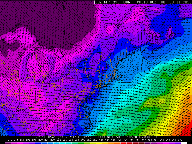
Even with that said…the increasing instability and still plenty deep moisture, along with very steep low level lapse rates suggest that decent snow showers will still continue. Ratios should climb above 20:1 in this timeframe per the above sounding with more of the upward motion in the DGZ and with good instability through the whole DGZ. Low level streamlines above suggest that a Superior-Michigan-Erie connection will be in play with a broad WNW or NW flow across the region into the Cleveland metro and primary Snowbelt, which along with decent instability and very good moisture should allow fairly good snow to continue in the primary Snowbelt. The snow may be less organized which could keep rates from getting out of control, but it should keep snowing. Very steep low level lapse rates and good moisture along with a more favorable flow for upslope will also help the higher terrain in this timeframe. The surface trough may shift far enough south that moisture from southern Lake Michigan combined with the layer of steep lapse rates and loose convergence along the trough could allow for disorganized but briefly moderate to heavy snow showers to occur very far inland, possibly as far inland as parts of Ashland, Medina, Summit, northern Stark and Mahoning Counties.
Overall during the day Wednesday I’m thinking an additional 3-6” in the higher terrain of the primary Snowbelt owing to the snow becoming less organized at times but still being moderate to heavy under any snow showers with good ratios. I could see 2-4” amounts in parts of Medina, Summit and Portage Counties, especially in the higher terrain due to the surface trough settling south towards these areas as the winds gain more of a northerly component and due to good flow for upslope and also moisture from southern Lake Michigan.

A fairly potent and negatively tilted shortwave is shown by all models to move across Ohio Wednesday evening. This shortwave will initially bring some large scale ascent ahead of it along with an increase in moisture, which will probably cause any snow showers outside of the lake effect to flare up and cause the lake effect to increase in intensity late Wednesday afternoon into Wednesday evening as the shortwave approaches and passes. The shortwave will also cause a response in the surface wind fields and cause winds to back a little more westerly late Wednesday afternoon/early evening before going more northwesterly behind it later Wednesday evening. This may cause convergence to increase near the lakeshore late Wednesday afternoon and early evening and cause a potentially transient single band to redevelop, before the band swings southwest Wednesday evening and multi-bands take back over.
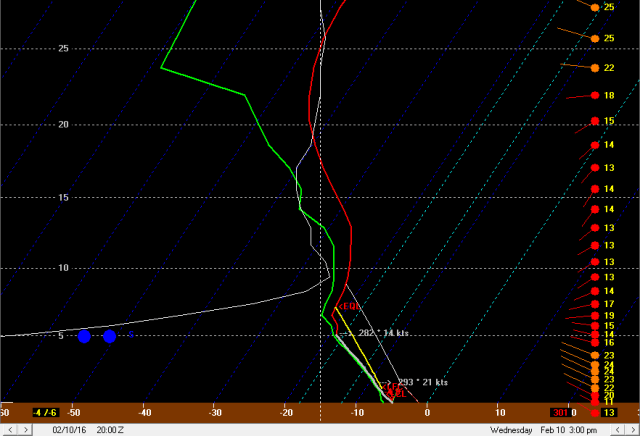
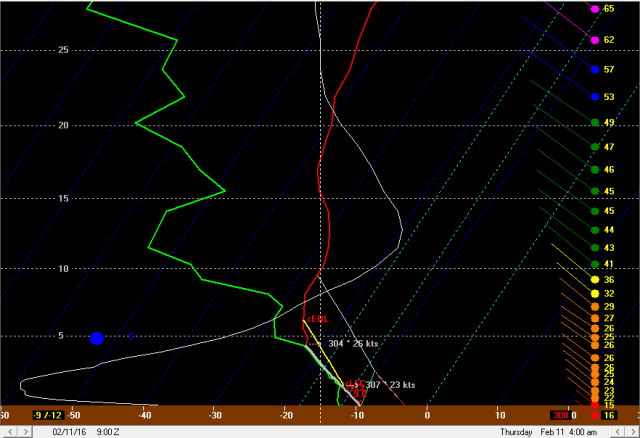
Forecast soundings from Wednesday evening as the shortwave moves by are fairly impressive, with very steep lapse rates extending to near 5k feet and lake induced equilibrium levels rising to near 10k feet. Moisture is very deep and shear is a bit less than earlier Wednesday afternoon. Very steep lapse rates and strong upward motion centered in the DGZ suggest very efficient snow ratios, possibly climbing to 25 or 30:1.
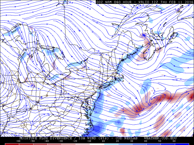
The NAM shows an increase in convergence just south of the lakeshore thanks to the wind shift associated with the shortwave, which if it verified would likely allow a more dominant single band to redevelop for a few hours Wednesday evening. With a more WNW flow in this timeframe the single band could certainly affect the Cleveland metro and western lakeshore for a time before swinging south and weakening. Outside of the potential transient single band, farther south there are still signs of remnant convergence from the first trough that pushes south earlier on Wednesday, with differences between lake modified air to the north and colder air farther south likely contributing to some loose convergence well south of Lake Erie Wednesday evening. There’s a clear fetch off of southern Lake Michigan into areas from Ashland to Akron/Canton to Youngstown if not a hair farther south with this flow, so with the added moisture/lift form the shortwave, good ambient moisture/instability, some Lake Michigan moisture and loose convergence, this strikes me as a situation where less organized but still very intense snow squalls occur Wednesday evening well outside of the Snowbelt, with local quick accumulations of a couple of inches.
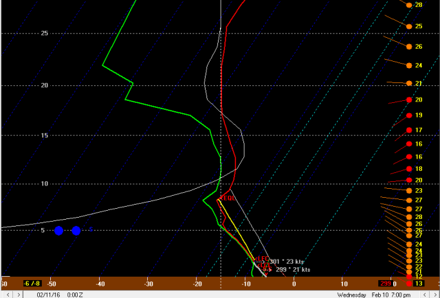
As mentioned, behind the shortwave late Wednesday evening through Wednesday night the winds go more northwesterly, but become very well aligned. Instability becomes moderate to extreme with lake to 850mb temp differentials pushing 20-22C and lake to 700mb temp differentials of 28-30C, with lake induced equilibrium levels of 9-10k feet. Moisture does start stripping away aloft later Wednesday night as the upper trough finally starts pulling away, which may make upstream connections much more important as this turns into a short fetch event with less than stellar ambient moisture. This regime supports potentially moderate to heavy snow showers with still high to very high ratios in any upstream lake connections but probably just flurries or light upslope snow showers outside of these connections.
Streamlines on the NAM suggest that some semblance of a connection to lower Lake Michigan may shift into parts of central Ohio and possibly affect the central highlands near Mansfield with snow showers by late Wednesday night and Thursday morning, with a potential Superior-Michigan-Erie connection into the Cleveland metro, secondary Snowbelt and western primary Snowbelt. This is quite a typical location for this connection with an almost due NW flow. The Lake Huron connection should try to effect NW PA with a NW flow as well. With plenty of instability and very well aligned winds supporting good inland propagation of bands and also moderate to locally heavy snow where moisture is sufficient, the three lake connection near Cleveland may continue to produce moderate to locally heavy snow into Thursday morning, especially in the higher terrain. The heaviest snow may occur in the Lake Huron connection. The southern Lake MI connection doesn’t have a lake immediately nearby so it will probably produce mainly light amounts into the central highlands late Wednesday night into Thursday morning. We’ll have to watch the potential for a sliver of drier air to work down from near Sault St. Marie across eastern lower MI towards parts of the primary Snowbelt in this timeframe, which sometimes happens in a NW flow. With no or very little ice on the upper Great Lakes I’m hoping this can be minimized…it normally takes a NNW flow to bring that drier air into the Cleveland metro and the wind looks more NW with this event, which may allow snows to continue in and around the Cleveland metro as discussed.
Additional amounts from late Wednesday afternoon through Wednesday night associated with the shortwave passage and then multi-bands later at night of 3-6” again seem reasonable in the higher terrain of the primary Snowbelt, with locally more possible if the three-lake band can establish itself well or if the brief single band with the trough passage is intense over one area for a little bit. I also think a few inches will fall in the higher terrain in the secondary Snowbelt due to an uptick with the shortwave and also favorable upslope behind the shortwave, with some possibility of the three-lake band swinging into this area. Also think a general inch to locally three outside of the Snowbelt due to good snow squall parameters as the shortwave passes.

Instability and moisture parameters may not change a ton Thursday or even into Thursday night (before finally crashing by Friday AM) which could allow moderate lake effect to continue into Thursday night. The big change will be stronger ridging nosing in from the west and turning the winds more WNW Thursday afternoon and then SW Thursday night. This will push the upstream lake connections east rather quickly Thursday afternoon but may allow some convergence to redevelop from Cuyahoga County points east that then shifts up the lakeshore Thursday night. This could allow an additional 2-4” to fall in favored areas Thursday with maybe 1-3” along the eastern shoreline Thursday night.
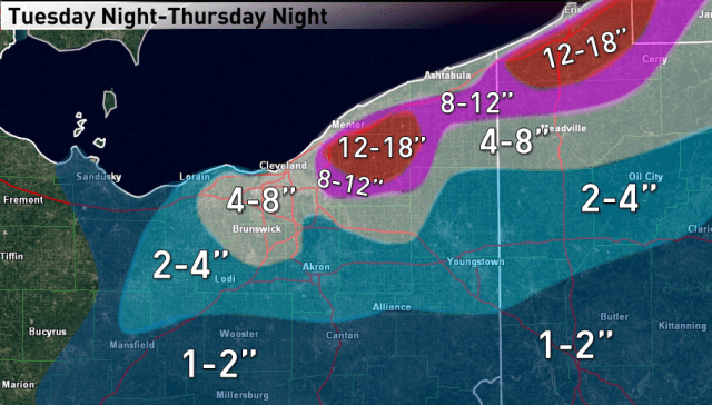
Total snows of over a foot seem quite likely over the higher terrain in the primary Snowbelt…from parts of eastern Cuyahoga County east through central and northern Geauga, far southern Lake, inland Erie and northern Crawford. Local amounts of over 18” are possible in northern Geuaga/far southern Lake as well as parts of inland Erie County where many phases of the event could perform well. The secondary Snowbelt in southern Cuyahoga, northern Medina and northern Summit Counties…as well as parts of Portage and Trumbull…could have a pretty good window Wednesday afternoon through Thursday evening and could see several inches. Local amounts exceeding over 8” in the true secondary Snowbelt (SW Cuyahoga, N. Medina, NW Summit) wouldn’t completely shocking of a good three-lake band can setup Wednesday night into Thursday morning. Due to a few windows for snow showers and possibly squalls to make it well inland, a couple to locally few inches may fall by Thursday night from the higher terrain near Mansfield east as far south as Stark and Mahoning Counties.
