

The preliminary storm reports compiled by the Storm Prediction Center (SPC) for Wednesday afternoon and evening depict quite a story: an extremely high concentration of tornado reports from northwest of Indianapolis through the Fort Wayne area all the way to near Toledo. Two tornadoes also occurred in southwestern Ontario, most notably an EF-2 in Windsor. Two long tracked supercells in particular produced extensive swaths of tornado damage, with many pictures and videos of huge, wedge tornadoes from both supercells. This was truly an impressive day given the region and time of year. We’ll be able to stack it up to other historical outbreaks across the region after damage surveys are completed in a couple days or so; the early eye test says that this is up there with the most intense tornado outbreaks across that region in the last few decades. Luckily, such an extreme event was well forecast, and people knew what to do…right?

Unfortunately, this outbreak was not really well anticipated by anybody. We were all caught with our pants down and that’s a crappy feeling. The Storm Prediction Center’s 12:30PM convective outlook had no risk for tornadoes noted anywhere near where the outbreak occurred, and only had a “marginal risk” (risk category 1/5) for damaging wind gusts and large hail for the region. Their outlook mentioned limited instability keeping any severe weather in the region from getting out of hand. This was just a couple of hours before tornadic supercells began developing over central Indiana; so, what happened?
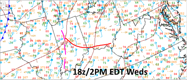
Surface analysis from 18z/2PM EDT Wednesday (courtesy of the WPC) doesn’t show any synoptic scale fronts directly affecting the outbreak region just an hour or so before things kicked off near Indianapolis. A cold front is well off to the west. The surface data plotted does reveal at least one, if not two mesoscale boundaries across Indiana; a wind shift from SW to due south extending from north to south across western Indiana, and what may be a diffuse warm front extending east from there. There’s little wind shift with the warm front, but there is an airmass change along it, and differential heating across a boundary is a source of frontogenesis and lift. It’s very possible this boundary was left by earlier convection/clouds and rain cooled air across northern Indiana.
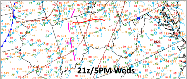
By 21z/5PM EDT, the wind shift appears to have edged east, while the diffuse warm front or differential heating boundary has nudged north. It is tough to tell where exactly the warm front is with very warm temps/dew points pushing up into MI, however there does appear to be a somewhat discernable wind shift near where I drew the boundary. The approximate point where the two boundaries meet near Fort Wayne happens to be where the most significant supercells were occurring at that time.

By 8PM during the evening, when supercells were occurring near and south of Toledo, and also in extreme southwest Ontario, the wind shift continues to nudge east, with the warm front/differential heating still evident east of the wind shift and near where the most robust supercells were occurring.
It seems that local wind shifts and enhancement of shear along the boundaries, along with convergence/lift along the boundaries, played a key role in this surprise tornado outbreak.
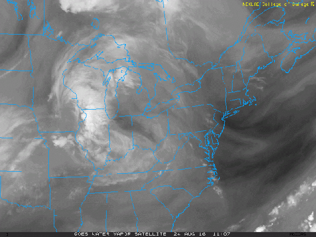
Water vapor loops from Wednesday morning and afternoon again show that the bulk of the larger scale weather features are fairly far north/west of the outbreak area; a jet streak across the central Plains is extending into the western Great Lakes, which if anything would put the outbreak area near the unfavorable right-exit quadrant of the upper level jet streak, where large scale sinking motion occurs. What is noticeable is it appears as though there’s a little upper level “curly cue” (vort max) left behind by a dying MCS over Illinois Wednesday morning that moves east into Indiana and sparks new thunderstorm development. It seems possible that this mesoscale convective vortex may have been key to this outbreak occurring, given that the unfavorable jet quadrant nosing over the region.
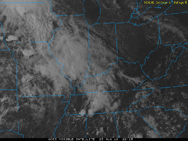
Visible satellite loops do reveal that a MCV was in fact left by a dying MCS over northern Illinois Wednesday morning, denoted by the loosely rotating cluster of cumulus clouds, with thunderstorm development occurring in earnest when the MCV and clear line of convergence (the wind shift discussed above) run into some sunnier and more unstable real estate in western Indiana. The visible loop also does show the differential heating boundary extended west-east away from the wind shift and retreating north quickly as storms blow up; it’s a fast loop so try not to blink, but notice the line of more robust cumulus developing over central Indiana during the early afternoon just south of the clouds over northern Indiana; this line moves north, suggesting we did have a differential heating boundary/sort of acting like a warm front over Indiana on Wednesday.
The combination of lift from a leftover MCV, some added shear from the enhanced low to mid-level flow from the MCV, convergence and local wind shifts adding low-level vorticity and locally enhanced low-level shear near the mesoscale boundaries seemed to be enough for supercell thunderstorms with tornadoes to occur over Indiana and eventually northwestern Ohio Wednesday afternoon and evening.
From a parameter stand point, let’s see how this all came together:

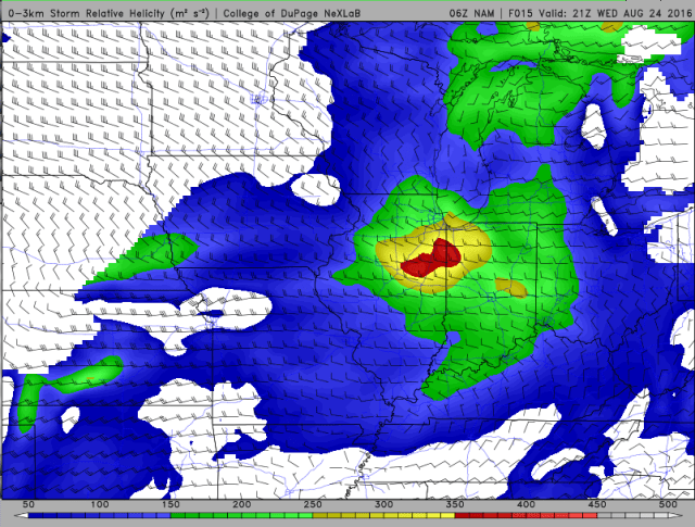
We’ll start with the Lincoln, IL observed sounding from Wednesday morning; this is just south of the MCV and is fairly representative of the air advecting into Indiana during the afternoon. A few things stand out; the big ones are very poor lapse rates, but good low-level moisture, characterized by precipitable water values of a little over 2” and dew points above 70F. The weak lapse rates make it harder to build instability and limit the cap, meaning storms will likely blow before you become explosively unstable. On the other hand, the rich low-level moisture can yield a couple thousand J/KG of MLCAPE with proper heating during the day, and also will insure that temperature and dew point spreads don’t become very large, keeping LCL heights lower. If you want tornadoes, anything over 1500 J/KG of MLCAPE is gravy. The wind profile is also decent, with over 200 m2/s2 of storm relative helicity, suggesting the increased potential for any updrafts to rotate.
Not a great sounding, but there’s a little bit to work with there.
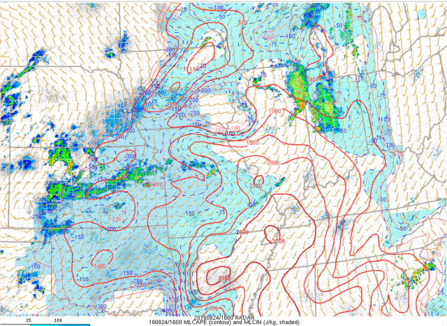
By 16z or 12PM EDT, here is a look at the analyzed MLCAPE across the region; this would’ve been the most recent data SPC forecasters could’ve glanced at before sending out the 1630z convective outlook pictured above. It doesn’t look great across the outbreak area, with less than 500 J/KG of MLCAPE (that’s not gravy) and stratiform rain moving in. Based just on this, I can see why the SPC thought northern Indiana and northwestern Ohio would stay too stable for a high end severe weather outbreak. Was there any sign that this would change?
My general rule of thumb when “guessing” if there will be recovery behind ongoing convection on a potential severe weather day is that you either have to have strong moisture advection or strong lapse rate advection to quickly recover and become unstable quickly after the stabilizing passage of early-day convection. In this case, 850mb (4000-4500 feet above ground level) winds were fairly strong out of the southwest, with good low level moisture advecting in on those winds. It was also fairly sunny (see satellite loop above) just south of the ongoing rain, so the strong low level flow undoubtedly helped advect in moisture and warmer temperatures as soon as the early round of rain moved east and dissipated. Without this robust advection, recover may have been less effective. With that said, would I have personally expected recovery behind the rain in northern Indiana this late in the day with rain/clouds still overhead? I don’t know, because I was at work and paid no attention during the lead up to this event (I was as surprised as everyone else), but my guess is I would’ve been highly skeptical of enough recovery to get a round of tornadoes in northern Indiana and northwest Ohio just a few hours after this time. But boy, did they ever recover…
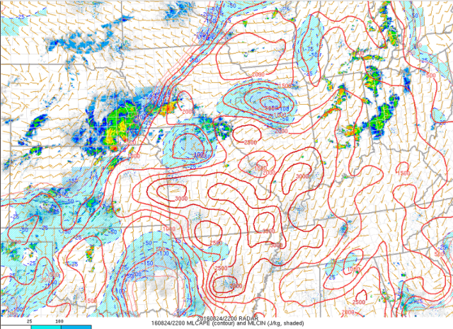
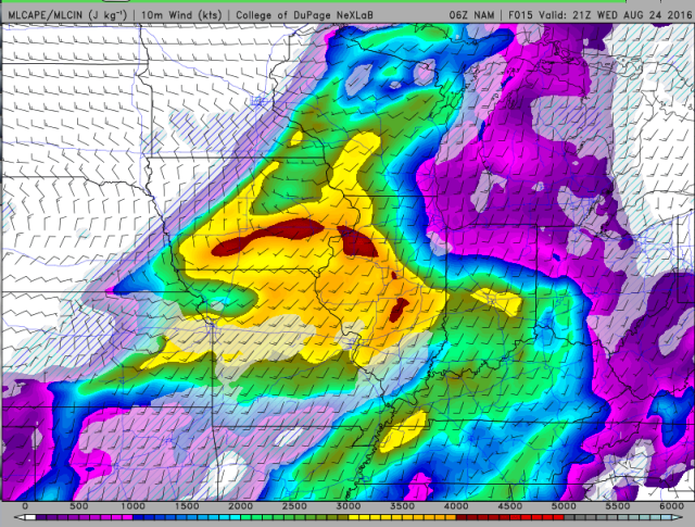
By 22z/6PM EDT, over 1000 J/KG of MLCAPE had built into northwest Ohio (and was still building a little farther northeast), with over 1500 J/KG (gravy!) over much of central and southern Indiana. Two long tracked supercells that produced multiple strong tornadoes in northwest Ohio were ongoing at this point. In addition to this adequate instability, other ingredients were also in place for this rash of impressive tornadoes to occur:

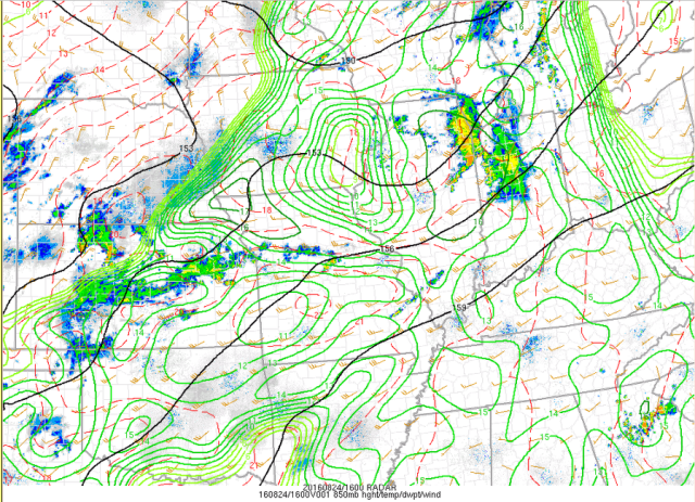
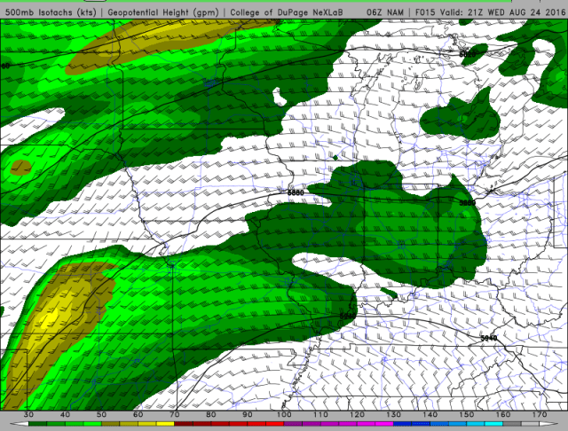
A mid-level speed max associated with the MCV caused bulk shear values to increase to 30-40 knots across the outbreak region; not the most ever, but certainly enough for supercells.
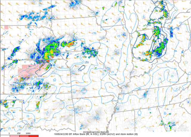
The combination of due south surface winds ahead of the wind shift running north-south across Indiana and west to perhaps a little north of due west winds aloft resulted in considerable low-level turning of the winds; the strong low level winds discussed above combined with this turning of the winds to create moderate to high “storm relative helicity” values across the outbreak area; basically, if you want dominant cyclonically rotating supercells with robust low-level mesocyclones (rotating updrafts), you want healthy helicity values. We had that Wednesday.

In addition to good instability, shear, and helicity, we had low “lifted condensation levels” (LCL) on Wednesday due to the rich low-level moisture. Tornadoes are thought to form when rain-cooled air in a thunderstorm’s downdraft is actually lifted back into a storm; low LCLs indicate limited potential for evaporational cooling below the cloud base in a downdraft, and hence suggest warmer downdrafts. Warmer air is more buoyant and has a better shot at getting pulled back up into a storm and allowing a tornado to form that very cold and dense downdraft air.
Essentially, the big ingredients needed for tornadoes all came together across parts of Indiana and northwestern Ohio today; enough instability, enough shear, and low LCLs. It was all basically a mesoscale accident, caused by an MCV bringing the shear and lift, and a moisture rich low level flow allowing for quicker recovery than normal behind early day rain/clouds. Mesoscale boundaries caused by differential heating and the MCV helped cause storm initiation, and likely caused locally enhanced low-level shear that only increased the tornado potential.
Was there any way to predict this seemingly perfect little environment in advance?
Taking a look at Wednesday’s early morning run of the NAM (courtesy of weather.cod.edu), the model does have a mid-level speed max associated with a bit of a vort max traversing the outbreak region during the late afternoon/early evening. When coupled with showing south-southwest surface winds and a 20-30 kt 850mb flow, the NAM did manage to develop an area of enhanced storm relative helicity in/near the eventual outbreak area with 12-18 hours of lead time…not a perfect representation of where the highest helicity ended up, but it is “in the ballpark”:
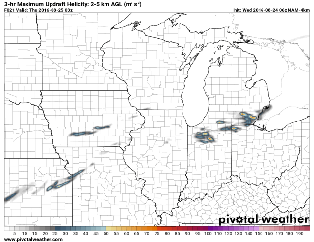
In addition to the reasonable shear forecast, the NAM wasn’t too bad in placing the instability gradient across the outbreak area; again, not perfect by any stretch (a little slow in building instability north/east), but it does have some juice. The NAM ended up being a little bit too veered with the surface flow, so it didn’t explicitly show a “very good” tornado setup…but it had some ingredients in place. The 4km NAM from early Wednesday morning even developed rotating thunderstorms Wednesday evening in the southern Great Lakes; again, not nearly a perfect representation, but it showed rotating storms “close” to where the outbreak ended up occurring:
So, at this point you’re going: “if the model showed this, why was there a 0% tornado probability in the SPC outlook?”
I didn’t forecast this event, I hardly looked at it, so I can only Monday morning QB at best here. My guess is the shoddy mid-level lapse rates and first round of rain/clouds made them think that instability wouldn’t build as quickly as the NAM projected. That is a totally reasonable expectation, because the NAM overdoes instability on a fairly frequent basis. With that said, this event did have subtle warning signs (that I picked up on perfectly when looking back on things after they happened!) that something more than just run of the mill storms were possible:
-MCVs are known to spark new rounds of storms due to the little shot of lift and shear they provide
-You can recover quickly when you have strong advection of either moisture or steep lapse rates
-Mesoscale boundaries can focus new storms and also locally increase shear
-Models will probably not depict mesoscale boundaries or convective artifacts like MCVs correctly; in situations where these types of features may play a role, be extra skeptical of a model’s output
-Low LCLs and strong low-level shear are a classic recipe for big tornadoes; if you get those two in place (the morning Lincoln sounding did at least hint at both) and get instability plus a trigger for storms, look out.
At the end of the day, this event was a fluke; an extremely memorable fluke, but a fluke nonetheless. We took a couple of possible ingredients and exploited the crap out of them when other, seemingly missing ingredients showed up to the party, and got a tornado outbreak out of it. If you forecast a tornado outbreak every time a few things “may but probably won’t” come together your false alarm rate will be very high, so don’t do that…but do be vigilant if certain ingredients quietly show up to the table, and be prepared to adjust on the fly if other ingredients start falling into line.

I’m a member of weather for all hoosiers and we were warned of the possibility of severe weather and tornados on wednesday on sunday evening or monday, can’t remember which blog. so fortunately we did have decent warning.
FYI, there were two tornadoes just E of the Detroit River as well – an EF1 in Lasalle (2 km track) and an EF2 in Windsor (8 km track). Dave Sills, Environment Canada
Thanks for the info on the tornadoes in Canada, I’ll edit the first paragraph to include mention of them. I saw pictures of the Windsor one, looked as large as a lot of the pictures out of Indiana and Ohio.