
As is always the case with tropical cyclones near the US, the following disclaimer is needed:
Although I’m a meteorologist, I’m not the official source for hurricane information. Follow the National Hurricane Center and National Weather Service at:
and
for tropical weather information and local forecast information that is updated regularly. Always follow evacuation orders put in place by local emergency management.
The vast majority of model images in this post can be found at http://www.tropicaltidbits.com

The Atlantic Ocean has three simultaneous tropical cyclones for the first time since 2013, and two of them are fairly close to the US. Hurricane Gaston has become the season’s first major hurricane in the middle of the Atlantic and is not a threat to the US. Tropical Depression 8 was declared Sunday morning and may bring rain and some wind to eastern North Carolina through Tuesday, before moving away to the northeast. Tropical Depression 9 is going to have a few days in the Gulf of Mexico to try to organize before moving into northern Florida around Thursday back out into the waters just off the Southeast coast by the end of the week.
Technical Discussion on TD 9:
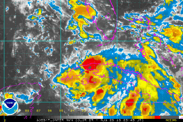
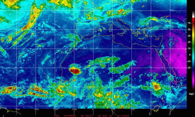
Tropical Depression 9 was formerly known as Invest 99L; the invest we’ve tracked for over a week that never could develop, until now. The invest was close to becoming a tropical storm on Wednesday as it passed close to Puerto Rico, but couldn’t quite close off its circulation. The system then received a shot of strong shear as it passed by Hispaniola, which combined with downslope off the high terrain into the low levels of the circulation and terrain enhancement of diurnal convection well away from the center to really gut what was 99L. The low level center was weakened and the system was extremely disorganized. Through the weekend shear has continued to plague the system, but a somewhat more humid environment and a slightly weaker interaction with Cuba allowed for just enough convection to fire near the low level circulation to strengthen the circulation and close it off on Sunday. Convection is still firing in a bursting pattern influenced by friction within the southern side of the circulation along the Cuba coast, and shear is preventing storms from lasting over the low level center before getting sheared off to the southeast. A mid-level spin evident on satellite south of Andros Island in the Bahamas indicates that the system is not vertically stacked, and further development will be slow until that can be corrected.

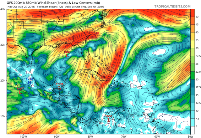
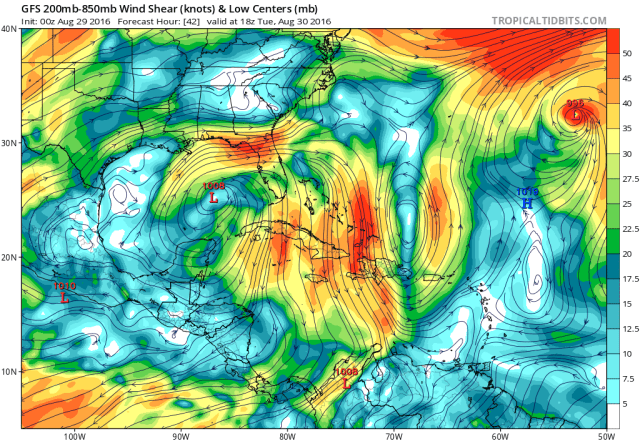
Water vapor imagery shows that a large upper level low, centered off the Southeast coast, is causing strong upper level northwesterly winds and hence northwest shear over TD 9. Dry air wrapping in on the west side of the upper low in the mid levels may also be limiting thunderstorms near and north of TD 9’s low level center. Another upper low is located over the western Gulf; this second low is moving west away from the depression. Should TD 9 survive and get into the region of lower shear and divergent upper level winds between the two upper lows over the central Gulf, its chances for organization would seemingly improve.
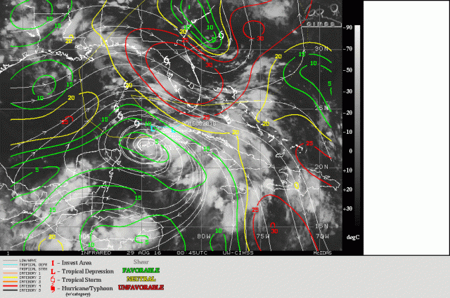
Shear analysis from CIMSS shows that the depression should be moving away from the strong shear near FL on the backside of the upper low and towards and area of more favorable upper level winds.
TD 9 is going to have a narrow window between Monday afternoon and Tuesday night to develop convection over its center, stack the low and mid-level center, and develop good outflow, as shear will increase around midweek as the cyclone turns northeastward towards northern Florida. Whether or not TD 9 can get its act together by the time the upper level flow starts increasing again near the cyclone will determine whether the system remains a strung out mess and hits Florida as a disorganized and weak tropical cyclone, or if it can hit as a more robust system.

By Monday evening, the GFS shows TD 9 moving west and away from the strongest shear on the backside of the upper low near the Southeast Coast. This could allow for convection to fire over the center Monday into Monday night and perhaps allow the organization process to begin.
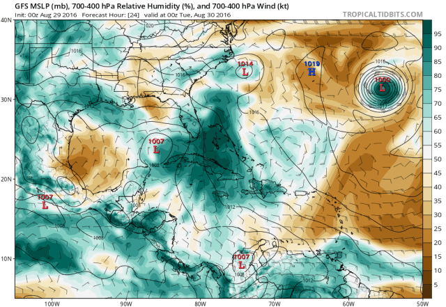
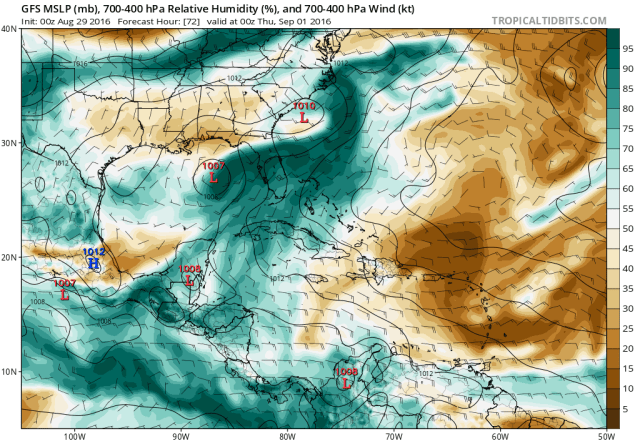
Drier air is evident north of TD 9 in satellite loops, with very little convection there, and the GFS suggests this will remain an issue as we move forward. By Monday evening, the model does verbatim have TD 9 within a pouch of higher moisture associated with the larger tropical wave that sparked the depression, however drier air still lurks over the northern Gulf. If shear does not abate as expected, this dry air may continue to get entrained into the depression and arrest further development/intensification.

By Tuesday evening, the GFS actually has TD 9 in a favorable upper level wind environment for further intensification; the cyclone is beneath an upper level anti-cyclone, providing for light winds aloft over the center, with stronger winds still persisting to the north and northeast of the cyclone, active as what could potentially be a good outflow channel. The key here is that the GFS can’t be off with the location of TD 9, and the cyclone needs to generate its own convection; if the cyclone is farther north and convection is weak, that shear would not allow for significant development. And, there’s still that pesky dry air issue over the northern Gulf:

Normally, if a tropical cyclone is vertically stacked and in a low shear environment, dry air intrusions are limited, even if the environment near the cyclone is fairly dry; however, it is worth noting that TD 9 has a large circulation which makes it more prone to pulling in some dry air…and again, it is not vertically stacked or well organized at this time.
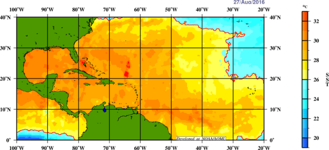
IF…IF TD 9 can take advantage of the anticipated lower shear/good outflow environment Monday and Tuesday and limit dry air intrusions, the waters over the eastern Gulf are sitting on either side of 30C/86F, which is very warm and can support an intense tropical cyclone. Heat content is a little bit less impressive over the eastern Gulf, meaning a slow moving system could upwell cooler waters relatively quickly. It seems like TD 9 should continue moving at a slow to moderate pace through Wednesday, before accelerating to the N/NE on Thursday:

Overall, there are many mixed signals on the environment TD 9 will encounter over the next 48 hours/through Tuesday. We’ll have shear that will allegedly weaken, but a small error in the track forecast of the TD could mean more shear than expected. Dry air will be present north of the cyclone; normally, in a low shear environment that may not mean much, however the TD’s large size, poor organization, and risk of slipping under higher shear mean there is definitely a heightened risk of dry air continuing to affect the system and slow development. IF the other questions are overcome, waters support a stronger tropical cyclone, but only if it keeps moving.

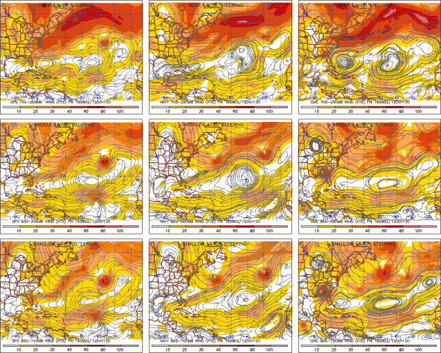
Currently, low level ridging located north of TD 9 is steering the depression almost to the due west. This general motion will continue for another couple of days, except the depression should turn more WNW as it moves west of the center of the ridge.

By Wednesday into Thursday there is good agreement on a trough diving into the Northeast, pushing a cold front south and weakening the ridging north of TD 9. This will allow the depression to be steered around the western periphery of subtropical ridging over the central Atlantic, causing a turn to the NNE Wednesday into Thursday. This turn should allow TD 9 to get fully caught up in a weakness in subtropical ridging, causing it to continue to move NE between the subtropical ridge to the SE and trough to the N:
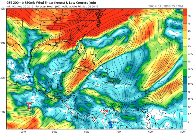
This northerly turn on Wednesday and Thursday will take TD 9 towards the higher shear and drier air over the northern Gulf; how much the system can intensify between now and Wednesday will really determine how it does when the turn north occurs.
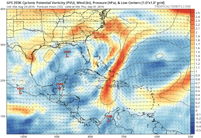
The shear will be caused by a TUTT axis between the two aforementioned upper lows currently affecting the environment TD 9 is in. By Wednesday and Thursday, this TUTT axis is still clearly demarked by enhanced vorticity at the top of the troposphere, and as TD 9 moves farther north it gets closer to this TUTT axis and increased shear. The more typical shear forecast plots show this…TD 9 is still near the center of an upper level ridge, but strong shear lurks over the northern Gulf:
Whether or not organized and robust convection is occurring over the center of TD 9 at this point (Wednesday) is critical to how the TUTT axis and shear affect the cyclone; strong convection will feature stronger upper level winds blowing away from it, which could fend off shear. In addition, height rises caused by the latent heat release within the convection and the resulting anti-cyclonic vorticity generation could literally push the TUTT axis out of the way and weaken it. If this occurs, shear would remain lower over TD 9, but the remnant TUTT axis to the northeast would aid in strong outflow over the storm. It really is a bit of an all or north proposition. Oh, and dry air will still be an issue:
As the trough dives into the eastern US by Thursday and Friday, a jet streak will likely develop over the SE and off the East coast, which would really increase the upper level southwesterly flow in the general vicinity of TD 9:
This again can go one of two ways…a weaker, struggling system likely gets sheared even more. The strong large scale ascent in the right-entrance quadrant of the jet streak may cause pressures in the system to fall a little bit, but a weak system wouldn’t positively interact with this jet streak. A strong system would likely not be sheared immediately and would see a positive interaction, possibly strengthening up until landfall. Again, a lot of this is an all or nothing proposition.
As this system gets whisked away to the northeast Friday and Saturday it may pass near the southeast US coast and bring rain/gusty winds. The Gulf Coast should be tropical-cyclone free for Labor Day weekend. Here is a look at the tropical cyclone track models for TD 9:
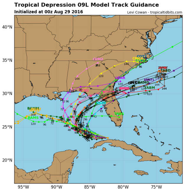
Based on the steering current comparison plots on E-Wall, it looks like the ridging in the upper levels is weaker than in the low levels…this means a stronger system may turn N and then NE quicker than a weaker system. With this said, TD 9 has been hugging the Cuban coast more than modeled, possibly due to frictional convergence near the coast. This may cause models to be slightly biased too far to the “right” with TD 9. The 0z GFS ensembles show a more realistic motion near Cuba in the short term and show a slightly wider turn, taking TD 9 in farther north than a lot of the ATCF models shown above:

The basic summary here is unless TD 9 really busts hard in the 24-48 hour period and keeps heading due west instead of turning more NW, we should see an eventual landfall in Florida somewhere between Tampa and the FL/AL boarder. Once this thing starts accelerating to the NE it should continue to head that way as it gets picked up by the trough and westerlies…so it’ll either bust left of the models and stay inland over the SE, or emerge back over waters and parallel the Carolina shoreline. I don’t currently foresee a situation where this emerges off of Florida and then turns north and makes a second landfall in the Carolinas. Here is my hastily drawn track idea:

I have a slightly wider turn owing to a track closer to Cuba in the short term, but the logic is similar to what the global models do in terms of turning it to the northeast.

If you put me on the spot and asked me how strong I thought this would get, my gut feeling ever since this system almost died north of Hispaniola a few days ago has just been “no.” I continue to lean against significant organization and intensification prior to landfall for a few reasons. I do acknowledge that if this system can really organize and perhaps contract a bit by Tuesday night/Wednesday morning that it may have a positive interaction with the increasing southwesterly upper level winds and intensify into a hurricane before hitting Florida…however, for that to happen, we need shear to relax in the immediate future, convection to fire over the center, a new mid level center to form, and see dry air mix out. Given the current complete lack of organization and broad size of the system increasing the likelihood of dry air intrusions even if/when shear decreases, that just seems like a tall order. My guess is we see a little organization by Wednesday with shear then increasing and the system not being able to fight it off, capping the intensity at a weak to moderate and fairly disorganized tropical storm by landfall. We should have a good idea by Monday night or Tuesday morning on whether or not we’ll see enough organization to maybe fend off the shear later in the week.
It is important that 4/20 of the 0z August 29th GEFS members deepen TD 9 to sub-1000mb before the Florida landfall…approximately 15-20% of the 12z August 28th ECM ensemble members deepen TD 9 to sub-1000mb before the Florida landfall…and approximately 1/3 of the intensity models pictured above get TD 9 up to hurricane strength at any point. This means the clear majority of guidance is shying away from a more explosive solution. Given the pros and cons discussed above…there is a non-zero but still well less than 50% chance of the stronger outcome, but more signs seem to point towards a weaker storm heading into Florida.
The bulk of the wind and rain may be on the east/southeast side of TD 9’s circulation, meaning impacts on the Florida peninsula may be increased well to the right of TD 9’s track across the state.
Once the system gets off the Southeast coast by the weekend, strong large scale ascent from the jet streak could allow for deepening, and may cause the system to slowly lose tropical characteristics as it quickly moves away to the northeast.
Quick look at TD 8:

Tropical depression 8 is not an organized tropical cyclone. It features a completely exposed low level center with minimal shower activity currently. This is due to strong southeasterly shear on the west side of an upper level low centered to the west (the same low shearing TD 9) and a fairly dry atmosphere.
The shear should temporarily relax Monday night into Tuesday off the North Carolina coast before re-intensifying out of the west/southwest Tuesday night and beyond. TD 8 has a more vigorous low level circulation than TD 9 and is also smaller; it only has 24-36 hours of weak to moderate shear to organize before it likely gets blasted to pieces Wednesday into Thursday. Given the system’s smaller size and potent circulation, that could easily be long enough for it to intensify into a tropical storm before getting blown apart. Given the dry air surrounding the system currently, its total lack of convection, and fairly short window, TD 8 probably won’t intensify past a weak to moderate tropical storm.
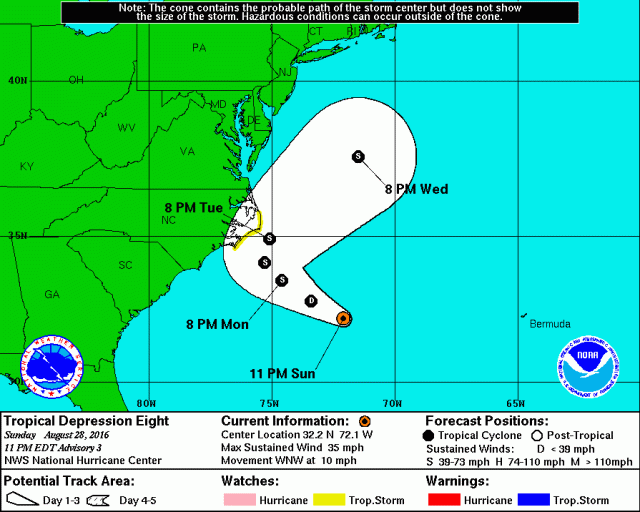
The system will, like TD 9, also turn northeasterly by later in the week as troughing dives into the eastern US. In the meantime, it will get rather close to the North Carolina coast/Outer Banks. The system is fairly small and weak, however moderate rainfall amounts and tropical storm force wind gusts could occur over eastern North Carolina depending on how close TD 8 can get to the coast. For this reason some tropical storm watches have been posted. Here is the NHC forecast for TD 8:
Long Range:
There has been a strong and consistent signal from the GFS, Euro, and most ensemble members from both suites on the next African wave developing in a few days as it heads west across the Atlantic. There is a very large plume of dry, mid-level air coming off of Africa along/ahead of this wave, which when combined with some westerly shear may limit how quickly this wave develops once it emerges. Given the strong model signal it will have to be watched…but it may not blow up as quickly as Gaston did.
Large scale ascent is forecast still to move into the Atlantic basin for the first couple weeks of September. This will likely mean the relatively active tropics will continue for at least another 2-3 weeks. The ensembles are insistent on strong sub-tropical ridging Atlantic-wide in the mid-range, which means any tropical systems may be less inclined than normal to recurve into the open Atlantic. We still have a ton of time to monitor this watch for changes, but it’s an interesting combination of factors for early to mid September.
For now, let’s get through TD 8 and TD 9.
