
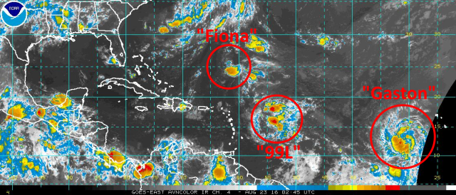
We have three tropical systems in the Atlantic Ocean right now; two of them are designated tropical cyclones (Tropical Depression Fiona and Tropical Storm Gaston), one of them is still not designated (Invest 99L), and only one may have an impact on the United States, and even the odds of that happening are much less than certain.
Tropical Depression Fiona:
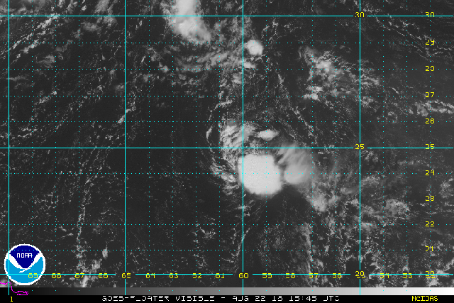
Tropical Depression Fiona is currently the longest lived tropical cyclone of the 2016 Atlantic Hurricane season at almost 6 days old, however it is less than impressive. The above satellite loop from Monday afternoon shows that Fiona is only producing bursting convection that is quickly getting blown off to the east of the center of circulation by strong westerly wind shear. Dry air near Fiona is also helping to limit the intensity of said convection. Fiona still has a closed circulation and still is producing deep convection, and thus is still a tropical cyclone, however it is barely hanging on.
Water vapor loops show the upper level low/TUTT just north-northwest of Fiona that has been providing for the strong westerly shear. As Fiona moves west-northwest into the trough axis, the shear should subside a little bit around mid-week, before picking back up as another upper level trough moves off the East Coast. The upcoming relaxation of the shear may allow Fiona to hang on as a weak tropical cyclone for another couple or few days until more shear likely finishes the storm off.
Because Fiona will be so weak, it’s very possible the remnants hang around between the Southeast Coast and Bermuda for several days as opposed to re-curving…however, the system will be weak and the airmass looks dry, so re-intensification off the Southeast Coast appears unlikely. As I said a few days ago, Fiona doesn’t look to really be a threat to land.
Tropical Storm Gaston:

Although Tropical Storm Gaston will in all likelihood not directly threaten land, with the small possibility of Bermuda being an exception to that, it will likely become the strongest tropical cyclone in the Atlantic in 2016 thus far (not a high bar), and may become the first major hurricane of the season.
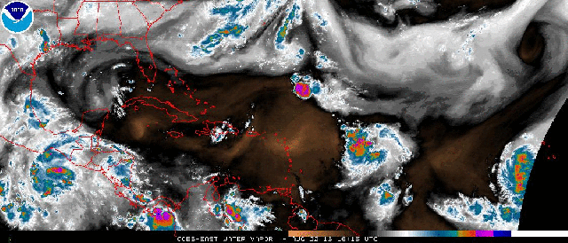
Although convection with Gaston isn’t extremely widespread at this time, it already shows signs of organization with a curved band west and south of the center. The above infrared satellite image and earlier water vapor loop also show signs of poleward and equatorward outflow with Gaston.

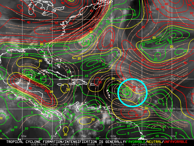
Water vapor imagery doesn’t suggest strong shear in the immediate vicinity of Gaston, and CIMSS shear analysis confirms this, with an upper level anti-cyclone directly over the cyclone providing for divergent upper level winds (good outflow) and weak shear over the cyclone. Water vapor does show very dry air ahead of Gaston; typically, dry air intrusions are limited as long as shear is minimal.
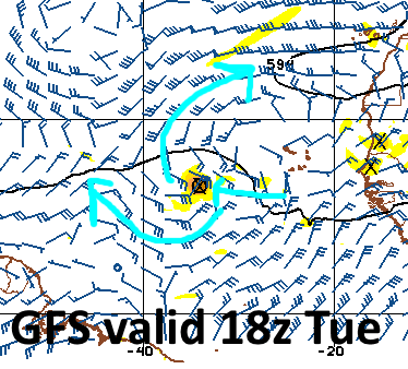
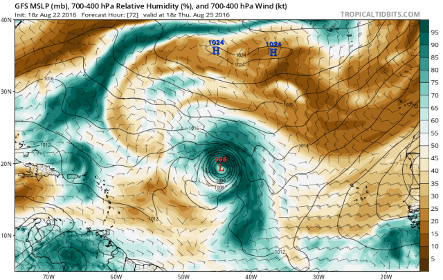
The GFS suggests that the upper level anti-cyclone should remain relatively coupled with Gaston, or perhaps become centered a little bit east of the cyclone. If this comes to pass, some weak to moderate easterly shear may occur, however outflow would remain good (note the upper level winds moving away from the cyclone on the GFS) and the shear wouldn’t be enough to prohibit some further organization, so gradual intensification over the next couple of days seems reasonable. Good outflow and some signs of convective organization suggest further intensification, while some shear and nearby dry air will likely keep the intensification gradual in the short term. Gradual intensification for a couple of days may already bring Gaston up to strong tropical storm or minimal hurricane strength by Wednesday.
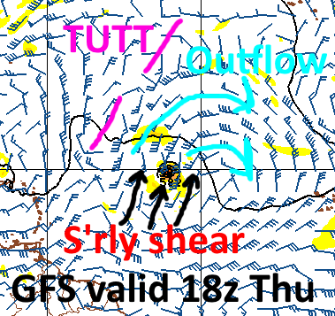
By the time we hit Thursday, Gaston is expected to encounter moderate southerly shear as it approaches a TUTT axis over the central Atlantic. Outflow is expected to remain strong, and the southerly outflow may initially resist the shear ahead of the TUTT, however the flow around the TUTT will likely be strong enough to overpower the equatorward outflow for a day or two towards the end of the work-week. With outflow remaining strong to the north, it’s possible Gaston retains hurricane strength despite this shear, however I’d anticipate intensification to halt, with some weakening being possible around the end of the week.
Although Gaston is a large system, it will still be plowing through a relatively dry airmass later in the week. Fiona and Invest 99L have moistened the environment some, however there will still be enough dry air near Gaston later in the week for possible intrusions, especially if shear increases. Because of this, intensification halting and possibly a little bit of weakening appears to be likely in the Thursday-Friday timeframe as the TUTT induces moderate southerly shear on the tropical cyclone.

As we head into the weekend, the GFS weakens the TUTT enough and allows shear to abate, causing outflow to begin improving south of the storm, while maintaining to the north of the storm. This low shear/good outflow environment over warmer than average sea surface temperatures will in all likelihood allow for intensification to resume in earnest by Sunday-Monday with Gaston.

The Euro shows a similar environment on Sunday, with Gaston in an area of low shear, with good outflow to the north and south of the system.
Both the GFS and Euro deepen Gaston considerably into early next week, which seems possible with a few days of a potentially low shear/strong outflow environment over reasonably warm waters. There is a distinct chance that Gaston becomes the first major hurricane of the 2016 Atlantic hurricane season around Monday or Tuesday of next week. There is near unanimous agreement among the latest GFS ensemble runs on considerable deepening of Gaston by early next week:

Although I can’t show them, the Euro ensembles also have a number of members that deepen the cyclone considerably.
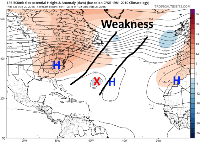
A weakness in the sub-tropical ridging in the central Atlantic will in almost all likelihood allow Gaston to re-curve well out to sea early next week. It may brush Bermuda, but unless 1) the cyclone deepens much slower than expected or 2) the ridging is much stronger than modelled over the central Atlantic, the storm won’t make it past 60 or 65W before recurving.
Invest 99L:

Invest 99L still has a ways to go before becoming a tropical cyclone. I didn’t expect development through the weekend due to shear, and for a good portion of Friday and Saturday, the tropical wave was devoid of deep convection. Since Sunday, disorganized deep convection has been more persistent over the wave, however it isn’t at all organized. Notice how the convection is still pulsing and not really developing in any sort of coherent, organized pattern.
99L was affected by northeasterly shear through the weekend, which along with very dry mid-level air prohibited any organization. The wave has become a little more co-located with an upper level anti-cyclone, causing shear to diminish some. The upper level winds actually don’t look unfavorable over the next couple of days on the GFS model, as the wave tracks beneath an upper level anti-cyclone:

The hurtles for 99L over the next two or three days will be very dry air, and eventually potentially some land interaction. Water vapor imagery shows very dry air around and ahead of 99L; decreasing shear would normally limit dry air intrusions, however the large size of 99L, immediate proximity of dry air, and abundance of dry air in the circulation already may make the process of purging dry air from the circulation slow/difficult. Given the current disorganization of 99L, and the fact that we may not see sustained bursts of convection over the next couple of days due to dry air, I’m now skeptical of the invest becoming a tropical cyclone before affecting the northern Lesser Antilles and Puerto Rico:

Currently, the tropical wave is being steered to the west-northwest on the south side of expansive low-level subtropical ridging across the Atlantic. This general motion will continue over the next couple of days, as the weak system won’t be picked up by the small weakness in the low-level ridging over the central Atlantic:

This motion will take the tropical wave over the northern Lesser Antilles and very close to the US Virgin Islands, Puerto Rico, and possibly Hispaniola. How 99L interacts with Hispaniola will likely have a significant impact on whether or not the system develops into a tropical cyclone that threatens the US next week, as a weak system running into the mountainous terrain in a less than perfect environment may result in the system not surviving/developing further.

Our current tropical forecast model tracks almost unanimously trek 99L north of Hispaniola, however it is worth pointing out that very weak systems often follow the east-west trades and track a bit farther south than modelled. Also, even if the system is on track to pass north of Hispaniola, sometimes convergence or upslope caused by the rough terrain can focus convection over land and “pull” the system south into the island, literally causing it to get “caught up” in the mountainous terrain.
Despite these concerns, our models have consistently taken 99L north of Hispaniola, so for now that is the solution I’m leaning towards…however, it’s not a guarantee, and future development of the system depends on how it interacts with Hispaniola. Given the only marginally favorable environment over the next 60-72 hours (low shear but very dry air) before the system approaches Hispaniola on Thursday, and current disorganization, there’s probably a less than 50% chance the system become a tropical cyclone before passing Hispaniola. If it does develop, it will probably not be stronger than a weak tropical storm by then.
IF 99L passes north of Hispaniola and isn’t caught up in the higher terrain, the environment will remain OK with low shear, some dry air, but warm SSTs beneath the system. If 99L can survive it’s close encounter with Hispaniola, I do think it has a better shot at developing into a tropical storm as it approaches the Turks and Caicos and eastern Bahamas. The environment around Sunday-Monday won’t be perfect over the Bahamas, as a trough moving off the East Coast may bring a little shear and dry air near 99L, assuming it’s over the Bahamas:
Some shear along/ahead of the trough and dry air behind it may prevent much intensification through the weekend, however, there are hints at a more favorable environment developing by Sunday and Monday over the Bahamas/Florida, IF the system can survive that long:

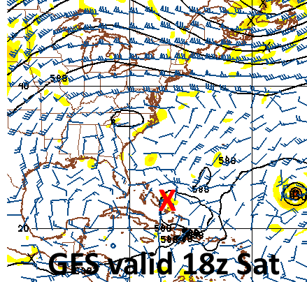
Note the diverging upper level winds in the region and weak shear, indicating any system would be able to potentially generate deep convection and organize. There’s good agreement on upper level ridging building over the southeastern US this weekend into early next week, so a system around the Bahamas may slowly drift or possibly move west, as opposed to escaping out to sea. The only way the system recurves north and either clips the Carolinas or moves out to sea is if it intensifies much quicker than expected through Saturday. Because of this, 99L is the system to watch for possible impacts to the US…but, there are multiple obstacles for the system to overcome through Saturday, so it is too early to raise any sort of alarm. It is important to note that out of all of the hurricane models, global models, and the ensembles, that probably about 20% of all guidance actually gets 99L to near the Bahamas and then develops it into a decent tropical cyclone. The meteorology suggests that is a possible solution, however, there are many cons to that solution, and it’s important to keep in perspective that most guidance actually doesn’t show that occurring. With that said, the possibility is there so it bears watching. We’ll know more after it passes Hispaniola.
