
The thoughts in this post are mine and are not considered official. Official forecasts can be found at:
www.nhc.noaa.gov (Hurricane Center)
www.weather.gov (National Weather Service)
http://www.prh.noaa.gov/cphc/ (Central Pacific Hurricane Center)
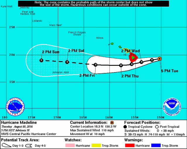
Hurricane Madeline is tracking towards Hawaii as a hurricane. The storm is gradually weakening, but is expected to pass close to the Big Island (Hawaii County) Wednesday afternoon and night as a hurricane. Hurricane warnings are in affect for the island; due to the rare nature of hurricanes directly impacting the Hawaiian Islands (especially the Big Island), a pass as close to the island as currently forecast of a category 1 hurricane could have a major impact on the island’s infrastructure. Mud slides/inland flooding, storm surge/dangerous waves on the eastern side of the island, and strong and damaging winds, particularly on the eastern side of the island and on eastern facing terrain, are possible on the Big Island as Madeline passes.

In the Gulf of Mexico, Tropical Depression 9 continues to slowly organize, and is beginning to turn towards the north. The storm will turn north-northeast over the next two days and accelerate towards the Big Bend in northern Florida. A hurricane watch has been issued for this region. Gusty and potentially damaging winds are expected near and to the southeast of the storm’s track across Florida, along with heavy rain and some tornadoes. The storm’s trajectory and large size will likely cause a moderate storm surge along a large portion of the Florida coastline from Apalachicola to near Tampa. Some areas may see water rises of 2-4 feet, possibly higher if the system can become a hurricane before landfall. There is increasing concern for a glancing blow to the Southeast coast as Tropical Depression 9 accelerates northeast Thursday night into Friday. Monitor local forecasts if you are in the path of Tropical Depression 9 and always heed any evacuation orders given by local emergency management.
While we’re here, Gaston has become an absolutely gorgeous category 3 hurricane in the middle of the Atlantic:

My Forecast/Meteorological Discussion on TD 9:

TD 9 has seemingly been a tropical depression forever, however if recent trends continue that will not last for much longer. Aircraft reconnaissance from Tuesday evening show that the low level center of TD 9 is under the northern side of some bursting convection. The 10PM CDT/3z advisory position was 24.3N, 87.8W, which is underneath a recent convective blowup. The mid level center is still decoupled from the low level center, and can be seen spinning away south of the low level center location on this satellite loop, however shear has lessened…if convection can consistently fire over the low level center, a new mid level center will form over the low level center, which would allow for more substantial intensification to occur.
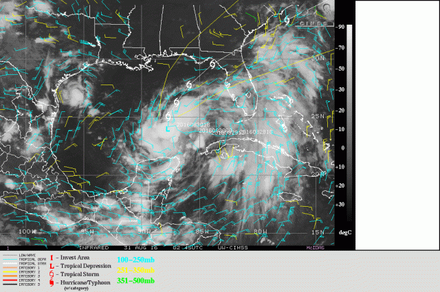
A wider shot of TD 9, along with upper level winds overlaid, shows that TD 9 has edged under an upper level anticyclone, allowing for divergent upper level winds and low vertical wind shear over the cyclone. There is strong outflow to every quadrant of the storm except for the northwestern quadrant, and even here there are recent signs of some outflow trying to develop.

Water vapor images show that the upper lows that previously imparted strong shear on TD 9 are now far enough away from the cyclone that their shear is minimal, with the faster upper level winds around them contributing to divergence over and upper level outflow from the depression. There is still very dry mid level air north and west of the depression, and I believe that this is still affecting the cyclone and causing the convection to burst, as opposed to being more sustained. Until shear can relax completely and the vortex can become vertically stacked/aligned, dry air intrusions may continue to limit how quickly TD 9 can intensify.

The most recent microwave image as of this writing, from earlier Tuesday evening, shows that there may be signs of some curved banding developing with TD 9. The center was near the northeastern edge of the ball of convection at this time; curved bands would promote more organized and persistent convection that would stack the centers of TD 9 and limit dry air intrusions, if this banding can develop. The question is, when will the centers of TD 9 align, and how much time will there be to strengthen?

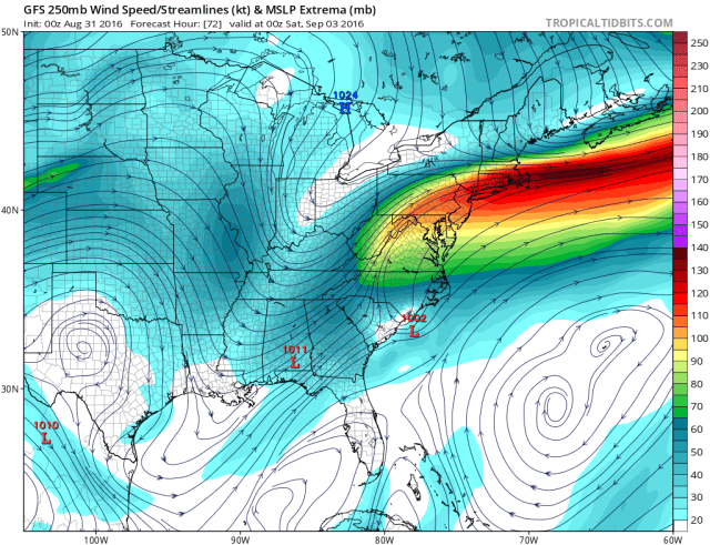
The very near term GFS forecast MSLP and wind field shows that TD 9 is a very broad system; 1004mb, the 10PM CDT advisory central pressure is rather low for a tropical cyclone that doesn’t have tropical storm force winds, and this is due to the broad nature of the cyclone limiting the pressure gradient and hence wind speeds. The broad nature of the system, which has been ID’d as a possible issue in previous posts does two things: it makes it easier for dry air intrusions to occur, and also makes it harder for the system to really “tighten up” and intensify, as a much larger mass of air is rotating. TD 9 appears to be a part of a much broader surface trough of low pressure, extending northeast and including TD 8 off the NC coast.

The GFS fields also show what water vapor suggested, that dry mid-level air is getting wrapped into the northern/western side of the circulation. Not only that, but the aforementioned trough extending northeast of the cyclone appears to be focusing moisture convergence on the southern and eastern side of the circulation, with divergence on the northern and western sides. The combination of dry air and sinking motion on the northwestern side of the cyclone will likely make it difficult for convection to fire here in the near-term. Although shear has decreased, the convection continuing to fire only on the southern and eastern sides of TD 9 may make it hard for the centers to align vertically in the near term. Until the circulation can tighten/separate from the larger trough, and mix out some more of the dry air, it will probably remain lopsided.
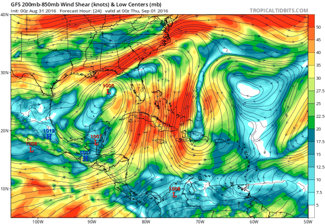
If you’re gunning for a stronger storm (if you’ve read this far you probably are), the “good” news is that TD 9’s slightly slower motion in the Gulf over the last couple of days compared to expectations, along with stronger shear being a bit farther north than previously modelled, will keep shear weak over the system through Wednesday night, before increasing on Thursday. The GFS shows TD 9 remaining right under an upper level anti-cyclone Wednesday, with minimal shear over the system and great outflow to the north and east.
Normally, when shear and dry air are both plaguing a tropical cyclone and the shear then weakens considerably, the dry air issues can then become resolved within 24-36 hours as the cyclone becomes stacked and develops an inner core that the dry air can’t easily penetrate. In this case, due to the cyclone’s large size and moisture convergence south and east of the low level center, I believe we may have a hard time quickly seeing TD 9 become more symmetric, meaning the centers may not quickly stack and that dry air may continue to cause the convection to burst. My guess is it will take near the longer end of the 24-36 hour range to get TD 9 in order now that shear has finally abated; this means it may have a window to intensify more substantially by Wednesday night or early Thursday. Before then, too many potent thunderstorms are going up relatively close to the low level center for this not to intensify a little bit into a tropical storm, but I don’t expect a big drop in pressure or uptick in winds through Wednesday afternoon.

By the time we hit Thursday morning, which is probably close to how long it will take to start getting TD 9 more vertically aligned, if not slightly longer, we can see that the cyclone is beginning to approach northern Florida, with southwesterly winds starting to pick up in the upper levels as a trough drops into the eastern US. How this initial increase in shear affects the cyclone will depend on how organized and convectively active the system is; if robust convection is firing over the center, outflow would likely be strong enough to fend off this shear for a period of time. Instead, the increasing southwesterly winds aloft and divergence under the right-entrance quadrant of the jet streak would act to help deepen the cyclone further as it moves towards landfall.

By this point, the GFS suggests that TD 9 may finally begin trying to tighten up and separate from the larger trough axis; given how embedded it is within the trough axis right now and likelihood that the trough axis itself will contribute to arresting the development of TD 9 over the next day or so, it’s probably reasonable to expect that it will take at least this long for TD 9 to separate and try to wind up a little bit faster. Dry air will still plague the northwestern side of TD 9 as it approaches Florida on Thursday, so we’d need TD 9 to completely separate from the larger trough and see the winds around it become more circular; otherwise, moisture convergence and the most active convection may remain on the eastern/southern side of the cyclone, while the northwest side battles dry air and subsidence. This would limit how quickly TD 9 can intensify while moving towards its first landfall in northern Florida, and would possibly keep the centers from ever becoming 100% vertically stacked.
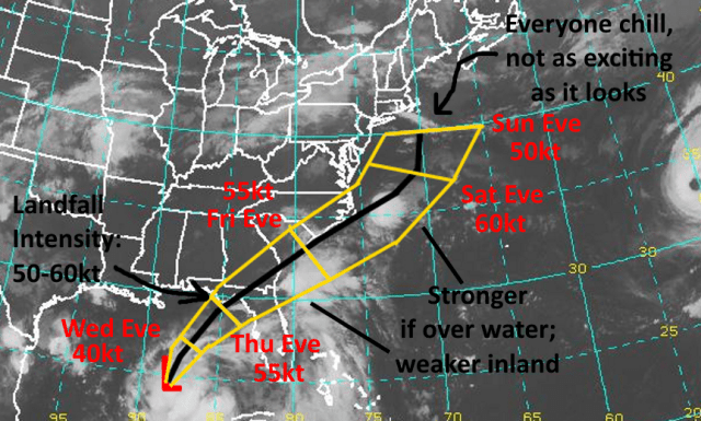
Given all of this, I still believe that TD 9 will most likely remain below hurricane strength for its Florida landfall. I expect a little bit of intensification during the day Wednesday as the system continues to slowly organize, with perhaps a modest uptick in the intensification Wednesday night into Thursday as the system may finally start getting its act together just prior to landfall. I am increasing my expected landfall intensity some from my forecast 2 days ago to 50-60 knots (60-70MPH). This is near hurricane strength…if TD 9 can find a way to organize faster, which is the less likely solution given the current negatives, it is still within the realm of possibility that it becomes a category 1 hurricane before hitting northern Florida.

Regardless of whether or not TD 9 is a 65MPH tropical storm or 80MPH hurricane when it hits Florida Thursday evening, an extended S-SW fetch over a wide area of the eastern Gulf will really pile up water from Apalachicola down towards Tampa, so a large area may see a 1-3 foot water rise…with local rises of 3 to 5 feet possible just right of the center and also where the shape of the shoreline helps funnel water in. A lopsided system with most of the active weather on the right side of it may increase the risk for some tornadoes across the Florida peninsula on Thursday and Thursday night.

The track forecast over the next 48 to 72 hours is rather straight-forward…as TD 9 begins slowly moving north and northeast on the backside of a subtropical ridge over the western Atlantic. A trough digging into the eastern US will ensure a weakness exists in the ridging, which is where TD 9 will go. As the trough dives down the flow will increase, and TD 9 will see its speed increase some as well by Thursday and Friday. TD 9 is taking a slightly wider/slower turn over the Gulf than modeled a couple of days ago, which is what my forecast called for, so as far as I’m concerned things are still on track up through the Florida landfall.

After the Florida landfall, things get a bit dicier. Originally, the trough over the northeast was expected to dive in much more aggressively and a good bit farther west; this would have kicked TD 9 east, off the coast near Savanna, and out to sea. Now, the trough isn’t expect to be far enough south to really give TD 9 a kick after it makes landfall, meaning it may move more northeast and parallel the Carolina coast, as opposed to heading more directly out to sea.

The latest run of the hurricane track models show TD 9 moving offshore near Savanna, GA and passing close to but just off the SC and NC coasts. The 0z GFS and Euro both move the storm along the SC coast and either on or just immediately off the NC coast. Given the wider turn over the Gulf allowing for a farther “left” track in the short term, and the continual trend to weaken/slow the incoming trough, there is a very real chance the storm tracks along or farther “left” than the track models above, close to the GFS and Euro, and ends up right along the Carolina coastlines.
So far in TD 9’s life, and likely through its Florida landfall, the northwest or “left” side of the storm has been the weak side. This will likely change as TD 9 tracks very close to or over the Carolinas.
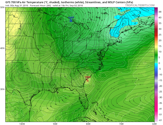
As the trough moves across the Northeast, a shot of cooler air will move south and impinge upon the very warm and humid air associated with the tropical system. This clash of airmasses will cause frontogenesis on the north side of the tropical system, with signs of mid-level deformation also present north and northeast of the cyclone. At this point, the cyclone won’t be fully tropical as baroclinic influences begin taking hold, however it really won’t matter; all of this additional lift on the north side of the system will likely wring out very heavy rain over the Carolinas Friday into Saturday. Luckily, TD 9 will be moving by this point, but some flooding is possible.
Another thing to consider is the very strong shot of upper level divergence that will be over the cyclone as it moves by the Carolinas as a result of a right-entrance quadrant of a jet streak on the south side of the Northeast US trough. This will evacuate air away from TD 9, promote convection over water, and also promote surface pressures maintaining or even lowering. If TD 9 can emerge over water as it passes by the Carolinas it would likely intensify into a hurricane (or hurricane intensity sub-tropical cyclone)…even if it is sitting on the shoreline, it may at least maintain as a strong tropical storm. This means that winds could also be strong over coastal SC and NC as TD 9 goes by. If the system is on the coast or inland, onshore gusts in excess of 60MPH would be likely ahead of the storm…if the storm is just off the coast winds will be offshore and lighter, but still could gust over tropical storm force over the coastal Carolinas. The impacts over the Carolinas look minor as far as tropical systems go but still notable overall. Some surge would also occur should the center be a little bit inland and allow for the winds to come onshore.
With all of the baroclinic processes affecting the cyclone as it passes by the Carolinas it likely would not be purely tropical; tropical convection would still occur near the center if it emerges over water, however the system would not look like a classic, compact tropical cyclone…most like a strong Nor’ Easter with tropical convection near the low.

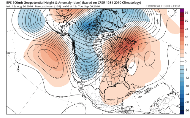
Unfortunately, as much as I want this to just end as it moves away from the Carolinas, that’s looking like that just may not happen. Due to TD 9’s slower motion over the Gulf, and the much more progressive nature of the Northeast US trough, it now appears likely that the trough will move away and leave the tropical cyclone behind. The European ensembles from Tuesday afternoon depict this, with ridging beginning to build over the top of TD 9, taking away its escape route. At this point, I don’t see a mechanism to pull the storm back towards the coast…but it may stall not extremely far offshore.
Again, with no shortwave diving into the Ohio Valley to maybe pull the storm west, and with stout ridging over the eastern US blocking the westward progress of the storm, this strikes me as a situation where the storm maybe meanders off the Jersey or southern New England coasts into early next week. The storm may get caught in a weak trough right on the coast between the ridges, but that won’t pull the storm back west.

While the storm possibly meanders over the northwest Atlantic into early next week, the jet dynamics look poor starting Monday with all the ridging around, meaning the storm would likely sit over marginal sea surface temperatures, pull in dry air, and not get a big baroclinic boost. This all would likely result in the storm slowly filling/weakening starting Monday.
So, even though the chances that TD 9 (or more likely its sub or extra-tropical remnants) meanders off the Northeast coast have increased, the odds of it getting pulled quickly back west seem low…and the system should slowly weaken as it meanders. All in all, coastal areas in the Northeast may see increased winds…nothing damaging unless this is closer than I currently expect…along with perhaps more importantly a prolonged period of high surf, enhanced rip current risks, water rise, and beach erosion where there’s an onshore flow.
So, although I’m sure many weather weenies will be glued to the possibility of a “hurricane” “approaching” or “maybe if we get really luck actually hitting” the Northeast, the odds of the storm moving on land are low, and the odds of the storm packing anything more than standard gale force winds on the beaches that whip up the sea but do little else seem low. Maybe some rain bands can graze Nantucket while we’re at it. Here’s my updated forecast map:
Given the continued US threat/interest with this system for the next few days, I’ll probably have another update on it before the end of the week.
