
General Discussion:
A strong tropical wave will likely become a tropical storm before reaching the Windward Islands Tuesday night into Wednesday. The storm will then track through the eastern Caribbean, possibly close to the southern Caribbean Islands and northern South America through Friday. Intensification may be slow Wednesday through Friday. The storm is expected to intensify substantially into a hurricane this weekend, with elevated potential for the storm to become a major hurricane by Sunday or Monday. The storm will likely slow and see its track bend to the northwest or north this weekend, possibly taking it towards Puerto Rico, Hispaniola, Jamaica, or Cuba. There may be eventually land threats next week, but the forecast uncertainty is higher than normal, so it is too early to say with any certainty what kind of threat there is to Mexico, the US, and/or the Bahamas…but interests in those areas should keep this storm in the back of their minds.
Meteorological Discussion:
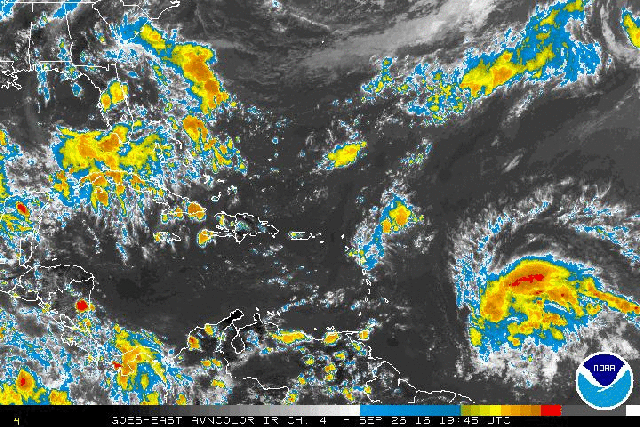
Invest 97L, an unusually strong late-season African Easterly Wave is steadily moving west-northwest over the central Atlantic Monday evening; the system has a large area of convection with notable mid-level rotation. This large size and rather persistent convection, along with a large amount of vorticity per the rotation, suggest that this system is organizing and will likely be somewhat more resilient to dry air and shear over the next couple of day. Unfortunately as of this writing there isn’t any recently updated ASCAT or microwave satellite imagery of 97L, but images from earlier Monday suggested that 97L did not yet have a closed circulation. The hurricane hunters will begin flying the system on Tuesday, which will likely give us an idea on the status of 97L’s low level circulation and whether or not it’s closed. Once the low level circulation closes, the convective organization easily supports an upgrade a tropical depression. This could occur at any time on Tuesday or Wednesday.

In the short term, water vapor imagery shows that the well-organized tropical wave is in a favorable environment for further development; upper lows well to the NW and NE of the wave are providing for upper level divergence/outflow, with a clear anti-cyclonic motion in the high clouds moving away from the system, but are far enough away that they aren’t imparting strong shear on 97L. Although there is some mid-level dry air evident around the system, the lack of strong shear and overall large size of the moisture pouch associated with 97L suggest that this dry air won’t be a significant detriment to development over the near future.

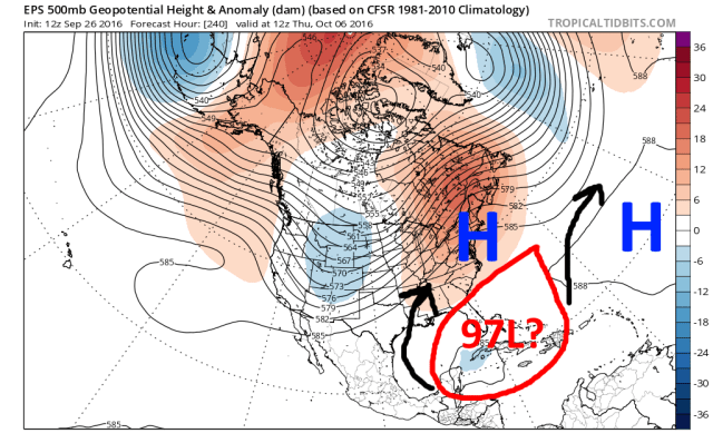
Invest 97L is currently south of a break in the sub-tropical ridging; this break in the ridging may impart a slightly more “right” component of motion on the system over the next day, which would take it WNW instead of due west. However, the tropical wave still hasn’t separated from the Inter-Tropical Convergence Zone and isn’t well enough developed to recurve through the break in the ridging, so as 97L gets to the eastern Caribbean it will likely take a slight bend to the “left” or more due west as it moves south of stronger sub-tropical ridging off of the Southeast coast. This path will take it towards the Windward Islands, and perhaps relatively close to the northern South America coast or at the very least some of the southern Caribbean islands by Wednesday-Thursday.

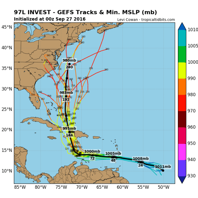
The models are in good agreement in the upper level anti-cyclone remaining co-located with 97L through mid-week as it tracks towards the Windward Islands. Given 97L’s current presentation, there’s a very high likelihood that this continued favorable environment allows for it to become a classified tropical storm by the time it gets to the Windward Islands; if it somehow hasn’t closed off its low level center by Wednesday, it would still produce squally conditions on the islands.
As the system moves west of the Windward Islands, it will move into a historically hostile area for tropical cyclones between South America and the Greater Antilles. There are signs that conditions in this region may be less than stellar as 97L moves through:

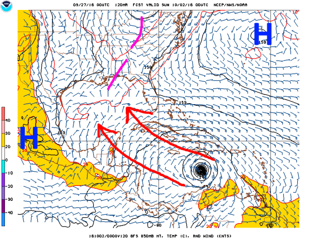
The first main issue is that 97L will be tracking rather far south and have a larger circulation than normal. Northern South America is actually fairly mountainous, and downslope off of those mountains will likely cause dry air to choke off the moist southerly inflow into the system Thursday-Friday as it passes close to northern South America. It’s worth noting that the GFS, pictured above, is farther north than recent runs of the Euro and still has a dry low level flow into the likely tropical storm later this week as it passes close to northern South America. This may slow down 97L’s intensification for a couple of days.

In addition, 97L will get caught up in somewhat stronger trade winds over the eastern Caribbean; this has in the past caused the low-level circulation in developing systems to try to outrun the mid-level circulation, resulting in a decoupled storm and effective westerly shear. How much 97L can intensify in the next two days may determine if it holds its own over the eastern Caribbean, or perhaps levels off for a couple of days or maybe even weakens a bit.
The intensity of 97L in the Friday-Sunday time-frame over the eastern Caribbean will likely have significant ramifications on its motion through the weekend, which has obvious impacts on the track forecast heading into next week, due to the low-level sub-tropical ridging being stronger to the north of 97L than the upper level ridging:
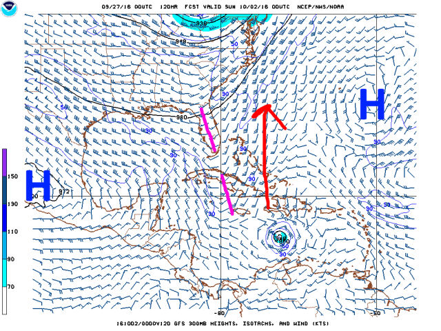

An upper level trough over the eastern US will cause a weakness to develop in the sub-tropical ridging to the north of 97L this weekend into early next week; this weakness is more pronounced as you head farther up in the atmosphere. A weaker storm will be carried by the lower level flow and likely maintain a more brisk WNW motion through the weekend, while a stronger storm (probably would need to be a hurricane) would likely slow significantly and turn due north over the weekend. This likely means the difference between a storm that accelerates towards Hispaniola on Sunday and a storm that is tracking south of Jamaica, and right now we have reliable models showing both extremes consistently. Unfortunately, the pattern doesn’t remain static between days 5 and 10, so when exactly the storm tries hooking north (if ever) has major implications down the road.
This may be a rare instance where the longer term intensity forecast is somewhat more certain than the track forecast; although how the system manages to hold up in the eastern Caribbean is questionable, once the system tracks a bit farther west/northwest, the environment appears conducive for significant intensification:

Assuming 97L continues to fire a reasonable amount of convection, it should remain coupled with its upper level anti-cyclone, as there won’t be an upper troughs or lows in the immediate path of the storm. This would allow for 97L to remain in a low shear and strong outflow environment for the foreseeable future. The last several GFS and Euro runs show this. Not only will shear be low, but mid-level RH values are expected to remain high with 97L, so once the circulation starts pulling away from South America dry air should not be an issue:

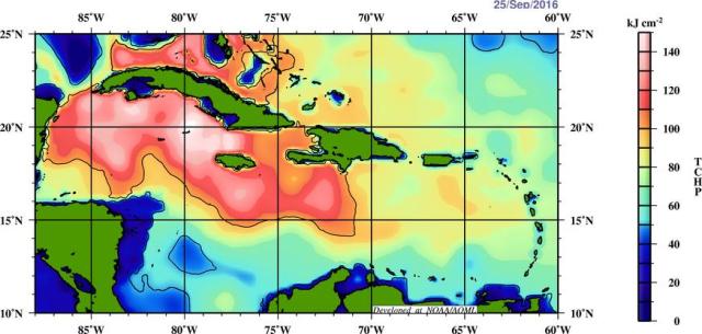
The favorable shear and moisture will be accompanied by explosively warm waters in the Caribbean, with these warm waters extending to great depths:
This combination of factors means that once 97L pulls away from South America a little bit, there is a very good chance it intensifies into a hurricane…and barring a quick north turn into Hispaniola, there’s a good shot it becomes a major hurricane. Even if the storm turns north towards Hispaniola quickly, it may have a couple of days to really get its act together.

As we head farther out into early next week, the eastern US trough is expected to be replaced by a ridge, with the upper level trough shown on the GFS over the Gulf this weekend slowly moving west. This will allow the weakness in the sub-tropical ridging over the western Atlantic to weaken early next week. Where 97L is when this happens has large implications on the track through the rest of next week. Does it recurve early, move over Hispaniola and stay far enough east to leave everyone except Bermuda alone when the ridging starts to build back it? Does it keep chugging WNW through the Caribbean and then turn towards the Yucatan or Gulf as it rounds the expanding Atlantic sub-tropical ridging? Or does it recurve somewhere in between and drift north around the Bahamas, Florida, or Southeast Coast? It is too early to tell, but there’s a huge range of solutions; some of them threaten more land than other.
By the middle of next week, the ensembles still show an anomalous ridge over the eastern US, which means any tropical system underneath the ridge may not recurve out to sea. But again, the position of 97L at this point is very uncertain, so whether the system is threatening the Yucatan or the US, somewhere, or is out to sea by this point is uncertain. It is concerning that the GFS and Euro ensembles both have a blocky weather pattern with an intensifying ridge over the US in this timeframe; if the system doesn’t escape early, it could stick around for a while in the general vicinity of land.
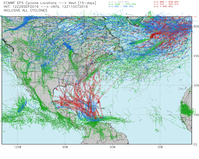
The ensemble members of the GFS and Euro models show this unusually large uncertainty in the track over the weekend and into next week:
The GFS ensembles all agree on a sharp turn north towards Hispaniola, with general agreement on a slow movement farther north. There are solutions ranging from recurve out to sea to Florida landfall in there. The Euro ensembles are even more dispersive; normally I can’t post Euro ensemble images, but this was posted on Twitter by Ryan Maue, so in the interest of enhancing this post I’m going to use it:
If you want to see that graphic whenever you want, get a WeatherBell subscription.
The Euro ensembles do have some members that have an earlier hook north and farther east track, but many more track the storm closer to northern South America, intensify a bit slower, and either turn it north later, implying a greater track to Florida or the eastern Gulf, or trap it under the re-building ridging completely and take the storm into Mexico.
So, at this point, uncertainty after Friday or Saturday is very high. Here is a summary of what we know/what to look for:
-97L will likely become a tropical storm before affecting the Windward Islands on Wednesday. 97L will then threaten the southern Caribbean Islands and/or northern South America as a tropical storm Wednesday-Friday.
-97L may see its development arrested somewhat by proximity to South America (dry air) and unfavorably strong easterly low level winds (trade winds) Wednesday through Friday.
-Regardless of how slow development is through Friday, all signs point towards significant intensification over the Caribbean once it moves northwest a bit away from South America and also away from the stronger trade winds.
-How quickly this storm intensifies will determine its medium range track; I believe the storm will intensify quick enough to get a pull north, but may not turn right as quickly as the GFS suite insists on. I can see a slow track towards Jamaica or Cuba as being favored somewhat over other possible solutions.
-Regardless of which Caribbean land masses 97L eventually impacts, there is an increased risk that it does so as a significant hurricane, meaning all of the northern and western Caribbean islands need to watch this storm closely.
-Where the storm is in 7-8 days, which is very uncertain, will impact where it tracks when ridging builds back over the eastern US. There is admittedly a potential US threat with this system, but a recurve east of the US is still a plausible solution, as is a track into the Yucatan…I currently am leaning against the farthest south solutions due to the likelihood of this strengthening and then drifting north into the weakness in ridging before it closes, but I can’t ignore the significant cluster of Euro ensemble members that take the storm into Mexico.
-Once we get a better handle on how this behaves in the eastern Caribbean later this week, we will have a better shot at nailing down the long term track of this storm.
-There may be a significant threat to Hispaniola, Puerto Rico, Jamaica, and/or Cuba within the next 5-7 days. The future threat to the US, Mexico, and/or the Bahamas is too uncertain to really discuss right now, but it is worth watching.
