

Tuesday ended up being a very active weather day across portions of Ohio, with reports of thunderstorm wind damage (blue W) and large hail (green H) scattered across the state on the map above. Not included on this map are also several areas that saw flash flooding due to slow moving thunderstorms with heavy rain. Unfortunately, there will likely be a few more rounds of stormy weather through the weekend.
WEDNESDAY:

As pictured above, the Storm Prediction Center has placed all of Ohio in at least a “marginal risk” (risk level 1/5) for severe weather for Wednesday and Wednesday night, with a “slight risk” (risk level 2/5) currently grazing the northwest corner of the state.
The setup for Wednesday will be somewhat similar to Tuesday, with a very moisture-rich airmass in place, with any amount of sunshine producing moderate amounts of instability (thunderstorm fuel). The combination of this adequate fuel for thunderstorms, combined with a warm front lifting from central Ohio into northern Ohio during the afternoon and evening while a weak upper-atmosphere “disturbance” moves in from the west by early-evening will likely allow scattered thunderstorms to break out Wednesday afternoon across western Ohio that spread east/northeast towards early evening. This may be a situation where multiple clusters of thunderstorms try to break out through the day, perhaps starting early in the day in southern Ohio (again) and shifting farther north/east with time.
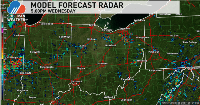
Our models are in reasonable agreement in developing at least scattered storms by Wednesday afternoon that gradually shift north/east by early-evening, with the potential for additional storms to develop and move in from the west through the evening. Anyone south of roughly route 30 will have a risk for a storm pretty much any time, with chances north of route 30 not increasing until later in the afternoon. Locations near Lake Erie may stay dry until early-evening.
Much like Tuesday, winds in the atmosphere will be fairly weak, suggesting we’ll see slow-moving thunderstorms that don’t produce widespread or long-lasting severe weather. Instead, the risks will be locally heavy rain with a risk for flash flooding, locally damaging winds, and perhaps some brief hail with the strongest of the storms.

The risk for storms may persist through Wednesday night, as another (more potent) upper-atmosphere disturbance approaches from the west and as we stay humid. The best risk for storms moving in from the west will be late in western Ohio; storms should diminish overnight farther east, but with so much moisture in the air an isolated storm can’t be ruled out overnight farther east. The severe threat Wednesday night should be quite low (any risk would be with any storms moving in from the west if they’re organized), but some locally heavy rain could still occur.
THURSDAY:

Thursday will feature a continuation of our warm and very humid conditions, while a more potent disturbance moves through the region. This will likely cause scattered to numerous thunderstorms to develop by Thursday afternoon, with a risk for at least a few of these storms to turn severe. The Storm Prediction Center currently has all of Ohio under a “marginal risk” (risk level 1/5) for severe weather for Thursday into Thursday evening, and that has a chance to be upgraded as we get closer.

The potential will exist for multiple areas of storms in or near Ohio Thursday afternoon and evening. Winds aloft will be stronger than Tuesday or Wednesday, so the risk for severe weather may be higher. The main risks will be damaging wind and large hail, though some local flash flooding due to heavy rain and perhaps a brief tornado also can’t be ruled out depending on how things play out.
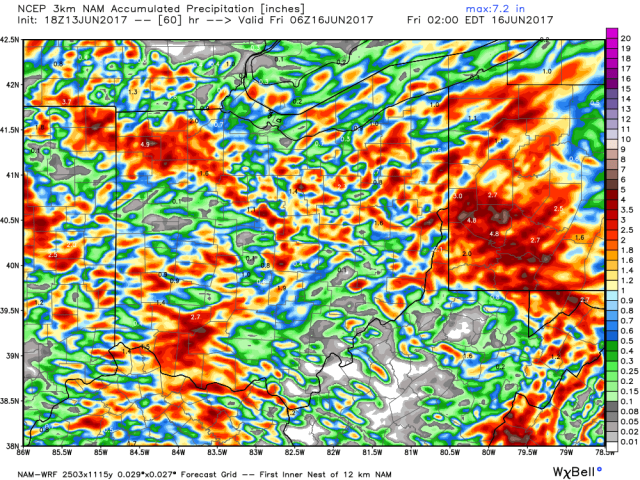
As this model image (through Thursday evening) shows, not quite everyone may get blasted over the next couple of days, but some areas will. Areas that see storms may see quite a bit of rain, along with some risk for severe weather.
FRIDAY & WEEKEND:
Friday should find Ohio between systems with just a few isolated showers/storms (rain chances only around 20% on average). A stronger low pressure will track through the Great Lakes this weekend, pushing a cold front through on Sunday. This will likely bring a return to storm chances this weekend, especially late Saturday through Sunday. Some of these storms may also be severe…plenty of time to watch for that.
