

Hurricane Irma is churning away in the eastern Tropical Atlantic as a powerful category 3 hurricane. The hurricane is currently on a westerly heading at 13MPH. It is well over 2000 miles away from Florida, meaning it will take quite a while to get into the western Atlantic.
Key Points:
- Irma is a major hurricane and will remain a very powerful hurricane through all of next week, and potentially beyond. There is the distinct potential for Irma to be a category 4 and potentially at times a category 5 hurricane as it passes near or north of the Lesser Antilles and then towards the Bahamas.
- The first threat to land will be the Leeward Islands and Puerto Rico around Wednesday and Thursday. Irma may pass just north, but that is not yet certain and interests there need to closely monitor Irma.
- Irma will get into the western Atlantic late next week, which will put the Bahamas, Bermuda, and the US East Coast from Florida points north on alert. The realm of possible tracks extends from the eastern Gulf of Mexico or Florida to just east of Bermuda. This is a HUGE amount of spread and is primarily a function of the distance out in time the threat from Irma would be, but illustrates that while a lot of areas need to monitor the progress of Irma that it’s too early to sound any alarms for any area.
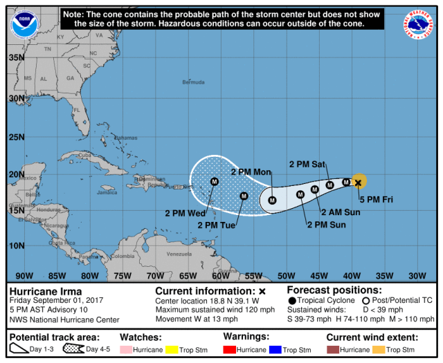
Much has been made about Irma potentially threating the US East Coast in about 10 days. Above is the National Hurricane Center forecast. It only goes out five days, and note that the only land reasonably threatened in that timeframe is the Leeward Islands and possibly Puerto Rico. The hurricane will start turning northwest by the time it gets that far west, but a very unusual west-southwest motion over the weekend will put Irma reasonably close to those islands. Note that the NHC forecast ends well before getting to the US East Coast, because uncertainty beyond five days is very high. Don’t worry, we’ll look at where Irma may go when it gets farther west in just a minute, but that perspective is important.

First, it looks like Irma will be a powerful hurricane for a long time. It is already a “major hurricane,” and as can be seen by the map of oceanic heat content above is going to be moving over considerably warmer water as it heads farther west. In addition, Irma is already in a fairly low wind shear environment, and the upper level winds are also expected to become even more conducive by the middle of next week:
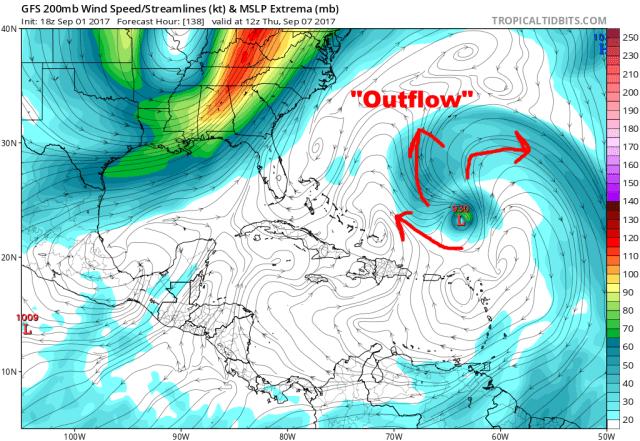
Our forecast models are in good agreement in consistently showing Irma interacting with a weakening upper level low to its north/west next week. This upper low may aid in allowing upper-level winds to fan out from the hurricane, which is an important factor to most upper end (category 4/5) storms. The combination of the expected favorable upper-level winds and high-heat-content water will likely allow Irma to maintain major hurricane intensity for the foreseeable future (through all of next week, at least). It is likely that Irma will become a category 4 hurricane next week and potentially remain as such for a number of days. Category 5 hurricanes are rare, and it’s hard to pin down well in advance what storms will perfectly come together as such, but Irma is a candidate to potentially become a category 5 during the second half of next week or into next weekend, especially if it stays north of the Greater Antilles as expected.

As for where Irma will go later next week as it churns farther west, and closer to the Bahamas and US, there are two key players that are readily identifiable on the above forecast model ensemble projection for Thursday morning:
- A large ridge centered over the central Atlantic; this anomalously strong ridge will be responsible for Irma’s unusual west-southwest motion this weekend.
- A fairly deep trough over the eastern US; this trough will attempt to weaken the ridge over the western Atlantic, allowing Irma to turn more to the north next week. How deep this trough is, and how long it lingers, will ultimately determine if Irma can turn north quickly enough to avoid the Bahamas and US East Coast or if the ridging is able to extend back west and steer the storm into land.
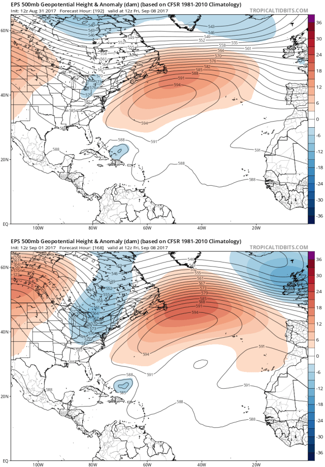
If nothing else changed in the above image, the trough over the eastern US would curve Irma just to the east of the US, but it would kick it away without major impacts. Unfortunately, weather patterns are not static, and here’s the projected upper-level weather pattern from the same ensemble (the European ensemble) for just two days later:

The trough over the east, on this ensemble mean, is quickly pulling out, potentially giving an opportunity for the ridging to extend farther west and blocking Irma’s escape. If nothing changed from here, Irma would pass extremely close to or hit Florida, Georgia, or the Carolinas. Another ensemble of models (the GFS ensemble), valid at the same time, shows the trough located a bit farther west:

This would also potentially allow the ridging to extend far enough west to push Irma dangerously close to or into the Southeast, although it’s close, and may leave just enough room for the hurricane to miss just to the east. Here’s the next run of the GFS ensemble from this evening:

Well, that’s different, with the trough located much farther west. This look would certainly bring Irma into the Southeast. It’s just one run of our second best performing ensemble, and is a bit of a blip compared to previous runs, but shows the uncertainty and how sensitive the future track of Irma is to relatively minute changes in the large scale pattern nearly eight days out. The reason for the frequent changes in the depicted pattern ahead of Irma is a typhoon over the western Pacific:

This projection for Sunday afternoon shows the Typhoon moving into the jet stream over the northern Pacific. This adds a shot of energy to the jet stream and ultimately is responsible for the trough over the eastern US later next week. How this typhoon interacts with the jet, which is hard to model well, will not be resolved until about Monday, so forecasts before then are rather uncertain. Here is the amount of uncertainty we’re looking at:

The above plot is a look at all 51 members of the European ensembles and where they take Irma over the next 10 days. There is a spread from west of Florida to just east of Bermuda in 10 days among the ensembles. Due to the factors causing the uncertainty (the typhoon over the Pacific, where exactly Irma tracks over the next 5-7 days, and in general just time), it’s too early to tell you if:
- Irma will hit land
- Where Irma may threaten if it did hit
There IS fairly good agreement that the trough will weaken the ridging enough for a tug north next week, which should keep Irma from getting much farther west than Florida. This is good news for places like Texas and Louisiana that are still reeling from Hurricane Harvey’s impacts. The Bahamas certainly need to watch Irma closely, as Irma should be a very powerful hurricane in that area, and as even if the storm just missed the US East Coast it could still track through parts of the island chain. Other than that, the European ensemble has roughly 20-30% of its members actually hit the US East Coast between Florida and New England (most that hit do it over the Southeast).
The GFS ensembles have gradually been trending farther southwest with Irma’s track over the last several runs. The GFS ensembles initially were all in pretty good agreement on a recurve east of the US, but have generally trended closer to the US and have more members hitting the US in the most recent run. The reason for this trend is evident when looking at the trend map for the GFS ensemble upper level pattern:

The GFS ensemble, in general, has been shifting the trough and ridge west over its last 8 runs, forcing Irma closer to the US coast. Blue colors represent lower heights (corresponding to more troughing or less ridging), with red colors indicating the opposite. The European ensemble, when comparing its Thursday afternoon run to its Friday afternoon run, has shown the opposite trend!
Thursday’s run is on top, Friday’s on the bottom. Note how there’s more blue over the eastern US on Friday’s run, indicating a deeper trough centered farther east. Irma is also a bit slower in today’s run, which may also have an impact on the future track of the hurricane. Are you dizzy yet?
The bottom line is, the ridging over the Atlantic will steer Irma towards the western Atlantic over the next week. Irma will pass awfully close to the northern Lesser Antilles, the Virgin Islands, and Puerto Rico around Wednesday and Thursday, and interests on those islands need to closely watch Irma. The Bahamas may be at risk, especially if the ridging is on the strong side. There clearly is the potential for an impact, either directly or indirectly, along the US East Coast, however, there is considerable uncertainty in the exact interaction between Atlantic ridging, eastern US troughing, and Irma, and a track east and away from the US is still also a distinct possibility. Anyone along the East Coast from Florida points north should monitor Irma, but at this point no one area is at a particularly large risk for a direct impact. I personally am more concerned about Southeast and southern Mid Atlantic than the Northeast and New England, but no one area can be ruled out or singled out yet, or for a number of days.
We’re at the “keep an eye on it” stage, not the “plan for impacts” stage. Clarity should increase next week once the Pacific typhoon situation resolves itself, and once we know Irma’s exact track over the next few days.
