
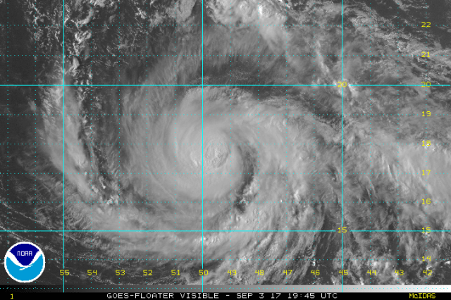
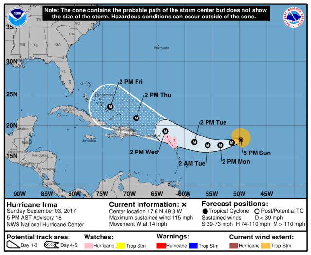
Hurricane Irma has been fluctuating in intensity over the last couple of days between a strong category 2 and low category 3 hurricane, as the hurricane has turned towards the west-southwest over the open Tropical Atlantic. Irma is a small storm for now, but the size and intensity of the storm are both expected to go up over the next few days. Here is the latest official forecast (as of 5:00PM EDT Sunday) from the National Hurricane Center for Irma:
Take Home Messages:
- Irma is a major hurricane and will likely pass dangerously close to or over the northern Leeward Islands, Virgin Islands, and Puerto Rico between Tuesday night and Wednesday night. Hurricane watches have now been issued for parts of the Leeward Islands, and additonal watches and warnings are likely to be issued by Monday. Irma is expected to bring dangerous conditions to these islands, and a direct impact from a major hurricane is possible in these areas. Preparations to protect life and property in these northern Caribbean Islands should be underway now. Continue to monitor the National Hurricane Center and your local weather office, and follow instructions from local government officials to protect your life and property in the northern Leeward Islands, the Virgin Islands, and Puerto Rico.
- Impacts are looking increasingly likely for Haiti and the Dominican Republic. The current forecast takes Irma just north of Hispaniola, but at least indirect impacts are forecast. A direct landfall is still within the margin for error for Hispaniola.
- The forecast is looking increasingly dire for the Bahamas. The official National Hurricane Center forecast has Irma very near the Turks and Caicos Islands at the end of the week as a very dangerous category 4 hurricane. Although not yet within the 5-day forecast, direct or indirect impacts from Irma as a very powerful hurricane are expected for the rest of the island chain. Preparations to protect life and property in the Bahamas should be underway now or soon. Continue to monitor official forecasts, and follow advice and any evacuation orders from local officials over the next several days. Barring a direct impact on Hispaniola, which would weaken Irma, Irma is expected to be an extremely dangerous major hurricane (likely a category 4 and potentially a category 5) as it moves near or over the Bahamas.
- Persons located along the US East Coast from the northeastern Gulf Coast east to Florida and points north to the Southeast, Mid Atlantic, and Northeast need to be prepared to put their hurricane plans into place this week, as there remains a credible threat for a landfall somewhere along the US coastline. Florida and the Southeast may be at highest risk, though no one can be ruled out or really singled out yet. With that said, forecast errors in the 6-8 day timeframe, which is when the potential landfall would occur, are often very large, so it is still much too early to pinpoint if landfall will occur or where it will occur. Irma curving just east of the US coastline and going out to sea is still a viable solution at this time, though the odds of that outcome have decreased some over the last day.
- Another reason not to focus on potential exact landfall points this far out is that Irma is expected to be a large and powerful storm as it approaches the US. Impacts, if a landfall were to occur, would occur well away from the center. Even a close miss would have some indirect impacts.
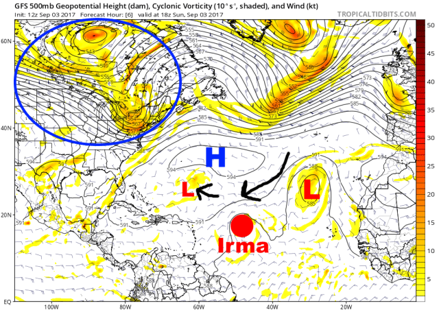
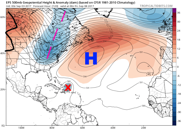
Above is a look at the upper-level pattern over the Atlantic and US that will steer Irma over the coming days. The features here have not changed over the last couple of days. A strong ridge of high pressure over the sub-tropical Atlantic is steering Irma west, and will generally continue to do so for the next few days. An upper low, northeast of Irma, is imparting a bit of southerly motion, resulting in a net west-southwest motion at the moment and for the next couple of days. A small upper low northwest of Irma will likely give Irma a slight northerly tug by Tuesday and Wednesday, allowing a west-northwest motion to resume as it approaches the Leeward Islands Tuesday night into Wednesday. The big blue circle over the US represents an area where a trough, or dip, in the jet stream will develop this week, trying to eat away at the ridge over the western Atlantic. How much this trough lingers, and if the ridge can build back in as Irma approaches, will be key to Irma’s track near or over the Bahamas and near and potentially into the US.
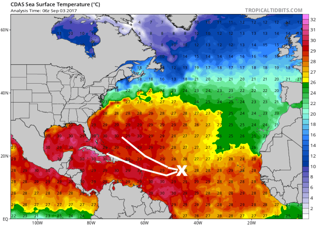
Regardless of exact track, the oceanic and environmental conditions support Irma remaining a strong hurricane and likely intensifying over the next few days. Irma has recently begun moving over warmer sea surface temperatures, and the waters stay as warm or perhaps warm further in its expected path. The only possible significant impediment is a close brush with the mountainous Hispaniola if Irma ends up on the southern edge of the current forecast track.

In addition to warm water, the upper-level winds are expected to become very favorable for a strong hurricane during the second half of the week and into the weekend. An interaction with the aforementioned upper-level low currently to the northwest of Irma and a trough and associated stronger jet stream over the eastern US is expected to allow winds at the top part of the troposphere to really fan away from Irma. This would allow Irma to become a very powerful hurricane and remain as such for several days, barring any land interaction with Hispaniola. This intensity forecast is again cause for significant concern for the northern Leeward Islands, Virgin Islands, Puerto Rico, potentially Hispaniola, and the Bahamas over the next several days.
As for the track forecast, here’s a look at the modelled upper-level pattern for Thursday evening from the European ensemble. Irma has reached the southwestern edge of the large sub-tropical ridge across the Atlantic, which would likely allow a WNW or NW motion into or dangerously near the Bahamas. There’s a deep trough over the eastern US, which is eating away at the western edge of the Atlantic ridge and trying to give Irma a route out to sea and just east of the US. In addition, there’s a ridge over the western US quickly building east and trying to push the trough to the east, which if it occurred would block Irma’s escape.
Here’s the pattern 24 hours later from the same ensemble. Irma is moving WNW or NW over the Bahamas and slowing as it approaches the weakness in the ridge left by the trough. At this point, there is still an escape route out to sea east of the US (though it’s a worse picture for the Bahamas), but the trough is moving quickly east as the ridge from the west surges to the east. At this point, if Irma is moving fast enough it probably hits the weakness, if it’s slow enough or far enough south it may miss it and get trapped, resulting in a US landfall.
This afternoon, the “deterministic” runs of our two main global forecast models had differences in how the ridges, trough, and Irma all interact, resulting in drastically different outcomes for the hurricane:
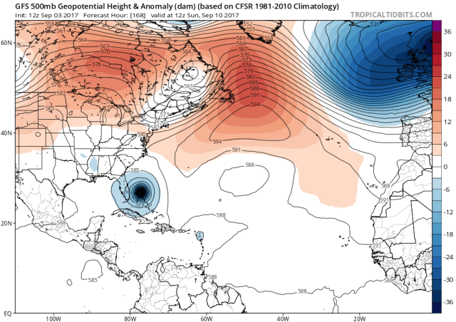
The GFS plowed Irma into the Carolinas as a powerful hurricane. Its forecast for Sunday morning shows the trough quickly moving northeast (note how there’s no blue coloring left over the northeast US), with ridging beginning to bridge the gap north of the hurricane (note how red coloring is beginning to develop north of Irma). There’s also a subtle upper low over the lower Mississippi Valley, which if it verified could give Irma a very small tug to the west as well.
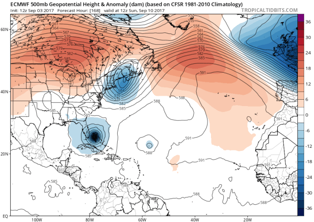
The European model is actually a bit slower and a tad farther southwest with Irma over the Bahamas in this forecast image, valid as the same time as the GFS image above. The Euro may even be more aggressive in building ridge in from the Midwest. However, the Euro drags its feet much more with the trough moving out of the northeast, which, despite other variables the forecast perhaps suggesting the hurricane tracking into the US coast actually allows Irma to recurve close to but just off the Southeast Coast. The Euro also has the small upper low northwest of Irma, but has it farther west.

The above image represents the trend among the GFS ensemble over the last two days’ worth of runs. Before this afternoon’s model runs, the trend among both the Euro and GFS ensemble was to pull the trough out faster and allow ridging to build in quicker north of Irma. Both trends would increase the likelihood for a US landfall. This afternoon’s GFS ensemble trend is similar to what the Euro did; a trough that’s slower to leave over the Northeast (the blue colors), with more aggressive ridging building in from the west over the Great Lakes (the red colors). The net trend, regardless, is for a larger opening north of Irma. So, despite the 12z GFS ensemble members almost unanimously hitting the US with Irma, there were continued trends, suggesting it’s too early to set anything in stone.
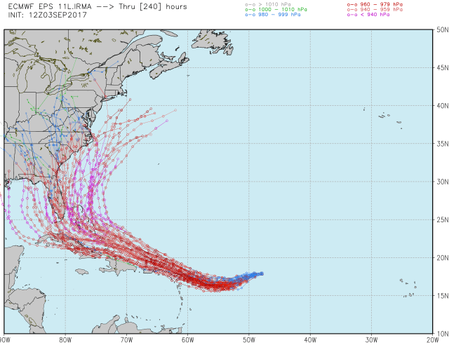
The European ensembles over the last several runs have had a majority of members fail to hit the US. This afternoon’s run is I believe the first run to show a majority of members hitting the US. However, a significant cluster (roughly 1/3 of the members) still miss the US just to the east, as does the operational model. This is only ONE RUN that shows a majority of members hitting the coast, with a significant portion still missing the coast, so it’s still too early to declare landfall inevitable.
At this point, minute changes in the upper-level pattern ahead of Irma, and less importantly changes in Irma’s track itself, still will make the difference between a US hurricane landfall and Irma missing just to the east. It is still TOO EARLY to claim with any certainty whether Irma will hit and where, though there clearly is a threat, especially to the Southeast. Other areas, such as the eastern/northeastern Gulf Coast, Mid Atlantic, and Northeast, though perhaps at lesser risk, still can not be completely ruled out yet. Because of this, all interests along the US East Coast and eastern/northeastern Gulf Coast need to monitor the progress of Irma closely. With that said, we’re still probably at least a day or two from knowing with more certainty whether or not landfall will occur on US soil or not.
