
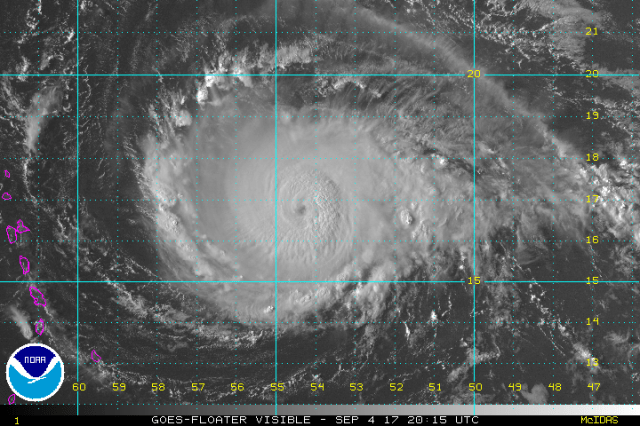
Hurricane Irma is continuing to progress at a south-of-due-west direction across the open Tropical Atlantic Monday afternoon. Irma is now a powerful category 4 hurricane, and has grown in size since Sunday. Here is a look at the National Hurricane Center forecast track as of 5AM EDT Tuesday:

Take Home Messages:
- Hurricane and Tropical Storm Warnings have been issued for the Leeward Islands, as Irma is expected to pass over or dangerously near these islands. Damaging winds, heavy rain, and storm surge are expected starting Tuesday afternoon and through Wednesday. All residents in these areas are urged to follow the advice of local officials. Preparations to protect life and property should be underway now and completed by Tuesday morning.
- Irma will pass close to (but likely just north of) the Virgin Islands and Puerto Rico, bringing dangerous conditions beginning Tuesday night and lingering into Thursday morning. Hurricane Watches are in effect, and warnings will likely be issued as Irma approaches. All residents in these areas are urged to follow the advice of local officials. Preparations to protect life and property should be underway now and completed by Tuesday night.
- Indirect impacts continue to look likely in Haiti and the Dominican Republic. Life-threatening flooding is expected to be the main hazard on Hispaniola as Irma will be a large storm passing near that mountainous terrain. A more direct impact bringing damaging winds and a dangerous storm surge is still possible if Irma follows the southern side of the track forecast.
- Irma is still expected to pass near or over parts of the Bahamas between Thursday night and Monday as a dangerous major hurricane. Although the official track forecast has been adjusted south farther, and now actually takes the hurricane closer to Cuba than parts of the Bahamas, it is important to note that the track forecast near the Bahamas is still uncertain. Irma is expected to slow and abruptly turn more to the north near the end of the week. Whether that happens farther east, allowing a track through many of the Bahamas, or farther west, potentially keeping Irma south and west of most of the Bahamas and causing a more indirect impact, is still uncertain. At least indirect impacts are likely in the Bahamas, and future track adjustments causing more severe and direct impacts are still possible. Keep a very close eye on Irma, follow the advice of local officials, and have your hurricane plan ready to potentially be put into use later this week. Again, a direct impact as a major hurricane remains a very possible outcome in the Bahamas, especially in the Turks and Caicos.
- The continued adjustment southwest in the track of Irma through the end of the week is putting the United States at increasing risk of a direct landfall from Irma. Though the threat for a landfall is increasing, especially in Florida and the Southeast, considerable uncertainty exists due to Irma’s expected turn north at the end of the week. Whether that turn occurs far enough west to hit Florida, or just east, is uncertain. This sounds cliché, but any track from the eastern Gulf Mexico to out to sea remains on the table with Irma, so the entire East Coast and northeastern Gulf Coast need to monitor Irma. With that said, one region that appears to continually be a bit more favored for a *potential* landfall remains Florida and the Southeast including Georgia and the Carolina’s. All residents in hurricane-prone areas in the United States from the eastern Gulf up the East Coast should continue to closely monitor Irma.
- Irma is now becoming a larger storm and will likely remain as such. As Irma passes near or potentially over several land masses over the next week or so, impacts will extend well away from the center of circulation. If Irma makes landfall in the US, heavy rains and gusty winds would impact a large number areas not just near the landfall point.
National Hurricane Center: http://www.nhc.noaa.gov/
US National Weather Service: http://www.weather.gov/
Great website for forecast models, airplane recon data, and more: https://www.tropicaltidbits.com/
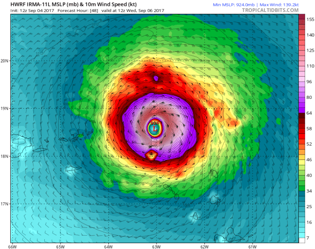
Not much has changed in the short term forecast for Irma. Irma has continued moving west-southwest over the last day, and has gradually intensified as it’s moved over warmer water, into a more moist airmass, and while dealing with only light wind shear. The hurricane has also increased in size a little bit. The above is a model image from one of our better performing regional hurricane models this season, and it shows Irma passing very close to the northern Leeward Islands Wednesday morning. Note how there’s a large area of hurricane force winds (anything purple and higher) that is impacting some islands, with Anguilla in the eyewall and experiencing potential major hurricane conditions. A small adjustment south from this modelled position (which is possible) would potentially bring hurricane and major hurricane conditions to more islands. Hence, this is a serious situation for the Leeward Islands.
From here, the storm will continue moving west-northwest, likely taking it just north of Puerto Rico and the Virgin Islands. With that said, the Virgin Islands especially may still see hurricane conditions, and any adjustment south would cause a quick deterioration in conditions for Puerto Rico and the Virgin Islands.
As we move forward, the players in Irma’s future track close to the Bahamas, Cuba, and US have remained the same, though continued small changes in the features continue to cause uncertainty in the forecast. A continued trend has been for the trough over the eastern US to dig in just a little bit less, which keeps the western portion of the Atlantic ridging (the portion extending towards Florida) a bit stronger. This has caused the continued southwestern trend in Irma’s forecast track as it gets close to the Bahamas, Cuba, and Florida. Another key piece to watch is a subtle upper-level trough diving southeast towards the Mississippi Valley, as that is expected to keep a weakness in the ridge somewhere near the Mississippi Valley as the trough in the Northeast moves out. This is expected to cause Irma to still turn north at some point near the end of the week or weekend.
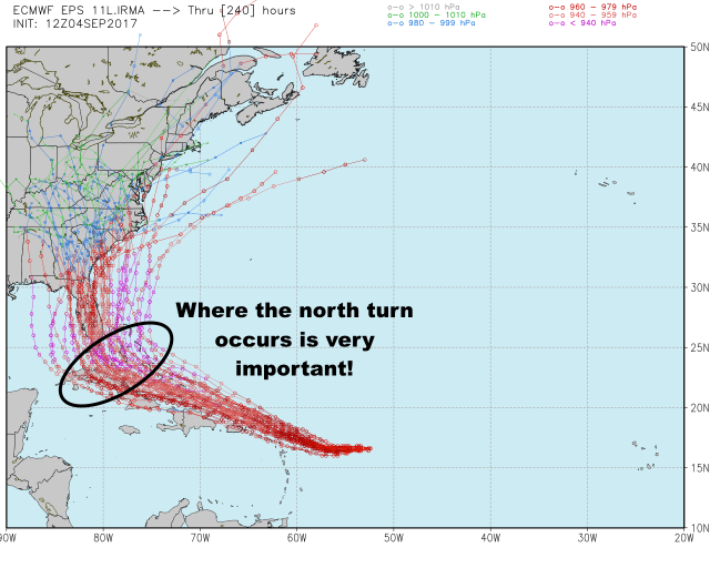
There is still spread in where Irma’s north turn occurs on Friday or Saturday, which has big ramifications on Irma’s future track and potential US landfall location. If the hurricane is on the northeastern edge of the model guidance, it would still have an opportunity to follow the weakness created by the eastern US trough and curve out to sea. If the hurricane is on the southwestern edge of the model guidance, it could go over Cuba and then turn into the eastern Gulf or Florida. A potential turn in between could threaten the east coast of Florida or the Southeast. Obviously, where this turn occurs impacts much of the Bahamas as well.

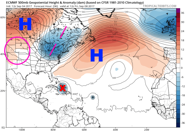
Here is a look at the pattern impacting Irma’s motion Saturday morning. Note how there IS a weakness in the ridge along the East Coast, but that due to how far south Irma is, some weak ridging is able to bridge the gap and potentially prevent Irma’s escape. Because the weakness is still there on the East Coast, I do caution to declare a landfall 100% certain to occur in the US. It’s the likely outcome at this point, but the average track error for day 5 hurricane positions is still rather large, and things trending back towards out to sea are still within the realm of possibilities. Also note the subtle area of lower heights over the Deep South, associated with the weak upper-level piece of energy that will dive in from the northwest. This will help guarantee Irma’s more northerly turn, even if the hurricane misses the Northeast trough. The reason some ensemble members hook more north-northwest into the Southeast is due to Irma’s interaction with this weak upper-level trough, which is tough to predict well in advance.
All told, odds for a US landfall have increased, and a landfall is definitely more likely than out to sea. Florida (both the eastern seaboard and Gulf Coast) and the Southeast are most at risk, though some direct or indirect impacts can’t be ruled out anywhere on the East Coast yet. With that said, predictability in some of the smaller-scale features that will impact Irma’s track is still low this far in the future, meaning it’s still a bit early to really hone in on a landfall location. It’s important to note that less than seismic changes would be needed for a trend back towards the east and perhaps out to sea, so although that outcome is now looking considerably less likely, it’s something we’ll be watching for over the next couple of days.
The oceanic and atmospheric parameters favor a powerful hurricane near or over the Bahamas and threatening Florida and the Southeast. With that said, potential land interaction with Hispaniola and Cuba would weaken Irma, potentially making the intensity forecast murkier. Odds for a significant US impact have gone up, but we still have plenty to watch for and hone over the coming days. Stay tuned!
