

Hurricane Irma has continued intensifying over the last day, and is now one of the strongest Atlantic Ocean hurricanes on record with maximum sustained winds of 185MPH. Irma remains a large hurricane, and is approaching the Leeward Islands. Devastation is likely on any islands that manage to get into the core of Irma. Here is the latest official forecast from the National Hurricane Center:

Take Home Messages:
- Irma will pass through the northern Leeward Islands and the northern Virgin Islands as a catastrophic category 5 hurricane tonight through Wednesday. All preparations to protect life and property in these areas should be completed, as conditions will be quickly going downhill this evening. Destructive winds and life-threatening flooding from storm surge and heavy rain can be expected in the northern Leeward Islands and northern Virgin Islands over the next 24 hours. Stay safe and follow the advice of local officials.
- Puerto Rico and the southern Virgin Islands will feel significant impacts as Irma goes just to the north late tonight through Wednesday night. Hurricane Warnings are in effect. Damaging winds and life-threatening flooding from storm surge and heavy rain can be expected in these areas from late tonight through Wednesday night. Preparations to protect life and property should be completed this evening as conditions will be going downhill quickly by sunrise Wednesday. Follow the advice of local officials.
- Significant impacts are expected in Haiti and the Dominican Republic are Irma passes just to the north. Life-threatening flash flooding due to Irma’s large size and the mountainous terrain is expected to be the primary hazard, though damaging winds and dangerous storm surge are also expected, especially near the northern coast of the island. Hurricane and Tropical Storm Watches and Warning are in effect. A more direct impact still can’t be ruled out. Preparations to protect life and property should be completed soon, as conditions will go downhill quickly starting late on Wednesday. Follow the advice of local officials.
- Irma will pass through the Turks and Caicos as an extremely dangerous category 4 or 5 hurricane Thursday and Friday. Hurricane watches are in effect. Preparations to protect life and property should now be underway in these islands, as destructive winds and life-threatening flooding due to storm surge and heavy rain will accompany Irma. Impacts remain likely in the Bahamas and preparations should be underway, though it’s still too early to know how Irma will track through the nation. Follow the advice of local officials as the storm approaches.
- Irma continues to threaten the Southeast, particularly Florida. Though the exact landfall region is still unknown, you should begin to put your hurricane plan in place in Florida and the Southeast in case the storm threatens your area. Again, it is too soon to know where exactly landfall may occur, and the storm missing entirely to the east with just fringe impacts still is possible, though not likely. A credible threat of a strong hurricane landfall exists in the Southeast over the weekend, especially in Florida, so you should begin to prepare for the possibility and closely monitor the forecast for Irma. Impacts may extend well away from the initial landfall location. Follow the advice of local officials and evacuate if told to do so. Even if the worst of Irma doesn’t impact your location, Irma is a very strong storm, so making preparations now is the course of least regret and may ultimately save lives wherever landfall occurs.
- In all regions that Irma ultimately impacts, the storm is expected to be very large, with impacts extending well away from the center. You should prepare for impacts, even if the center line of the forecast isn’t right over your head.
National Hurricane Center: www.nhc.noaa.gov
US National Weather Service: www.weather.gov
Useful website with forecast models and aircraft recon data: www.tropicaltidbits.com

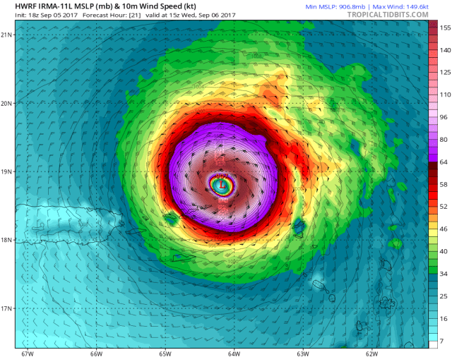
First off, this “serious” situation in the northern Leeward Islands discussed yesterday has become downright frightening, as Irma is now one of the strongest hurricanes on record for the Atlantic basin and will pass through tonight. The above image from one of our more reliable hurricane models shows Barbuda in the inner core of a category 5 hurricane tonight, getting lashed by violent winds. The core of violent winds is heading towards Anguilla and St. Martin, with damaging hurricane force winds in the purple extending farther south than that. The green represents tropical storm force winds, which will affect a number of islands tonight into Wednesday morning.
Irma is expected to continue to chug west-northwest and pass through the northern Virgin Islands on Wednesday, with the core of the destructive category 5 storm expected to impact the Virgin Islands. Puerto Rico and the southern Virgin Islands will see more of a fringe impact, but will still see adverse and potentially dangerous conditions regardless, due to Irma’s large size.

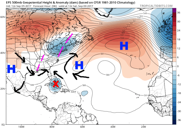
The forecast upper-level weather pattern from the American GFS forecast model valid Thursday night is pictured above. The players steering Irma over the next several days, and ultimately controlling where/if the storm hits the US, have not changed, and neither has the forecast over the next couple of days. Irma will remain on a west-northwest heading, likely staying just north of (but still bringing impacts to) Puerto Rico and Hispaniola, and then heading into the Turks and Caicos. The models have edged north just a little bit through this portion of the forecast since yesterday, but not enough to significantly change the forecast for any of these areas.
Irma will be steered in a continued west-northwest direction through the end of the week on the southwestern periphery of a sub-tropical ridge located over the central Atlantic. By the weekend, Irma will approach the western edge of the ridge, with a trough over the eastern US attempting to eat away at the western portion of the ridge. This should cause Irma to slow as it reaches these weaker steering currents by later Friday and Saturday. If the trough over the eastern US moves east quickly enough and the ridge builds back in, Irma would not have an escape route out to sea. However, another weak trough (circled over the northern Plains in the above image) dropping southeast towards the Mississippi Valley will keep a weakness in the ridge somewhere to the north of Irma…so, even if Irma misses the East Coast trough, the storm will still likely turn north but do so farther west.
Looking ahead to Saturday morning, on the European model ensemble, it’s evident why it’s still too early to declare where a US landfall will occur, as Irma will be approaching a bit of a dead zone in the steering currents. The black arrows represent some of the steering around Irma. Irma will be west of the west-northwest steering from the ridge to its northeast, it will be east of the southern steering from the ridge well to its west, but also south of the influence of the trough(s) to its north. If Irma is located even 100-200 miles farther north at this point, and the pattern shown is relatively accurate, it does have an escape out to sea. Since Irma is located a good bit farther south, it doesn’t get as much of a tug from the Northeast US trough and instead just slows down.
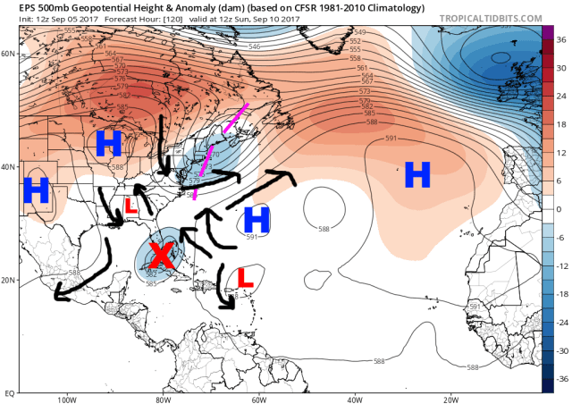
As we move the European ensemble ahead to Sunday morning, the trough and escape route out to sea are beginning to pull away from the East Coast, with Irma on the ensemble mean located near southern Florida. How far south the trough extends and where exactly Irma is located at this point is very important, as that will determine where Irma turns north and determines if Irma will go into Cuba and then maybe the Gulf, hit Florida, the Southeast, or stay just off the Southeast US coast.
If the trough is located a bit farther south, or if Irma is say located east of Orlando off the coast at this point, the escape route still hasn’t closed. If Irma is located where the ensemble mean has it, and the trough is where it is or even farther northeast, Irma hits Florida or gets into the eastern Gulf. A scenario in between is also possible. The small upper low over the Deep South will likely limit how far west Irma can get if the storm goes into the Gulf.
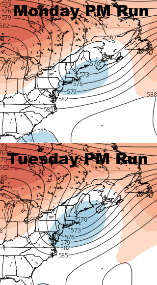
A complicating factor today is that there is some disagreement on how far south Irma goes over the next few days…for example, the GFS keeps it well north of Cuba, and the Euro takes it straight into central Cuba. In addition to that disagreement, there’s been at least a subtle trend in all guidance for the Northeast trough to move out just a little bit slower. Compare Monday afternoon’s Euro ensemble mean to Tuesday afternoon’s run…there’s just a little more blue with the trough extending farther south, meaning that on the mean the ensemble has a deeper trough in that area. That could keep the door for an escape open just a little bit longer.
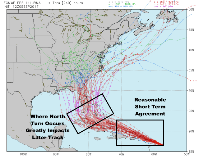
Unfortunately, today’s ensemble spread remains fairly large after about 3-4 days out. Disagreement starts north of Hispaniola, with big disagreement over where Irma’s north turn occurs. The location of this turn is influenced by Irma’s short term track and how long the trough takes to exit the Northeast. Because of this, it’s still too early to nail down exact impacts in the Bahamas, and also to determine a possible US landfall location. Note how nearly 20% of the members actually do miss the US altogether.
I expect forecast clarity to really increase Wednesday, as Irma will be tracking north of Puerto Rico at that point, which should reduce the spread that begins near Hispaniola. In addition, the models will have another day to try to work out the pattern north of the hurricane.
Unless significant interaction occurs with Hispaniola or Cuba, Irma will remain a powerful category 4 or 5 hurricane into the weekend. Fluctuations in intensity will occur due to the inner dynamics of the hurricane, but the environment remains very favorable through at least Saturday. There may be some increase in shear by Sunday.
Florida should begin to think about preparations for Irma as they are still squarely in the possible track of the hurricane, but the uncertainty is still too high to say that landfall will definitely occur there. Either coast of Florida could be hit, and the hurricane will be large and spread impacts far away from the center. There is still some potential for a track into the Gulf (though I personally am leaning against that), as well as towards the Southeast (I could see that). An out to sea scenario is still possible due to the reasons discussed above, though that is a less likely outcome. Stay tuned for more!
