
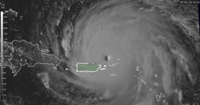
Hurricane Irma remains an extremely impressive storm, with a large and distinct eye surrounded by a very intense and complete eyewall. Irma is a very large storm, and has already done extensive damage in the Leeward Islands and Virgin Islands. Irma has maintained incredible 185MPH sustained winds for over 24 hours now, and isn’t showing signs of weakening soon. Here is the latest forecast from the National Hurricane Center:

Take Home Messages:
- Irma has battered the northern Leeward Islands and northern Virgin Islands with category 5 hurricane conditions, and is bringing inclement weather including damaging winds, flooding rain, and storm surge to Puerto Rico and the southern Virgin Islands now. Remain in a safe place in these areas until the weather improves tonight into Thursday.
- Although the center of Irma will likely stay north of Haiti and the Dominican Republic, impacts are still likely. Flooding from heavy rain in the mountainous terrain will be the main risk with Irma in Hispaniola, though damaging winds and a dangerous storm surge are also possible, especially near the northern coast. Follow the advice of local officials and stay safe.
- Irma’s next direct impact is expected to be in the Turks and Caicos as a large and extremely dangerous category 4 or 5 hurricane. Hurricane Warnings are in effect, and preparations need to be rushed to completion today. Destructive winds, significant storm surge, and flooding from heavy rain can be expected in parts of the Turks and Caicos. The southeastern Bahamas will also be dangerously close to or perhaps within the core of the hurricane on Friday. Follow any advice from local officials and stay in a safe place while the hurricane passes.
- The threat level for the rest of the Bahamas and Florida will ultimately depend on where Irma makes its much anticipated turn north on Saturday. It is too early to pin down where exactly that occurs, though many of our models continue to target Florida. Preparations should continue in all of the Bahamas and the Florida Peninsula, as further track adjustments can be expected, meaning it’s too soon to say for sure which areas will see severe impacts and which areas will not. Regardless, Irma remains a threat to these areas and you should follow the advice of local officials, and evacuate if ordered to do so.
- Irma may stay on a northward heading for a prolonged period of time, which would put the Southeast at risk if the turn occurs just southeast of Florida, allowing for a track near or just off of the east coast of Florida. Because of this, Georgia and the Carolinas, especially South Carolina, need to closely monitor the progress of Irma. Make sure you have a hurricane plan in place that can be executed within the next couple of days if Irma looks to impact the Southeast. There is still a small but non-negligible chance that Irma stays just east of the US coastline and curves out to sea. The odds of that occurring are continuing to slowly decrease.
- Irma will be a very large and powerful storm, meaning impacts will occur well away from the center. If Irma makes landfall in the US, significant inland impacts from flooding, tornadoes, and perhaps an inland damaging wind threat would be likely. The impacts could extend well inland, and potentially into regions well away from the initial landfall point such as the Mid Atlantic and Appalachians. Because of this, and the potential large track forecast error for a hurricane 4-5 days out, it is important not to focus on the center line of the forecast.
National Hurricane Center: www.nhc.noaa.gov
US National Weather Service: www.weather.gov
Very useful website, including model data and airplane recon data: www.tropicaltidbits.com

For the first time in Irma’s life we have a National Weather Service radar within range of the storm, and as expected it has revealed a very impressive storm structure. Irma’s eyewall is very intense and completely closed, which is to be expected with a category 5 hurricane. Thus far, Irma has maintained its extreme intensity for over 24 hours with no eyewall replacement cycle to cause at least temporary weakening. There are some signs on radar that the inner rain bands may be attempting to consolidate into an outer eyewall, which would trigger an eyewall cycle, though at this time it’s not imminent. This means that in the short term there won’t be a weakening of Irma due to inner core dynamics, though it could happen later tonight or Thursday. Other than inner core dynamics, let’s look at the waters that lay ahead of Irma:

That’s right, they only get warmer as Irma heads towards the Turks and Caicos and the vicinity of northern Cuba or southern Florida. In addition, mid-level dry air is expected to stay well away from the hurricane for the next few days:

Irma’s very large moisture pouch and a lack of substantial wind shear should make sure dry air intrusions into Irma are kept to a minimum. All of this, combined with continued favorable upper-level winds (in part due to the storms large size and intensity causing a positive feedback with good upper-level exhaust) will allow Irma to remain a powerful category 4 or 5 hurricane into the weekend. The only potential impediment is interaction with Cuba, which remains a possibility.
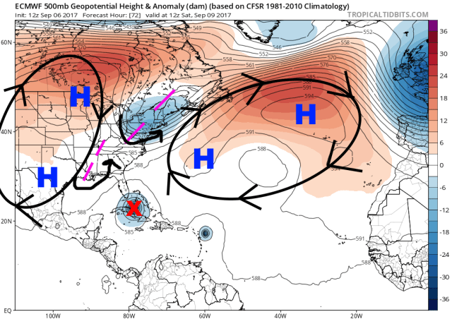
As for where Irma will go, the track forecast philosophy hasn’t changed much. Irma will continue on a west-northwest heading through the end of the west on the periphery of sub-tropical ridging across the central Atlantic. The storm may even get a brief nudge closer to due west by the ridging Friday into Saturday, taking it very close to Cuba.
By the weekend, pictured above being Saturday morning, Irma reaches a large weakness in the ridging caused by two troughs; one over the Northeast, one over the Mississippi Valley. This will cause Irma to slow and turn rather abruptly more to the north on Saturday and Sunday. As has been stressed over the last couple of days, where this turn occurs is VERY IMPORTANT for both the Bahamas and the Southeast US, especially Florida. The location of the turn and sharpness of it will be driven by both the size of the weakness, a function of the troughing north of the hurricane, and the location of the hurricane itself, a function mainly of the hurricane’s track through the end of the week.
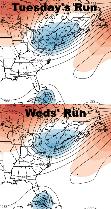
When looking at the European ensemble mean pattern, and comparing it to yesterday’s run valid at the same time (Saturday morning), it appears that today’s run has just a little bit less of a trough over the Northeast, and perhaps a bit more ridging over the Atlantic. The difference is very small. Something important that has consistently happened though is Irma has stayed on the southern side of the track guidance over the last several days. The longer this occurs, the less likely a sharper turn to the north and track out to sea is, especially since the trough in the Northeast today isn’t trending stronger or farther south.
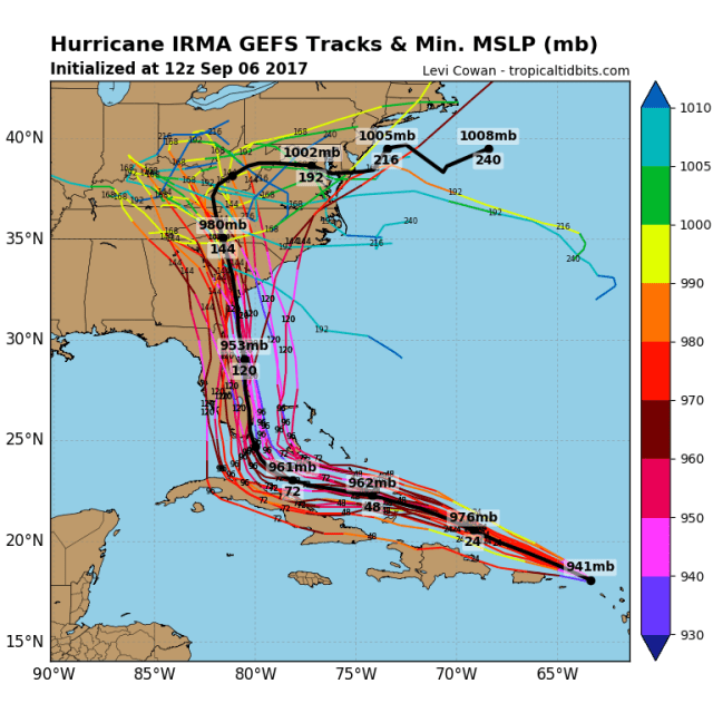
Above is a look at the GFS (American model) ensemble forecast tracks for Irma on its run from early Wednesday afternoon. This ensemble can be under-dispersive, as in the actual outcome is outside of its range of solutions; with that said, you can see how where the turn occurs is very important. A difference of 50 miles (which is small when talking about hurricane location 4 days out) may mean the difference between a hit on western Florida, Miami, or staying just east of Florida. It should be noted that the GFS ensemble last night were farther east, and this run has drifted back west.

The European model ensemble tracks have a little bit more spread, though they perhaps focus on an area a bit farther west than the GFS ensemble. Last night, more members missed Florida to the east, so although not as drastic of a shift as the GFS, the European ensemble has also shifted a bit west today. For the first time out of any runs on Irma, no ensemble member completely misses the US; the farther east member still hits the Outer Banks.
Note how some of the GFS and European ensemble members have a little bend to the “left” or NNW over Florida or near Georgia; this is due to the second, weak trough over the Mississippi Valley. This trough may initially cause an initial bend to the NNE when Irma is south of the trough, and then a small bend back to the N or NNW once Irma is north of the trough. Where these small bends occur is unknown, as the location of that weak trough has continued to bounce around on the models. With that said, if Irma is riding up either coast of Florida or towards the Southeast, where one of those bends occurs could ultimately determine the landfall location.
All in all, given the lack of positive trends with the Northeast trough and Irma’s continued insistence to lean towards the southern side of the track forecast over the last few days, the odds of an out to sea solution have probably gone down today, and the outcome, while still not impossible, is a long shot at best. A hurricane landfall in the United States is likely. Where is still unknown; Florida continues to be highlighted as a likely initial target late Saturday or Sunday, however, where the turn occurs is less than certain. Due to the sharpness of the turn, until we nail that down its hard to highlight which specific areas are more likely to see a direct landfall. Due to the storm’s expected near due north motion after it turns, Georgia and the Carolinas may also end up in the line of fire Sunday or Monday and need to monitor Irma closely and make sure they’re prepared should the storm turn their way. The exact location of the turn will also impact how much Irma affects the Bahamas.
Potential land interaction with Cuba continues to throw some uncertainty into the intensity forecast. If Irma isn’t significantly impacted by Cuba, it will remain a very powerful hurricane through the weekend and up to a potential US landfall. Cuba would weaken the storm if Irma tracks over it, however, some re-intensification would be possible as Irma turned north and moved back over water before hitting the US. Irma should remain a large hurricane regardless of its exact intensity.
