
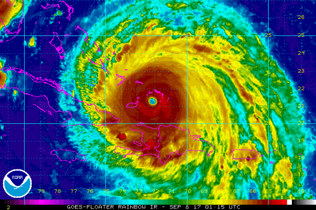
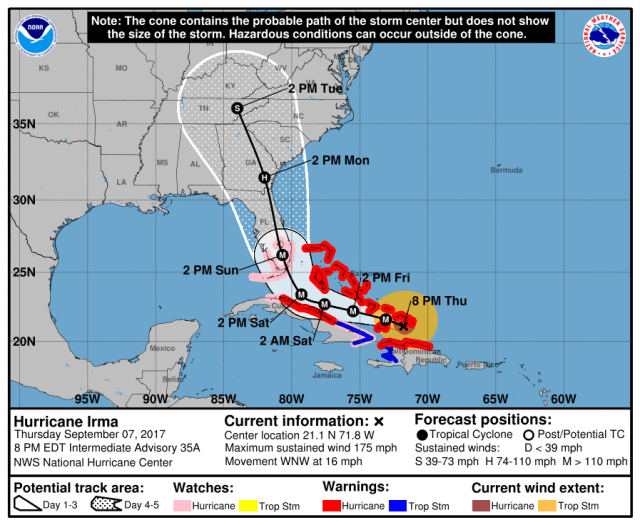
Hurricane Irma has remained an extremely impressive hurricane, and despite a bit of weakening is still a category 5 hurricane this evening with maximum sustained winds of 175MPH. Irma is bringing these destructive winds to the Turks and Caicos as of this writing, and unfortunately scenes like what have come out of the northeastern Caribbean Islands will likely come out of this region. Irma will continue moving west-northwest over the next couple of days, taking the storm into parts of the Bahamas, close to the northern coast of Cuba, and then towards Florida. Here’s the National Hurricane Center forecast as of 8:00PM EDT Thursday:
Take Home Messages:
- After the Turks and Caicos, Irma will pass over the southeastern Bahamas on Friday as an extremely dangerous category 5 or 4 hurricane. Preparations to protect life and property should be completed. Any islands that get into the core of Irma will contend with destructive winds and a life threatening storm surge. Due to Irma’s large size, less severe but still dangerous conditions will occur well away from the center of the storm.
- Irma will sharply turn to the north on Saturday. Where exactly this occurs will have significant implications for both the rest of the Bahamas and Florida. The general trend today has been for the turn to occur a bit farther southwest, putting southern Florida at increased risk for severe impacts. Regardless, Irma has a large circulation and the Bahamas will be on the stronger side of the storm, so severe conditions could still affect the islands. A shift back to the northeast, taking the core of Irma very near or over more of the Bahamas, is still within the margin for error at this point. Because of this, preparations should continue to be in earnest across the Florida Peninsula and Bahamas. Irma will likely remain at least a category 4 hurricane up until a potential Florida landfall. Heed all evacuation orders.
- Due to Irma’s large size and expected intensity at landfall in southern Florida, the storm will likely be slow to weaken as it moves north. Inland impacts from flooding rains and damaging winds are possible in all of the Florida peninsula, along with a life-threatening storm surge up either coast. A track near or up either coast as opposed to up the center of the peninsula is also possible, which would slow weakening of the storm. Heed all evacuation orders.
- Irma still poses a threat to the Southeast; whether the storm hits Florida and makes it up in a weakened (but still dangerous) state or stays just east of Florida and hits Georgia or South Carolina head on as a stronger storm. Due to Irma’s large size, significant inland impacts would also be possible with either outcome. Preparations should continue across the Southeast for Irma. If you are ordered to evacuate, heed that order.
National Hurricane Center: www.nhc.noaa.gov
US National Weather Service: www.weather.gov
Useful website including forecast models and aircraft recon: www.tropicaltidbits.com
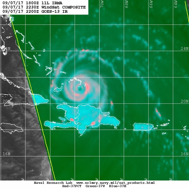
Irma has finally weakened a little bit today, likely due to a little bit of interaction with the mountainous Hispaniola and also inner core changes. The above microwave satellite image reveals that Irma’s inner eyewall has perhaps degraded some (and is not completely closed), while an outer eyewall has developed. Irma has not undergone an eyewall replacement since it rapidly intensified to a category 5 hurricane Tuesday morning, but appears to be trying to undergo one now. If the eyewall cycle actually occurs this time (there have been at least a couple of false starts), the hurricane would perhaps weaken a bit and expand initially. If the eyewall cycle completes, the new inner eyewall could perhaps allow for re-intensification. In short, Irma may fluctuate in intensity over the next day as the inner core of the storm tries to work itself out. This is little consolation to the Turks and Caicos and southeastern Bahamas, as Irma will be an extremely strong storm regardless of these inner core changes.

The main players steering Irma over the next several days are already present on water vapor imagery. Irma is still being steered by ridging over the sub-tropical Atlantic. This ridging extends west to near Florida, though may be eaten away some by the weekend as the trough over the Plains dives southeast. Irma will continue moving west or west-northwest until it runs into the western edge of the ridging. If nothing changed now that’d cause a turn to the north near the Keys…but with the incoming upper-level energy expected to eat away at the western edge of the ridge Saturday and Sunday, that turn will likely occur a bit farther east. Exactly how quickly the ridging gets eaten away at, and how far west Irma gets before the turn occurs are important.

When comparing yesterday afternoon’s European ensemble to this afternoon’s valid Saturday morning, the trough over the Northeast is perhaps just a bit quicker to be moving east, but any difference is very small. Note how the little kink in the isohypses (lines of equal geopotential height) over the south is located over Arkansas and Louisiana on Thursday’s run, but over Alabama and Mississippi on Wednesday’s run. This is the energy diving SW out of the Plains that will cause Irma’s turn and pick it up over the weekend. If this piece comes in slower and farther west, Irma gets a bit farther west before the turn, especially with no substantial trends with the Northeast trough. Still a bit early to know for sure precisely how Irma interacts with this trough, so some changes may still occur.
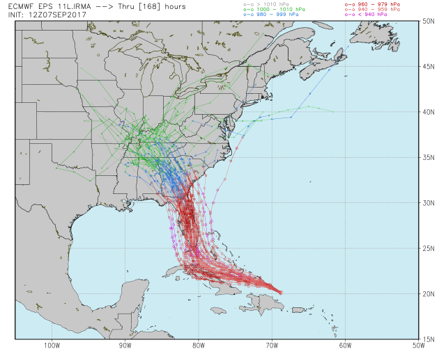
The GFS and its ensemble have generally been farther east with Irma over the last couple days of runs, threatening the Southeast more than the Florida peninsula. The Euro and its ensemble have consistently been farther west with Irma, threatening the Florida peninsula more. Although the future path of Irma is not yet known, check out how the two models have been doing with the track so far:
GFS:
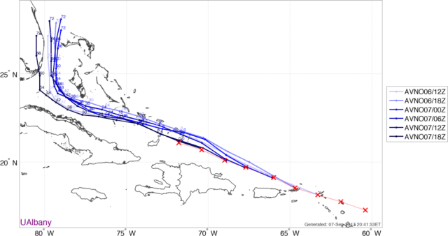
The GFS has consistently been too far northeast with Irma’s short term track, and the last few runs have shown the turn occurring farther southwest, bringing the threat closer to Florida.
Euro:

The Euro hasn’t had much of a bias in the short term with Irma over the last couple days’ worth of runs, and was initially farther southwest than the GFS. The Euro has, despite starting farther southwest, also trended a bit farther southwest with its recent runs.
Due to the incoming trough being a bit slower (and due to no help from the Northeast trough), and the short term motion continuing to follow the southern Euro, the farther southwest and delayed turn trend in the guidance today seems legitimate. There is still time for additional trends, either way, but the chances for Irma to miss Florida to the east appear to be diminishing. This may be better news for the northern Bahamas, though persons on those islands should continue preparations, as it wouldn’t take much of a trend back the other way to bring severe conditions to the northern Bahamas…and indirect impacts from heavy rain, wind, and some storm surge are likely unavoidable due to Irma’s large size.

The GFS ensembles, like the operational model, have trended west today. There’s still spread from the Carolinas to just west of Florida, but the mean has trended west. Again, due to the incoming trough being a bit slower and Irma’s farther south track in the short term, this trend seems reasonable, and puts Florida in a likely position to be hit directly. Significant impacts would extend north into the Southeast, especially Georgia and South Carolina, with many of these potential tracks. I will say that the two members that are far northeast and hit eastern South Carolina and one that goes over the Outer Banks and into the Mid Atlantic appear extremely unlikely, as there’s little evidence of the northwest motion they have over the next 24-48 hours being likely.
The European ensembles are really zeroing in on Florida today, continuing the western trend noted yesterday. Several members do still miss Florida just to the east and then get up to Georgia or South Carolina, but the number of members out there have diminished since yesterday. If trends for the incoming trough don’t speed up, and if Irma doesn’t start following the northern side of guidance soon, then this outcome becomes less likely. I don’t want to rule it out, but we’d need to see those changes occur within the next day. If they don’t occur, then we appear locked and loaded on a direct Florida landfall.
I’m still skeptical of this turning due west into Cuba, as the ridging doesn’t appear that strong, but a good number of members still show that, and given the implications for Cuba and the intensity as Irma heads north towards the US that’s something we’ll have to continue to monitor. Hopefully the Cuba questions are answered over the next day.
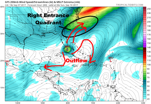
I am very concerned about Irma’s intensity if it hits Florida Saturday night or Sunday. Some signs are pointing to a period of intensification as the storm turns north Saturday into Sunday. Above is a look at the GFS model upper-level winds valid late Saturday night. The right entrance quadrant of a jet streak is located just north of Irma; this would eventually cause shear to impact the core of Irma as it turns north, but would potentially lead to intensification due to outstanding upper-level ventilation before the shear gets to the core of the hurricane.

In addition, the waters as Irma approaches Florida are some of the warmest in the Atlantic basin, and are a little bit warmer than the waters Irma has been over thus far as it’s become and maintained category 5 intensity.
All told, Irma may fluctuate in intensity over the next 12-24 hours as the inner core structure/eyewall cycle work themselves out in an otherwise favorable environment. Irma should remain a category 4 or 5 storm as it moves west-northwest towards the Florida straight. If Irma hits Cuba, it would potentially weaken below major hurricane strength, which is probably the best bet for southern Florida (Cuba would take one on the chin though). There would be some opportunity for re-intensification between Florida and Cuba, but overall a Cuba landfall would still result in a weaker hit for Florida than if Irma stays over water. If Irma stays over water, I expect it to be a category 4 as it heads into the Florida straight. Whether or not the favorable upper-level winds and water temperatures for intensification result in a bump back up to category 5 or not will depend on proximity to Cuba and Irma’s inner core structure at that time. Basically, it’s too early to say. However, the potential for a category 4 or 5 hurricane hit on Florida is distinctly there.
If Irma, by some stroke of luck, turns just east of Florida, it would experience shear as it moved north towards Georgia or South Carolina and would slowly weaken, but would still potentially be a major hurricane at landfall. So basically, we’re looking at a severe hurricane hit wherever Irma hits the US, unless Cuba takes the brunt of the storm first and weakens it at least somewhat.

If the track up Florida pans out, the potential would exist for tens of millions of people to be threatened by damaging winds. This is the European model forecast wind gusts; it landfalls in southwestern Florida and tracks up the spine of Florida into Georgia. Anything in red is hurricane force gusts or stronger on the model; the browns represent gusts on the order of 80-100MPH, the whites and reds represent 100MPH++ gusts. This would cause a lot of damage and millions of power outages, along with storm surge along a lot of coastline. This is just one model projection and may be wrong, but illustrates the power of Irma and how impacts will extend well away from the landfall location. If Irma stays east of Florida and hits Georgia or South Carolina, the swatch of whites and reds corresponding to 100MPH++ gusts would likely extend straight up into those areas. This will be a bad storm wherever it ends up going in the Southeast US. Note how this western track causes more moderate wind impacts in the northern and western Bahamas, but the destructive winds are still very close. This will likely adjust some as we get closer, so anyone anywhere near the projected path needs to prepare for impacts until told to do otherwise.
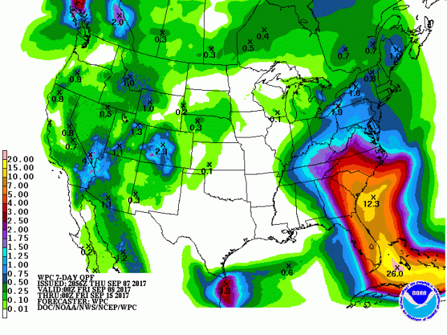
Due to Irma’s large size, it will bring a lot of rain along with a potential for freshwater flooding for a lot of areas. Above is the current projected rainfall through Thursday evening, with a large portion of the Southeast and southern Mid Atlantic seeing enough rain to cause flooding issues.
There’s still time for Irma’s exact track to adjust, which will have large impacts in the Southeast US and Bahamas. A large area will be subjected to damaging winds and potentially flooding rain, with storm surge along a large section of shoreline. It’s too early to pin down who will see the worst impacts, but preparations should be ongoing in all of the Florida Peninsula, Georgia, South Carolina, and North Carolina. Heed the advice of local officials as we continue to refine the exact track of Irma over the next couple of days. This will be a doozy.
