

Month to date temperature anomalies for October.
Winter weather lovers have suffered through a very warm start to the fall so far; temperatures across almost the entire eastern United States have been 5 to 9 degrees warmer than average for the first 24 days of October after a very warm September. The leaves have been slow to change, many areas haven’t seen frost yet, and don’t even think about snow.
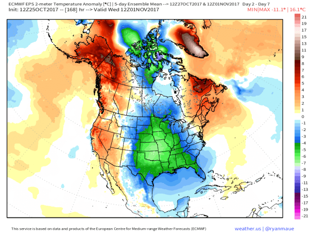
European model ensemble surface temperature departures from Friday morning through Wednesday morning.
The good news? A cooldown is finally affecting parts of the central and eastern United States, with many areas poised to see several days to a week of mainly below normal temperatures. An exception will be New England, as the initial cold is dumping in too far west to cool them off for a prolonged period of time.

European model ensemble forecast upper-level weather pattern valid Monday morning.
The main source of the incoming cold air will be a very large ridge in the jet stream over the West Coast and into northwestern Canada and Alaska; this will cause the jet stream to cascade down over the Rockies and into the Plains, bringing some very cold air with it. In mid-winter, when the “wavelengths” or distance between ridges and troughs is longer, this would probably result in a colder pattern for the East Coast than what we’ll see over the weekend and into next week. However, since it’s not yet mid-winter, and because the North Atlantic Oscillation, or “NAO,” is not strongly negative, this upcoming cold will be centered over the central part of the country with only some of it getting to the East Coast at times over the next week.

GFS model snowfall through Saturday, November 4th.
This blast of cold will result in a lot of areas in the central and interior eastern US seeing their first freeze or frost, and some snow, especially over the Upper Midwest and northern Great Lakes. In the east, since the expectation is they’ll mainly be seeing “leftover” cold from the Midwest, snow will likely be confined to the higher terrain and be spotty at best in the short to medium range.
How Long Does This Pattern Last?

European ensemble forecast upper-level weather pattern for November 4th.
There won’t be a huge pattern change anytime soon, as there’s good agreement on the large ridge over the west and into Alaska (called a –EPO) remaining in place. Despite the large and persistent –EPO ridge, it still doesn’t look like the eastern US will be particularly cold; this is due to how far west the ridge is, with the coldest of air dumping into the Rockies and northern Plains. With no real –NAO (it’s neutral at best in this projection) there’s nothing to force cold into the east, so the trough over the western US encourages a weak Southeast Ridge to crop up. Obviously, some changes could get cold into the east with this type of –EPO pattern, but at this point my bet is the east reverts back to a milder (but not extremely warm) pattern after next week, with the northern tier and west running colder. Northern New England and Upstate New York could be far enough north to contend with the colder weather and perhaps some wintry precip threats.

European ensemble model projected upper-air pattern for November 9th.
This pattern is expected to have staying power as we head towards mid-November, with the –EPO remaining very persistent but the Atlantic side not cooperating for eastern US cold. This is a pretty common pattern as we head into La Nina winters, with cold dumping into the west and warmth over the east (especially southeast). The persistent –EPO is a good sign, as if we keep that towards winter as the wavelengths get longer, cold would eventually get into the east at times. In the shorter term though, signs point against persistent cold over the east.
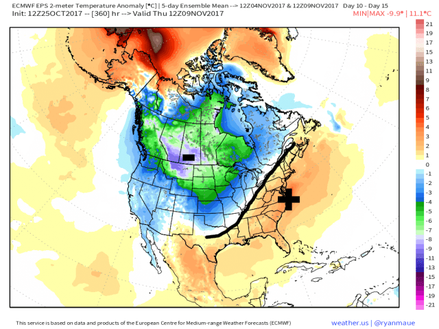
European model ensemble projected surface temperature departures from November 4th through 9th.
The surface temperature departures reflect the amount of cold expected to be forced south on the east side of the –EPO, and also hints at the potential Southeast Ridge development. Winter lovers in the east won’t want to hear this, but when the west is that cold, it is hard for the east to be cold unless there’s a –NAO. That’s why I’m in general agreement with the mild start to November (after lingering cold for the first few days) in the east, though with so much cold lurking just to the northwest some occasional cooldowns behind any larger storms would be likely. It won’t be persistently warm, and a fluky snow event can’t be ruled out in the higher terrain or interior Northeast well inland from the coast, but there may be 3 or 4 warmer days for every colder day in this type of pattern.

European ensemble MJO index forecast for the next two weeks.
Large areas of thunderstorms in the tropics are a key driver to the jet stream during the second half of fall and winter, and an index that measures atmospheric factors that influence those complexes of thunderstorms is called the “Madden Julian Oscillation” (or MJO). The MJO has well known correlations to the mid-latitude weather pattern; for instance, phases 6 is typically warm this time of year in the central and eastern US, while phases 7 and 8 are colder (though with some hints of a Southeast Ridge):

Typical temperature correlation over the continental US in the various MJO phases.
Though these correlations are by no means perfect, the MJO has done a good job of predicting the recent change from warmer to colder, and even does a good job of suggesting the coldest of the cold centered over the northern Rockies, Plains, and Midwest, with some trouble getting it into the east.
The forecast is for the current MJO wave to weaken during early November, perhaps suggesting the already La Nina-like pattern will remain locked in place for a little bit. My current guess at this point is that we see some semblance of a –EPO continue through at least mid-month, with colder temperatures focused in the west and a Southeast Ridge trying to keep the east warm. It wouldn’t surprise me if the Southeast Ridge expands a bit between November 10th and 20th, keeping the eastern US on the mild side. After that, we’ll watch for perhaps a change in the pattern as we near Thanksgiving.
