
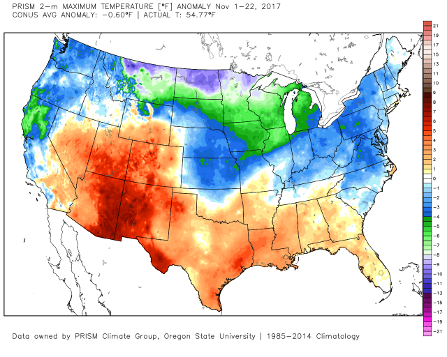
Month to date temperatures departures for November through 11/22/17
A generally cold week in the eastern US has eaten away at the warm departures over the Southeast on this map a week ago, and now overall the continental United States (CONUS) is running a -0.6 degree departure for the month of November…this isn’t an earth-shattering value, but the last November that saw a negative temperature departure overall in the CONUS was 2014, so this is a shift from the last couple of falls.
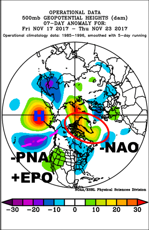
Observed upper-level (500mb) weather pattern over the last week across the Northern Hemisphere
The story of the last week has been a favorable Atlantic (-NAO) and unfavorable Pacific doing battle over the central and eastern US. The result has been a mild trough and predominantly colder than normal conditions over the east and a mild ridge and warmer conditions in the west, but due to the conflicting signals neither area was able to really lock in. With a –PNA (ridging over the Aleutians and a trough just off the West Coast) and +EPO (troughing over Alaska), had the –NAO not been there it likely would’ve been a pretty mild week in the central and eastern US. So, the –NAO had an impact, despite what you may read elsewhere, but the northeast saw very little snow and that was mainly in lake effect areas and upslope areas in northern New England. This is a good example of how a –NAO can fail to produce a winter storm over the eastern US (which happens quite often), but also of how a –NAO can try to overcome a poor pattern elsewhere. It’s all connected and you can’t just look at one index and hope to make a successful forecast. Had the Pacific been better, the trough over the eastern US likely would’ve been a good bit deeper, so there was destructive interference over the eastern US due to the conflicting signals.
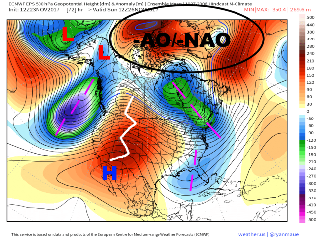
European ensemble forecast upper-level weather pattern valid Sunday 11/26
Over the next few days, a similar trend will continue with a –AO and –NAO (not a classic block, but upper-level heights projecting onto the loading pattern for a –NAO at least) allowing for troughing and cooler conditions in the east, but a less than hospitable Pacific pattern keeping the cold shots relatively transient and unproductive.
A negative height anomaly over the Bering Sea and Alaska (centered too far north to allow for a true +PNA) will keep the Pacific jet strong, limiting how tall ridging over the western US gets, and pushing the trough over the Northeast out of the way fairly quickly. There were some rumblings of a potential storm late this weekend over the Northeast, and I said last week there was some legitimacy to that idea…however, the ridging over the western US just won’t get tall enough to allow the northern stream shortwave to amplify quickly enough to have any interaction with the sub-tropical jet shortwave over the Southeast. This will result in yet another unproductive cold shot in terms of snow, with the only chance for accumulating snow being downwind of Lake Ontario due to lake effect and in the upslope areas in northern New England. The cold and minimal amount of natural snow will help some of those ski resorts a little bit, but everyone else will be left out.

European ensemble forecast upper-level pattern valid Wednesday 11/29
The pattern will turn from one marginally supporting colder conditions over the Northeast currently to one supporting mild conditions pretty quickly next week. The EPO will remain positive with no real help from the PNA, and although the AO will remain negative, with higher heights projecting onto the –NAO loading pattern, it won’t be a favorable NAO block. Note how the higher heights are centered east of Greenland (so, it’s “east-based”) and how it’s not a block (closed height contours) so much as a “thumb ridge” in the north Atlantic. This doesn’t slow down the jet stream over the western Atlantic, and in fact helps it speed up. This all results in the polar jet stream contracting northward over North America, allowing mild air to build north and east over a large portion of the CONUS. A large vortex near Alaska is rarely favorable for a lot of cold in the CONUS.
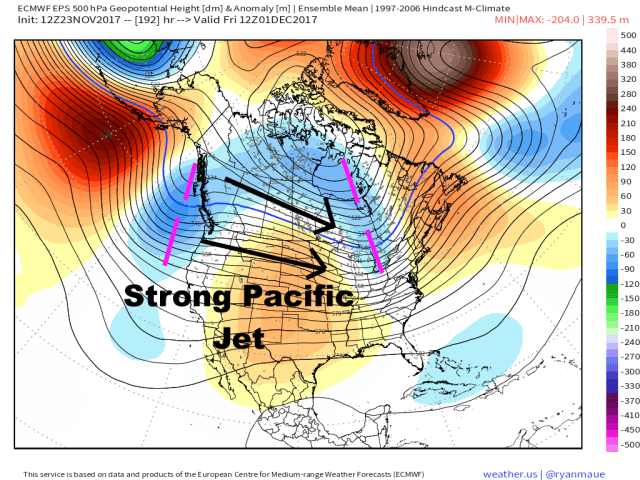
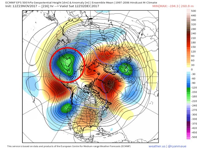
European ensemble forecast upper-level pattern valid Friday 12/1
To start December, both the GEFS and EPS suggest a transient trough moving over the eastern US, but with no help on the Pacific side and only a north Atlantic thumb ridge (as opposed to a classic NAO block), this trough will only bring a brief “break” from the milder weather…maybe a day or so of near or slightly cooler than normal conditions, and likely no real snow threat.
All signs point to a pretty mild first week of December:

MJO forecasts from the GFS ensemble (left) and European ensemble (right) for the next two weeks
There is good agreement on the MJO moving through phases 4-5-6 over the next two weeks, all of which correlate to warmth over the central and eastern US. This has been hinted at for several days and although the MJO looks weak (barely out of the “circle of death” or circle of indetermination), the decent agreement makes it a more credible factor to consider.
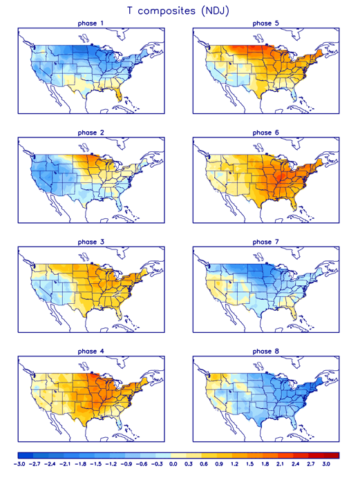
Correlation to temperature in each MJO phase
Note how phases 4-5-6 are decidedly “warm phases” in the MJO over a large portion of the US. The MJO is passing through these phases while the ensembles forecast the following teleconnection: -PNA (warm), +EPO (warm), +WPO (warm), -AO (cold but doesn’t say where the cold goes), -NAO (but east-based and more of a thumb ridge than a true block):

GFS ensemble teleconnection forecast for the next two weeks
This all suggests a good period of mild weather can be expected for the last couple days of November and first week of December. Given pretty good agreement on all signs pointing towards “warm,” the potential does exists for a couple or few days of pretty substantial positive temperature departures over the central and eastern US. The ensembles both agree well with the signs pointing towards warmth over the central and eastern US, and show a period of mild/warm conditions:
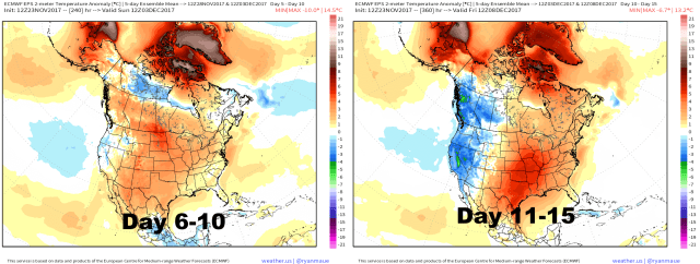
European ensemble forecast medium to long-range temperature departures

GFS ensemble forecast medium to long-range temperature departures
Both ensembles have warmth in the 6-10 and 11-15 day periods in the central and eastern US, though the Euro ensembles are generally warmer than the GFS. The higher heights in the north Atlantic do project onto the –NAO loading pattern, but it’s not a traditional block, and just about every other index is unfavorable for cold in the central and eastern US. So despite the EPS’s warm bias in November, I’m a bit more inclined to lean towards more EPS than GEFS at this juncture through the first week of December.
This warm-up does not appear to be a long term thing:

European ensemble forecast upper-level pattern valid 12/8
Both sets of ensembles agree on the pattern improving for cold in the eastern US by the second week of December, and have shown these hints for several runs. Both ensembles back the higher height anomalies back towards Greenland by the end of their runs. This is a long range out and NAO predictability is iffy at best, but this is a consistent signal on both ensembles for a potentially more favorable NAO block developing. In addition, both ensembles are showing lower heights over the northwest Pacific, allowing potential height rises on the West Coast into Alaska, suggesting the PNA may rise and the EPO may fall by the second week of December. All of these teleconnect to colder conditions in the eastern US. The AO is also slated to remain somewhat negative, suggesting an amplified pattern with big ridges and dips in the jet stream is possible.

GFS ensemble forecast upper-level pattern valid 12/8
The GFS ensembles show a similar picture…some differences but overall similar. Higher heights backing west towards Greenland, suggesting a potentially more helpful –NAO, and heights rising on the West Coast and into Alaska, suggesting a falling EPO and rising PNA…again, all support a trough/colder weather in the eastern US, and the GEFS actually pop some negative height anomalies over the east by this point.
Reference the above MJO plots…good agreement on the MJO possibly approaching phase 7 by the end of week 2, which correlates to these colder conditions. I suspect the MJO will weaken before it gets too far into the cold phases, but it does appear it gets past the warm phases by the time the ensembles start hinting at the colder pattern over the eastern US.
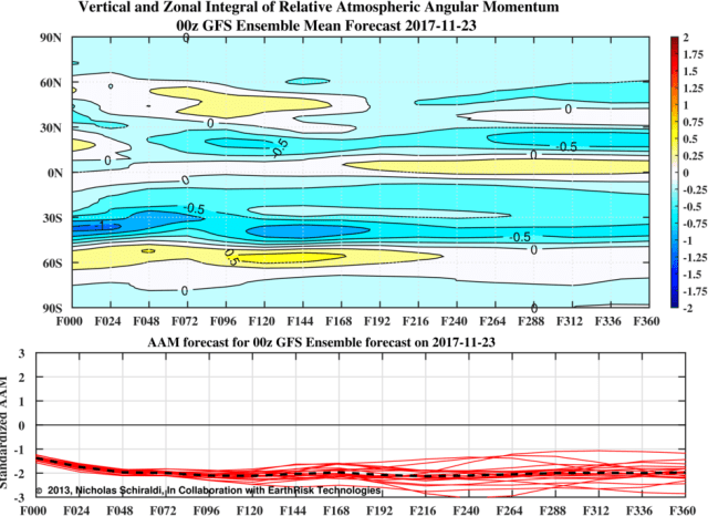
GFS ensemble forecast Global Atmospheric Angular Momentum forecast for the next two weeks
The GFS ensembles maintain a negative AAO for the next two weeks, meaning the pattern is expected to be more La Nina-like with an amplified/meridional jet stream. Note how in the top portion of the graphic, negative AAM (blue) is focused in the mid-latitudes (especially north of 40N) and high latitudes in the northern hemisphere, suggesting a generally meridional/high latitude blocking pattern. This suggests colder air may be more readily available in the sub-polar regions.
European ensemble northern hemisphere forecast upper-level pattern valid 12/2
The GFS and Euro ensembles have both consistently shown a prolonged and intense polar vortex displacement over NE Asia in the mid to long-range. This is a known conduit to the momentum transfer up into the lower stratosphere and potential precursor to a stratospheric warming events. Stratospheric warming events can cause tropospheric high-latitude blocking patterns if the strat and troposphere couple properly. It’s worth noting it’s difficult to guess if a strat warming event will occur, if it will affect the troposphere, and where the cold will go. A potential stratospheric warming event does NOT mean your backyard will be cold.

European model forecast for the mid-stratosphere (50mb) valid 11/29
In response to the tropospheric pattern, the GFS and Euro have been showing an interesting 3-wave pattern in the lower to mid-stratospheric polar vortex developing within one week. I am not a stratospheric expert, but some (@antmasiello and @chionomaniac) on Twitter who are much better versed than I say it’s unusual. To me, it would seem at the least it suggests the stratospheric polar vortex won’t be intensifying much in the short term.
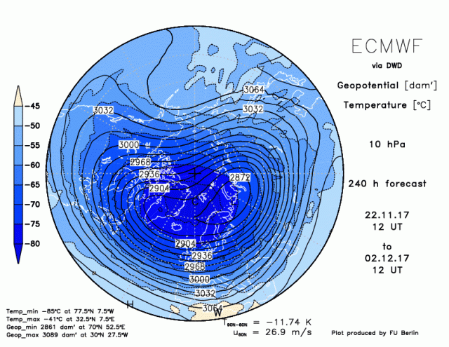
European model forecast for the upper stratosphere (10mb) valid 12/3
The GFS and Euro both show the upper-stratospheric vortex becoming perturbed by 10 days out, with the GFS showing further displacement after day 10. How this affect the tropospheric weather is unknown…because it’s not certain yet how significant any displacement of the PV, whether it will just displace or split, where it will go, and how it will couple with the troposphere. Any impact on the troposphere would be a few weeks away from this writing.
However, with the seeming tendency recently for a –AO and –NAO, with that continuing for the next two weeks at least in all likelihood, if this displacement occurs it may encourage continued blocking that supports cold over the central or eastern US down the road if the stratosphere and troposphere are coupled. This is not very certain yet, but fits the theme showing up on the medium range ensembles and long-term European weekly model forecast, and my analogs for December which suggest a NE Asian Vortex, higher heights near Alaska, higher heights near southern Greenland, and cold over much of the north-central and northeast US.
My forecast is for a mild to very mild end of November and first week of December, with colder air building into the east during the second week of the month and perhaps persisting for most of the rest of the month, especially if favorable high-latitude blocking develops and persists. This is similar to my forecast from the last two weeks but with higher confidence. If we see a favorable –AO and –NAO as the West Coast heights rise, the potential for more meaningful snow will develop from the Midwest and Ohio Valley/Great Lakes into parts of the Northeast. Whether or not the NAO is negative may determine if locations farther west such as the Ohio Valley and Great Lakes are favored or if locations east of the Appalachians are also in the game.
A Word about the La Nina

Current global sea surface temperature anomalies
The La Nina has intensified over the last two weeks and expanded west some, with the Nino 3.4 region (usually used to gauge the strength of El Ninos and La Ninas) now right near -1.0 degrees C, the threshold for a weak and moderate La Nina. The sub-surface in the tropical Pacific remains quite cold as well:

Water temperature anomalies with depth over the Tropical Pacific
With a cold sub-surface, pretty chilly surface, and MJO over the eastern Indian Ocean/western Pacific Ocean over the next couple of weeks promoting easterlies over the ENSO regions and further upwelling of the cold water, this La Nina will likely dip safely below -1.0C soon and stay there for a little while. We may not get a monthly value of -1.0C or lower (though it will be close in December in my opinion), but this is a legitimate La Nina and won’t weaken quickly enough to not impact the winter. If we lose the –NAO and –AO tendency by say January, the Southeast Ridge will flex its muscles at times and warm up the eastern US. That’s still a long way off and we’ll see how things keep involving in the shorter range…as continued high-latitude blocking and/or an active MJO can mitigate it. But I am throwing caution to anyone who wants to dismiss this La Nina’s potential impact on the winter. Cold is favored in the northern Rockies and Plains during a La Nina with milder conditions in the south and east during a La Nina…you need other factors to override that. It looks like we’ll get that in December. If those factors relax later in winter warmth will bubble back up in the east and the cold will back farther west.
Stay tuned for next week’s update on Wednesday or Thursday.
