
Disclaimer: The thoughts in this post are only mine and don’t represent the thoughts of any other companies, groups, websites, or organizations. They also shouldn’t be used for decision making in the impacted areas…
The majority of the satellite and model images in this post are courtesy of Tropical Tidbits. Any poorly drawn illustrations on the images are my own.
Now the post…
Main takeaways:
- Florence’s weakening trend is over, and the storm will likely become a hurricane again by Sunday and a major hurricane again on Monday or Tuesday. Peak intensity as a category 4 or 5 hurricane over the western Atlantic is likely.
- Florence will accelerate to the west-northwest into the western Atlantic, south of Bermuda, over the next several days.
- The odds for landfall on the U.S. mainland on Thursday or Thursday night are increasing and are now more likely than a miss to the east. I suspect the Carolinas would be the most likely landfall location, though a direct impact on Georgia, northern Florida, and perhaps eastern Virginia can’t yet be ruled out.
- Florence would likely make landfall as a major hurricane if it hits the Southeast U.S., bringing a substantial wind damage and storm surge risk in the areas directly impacted.
- Florence would likely slow substantially and perhaps stall just inland if landfall occurred, bringing a substantial risk for severe fresh-water flooding as well. The risk for flooding could leak farther north into the Mid Atlantic by the end of the week or next weekend.
- A miss just to the east with no direct landfall still is possible at this juncture. If you’re not an idiot, you’ll root for that solution over the next couple of days, but it’s important to note that it unfortunately just is not the most likely outcome as of this writing.
Discussion:

Satellite image of Florence Saturday PM
Florence’s days long battle with moderate to strong shear and dry air is coming to an end. The shear has relaxed, allowing the circulation to become vertically aligned once again, with the low-level center under the deep convection. It does appear there’s still a considerable amount of dry air entrained into the circulation as the convective structure is a bit bare-bones at the moment, however, there is a relatively intense and organized curved band that may have some developing inner-core structure. The storm itself is quite large, with a rather low minimum pressure from a tropical storm (989mb) and already has expansive outflow in all quadrants. Once the dry air is mixed out and deep convection fires more persistently, the storm appears to have the pieces in place to become a large and very powerful hurricane as it moves west-northwest.
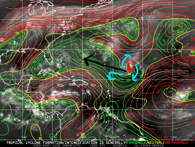
Current shear across the Atlantic
Shear analysis from Saturday afternoon shows Florence is already under a developing upper-level anti-cyclone, which is acting to fend off stronger winds from an upper-low to its north. The map does also on its face appear to show a corridor of favorable, low-shear conditions ahead of Florence.
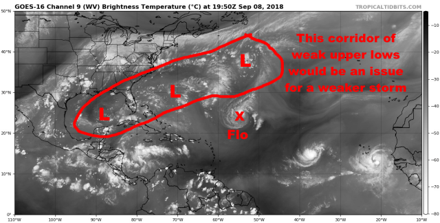
Current water vapor across the Atlantic
There is an expansive corridor of weak upper-level lows that could in theory cause increased wind shear ahead for Florence, but unfortunately Florence’s size and intensity will likely allow it to dodge any weak punches the atmosphere will attempt to throw at it over the next few days.
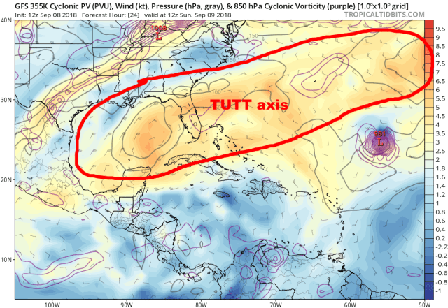
GFS model depiction of the upper-level lows valid Sunday
You can see this happen on the GFS…the model has an axis of upper-level lows/disturbances ahead of Florence in the short term, but…
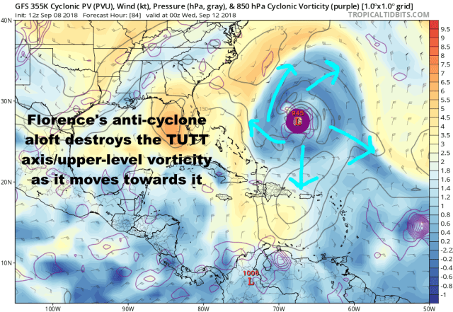
GFS depiction of the upper-level lows and ridges valid Tuesday
As Florence intensifies so does its upper-level anti-cyclone, and this helps the storm power through the mine-field of weak upper-level disturbances that could shear the storm. It almost becomes a positive feedback, as the upper-disturbances act to help ventilate the storm at the top of the troposphere, strengthening the storm and its anti-cyclone even more. The GFS has a habit of being a little too aggressive with this process, however, the Euro has consistently shown the same thing:
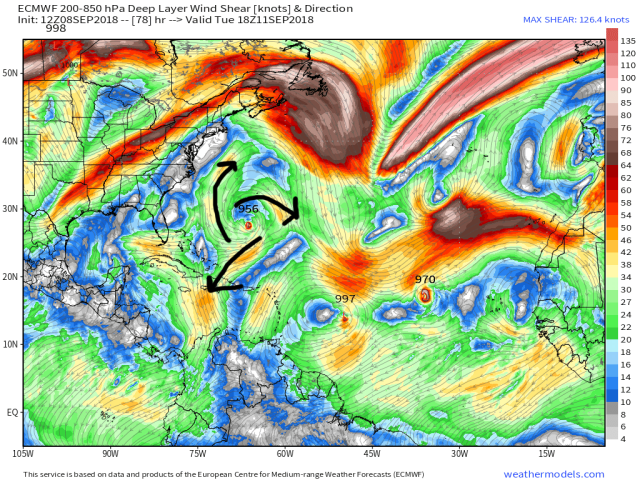
European model forecast wind shear Tuesday PM
Slightly different plot, of the deep-layer shear, but the flow is clearly anti-cyclonic away from Florence with any stronger shear staying away from the storm.

Current water temperatures (C)
With the very favorable upper-level wind pattern expected and Florence moving over 29-30C SSTs (mid 80s) all the way up until the Southeast US coast, the ingredients appear to be in place for Florence to become a very powerful hurricane during the first half of this week. The storm already appears to have the pieces in place once it can mix out the dry air.

GFS model forecast mid-level relative humidty valid Sunday
The environment ahead of Florence does have a modest amount of dry air in the mid-levels, nothing worse than normal for this part of the Atlantic, and certainly not the Saharan Air Layer the storm battled last week over the eastern Atlantic. GFS storm-average forecast soundings show the mid-level RH rising above 70% on Sunday and about 80% for Monday and Tuesday, which is plenty high that when combined with little shear to tilt the circulation and entrain dry air in…and good outflow and warm waters promoted vigorous convection…that dry air intrusions shouldn’t be a hindrance to re-intensification over the next few days.
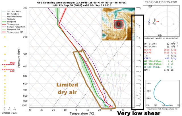
GFS model forecast sounding valid Monday evening for the environment around Florence
Here is a look at a GFS forecast sounding valid Monday evening for the environment around Florence, showing minimal shear (less than 5 knots) and fairly limited dry air (mid-level RH of near 80%, which is favorable for intensification).
All told, Florence will certainly become a large major hurricane over the western Atlantic during the first half of this week. The only real questions are does it mix out the dry air and start rapidly intensifying on Sunday or Monday, and does it max out as a category 4 or category 5 storm? The difference in potential impacts down the road isn’t much as this is a substantial risk either way if it makes landfall as a major hurricane.

European model forecast upper-level winds Wednesday evening
Unfortunately for the Southeast U.S., if Florence does make a direct landfall it appears that the unusually strong ridge pushing the storm west towards the coast will also keep the jet stream and any notable wind shear well north and west of the storm until after it made a possible landfall. If Florence missed the Southeast and worked farther up the East Coast then it’s possible that southwesterly shear and cooler waters would have an impact…but if this makes landfall from North Carolina points south, the only things that appear to possibly weaken the storm are internal dynamics (eyewall cycles) and perhaps, perhaps some entrainment of continental dry air if the storm slows upon approach. Essentially, I struggle to see how this doesn’t maintain at least major hurricane intensity if it goes into the Southeast. If the storm slows significantly coming in, or goes farther north, then it’s possible it weakens further.

Current steering pattern across the Atlantic Ocean
The current steering pattern near Florence shows what was, at one time long ago, supposed to be Florence’s opportunity to recurve harmlessly out to sea. As has been discussed ad-nauseam by everyone, that isn’t happening as ridging is quickly building over the western Atlantic. This ridge will become the dominant steering feature into the first half of this week for Florence, causing it to accelerate to the west and west-northwest through the middle of the week. This will take Florence south of Bermuda and dangerously close to the Southeast U.S. coast.

European ensemble forecast steering pattern valid Wednesday evening
The ridge will be very strong over the western Atlantic through much of the week, near record strong for this region this time of year, and this will cause Florence to maintain a west-northwest heading to dangerously near the Southeast coast. This much is agreed upon. It’s the exact location of the western edge of the ridge that is still somewhat in doubt, and is the only factor that suggests that a last second recurve is still not completely ruled out.
Note that on the above image that the European ensemble mean does have the heart of the ridge off the East Coast itself, so there is some opportunity for a last second turn…but also note that well-above average heights extend west into the Mid Atlantic, suggesting that the window to turn is probably not enough to avoid landfall unless the western edge of the ridge is weaker and farther east than the majority of the European ensemble members have.

European ensemble forecast steering pattern valid Thursday evening
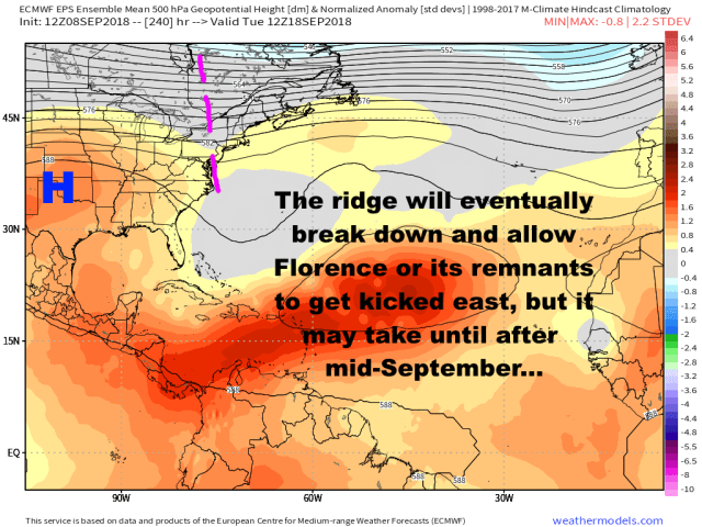
The European ensembles do eventually weaken the western Atlantic ridge…just a little bit…but by that point it’s too late, as Florence would have already made a Southeast U.S. landfall, and because an intensifying ridge over the Ohio Valley would probably prevent much if any north/northeast motion…if anything this would just cause Florence to slow considerably and essentially stall for an extended period of time until the ridging can break down and a shortwave can come in and kick the storm or whatever is left of it out…which, might be a while..
European ensemble steering pattern forecast valid 9/18
This means that if Florence does not curve east and slow down/stall just offshore, that it would bring a lot of rain to parts of the Southeast and perhaps Mid Atlantic for quite a while before the eastern U.S. finally gets cleared out several days after potential landfall.
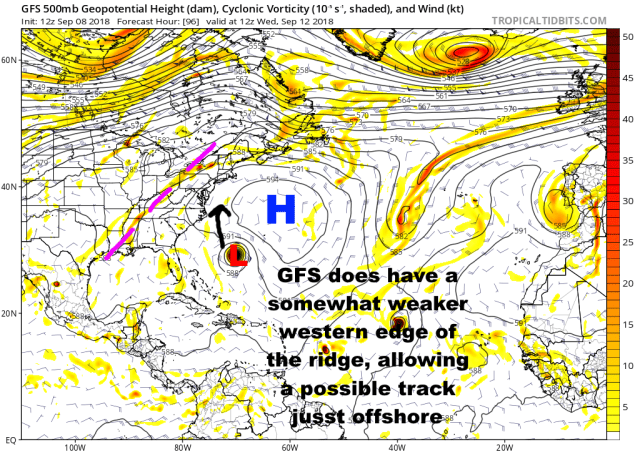
GFS model steering pattern valid Wednesday morning
The Saturday 12z GFS run showed the alternative, much less impactful solution for Florence. The model had a weak shortwave erode the western edge of the ridge just enough that Florence was able to turn north and end up east of North Carolina/the southern Mid Atlantic before ridging building over the Ohio Valley/Great Lakes forced a stall for a few days just offshore.
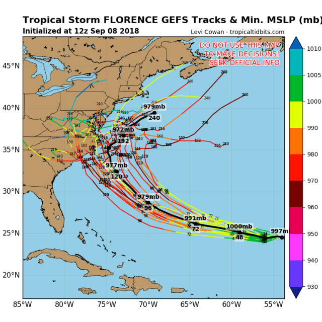
Saturday afternoon GFS ensemble member forecast tracks
The GFS suite is generally more optimistic about the chance for a very close miss than the European suite this afternoon, but still, it’s at least half or a little more of the members that manage to make a landfall in the Carolinas…in addition…

Forecast trend for mid-level heights from the GFS ensemble
The trend over the last two days’ worth of GFS ensemble runs has been to intensify the ridging north of Florence that would need to weaken quicker to allow for a curve just east of the Carolinas. This trend has slowed a bit in today’s run, but the more extended range GEFS runs were too weak with this ridging…not a good sign that the suite that’s been consistently more optimistic about curving Florence off the coast has gradually been trending away from that idea.
Let’s take a look at the last two cycles of the European ensemble and the member track forecasts…

Friday night European ensemble member forecast tracks
A small cluster (slightly more than 10% of the members) misses the coast. The rest hit somewhere. The majority hit SC, GA, or FL, with another notable cluster hit NC and/or extreme SE VA. This is not going into the Gulf.
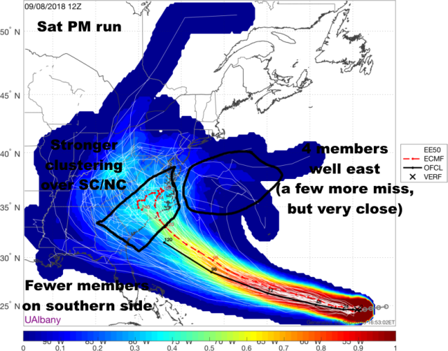
Saturday afternoon European ensemble member forecast tracks
The 12z EPS generally shed some outliers on both side…though a few members hang on to a GFS-like solution. The members that make landfall did cluster a bit more on SC/NC than the 0z run. This was overall a modest right trend, but the number of recurves east of the U.S. did not increase.
At the end of the day, my impression is that the European suite has generally led the southwest trend with Florence over the last several days (with a nod to the UKMET at well that remains on the southern side of the envelope). With ridging remaining strong until Florence is essentially just off the Carolina coast on Wednesday, and then perhaps only weakening briefly before more ridging builds in over the Ohio Valley/Great Lakes, and a large majority of EPS members continuing to show hits, a curve to the east of North Carolina while still possible just feels like a bit of a long-shot. Unless we start seeing more substantial trends among the European suite away from a landfall idea in the next day or so, we can likely start “locking in” a Southeast landfall. We aren’t quite there yet, but it’s getting close.
If landfall occurs, which at this point I’d say is probably about an 80% proposition, I do suspect that the brief weakness in ridging as it approaches pulls Florence north enough that a NC or SC hit is more favored than a GA or northern FL hit, though all options are still on the table so everyone in the Carolinas…Georgia…northern Florida…and even Virginia should make sure their hurricane plan is in place…while hoping that the increasingly long-shot recurve solution just to the east somehow happens to play out…we should be able to say by Monday if that has a shot of occurring still or not.
As discussed above, Florence if it made landfall would likely be a strong hurricane, probably a major hurricane. This would obviously bring a damaging wind and storm surge risk to the coast. However, with ridging building in north of the storm as it makes its possible landfall, the risk for a stall or prolonged slow motion just inland is high…which means the risk for someone in the Southeast or perhaps southern Mid Atlantic seeing very heavy rain and significant fresh-water flooding is quite high if Florence makes landfall.
If Florence makes landfall it would be a severe impact in the Southeast, with perhaps flooding rains getting north into the Mid Atlantic…the odds of landfall are becoming increasingly high but aren’t 100% yet, so we’ll continue watching for a window for it to curve just to the east of the U.S. coastline. With landfall risk appearing to continue to increase however, those potentially in the path should make sure their hurricane plan is in place and ready to be put into action early this week if landfall continues to look likely.
