
Disclaimer: The thoughts in this post are only mine and don’t represent the thoughts of any other companies, groups, websites, or organizations. They also shouldn’t be used for decision making in the impacted areas…
The majority of the satellite and model images in this post are courtesy of Tropical Tidbits and Weathermodels.com… Any poorly drawn illustrations on the images are my own.
This will likely be my last post on Florence, and preparations should already be well-underway in the impacted areas. If you have interests in the affected areas, you should seek official info and follow orders from local officials.
Now the post…
Main takeaways:
- Florence is currently a category 4 hurricane, and there appears to be some room for additional intensification between now and Wednesday evening.
- Florence is still likely to make landfall in the Carolinas on Thursday, perhaps just east of the South Carolina/North Carolina boarder. There remains some uncertainty, and anything from a direct hit on South Carolina to a stall just southeast or east of North Carolina without a direct landfall remain somewhat on the table.
- Florence is already a large hurricane, and its wind field is expected to expand further before impacting the Southeast later this week.
- Although Florence will not be at peak intensity when it makes landfall, it is still likely to be a major hurricane with a large wind field. This will bring a substantial wind damage and storm surge risk to the coast.
- Florence’s large size will likely allow strong winds that can down trees and powerlines to make it well inland.
- Florence’s large size and expected slow motion after landfall will bring a risk for severe freshwater flooding from rainfall inland from the coast. This flooding rain may make it north into the Mid Atlantic by Friday or the weekend. This often is the hazard that results in the most deaths from tropical cyclones, along with storm surge flooding closer to the coast.
- Although a lower-impact solution without a direct landfall is still remotely possible, a direct landfall is likely with weather going downhill before the actual center arrives. Given this, preparations should continue to be underway and earnest across the Southeast.
- It’s really too early to say where exactly Florence drifts after its expected landfall. I suspect it’ll slowly drift northwest and then north, and get kicked east next week, but there may be some unforeseen wobbles along the way that won’t be modeled well at this range.
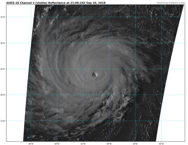
Visible satellite imagery of Florence valid Monday afternoon
One of the better rapid-intensity forecasts ever made has unfortunately panned out from Florence, as the storm has intensified from a tropical storm Sunday morning to a category 4 hurricane by Monday afternoon. The satellite images of Florence are as you’d expect quite impressive this afternoon…with a closed eyewall with vigorous convection completely enclosing a well-defined eye with mesovorticies evident at times on GOES-16 imagery. Anti-cyclonic upper-level outflow is well-established in all quadrants, particularly in the western and northern portions of the storm.
The storm has continued to gradually intensify since its classification as a category 4 around 12:00PM EDT Monday. At the moment, the eyewall features a solid ring of -65 to -70C cloud-top temperatures, with the eye temp of about 15C on IR imagery. If we’re getting nit-picky, the eyewall cloud-temps could be colder and the eye temp could be warmer…so despite the nearly perfect structure, the convective intensity, at this time, just doesn’t suggest a further intensification to category 5 intensity in the immediate future. (side bar, between starting to write this around 5PM and finishing around 9PM EDT, the structure has degraded a little bit, suggesting it is certainly not intensifying at this time).
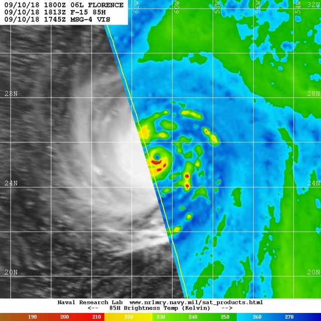
Microwave imagery of Florence from Monday afternoon
A microwave pass from earlier this afternoon shows the well-organized inner core. A secondary eyewall is not yet forming, so if the eyewall convection becomes a little bit more intense then this core could support additional intensification. The outer rainband that’s evident will probably eventually congeal/contract enough to initiate an eyewall cycle, but that doesn’t appear anywhere near imminent.
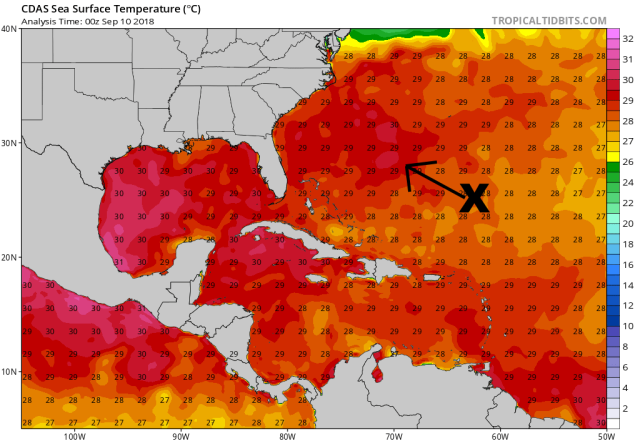
Current sea surface temperatures (C) across the western Atlantic
Florence is not yet over the warmest SSTs of its journey towards the Southeast, as water temps and heat content will increase noticeably as early as tonight. Just on this alone, given the current structure, it’s possible we see convective intensity increase further with tonight’s convective max and support further strengthening of the hurricane. The kinematic environment around the hurricane is also expected to remain as favorable as or perhaps even become more favorable than it is right now…
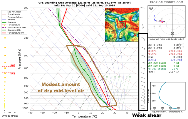
GFS model sounding for the environment around Florence Monday afternoon. Wind in the barbs on the right, temperature and humidity in the middle.
This sounding from the 18z GFS analysis…essentially the current conditions this afternoon…show that Florence is in a weak vertical shear environment, with a uni-directional flow and minimal speed shear below 200mb, and a mean RH of around 70%. This could be a little bit higher, but with little shear and a well-organized inner core, this small amount of dry air is not negatively impacting the hurricane.
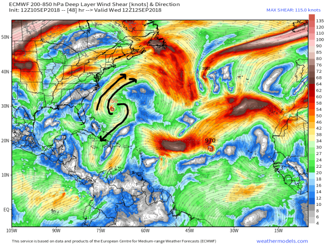
Wind shear forecast from the Euro valid Wednesday morning
The Euro and GFS (Euro shown above for some variety) both show the upper-level anti-cyclonic flow remaining prominent over Florence through Thursday, with the flow expanding/intensifying gradually Tuesday into Wednesday. Both models also suggest that the poleward outflow channel will be enhanced by a modest jet streak over the northwest Atlantic Tuesday night into Wednesday. This all means that the shear will remain minimal through about Thursday morning, with outflow remaining expansive and likely becoming even stronger than it currently is.
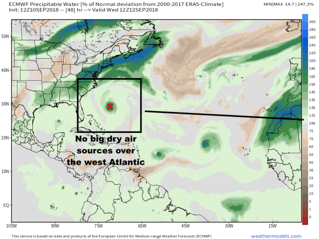
Atmospheric moisture anomaly forecast valid Wednesday from the European model
In addition, dry air isn’t expected to be a potential issue through the expected landfall in the Carolinas, with much of the western Atlantic (and the eastern U.S. for that matter) mired in a more humid airmass than average, due to the same ridge pushing Florence west towards the Southeast coastline causing a lack of shortwaves or cold fronts with dry air that make it far enough south to possibly influence Florence over the next few days.
The combination of warmer waters, continuing low shear, little dry air, and strong outflow that will if anything become stronger strongly suggests that Florence has not yet reached its peak intensity. It’s a possibility that Florence becomes a category 5 hurricane at some point between later tonight and Wednesday night…though there will likely be an eyewall cycle or two at some point that causes a weakening in the overall winds but further expansion of the already sizeable wind field. My impression is that if we don’t see Florence reach a category 5 by some point on Tuesday or Tuesday night…before a likely eyewall cycle begins…that we probably don’t see it peak that high…as the window for the ERC to complete and allow for re-intensification before conditions become slightly less than completely optimal is probably quite small once the ERC starts.
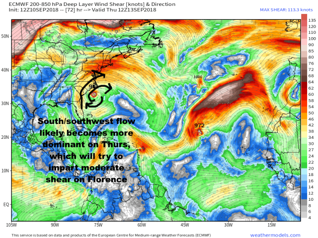
Forecast wind shear from the European model valid Thursday morning
This is due to what will be some likely increase on shear starting around Thursday as a weak shortwave moving through the Northeast likely imparts a strong enough S/SWrly upper-level flow to cause some shear on Florence. The shear won’t be strong and won’t rip the hurricane apart, but a gradual decay starting by Thursday and continuing through expected landfall by Thursday night is likely. Though there is less dry air than normal over the Continental United States as Florence approaches, its diminishing forward speed through landfall does also suggest that any dry air and also friction caused by land over parts of its circulation may also have some brief opportunity to start inducing weakening before likely landfall.
All told, I suspect we see Florence peak as a high-end category 4 or “low-end” category 5 hurricane at some time on Tuesday or Tuesday night, likely fluctuate as a category 3-4 Wednesday into Thursday due to a likely eyewall cycle, and then probably start trending down as Thursday wears on due to some increase in shear and the beginning of land interaction. With that said, assuming the timing holds and we see a Thursday afternoon or evening landfall, Florence will likely make landfall as at least a category 3 hurricane. Depending on the exact timing of the ERC, Florence’s exact intensity before and after the ERC, and its forward speed coming in and ultimately the timing of the landfall, a rare Carolinas category 4 landfall is still possibly in the cards…though I’d put my money on landfall intensity ultimately being in the category 3 range.
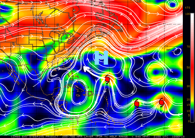
Current steering currents across the Atlantic
The track forecast is relatively straight-forward through Wednesday, and then uncertainty increases around the time of likely landfall in the Carolinas. A strong ridge over the western Atlantic will be the dominant feature steering Florence through Wednesday night, and will impart a west-northwest motion turning perhaps a bit more northwest with time.
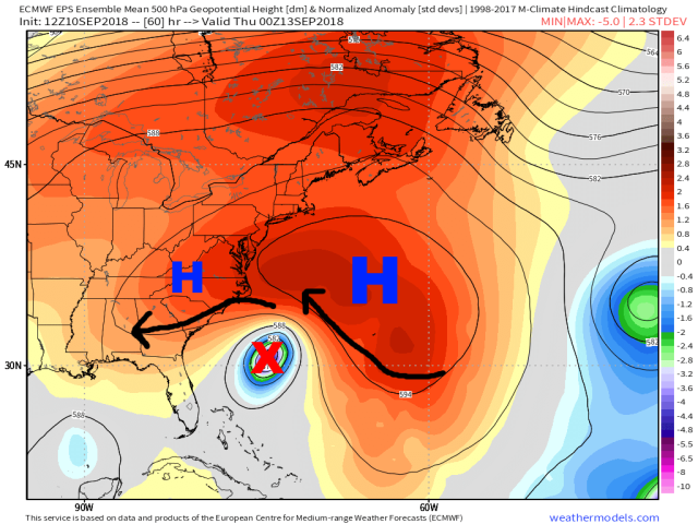
European ensemble mean 500mb pattern valid Wednesday evening
Through Wednesday evening the steering mechanisms remain fairly straight-forward. The ridge to the north/northeast of Florence will remain dominant, at this point imparting a northwest motion on the hurricane. A weaker lobe of the ridge over the southeast (with no true break between the two) will impart a west or even southwesterly motion. The ridge to the east being dominant will likely result in a net WNW to NW motion at this point.
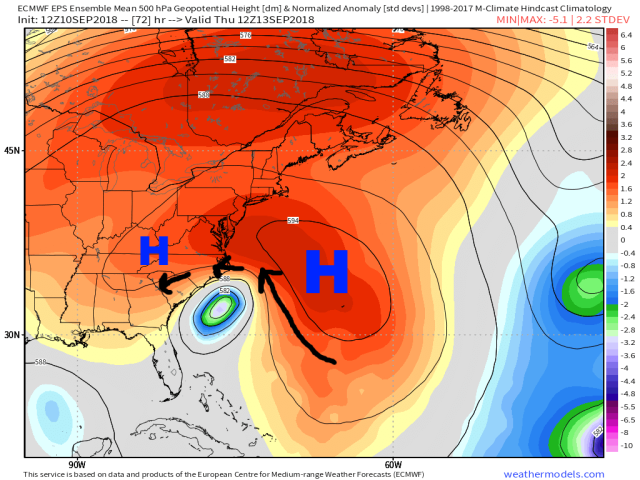
European ensemble mean 500mb pattern valid Thursday morning
By Thursday morning the ridge to the northeast of Florence is beginning to weaken some, but there’s still no real break in the ridging in front of the storm, with a weaker ridge over the Appalachians still imparting if anything a modest west/southwest component of motion. This should still result in a continued WNW to NW motion into Thursday, with perhaps the slowing beginning around this point late Wednesday night/Thursday morning as the ridge to the northeast starts weakening some.
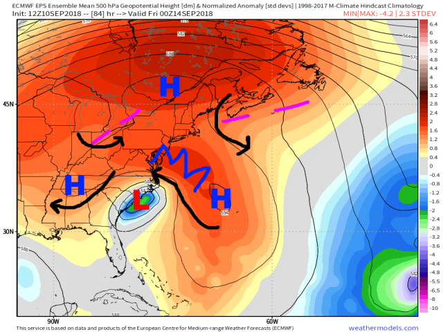
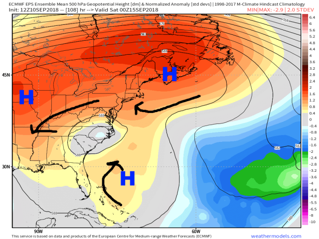
European ensemble mean 500mb pattern valid Thursday evening
By Thursday evening as Florence makes its likely Carolinas landfall, the ridge to the east/northeast continues to sag south and weaken a bit, with the ridge to the west/northwest of the hurricane remaining in place. There are a couple of weak shortwave troughs in the flow, but they’re weak and aren’t close enough to the hurricane at this point on the European ensembles to disrupt the steering from the ridges in the vicinity of the eastern U.S. and western Atlantic. The trough over Nova Scotia dropping S/SW at this point is something that could push Florence south/southeast away from the coast, but only if the hurricane ends up tracking on the right side of guidance towards or just east of the Outer Banks.
At this point, the Euro suite has Florence nearly equidistant to the two ridges, does not have a break in the ridging north of Florence, and is still somewhat stronger with the ridging to the east/northeast. This would cause a somewhat slower but still WNW motion to continue through landfall, with the steering weakening further after landfall.
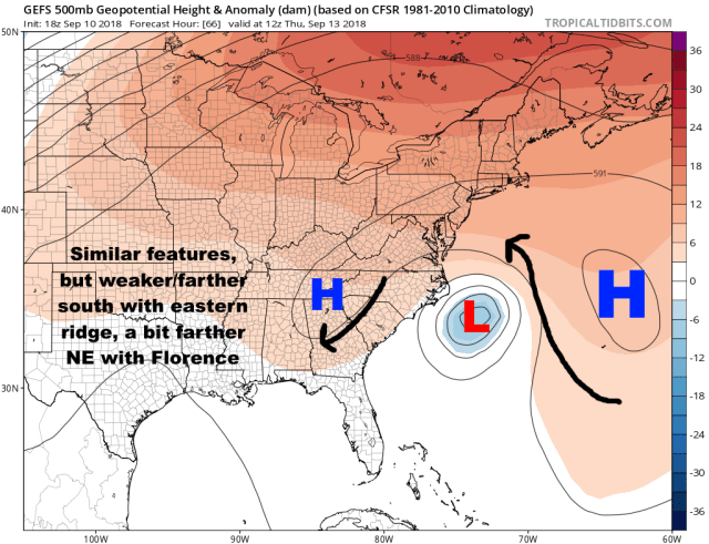
GFS ensemble mean 500mb pattern valid Thursday morning
The GFS suite remains to the “right” of the European suite in general today. The GFS is weakening and shifting the western Atlantic ridge farther south quickly, and turns Florence north a bit quicker, allowing more of a northerly motion to be imparted before the model and its ensembles also collapse the steering currents later Thursday into Friday, causing it to stall in the vicinity of the NC coastline (perhaps just off/east). This track also gives more of an opportunity for the small shortwave dropping in from the northeast (which doesn’t show up well on the GEFS mean image above) to give Florence a small nudge away from the coast, which causes many GEFS members to stall just offshore.
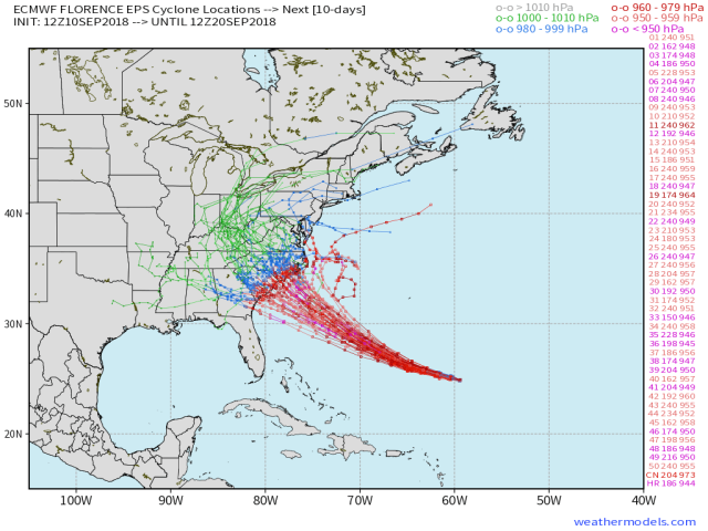
European ensemble member forecast tracks
The European ensemble members, given their evolution of the pattern discussed above, remain generally set on a landfall in the Carolinas Thursday afternoon or evening. A few members (it’s about 3/51) do manage to stall it just east of North Carolina, and several members are as far southwest as Georgia. But as has been the case for a number of runs, the bulk are focusing on the Carolinas.
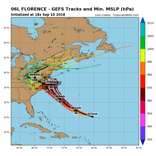
GFS ensemble member forecast tracks
The GFS members, due to the slightly different evolution discussed above, are generally right of the Euro ensembles. Roughly half the members still plow it right into NC, though pretty much the other half stall it just offshore to the east or southeast. From there the members are a mess due to the breakdown in steering currents, and many members eventually drift it back west this run after stalling it offshore.
European ensemble mean 500mb pattern valid Friday evening
As we head into Friday and the weekend, the steering currents really do break down some more as the strong ridge to the northeast of Florence weakens considerably. There will be a few varying areas of ridging steering Florence weakly, with a few other small, embedded shortwaves that won’t be modelled well at this range that may also have a considerable influence on Florence’s exact motion:
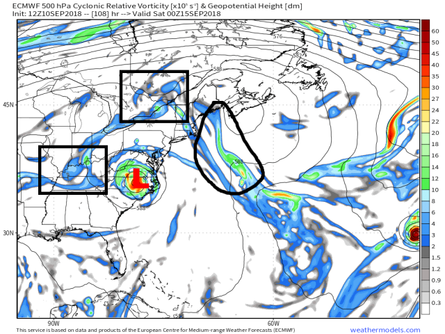
European model forecast 500mb height and vorticity valid Friday evening
This all likely means that Florence’s motion will be slow and erratic from somewhere around Thursday night or Friday morning until a more substantial shortwave can kick it east. It could drift towards the Mid Atlantic or Ohio Valley, or could meander around the Southeast. It’s too early to say for sure. I will say that with all of the unusual ridging north of the storm that I’d be careful to expect significant northward movement, though perhaps it eventually drifts up there.
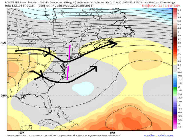
European ensemble mean 500mb pattern valid Wednesday 9/19
Unfortunately, the ridging doesn’t break down enough for a more substantial shortwave to come in and push Florence east until somewhere around Tuesday or Wednesday…so wherever it’s drifting, it will be doing so for a while.
My ultimate thoughts here are that the European suite has been leading the way the entire time with this storm…from missing the initial recurve opportunity last weekend to honing in on a US landfall while many other models were still taking it to the east…and the ensembles have been very insistent on a Carolinas hit for the last 3 days while other guidance continues to waiver. The European ensemble is the guidance to beat historically, has the hot hand, and seems locked in.
Because the steering currents do fall apart right around the likely landfall…with some questions regarding the shortwave coming around the ridge from the northern Atlantic that could induce a “tug” away from the coast at the last second…a landfall in the Carolinas can’t truly be “locked in” with 100% certainty yet (but I’d say it’s about 90-95% right now). There is still some level of uncertainty here, but not nearly enough to stop preparations for a major hurricane landfall.
With the dominant steering ridge to the north/northeast of Florence appearing to remain dominant through Thursday, even if it starts weakening some on Thursday, and no other strong mechanisms to steer Florence, the inertia argument seems to make sense to me…the storm may begin slowing on its approach, but it’ll ultimately keep going WNW to NW into the Carolinas Thursday afternoon or evening because there’s nothing to really stop it. That’s what I’m expecting. The one fly in the ointment that could result in an actual “push” away from land (as opposed to just a slowing of the forward speed) would be the shortwave to the northeast of the storm being close enough to actual have any influence…but that shortwave is going to be fairly weak, and unless the storm tracks farther to the right over the next 48 hours, it will probably be too far away to feel any influence from it. It’s also important to note that Florence itself is intensifying that ridge to its north due to all of its anticyclonic outflow and latent heat release, which also kind of argues against a farther right track. I tend to favor a landfall somewhere in North Carolina, probably just east of the South Carolina boarder, but a small left shift is all that would be needed to get a landfall in South Carolina, and it’s way too early to rule that out.
With Florence slowing considerably as it comes in and potentially drifting around for several days after landfall, severe freshwater flooding is a real concern. Florence already has a large area of hurricane-force winds, and will likely increase in size further due to an eventual eyewall cycle. This will cause damaging winds to affect a large area when it makes landfall with a significant storm surge along and to the right of the center as well. Although Florence will spin down as it moves inland, its large size may allow strong enough wind gusts to topple trees and knock out power to occur well inland…especially if the Euro’s faster speed pans out and this gets all the way to the Appalachians…where the terrain would certainly cause locally enhanced winds and hence wind damage. All told, this adds up to a severe impact to the Carolinas if it comes to fruition, near the upper-end of what they’ve seen before. This is a serious situation, and hopefully people do what they can to protect their lives and get out of harm’s way. Flooding rains could get as far north as parts of the Mid Atlantic and maybe even the upper Ohio Valley as well, though the evolution that far into the future is far from certain yet.
