
A few quick thoughts here on the next 3ish weeks.
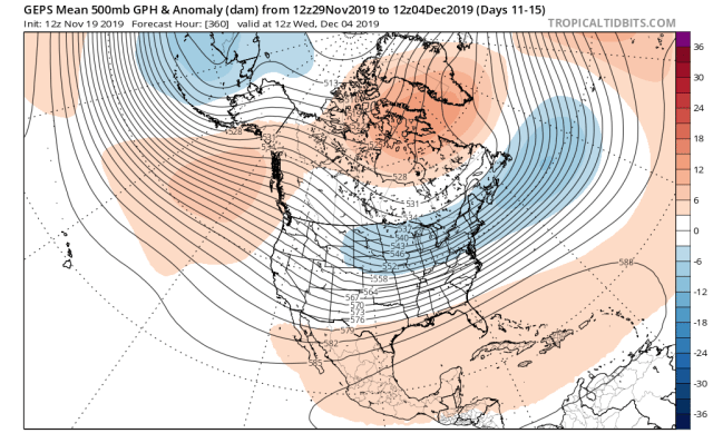
After a pre-Thanksgiving cutter that will bring a warm-up to the Eastern U.S., what happens to open December seems to be up for debate. The ensembles agree on the potential for a legitimate, retrograding -NAO. While the attached images are pretty far out and the NAO is finicky, the initial block develops within the next several days and is of pretty high confidence to occur…the question is, how long does it maintain? There is more significant disagreement on the Pacific side, with the EPS developing a -PNA/+EPO, while the GEPS and GEFS have a more negative EPO and neutral to somewhat positive PNA:


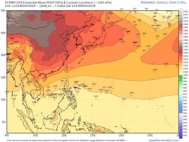
There are a number of arguments to support the EPS’s -PNA/+EPO combo that would scour out the eastern U.S. cold as soon as the -NAO went away…in week 1, the combination of a negative East Asian Mountain Torque (note the anomalously low pressure over southeastern Asia), strong Indian Ocean forcing, and lack of Pacific forcing suggest a retracted Pacific jet and Aleutian ridging (a -PNA):


And not only that, but as has been pretty well-established by others on boards and on Twitter recently, a phase 1 MJO (western Indian Ocean forcing) does correlate to a -PNA/+EPO and ultimately, eastern U.S. ridging…the two images attached are the Paul Roundy tool which takes into account analogs that match the low-frequency forcing, and the other is the CPC lagged phase 1 composites (lags 0, 1, 2, and 3 pertinent for the next two weeks):


So, plenty of evidence supports the EPS idea of a poor Pacific pattern being in place to start December (though it’s worth noting the -NAO would result in a non-zero wintry threat with that pattern for the eastern U.S., especially inland where it doesn’t take that much cold to snow in DECEMBER). It’s especially damning that the forcing remains in the western Indian Ocean for the foreseeable future once it gets there.
But, as you likely have realized by now I rarely post when the news is all bad, because I’m a complete and total snow weenie (despite how busy it gets at work when it snows). So, what’s the up-shot here? Well, it’s obviously the North American contingent of ensembles. How do they pull off that Pacific pattern, and is it realistic?

There is good agreement (and has been for a while) on a positive East Asian Mountain Torque occurring week 2 into week 3…the EPS (and the GEFS) has also been signaling some potential for a typhoon later in week 2 over the western Pacific. The +EAMT seems very likely to occur, but we’ll see about the typhoon at this junture. Either way, one or both would suggest the Pacific jet intensifying and trying to amp ridging into Alaska again…it’d also likely suggest a more neutral or even somewhat positive PNA and more negative EPO, especially if we get a typhoon feeding into the Pacific jet as a +EAMT occurs. If we amp the Pacific ridging again, although the cold likely would dump into the western or central U.S. initially, the -NAO would allow it to get into the east with no problem. If we don’t amp the Pacific ridging (so more like the EPS) it’s a closer to average pattern; the NAO keeps the eastern U.S. cooler than it would otherwise be, but the air is more Pacific than Arctic in origin with the EPS pattern. My gut is we do try to amp the Pacific ridging again to start December as the +EAMT and possible tropical cyclone suggest it, and we’ve amped that ridging whenever possible this fall. However, we’ll see if it’s closer to the GEPS/GEFS or more a compromise between that idea and the EPS (which wouldn’t be as cold). Regardless, if the the -NAO verified to start December it would suggest some snow potential for the eastern U.S.
Briefly moving ahead, I do think the persistent western Indian Ocean forcing eventually dominates and the eastern U.S. warms up…my guess is it happens at some point by mid-December. Once that happens I think we’re pretty mild for at least 2-3 weeks, and despite the interesting look we have to open December, I think it’s decently likely much of the eastern and central U.S. finish the month of December with a positive anomaly for temperatures. Exactly how warm the monthly departures are will be modulated by how the month starts, so a GEFS/GEPS outcome (colder start that takes longer to scour out) would temper the monthly warmth a good bit compared to the EPS (which I think is too mild to start the month, but may point to how the pattern inevitably ends up at some point).
