
This is going to be a long post discussing my analogs that I finally got around to updating along with how the next several weeks may play out…and attempting to tie those things together.
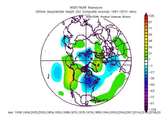
We’ll start with the analogs…after weighing a number of variables from tropical and extra-tropical SSTs, the solar cycle, QBO, low-frequency pattern in the tropics this fall and the general hemispheric pattern this fall, the larger set of analogs is:
1953-54, 1958-59, 1967-68, 1969-70, 1977-78, 1978-79, 1987-88, 1993-94, 1995-96, 2002-03, 2003-04, 2004-05, 2006-07, 2013-14, 2014-15, 2017-18, 2018-19
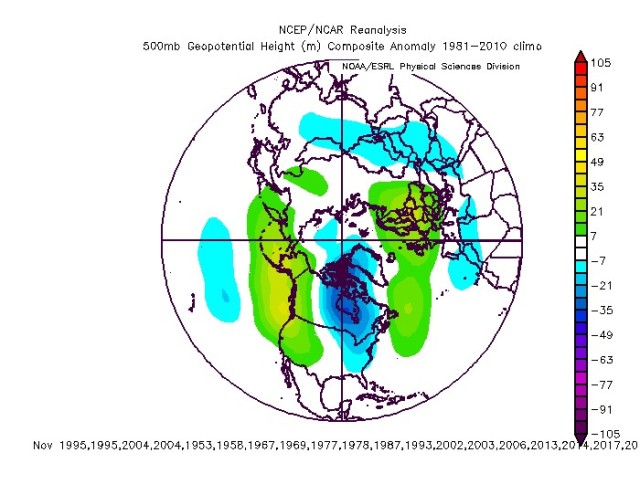
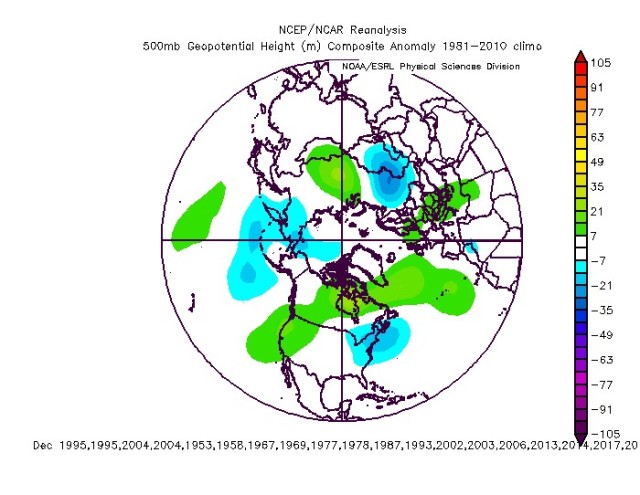
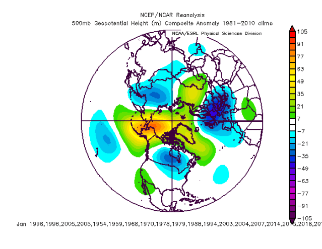
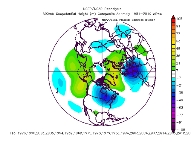
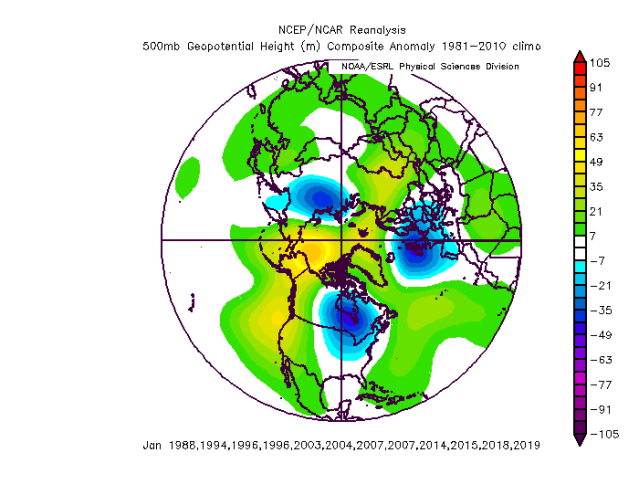
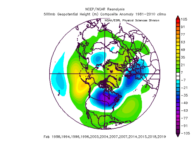
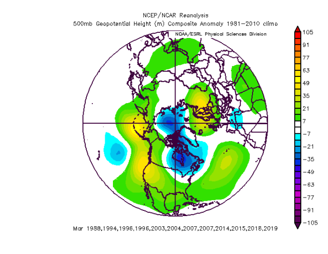
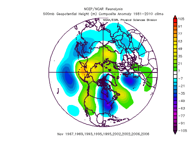
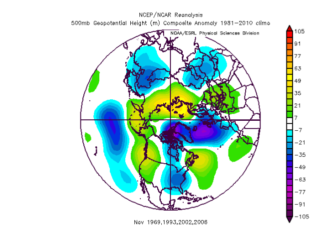
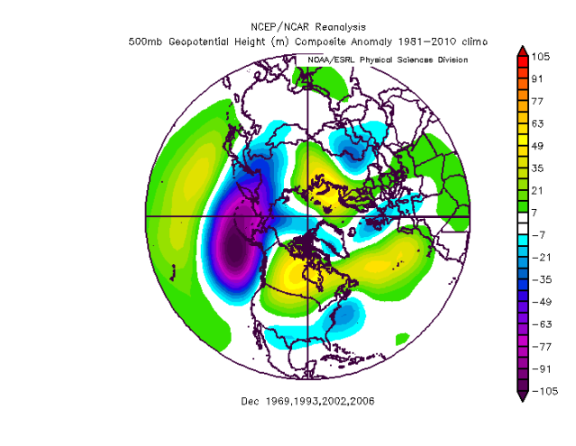
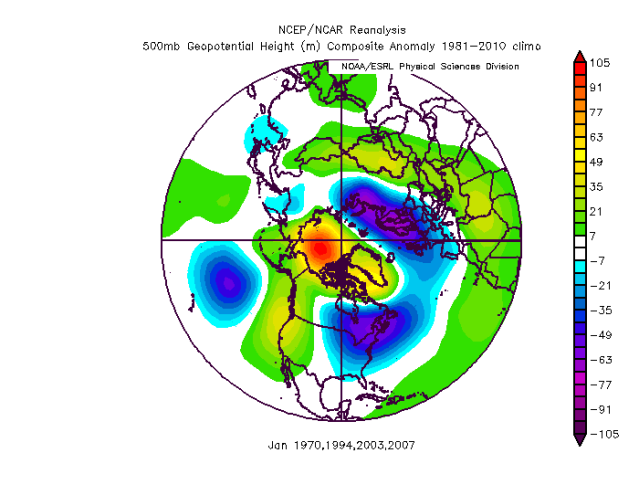
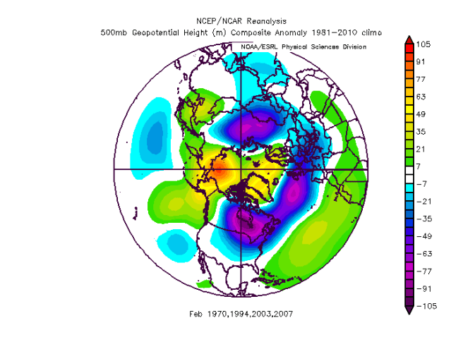
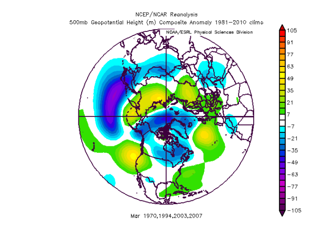
Here are the Nov-March 500mb composites:
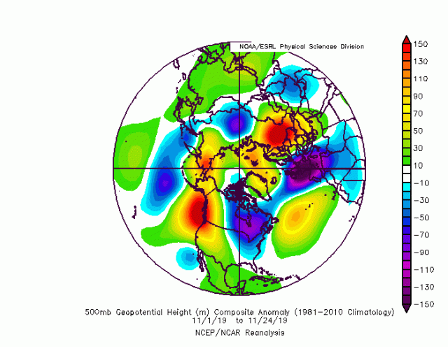
For comparison, here is this November so far:
Before diving in a bit more and analyzing features this month/trying to tie in to this year, I ran only certain sets of the analogs (based on factors such as QBO, low-frequency forcing in the fall, northern hemispheric fall pattern, and the stratosphere) and found some of them yielded a somewhat better representation of the November and likely December pattern than the full set (not that the full set is bad for November, it’s not)…I’ll post a couple of the more intriguing sets…
The closest set in November/perhaps December, likely not coincidentally, is the set where I only take years in the analog set that at least somewhat match this fall’s pattern…here’s those monthly 500mb composites:
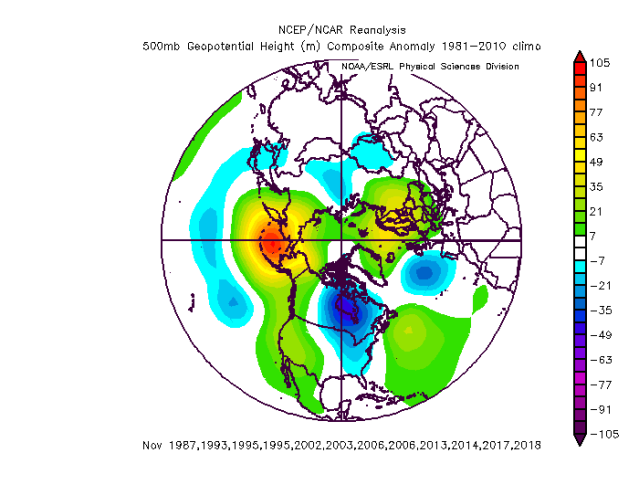
Here are the analogs with at least somewhat similar fall low-frequency forcing and QBO to this year:
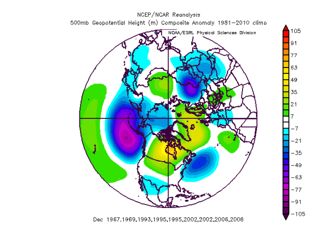
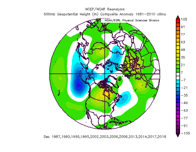
And to round out, the four analogs that had fairly perturbed stratospheric PV’s in December with at least some QBO similarity to this year:
I toyed with several other things, but I don’t want to post anymore analog 500mb composites right now and you likely don’t want to look at them, so I’ll stop. A few takeaways are:
- Various composites do capture this month’s pattern respectably well
- Although a weak signal among the entire set, the various “enhancements” definitely strengthen the strong Aleutian low and generally warm North America look in December with a neutral to positive AO, and that look is quickly emerging on the EPS as we head into December after a chilly start. This is a strong signal for a mild December on the analogs for much of the continent.
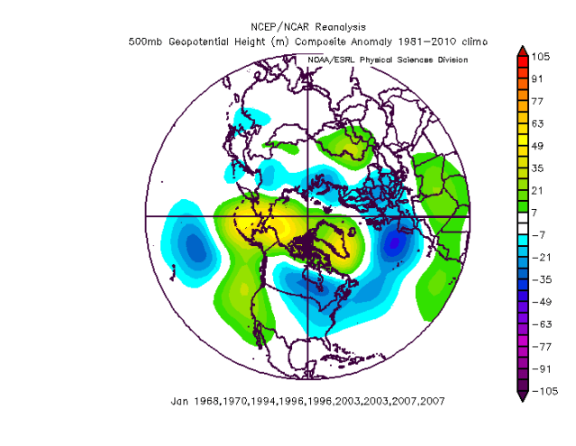
- January shows a strong blocking signal in all composites, with –EPO blocking strongest with a decent –NAO signal too.
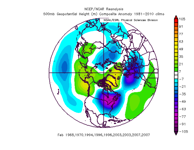
- February has the strongest –NAO signal in general, and is absolutely brutal for the Midwest and Northeast in terms of temperature anomalies on nearly every composite I did.
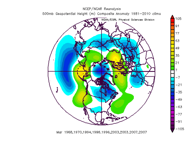
- March is not signaled to be particularly warm in any of the composites, though the QBO/December stratosphere set is not quite as chilly as some of the other sets.
So, tying everything into the pattern we have now and may see in December…
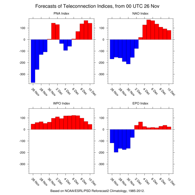
The start of December will likely be chilly for the central and eastern U.S. as a transitioning NAO, EPO-induced cold, and PNA spike work together to force cold into most of the CONUS. However, the traditional teleconnections above quickly revert to opposite phases that are not supportive for cold as the AO also goes moderately to strongly positive in early December. This suggests that the cold pattern to start December will moderate quickly, likely by the second week of the month. A number of factors, aside from ensemble teleconnections, support this warm-up…
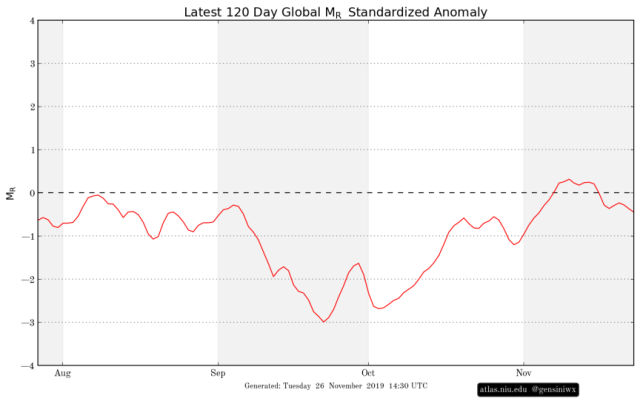
Trying first to look at the GWO, week one does feature a few sources trying to add momentum…a strong East Asian Mountain Torque, some Rocky Mountain Torque, and active western Pacific convection/tropical cyclone activity. This will likely cause the GWO to rise modestly from its current weak negative value:
However, week 2 sees the East Asian Mountain Torque weaken quite a bit while we lose frictional torque as pressures rise over the Equatorial Pacific, with at best weak positive Rocky Mountain torque. We do gain some frictional torque back in week 3 if the models are right in some convection/lower pressure starting to return to the western/central Pacific, though the mountain torques are both progged to be strongly negative. The EPS guidance is similar to the CFS in all of these areas, except it loses the +RMT quicker in week 2:

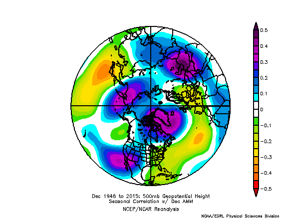
A general lack of momentum would argue for a less blocky high-latitude pattern, along with a weaker/more retracted Asian-Pacific jet and mid-latitude ridging over the Pacific, likely putting troughing near the West Coast. For reference, here is the December correlation to AAM, with the color table reversed to depict what the correlation is when the AAM is negative:
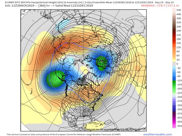
Some similarities to the pattern showing up later in the EPS runs, with a generally +AO, +NAO, and mid-latitude ridges over the western/central Pacific and across much of the Atlantic.
My general thought is that the sources of momentum that we should see over the next 7-10 days support the generally amplified pattern, and that the +EAMT through week 2 does support the +PNA that the ensembles re-develop during week 2 that would linger into week 3. This added momentum would also support disruptions to the stratospheric PV. However, there will be a clear loss of momentum most of weeks 2-3, which supports a generally +AO and poor Pacific pattern when combined with other factors.
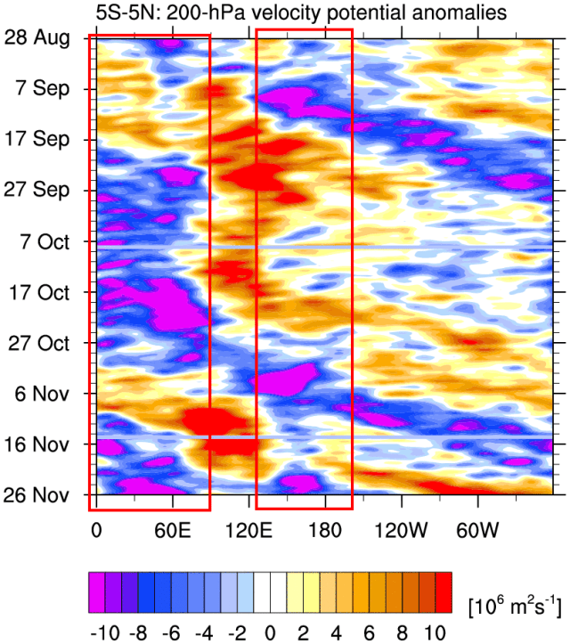
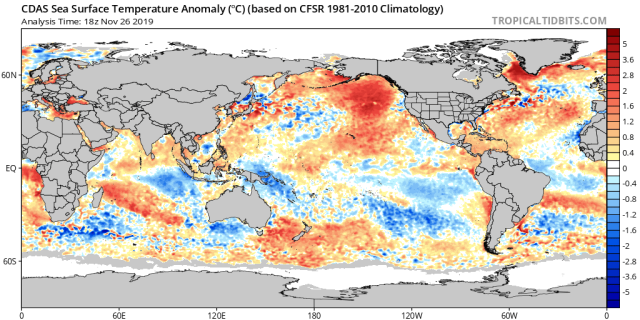
Tropical forcing over the past few months has been dominated by a strong positive Indian Ocean Dipole, with essentially a standing wave over Africa and the western Indian Ocean. The strong, displaced West Pacific warm pool has been somewhat active near and west of the Dateline, with frequent, strong subsidence in between in the vicinity of Indonesia. Note that the AAM was at its lowest during the second half of September and first half of October when convection subsidence dominated much of the Pacific.
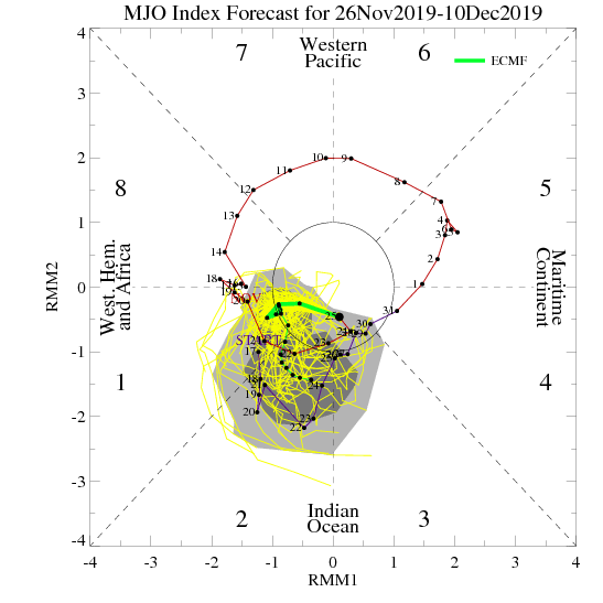
After a strong MJO propagation in early-mid November, the MJO has slowed considerably over the western Indian Ocean as it ran into the standing wave/enhanced lift that’s been there all fall due to the strong +IOD. While a phase 2 MJO is not necessarily bad in the short term, it usually turns warm shortly after in December:
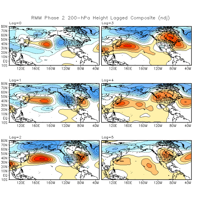
Each lag is roughly 5 days…note how with time, after a phase 2 RMM (which we’ve had for the last week or so and will have for another week or so), the pattern trends awfully close to what the EPS is showing developing within 2 weeks; a strong Aleutian low with troughing into the western US, a +AO, and anomalous mid-latitude ridges over the Pacific and Atlantic, and is not too different in some of the lags than the December pattern in a number of the “enhanced” analog packages.
In addition, Paul Roundy’s tool that incorporates the low-frequency forcing shows a similar pattern for a phase 2 MJO to what is likely for a time 10-15 days from now, and is an absolute torch in phase 3 (which is where some guidance tries taking it towards mid-December):
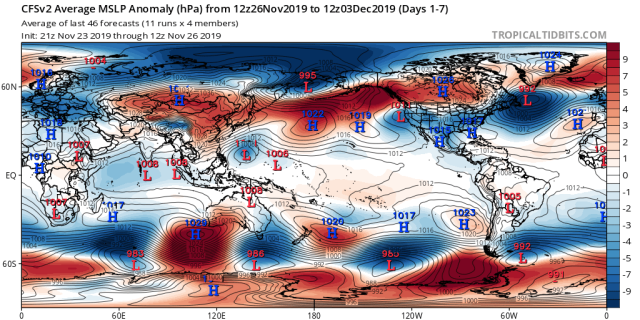
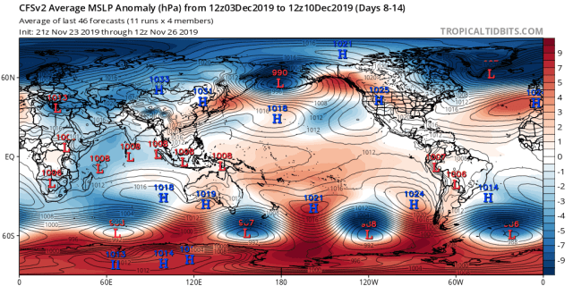
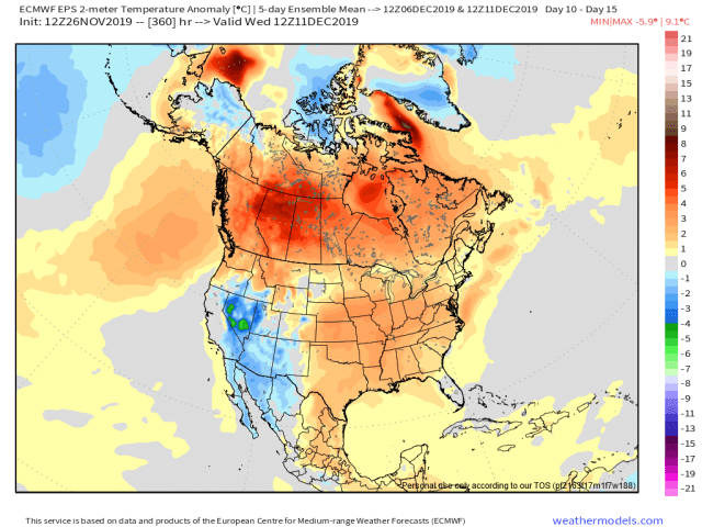
So, between analogs, ensembles, GWO, and tropical forcing, a number of factors argue for a +AO, lack of blocking, and unfavorable Pacific pattern taking hold in December. Although the chilly start is very likely, it doesn’t last long, and the warm signal thereafter is very strong. Note how the EPS, despite having a +PNA, generally is very mild at 2m at the end of its 12z Tuesday run:
Now, despite the very strong (in my opinion) warm signal for a large chunk of December, there are some positive developments from above…
The added momentum from the mountain torques during the next 7-10 days, along with a subsequent strong Aleutian low, are favorable for disruptions to the stratospheric PV (in particular via wave 1 fluxes). The GEFS and ECM both show very strong wave 1 activity ongoing now, and the GEFS suggests another surge towards mid-December (and the EPS pattern may allow for it).
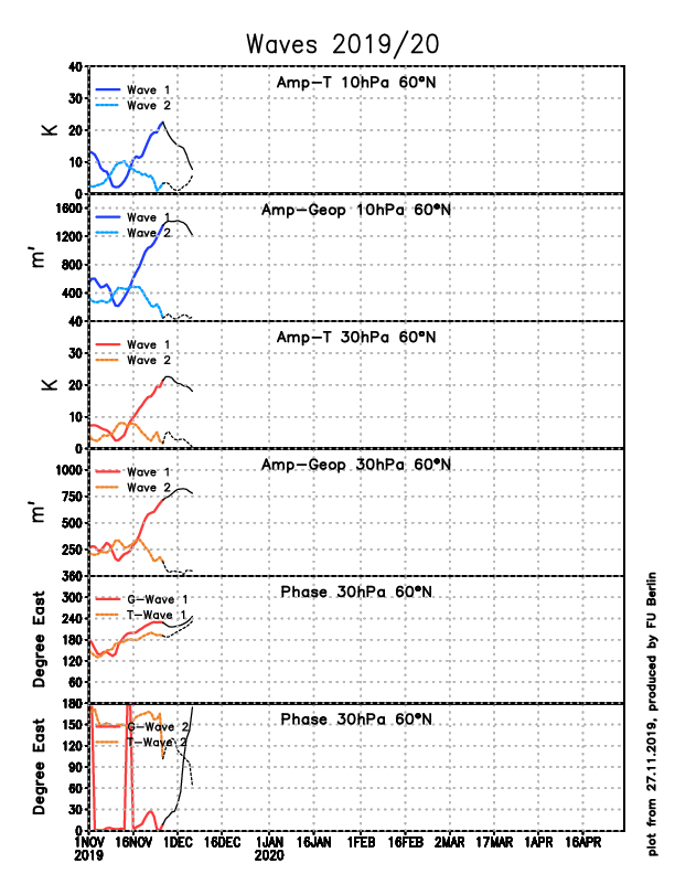
It’s unclear whether or not this will cause a major Sudden Stratospheric Warming or not…while we have recently seen a minor warming, and another at least minor event is likely during the first half of December, only the extended range GEFS has been actually breaking down the polar vortex, while the op Euro, which only goes out to 10 days, has not yet shown this at 10mb. While the vortex will likely be weaker than climo in December, whether or not we pull off a major SSW event or not is still very much up in the air. That said, the PV will be fairly disrupted, and any downwelling for the upcoming disruption during week 2 would occur later in December into early January.
Attempting to tie the tropical forcing, GWO, stratosphere and analogs all back together now, here we go…
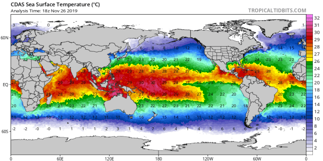
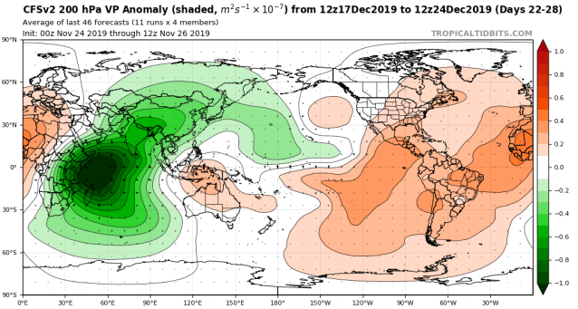
The stratospheric warming events will keep the tropical stratosphere anomalously cold for the foreseeable future, which should lead to enhanced tropical forcing. The Western Pacific warm pool is somewhat warmer than normal displaced east towards the central Pacific:
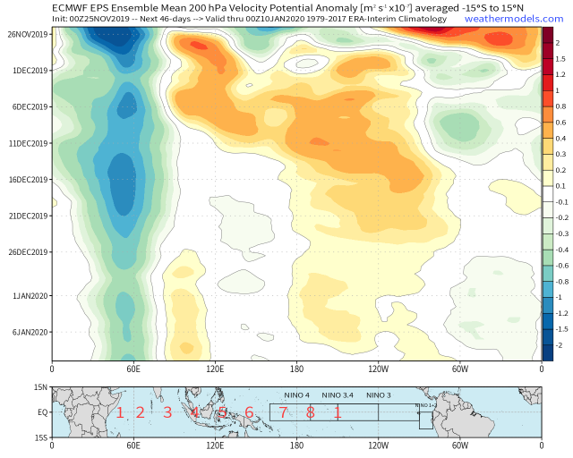
This does argue for continued convection over the western and central Pacific, and the EPS weeklies and CFS both show that resuming mid-late December:
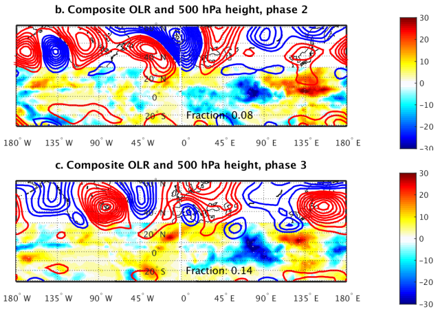
Although the eastern Indian Ocean and western Pacific are vaunted as the so-called “warm phases” of the MJO (and, at T=0 they do correlate to warmth for most of the CONUS), unlike phase 2, their lagged composites get considerably better with time. So really, we do want the MJO to come out of the eastern Indian Ocean and propagate at some point in mid-late December…the improvements at later lags become apparent as early as phase 4, and improve through phase 8 for NDJ…I’ll post phases 4 and 8:
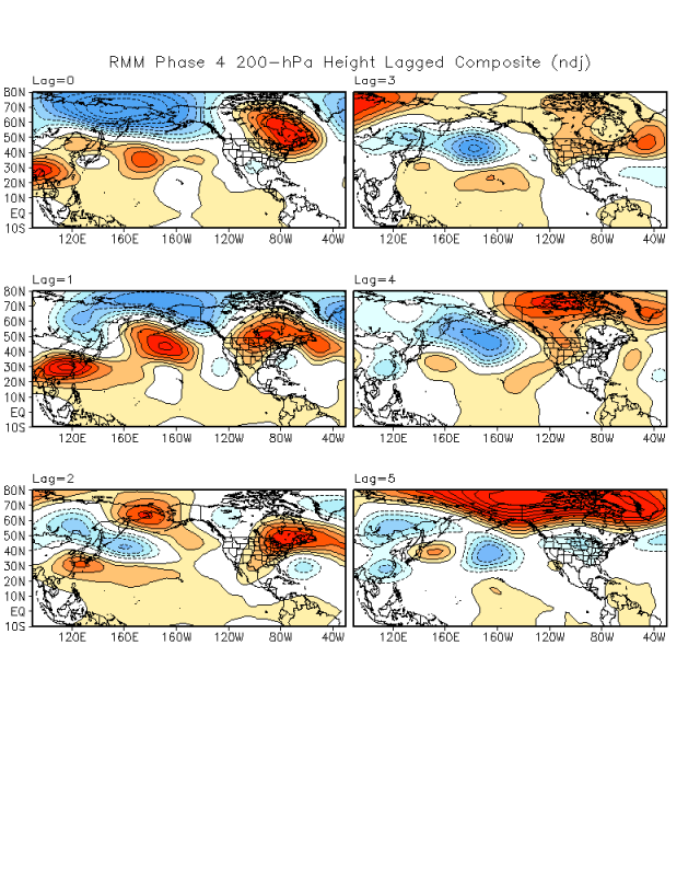
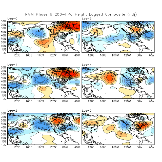
Given the cold stratosphere and general (albeit weaker) lower frequency forcing over the Pacific this fall, it seems likely we see another MJO propagation at some point. Based on the EPS and CFS, that could happen at some point mid-late December. The subsidence over Indonesia would suppress the MJO in phases 3-5, though the MJO would hopefully still progress through those phases and through the western Pacific, as the eventual result of that is a better pattern than what we’re seeing.
The GWO, after what may be a period of moderately negative values in mid-December, will likely climb later in December when/if convection returns to the western and central Pacific. There are also some signs on the EPS weeklies and CFS that the –EAMT will weaken, and perhaps even become positive, in late December/early January. This would also add momentum and support a more amplified Pacific pattern. This would all occur in the general vicinity of when any stratospheric warming events in early December would try to downwell, and when the analogs all strongly suggest blocking becomes more likely in January.
So, while I think evidence is strong for a mild, if not full-blown “warm” period for a good chunk of December, I do think that if we see the MJO cooperate (propagate east by late December), along with at least a minor stratospheric warming event during the first half of December, that the factors would try to align at some point during the first half of January. The type of pattern in late December, should the MJO propagate, may support further stratospheric PV disruptions should any warmings over the next couple of weeks remain minor. The analogs are then very favorable through February for the eastern U.S., and don’t suggest a March torch either.
After all that, the tl;dr version is:
- I think, with much more confidence than several days ago, that December winds up mild for much of the U.S., though there will be cold weather with snow potential to start the month, and I don’t want to rule out some improvement to the pattern towards the end of the month
- Analogs strongly point to increased blocking in January, and I believe that if the (seemingly likely) upcoming at-least-minor stratospheric warming event does in fact occur, and the MJO is able to propagate east within the next few weeks, that this year would not be an exception
- Per the analogs, once it gets blocky in January it can stay quite cold through February and perhaps into March. This is seemingly supported by the QBO becoming more favorable for blocking through the winter, and by us likely becoming (in my opinion) farther removed from the very low AAM/GWO state we saw earlier in the fall.
