
With a NE Ohio focus…
Suppose I should post this before it starts snowing…
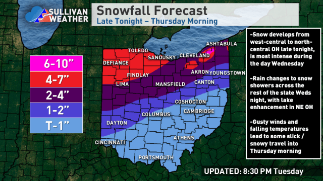
With the 850mb low track still near or just west of Sandusky into western Lake Erie, expect the heaviest synoptic snows to fall in NW Ohio. There, a long duration light snow from tonight (Tuesday night) through Wednesday evening, along with a period of moderate snow Wednesday afternoon when some modest fgen and deform ramp up will likely lead to a widespread 4 to locally 7″. The rain/snow line will slowly progress southeast during the day, with the west side changing over by early-mid afternoon, and Cleveland and the Snowbelt late-afternoon or early evening.
In north-central and NE Ohio there will be less synoptic snow as the weak deform band quickly swings through, thinking the synoptic snow is 1-2 or 3″ in Cleveland/Akron and 2-4″ on the west side…generally, the synoptic snow will be heavier closer to the lake as the best lift passes to the north. I do like the lake enhanced setup…temperatures get cold enough for lake enhancement from west to east between 8-10 PM and are quite optimal for several hours overnight with a NW flow backing towards WNW, with 700mb moisture not stripping away Cleveland points east until close to sunrise Thursday. Usually when the lake induced instability gets above the -10C level (which occurs late-evening) there will be moderate to heavy orographic lift snow in these setups in the terrain downwind of the lake until the 700mb moisture strips away. This gives a prolonged window from late evening through around sunrise Thursday of good lake enhanced snow east of Cleveland (tapers off slightly quicker south of Cleveland).
My general rules of thumb in these lake enhanced scenarios (when it’s cold enough, which it will be by late evening) are to take the highest QPF and assume at least a 15:1 ratio. Some hi-res models have up to half an inch of QPF as lake enhanced snow through Thursday morning, which yields potentially over half a foot. Another rule is that once it gets cold enough that rates in the higher terrain will be generally 0.5-1″ per hour until the 700mb moisture strips away…given the duration (on top of the light synoptic snow in the early-mid evening) this also suggests over half a foot of lake enhancement in the prone spots.
I’d like to see the hi-res stuff just a little juicier for widespread 6″+ totals, but think anyone in the hills south or east of Cleveland gets 4-7″, with 6″+ being likely in the highest terrain of Geauga (and also NW PA) through Thursday morning. With wind gusts of 25-35 mph and an increasingly fluffy snow overnight, there will be blowing and drifting snow and it will be quite wintry by Thursday morning. There will be much less lake enhanced snow near the lakeshore and I’d expect the immediate lakeshore to come in on the low ends of the ranges across the board…worried about the western lakeshore missing the better synoptic snow to the west and better lake enhanced snow to to the east, so we’ll see if those 4″ totals can be met in northern Erie County. Otherwise, I think the terrain does fine.

In terms of the additional lake effect, conditions quickly become favorable for traditional lake effect Thursday morning and afternoon, though winds go westerly (maybe even slightly S of W at times) by late Thursday through the day Friday. The lake effect will likely be moderate and accumulate efficiently Thursday afternoon into Friday morning with a long fetch and little shear, good lift and moisture in the DGZ, good synoptic support from a vort max rotating around the closed low to our northeast, and the edge of the synoptic moisture grazing Lake Erie…but, I think the heaviest snows in this period are focused near or just north of the 322 corridor in the northern Snowbelt into NW PA with a more westerly flow. Given the duration of this setup and likely high ratios, where bands persist could see another 6-10″ of snow Thursday afternoon through Friday morning.
There may be a lull Friday afternoon as we briefly get into some synoptic-scale sinking motion, but conditions become favorable again Friday night into Saturday morning. A lobe of deep moisture and a good vort max move through, with winds slowly shifting from W to NW. I think this is more of a lake enhanced setup with weaker instability but abundant moisture and some lift, but good snow growth given the temperature profiles. Winds will favor broad convergence over the Cleveland area and Snowbelt which will help focus snow, and orographic lift will help too. Given the decent duration and likely good ratios, this likely supports another 4-8″ type accumulation from eastern Cuyahoga County into southern Lake, most of Geauga, inland Ashtabula and the higher terrain in NW PA Friday night into Saturday morning. Some accumulations likely get into the secondary Snowbelt south of Cleveland by Saturday morning as winds go more NW.
The lake effect likely winds down on Saturday as ridging builds in…time permitting I’ll post a map for just the lake effect Thursday afternoon-Saturday on Wednesday.
