
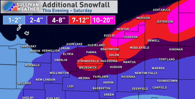
I drew this map around 5 PM and this incorporates snow after that, so a bit of this has already fallen.
Some reasoning:
My thoughts on tonight haven’t changed much…the synoptic snow this evening is not that heavy or efficient, but may drop up to an inch or two in the Cleveland area and east side. Lake enhancement ramps up starting 9 or 10 PM and is most intense about 11 PM – 6 AM east of Cleveland, tapering slightly faster in the Cleveland area and secondary Snowbelt (and lingering past sunrise in NW PA). I still think the duration of the lake enhanced snow and improving ratios will allow for 4-6″ in the hills of the secondary Snowbelt by morning (when including the ongoing synoptic snow) and 4-7″ for most of the higher terrain east of Cleveland, with 6″+ likely in northern Geauga County and most of interior NW PA. Hi-res models continue to have 0.4-0.5″ of QPF as snow in the higher terrain by morning which supports the potential for 6″+ in the most favored hills with improving ratios overnight. Winds ramp up overnight as the ratios improve so it could be a pretty wintry scene by morning. It will likely only be 2 or 3″ tonight closer to the lake and in Cleveland proper, dropping off towards Sandusky where most of their snow was from the synoptic snow today with lighter snow from here on out. With a strong NW flow 2″+ totals tonight likely make it down to Mansfield, Akron and near Youngstown.
There’s likely a bit of a lull Thursday morning, though lake effect conditions become passable in the afternoon. Bands are likely disorganized Thursday afternoon but may drop a Coating to 2″ as they go, and may start southwest of Cleveland and in the secondary Snowbelt before shifting into the primary Snowbelt towards evening. Thursday evening through Friday morning is interesting as a surface trough and vort max move through slowly, adding lift. The edge of the better synoptic moisture just grazes NE Ohio, though with a long fetch and some Lake Michigan moisture should be sufficient. Although instability and moisture both are marginal to moderate, they are well focused in the DGZ Thursday night into Friday morning, so ratios will be good. In terms of band placement, NAM guidance has a band well southwest of Cleveland Thursday evening but the RGEM lifts it into the primary Snowbelt quicker…given the westerly flow, I heavily favor the RGEM, with a few W-E oriented bands likely from northeast Cuyahoga, Geauga and Lake through NW PA and SW NY. Given the good ratios, long fetch, and synoptic lift for a pretty long period of time I expect these bands to drop 3-6 or 4-8″ type amounts Thursday evening through Friday morning on parts of the primary NE Ohio Snowbelt into NW PA and SW NY. There will be little south of Cleveland, though some snow showers and the synoptic lift could produce a local coating to 1″ in the rest of NE Ohio in this window (though nothing organized outside of the primary Snowbelt).
There’s likely a relative lull later Friday morning into the afternoon, before a fairly deep lobe of synoptic moisture and embedded shortwave drop across Lake Erie Friday night into Saturday morning. As winds slowly shift from W to NW over the lake convergence will increase over the Snowbelt and there will be some upslope, with snow spreading south into the Cleveland area and eventually perhaps the secondary Snowbelt south of Cleveland again. Ratios again look high with a decent amount of moisture and some synoptic lift, so I think another few to locally several inches can occur Friday night into Saturday, most in the higher terrain east of Cleveland into NW PA and SW NY, but also with some snow for the Cleveland area and secondary Snowbelt.
Given the multiple windows for snow and ratios, I think a widespread 10″+ is likely for the hills in the primary NE Ohio Snowbelt into NW PA, with 15-20″ where bands are especially persistent. The Cleveland area and lakeshore will see less, but occasional periods of snow will gradually add up some. The secondary Snowbelt I’m debating if I went a bit too high, but if they get a few inches tonight, a little bit Thursday afternoon, and a couple inches or so Friday night into Saturday can squeak out the low end. Most of the snow west of Lorain and south of Medina, Akron and Youngstown will fall tonight, though they may see some snow showers at times Thursday through Saturday that can add additional light amounts.
