
There have already been almost too many wintry systems across the central and eastern U.S. since late January to keep track of, including a 20-30”+ whopper of a storm where I’m living in northern New Jersey. And for better or worse, there are three more impactful systems clearly signaled by operational and ensemble guidance between this weekend and the end of next week.
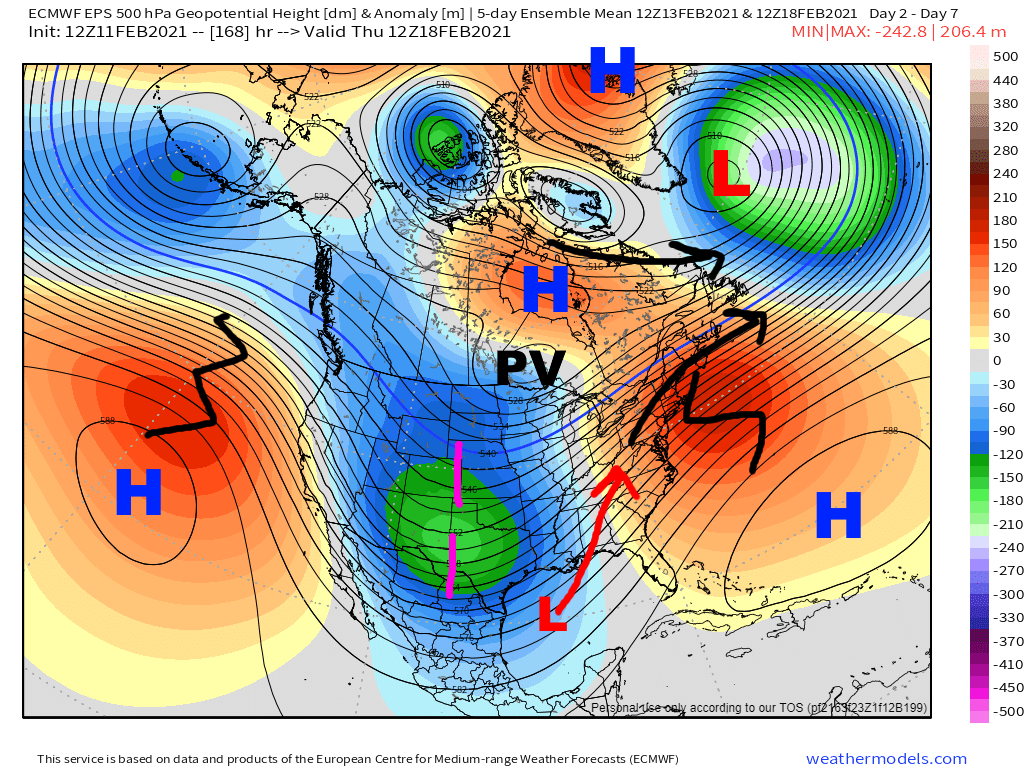
The pattern giving us this activity (representative EPS snapshot above) is not all that favorable for I-95 snowstorms. Before you throw beer bottles at me, I’m not saying it will rain on I-95, but except for maybe Boston don’t expect any of these storms to be predominantly snow along the I-95 corridor. However, it is still an impressive pattern and favors a lot of impactful wintry weather across the CONUS.

The trough over the western and central U.S. has a tap of truly Arctic air, with prolonged, strong high-latitude blocking and a cross-polar flow filling Canada with very cold air as a large piece of the tropospheric polar vortex gets displaced into North America. The lobe of the tropospheric polar vortex grazing the US / Canadian boarder is bringing this Arctic air with it into the CONUS.
However, the problem for I-95 getting all snow is the EPO is rising, the PNA is rather neutral, the NAO is somewhat negative but is east-based, and the coldest air dumped in over the western U.S. This all allows a Southeast Ridge to crop up. That’s good for the Ohio Valley and Great Lakes, but not so much the Mid-Atlantic. However, there is still strong confluence over southeastern Canada and New England in this pattern, favoring surface high pressure there and cold air damming east of the Appalachians. With the air over Canada Arctic in nature, it will be much colder at the surface on the East Coast than the 500mb maps suggest. The pattern strongly favors primary lows tracking into the Ohio Valley, with the confluence encouraging re-development off the East Coast. The primary lows will drive mid-level warmth north ahead of them, and any re-development may help keep places like Upstate NY and New England snowier, but farther south this is an icy look.

Note how there are multiple shots of Arctic air into southeastern Canada as pieces of the TPV move through next week. This will give us a quality airmass to tap. Also note the TPV generally consolidating and the jet becoming more zonal towards the end of next week as the AO briefly spikes, giving us at least a brief break in this very active wintry pattern after next week.
Now that the broad stage has been set, let’s look a little closer at the 3 systems on the radar from this weekend through next week…
This Weekend:

There are a few pieces here that will produce precip, some of it wintry. A vort max rounding the base of the polar vortex will produce a rather light swath of high-ratio snow from the central Plains into the Upper Midwest and Great Lakes Friday – Saturday. The shortwave over the western Gulf will move northeast and bring primarily warm air advection-driven precipitation to much of the southern and eastern U.S Friday night – Sunday. The next shortwave behind it over NM and northern Mexico will largely get sheared out as the next, more potent shortwave dives in from the northwest later this weekend (though if it survives, it is what is bringing the shot of lighter precip later Sunday into early Monday to the SE / Mid Atlantic that some models have). What really hurts over the eastern U.S. is the fact that the wave itself is rather weak, the wave spacing is poor, and there’s broad confluence over much of the eastern U.S. which will tend to shear this feature out as it lifts northeast.
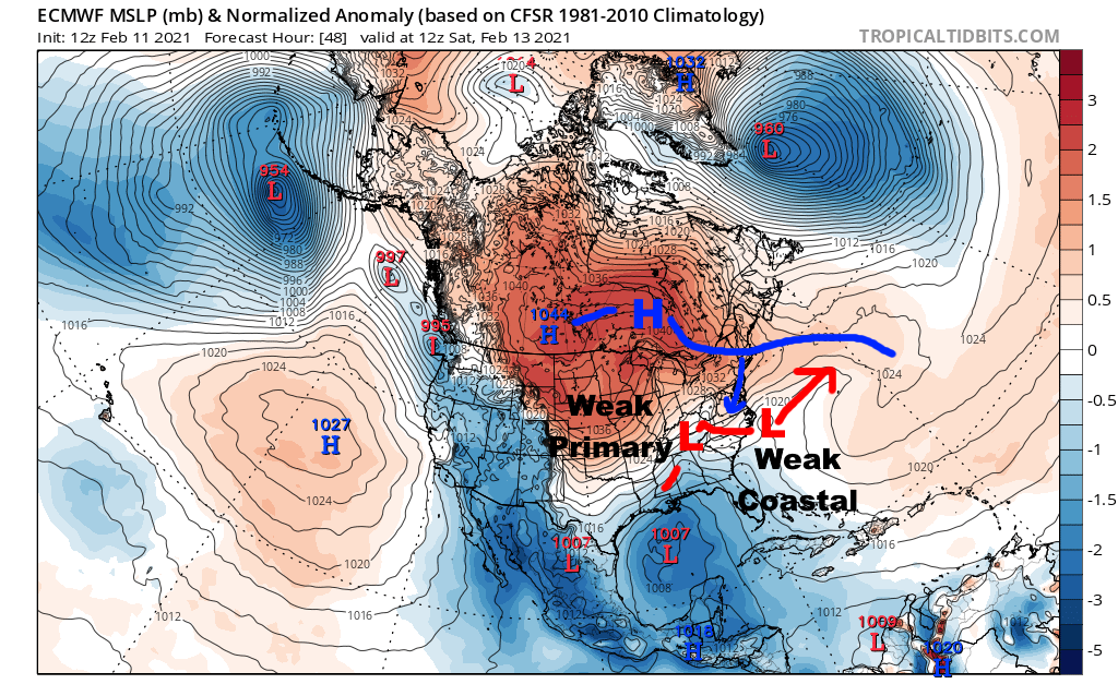
The result will be a weak attempt at a primary low into the Ohio Valley, and a weak attempt at a coastal. Neither will be strong and there won’t be a ton of QPF to play with, with the most QPF over the southeast and lower Mid Atlantic where the shortwave will still be stronger and where PWATs are higher. There may also be a relative uptick over PA, NY and southwestern New England as the vort max rounding the PV adds a bit of lift and improves jet support while the weak coastal makes its closest pass:

QPF will then begin diminishing again heading east across New England as this feature passes and we get into subsidence behind it.

This just isn’t a great set-up for snow due to a lack of robust coastal re-development and warm mid-levels. The bulk of the precip will be driven by low-mid level WAA. This lift briefly improves (with some suggestion of fgen ramping up too) Saturday evening / night as the best upper jet support glances the region, but the strongest fgen is located well below the DGZ across the board and is occurring near the retreating 850mb 0C line, just not a great set-up for a “thump” of snow before flipping to ice or rain. The relatively best shot of snow may be from northern PA and Upstate NY into interior New England where it will be colder and where all of the lift will briefly line up in an area cold enough for snow, but even here more than a localized few inches seems like a stretch.

The problematic aspect to this system is that there will be a tap of very cold and dry air to dam east of the terrain, with the weak coastal also giving a little isallobaric tug to the flow Saturday afternoon – night and re-enforcing this cold air damming. This will allow temperatures to hold below freezing west of the coastal front through much of VA and potentially into NC during this precip – note that cold air damming often trends colder as we get closer. Along much of the I-95 corridor temperatures will be well-below freezing during any wintry precip, so it may accrete or accumulate rather well and impact travel. There isn’t a ton of QPF to go around so in general I don’t expect enough freezing rain for significant power outage issues, though the one exception may be the lower Mid Atlantic (or interior NC if it’s cold enough). The low-levels are quite cold as you head northwest of the I-95 corridor which may favor sleet vs freezing rain for many areas for part of the storm, though a narrow corridor of predominantly freezing rain may play out somewhere near or just NW of I-95.
Monday – Tuesday:

Similar to the weekend wave, but also different. The lobe of the polar vortex is pulling east. While there is strong confluence / surface high pressure behind this feature (and a shot of cold air into the Northeast with it), it is moving to the east ahead of our ejecting shortwave. The shortwave ejecting is much larger as well. With a southeast ridge in place, this will send a robust primary low into the Ohio Valley early next week, followed by secondary development off of the Northeast coast.
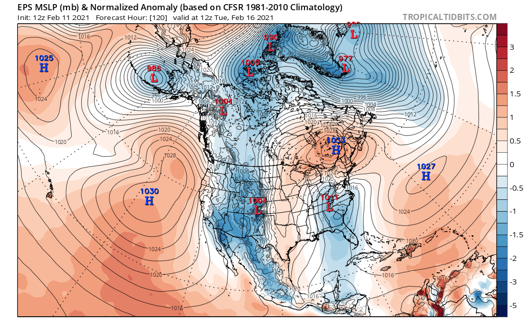
There is some uncertainty with regards to the exact details, as exactly how consolidated the wave is when it ejects out will influence the strength of the primary low into the Ohio Valley and can influence the coastal re-development. Some guidance ejects a little piece on Monday, resulting in a wave of overrunning precip well ahead of the main storm, and potentially resulting in a slightly weaker primary low. The next shortwave will also need to be monitored for wave spacing issues if it trends faster, which could also weaken the primary low. How quickly the PV moving across SE Canada ahead of the storm can also influence things; if it moves through slower it may favor a somewhat colder solution, but if it lifts out faster could favor a more amped primary low into the Ohio Valley and warmer solution for the East Coast.
The tl;dr here is to expect a primary low of sorts into the Ohio Valley, followed by eventual re-development off the Northeast coast…this isn’t going to go anywhere as it’s too obvious of a set-up that’s been shown strongly by most operational and ensemble guidance since it came into range, but it may trend more or less amped.

In terms of where this may produce wintry precip…given the record cold surging to the TX Gulf Coast this weekend and early next week, wintry precip is likely all the way to the coast in TX. As the primary lifts into the Ohio Valley a swath of moderate to locally heavy snow is likely across the Mississippi Valley into the Ohio Valley and southern / eastern Great Lakes, though note that there are ways this trends more or less amped. I generally feel these types of lows into the Ohio Valley trend more amped as we get closer, but the very cold air and dominant polar jet may limit that if the lobe of the TPV doesn’t lift out as quickly.
In the east, there will probably be some overrunning snow ahead of the primary low from the northern Mid Atlantic into New England, followed by some enhancement from the coastal from NY into New England. Much of the I-95 corridor (especially Philly and north) may see some snow from overrunning, but should flip to ice before getting a ton of snow.
It’s possible that Boston and Hartford are mainly snow if the primary low is on the weaker side and the coastal takes over quicker…NYC is close to the line but I don’t think they can avoid going over to ice or rain at some point. I think the farthest south this can be primarily snow, even with the colder solutions, is from central PA to maybe northern NJ (but outside of NYC itself) into southern New England (though as of now, I’d favor some ice even in this corridor unless we see the primary low trend weaker…that’s the farthest south I could see mainly snow if this trends less amped and colder).

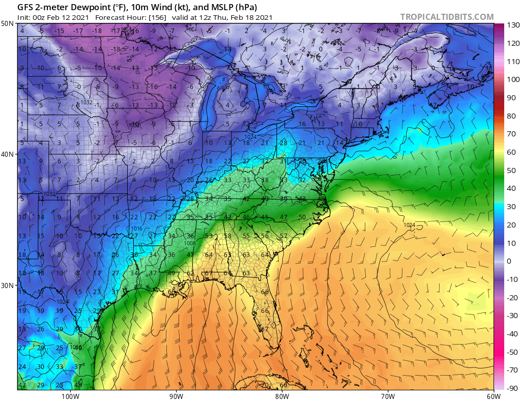
Despite the primary low likely flooding the mid-levels with warmth, the TPV will bring a shot of very cold and dry air to southeast Canada and New England that will funnel east of the Appalachians into the Mid Atlantic. West of the coastal front will be cold with this storm, certainly through DC and probably through most of VA (the GFS usually underdoes low-level cold in CAD). It is less clear-cut into the Carolinas, though I feel at least interior NC is in play for being cold enough for another round of freezing rain with this storm.
Basically, a lot of areas should get snow from this system, even if the exact placement can wobble. Even in the Northeast many should see snow before any ice, but the very cold / dry air funneling east of the Appalachians combined with a robust primary low into the Ohio Valley screams an icy set-up for a large chunk of the region, likely including NYC, Philly, Baltimore, DC, and possibly even Richmond again. Hartford and Boston are a little more on the fence for mainly snow vs a fair amount of ice, but very well could end up in the latter camp too. My gut here is that this is more likely to trend a little more amped vs flatter as we get closer.
Thursday – Friday:

So this is almost the same thing and I’m tired of labeling and typing out the same thing over and over again (since it’s like midnight). The key difference here for this storm is that there isn’t a lobe of the TPV sitting over SE Canada ahead of our storm, allowing for the SE ridge to extend all the way into eastern Canada. There is enough confluence for some surface high pressure and cold air damming ahead of the storm, but the quality of the air is not as good, the high pressure isn’t as strong, and the Miller B / coastal will be much more apt to track close to the coast given a weaker high pressure and less confluence north of the storm:
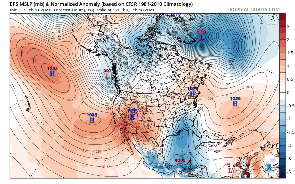
There is enough high pressure ahead of the storm for more cold air damming, and probably enough high pressure and confluence to coax a Miller B again, but overall it will be warmer than the Monday – Tuesday storm.
Using the GFS for demonstration purposes, note how along with weaker high pressure ahead of the storm overall (per the EPS images), the cold / dry air over New England and SE Canada is a couple of notches less impressive than what the Monday – Tuesday storm is working with. It’s still cold and dry enough that there may be overrunning snow ahead of the storm and again cold air damming, quite possibly into the Mid Atlantic, but it will be easier for the mid-levels to warm, and the cold air damming may eventually erode a bit more than it will with the early week system.
The result is still another potential swath of snow, both with the primary low from the southern Plains into the Ohio Valley and southeast / eastern Great Lakes and likely again over the interior Northeast, and still more ice, but overall it will probably be a notch or two warmer in the Northeast than the early-week storm.
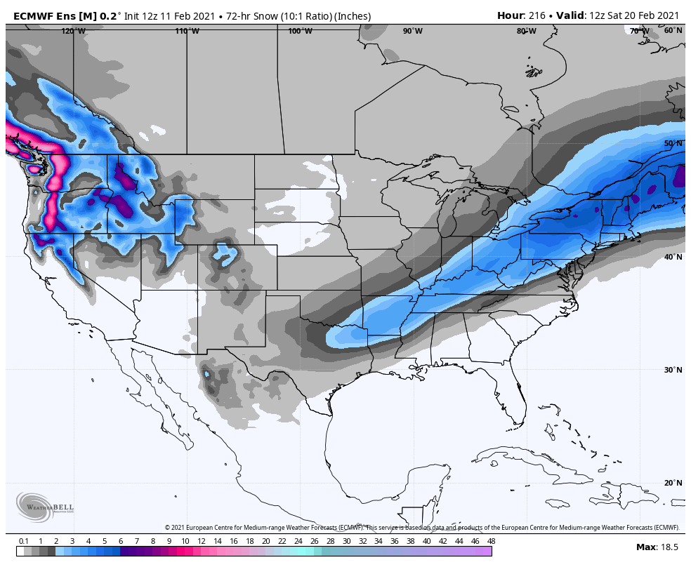
Note how the ensemble mean snow swath is actually fairly similar on the southern edge to Monday – Tuesday in the Northeast, but definitely has the heaviest swath located even farther inland.
Overall, 3 systems are coming up. In the interior Northeast they may be mainly snow, but closer to I-95 they all likely feature a fair amount of sleet and freezing rain (and maybe some plain rain farther south). Large swaths of impactful wintry weather can be expected with all 3, but especially the Monday – Tuesday and Thursday – Friday storms. Finer details are still a long way from being worked out, but there’s plenty to keep an eye on, including the risk for substantial icing through the week and power outage potential.
