
Forgive the crude map…gets the point across:
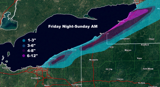
With the synoptic precip Friday morning temp profiles are close to supporting snow…there will be some dynamic cooling as lift is pretty good and the precip will be moderate, so the higher terrain in NE OH and NW PA will probably try to flip to snow for an hour or two…it may be enough to try to start lightly coating grassy surfaces and such…lakeshore probably just sees rain. NW OH a bit colder and better timing so will probably be some grassy accums there to start Friday.
For the lake effect over the weekend, it’s honestly more impressive than I initially thought parameter wise, but some questions about the duration and wind direction make it hard to be confident about a lot of snow falling in any given spot. My impression based on the parameters alone is that someone will hit the 6″/12 hour or 8″/24 hour warning criteria, but a band will need to lock in somewhere for that to happen.
The band will start taking shape late Friday evening as winds line up out of the WSW. With an approaching upper-low and extreme instability developing, it will likely be intense…it may graze the Lake, Ashtabula, and Erie lakeshore for a time, but at some point between 1 AM and 5 AM Saturday will lift out over the lake and come inland south of BUF as winds go more SW. The band will likely be mixed before midnight, but after midnight as 850mb temps crash to -10 to -12C by daybreak the band will be all snow/graupel down to the shoreline given its likely intensity. Winds lock in for a few hours Saturday morning, which could allow the band to slow enough to drop substantial amounts on parts of SW NY along the lakeshore and inland into the southern Buffalo suburbs. Instability will be extreme, with equilibrium heights of near 20k feet thanks to hilarious lake-to-500mb differentials of -45C (approaching -48C briefly). Wind speeds will be strong, but when the band is completely parallel to the long axis of the lake that should allow it to be organized enough. Given the instability, large-scale lift with the upper-low, full-lake fetch and strong convergence the band into SW NY will have a lot of lightning and likely contain very high rates…despite the wet snow, over 2″ per hour will be possible. Even though the duration is only a few hours, the possibility exists for up to a foot in SW NY if the band locks in Saturday morning. This could graze northeastern Erie County but I suspect if it locks in it does so just up the shore from Erie proper…though they could get grazed for a time late Friday night/early Saturday and see some snow.
The band will swing into most of the primary NW PA and NE OH Snowbelt Saturday afternoon as a surface trough pushes through and brings the winds around to the WNW over the lake. It probably won’t sit over the lakeshore for more than an hour or two as the wind shift is fairly sharp and abrupt, but given the likely instability and forcing it could drop a quick inch or two of snow/graupel near the shore. As for how far south the band can push and what kind of amounts it can drop inland, winds on land don’t really back from WSW as the surface high starts building in quickly Saturday evening. With WNW winds over the lake the band can probably get down to about Downtown and then push east across NE Cuyahoga and into northern Geauga, north of 322. It should get into central and southern Ashtabula as well as most of Erie County, but likely struggles to push into Crawford PA. It may maintain this southern extent for a few hours before drifting back north Saturday evening. The upper support quickly departs late Saturday afternoon and the inversion height lowers substantially, so the band intensity will likely be more moderate when it reaches its southernmost point…it could drop a light/slushy accum on the Cuyahoga lakeshore from Downtown points NE and perhaps a quick 1-3” inland in a few hours.
Overnight Saturday night instability does remain sufficient as the ridge builds in and slowly backs winds over land and pushes the lake effect back up the shoreline. With lightening wind speeds and lake to 850mb diffs remaining easily over 20C through the night, it wouldn’t surprise me if a moderate band or two does reorganize from parts of Lake County and perhaps the chimney of Geauga northeast across northern/central Ashtabula County and northern/central Erie County PA, perhaps into Chautauqua County NY as well later in the night. This band won’t be as intense, but will have light winds and good convergence so should be organized and likely won’t move quickly, so it could drop another 2-6” overnight Saturday night into early Sunday where it sets up.
Overall the potential for heaviest snow will be Saturday morning in SW NY and perhaps extreme NE Erie County, and I’m thinking a quick 6-12” with that where the band sets up…shouldn’t have issues accumulating along the lake given temps aloft and the expected intensity. Expecting a quick 1-4” across the primary Snowbelt as the band swings south Saturday afternoon/early evening before lifting back north…in Cuyahoga and Geauga Counties this is likely confined to along/north of 322 as it looks now. I expect another few inches in the northern Snowbelt overnight Saturday night into early Sunday as bands re-organize and slowly drift north as the surface ridge builds in and as enough instability hangs on.
