Disclaimer: The thoughts expressed in this post are mine alone, and in making any life or death decisions be sure to consult the National Hurricane Center, your local National Weather Service, and heed advice from your local authorities and emergency managers.
National Hurricane Center: www.nhc.noaa.gov
National Weather Service: www.weather.gov
General/non-scientific summary:
Tropical Storm Joaquin continues to intensify to the east of the Bahamas Tuesday evening, with maximum sustained winds as of 11:00PM of 70MPH. Any further increase in intensity would result in Joaquin becoming a hurricane, and this is expected to occur Wednesday morning. From there, rapid intensification is possible, and Joaquin could become a major hurricane by Thursday or Friday.
Joaquin is currently drifting west to southwest at about 5MPH. This generally heading is expected to continue through Thursday night, and would take Joaquin perilously close to the eastern Bahamas as a potentially strong hurricane Thursday and Friday. A hurricane watch has been issued for the central Bahamas.
After passing dangerously close to or over the Bahamas to end the work-week, Joaquin will turn north off the Southeast US Coast as a trough deepens over the Southeastern US. Whether the storm turns due north or northwest and heads towards the Mid-Atlantic or Southeast US coast, or turns more northeast and heads out to sea is uncertain, and will depend on the track and intensity of Joaquin through Friday.
Regardless of whether or not Joaquin directly impacts the East Coast as a hurricane or hybrid hurricane/Nor’Easter, a tremendous amount of rain is expected across the Mid-Atlantic and New England on top of already saturated soils as tropical moisture piles up along a frontal boundary in that area. Even if Joaquin misses the coast, a prolonged onshore flow Wednesday through Saturday would still cause at least minor to moderate coastal flooding. So, locations in the Southeast US, Mid-Atlantic and New England need to closely monitor Joaquin, as fairly significant flooding impacts are likely at minimum. If Joaquin does turn towards the coast, a very high impact and costly weather event would occur. Persons with interest form the Carolinas north all the way to New England need to closely monitor the progress of Joaquin.
Scientific Discussion:


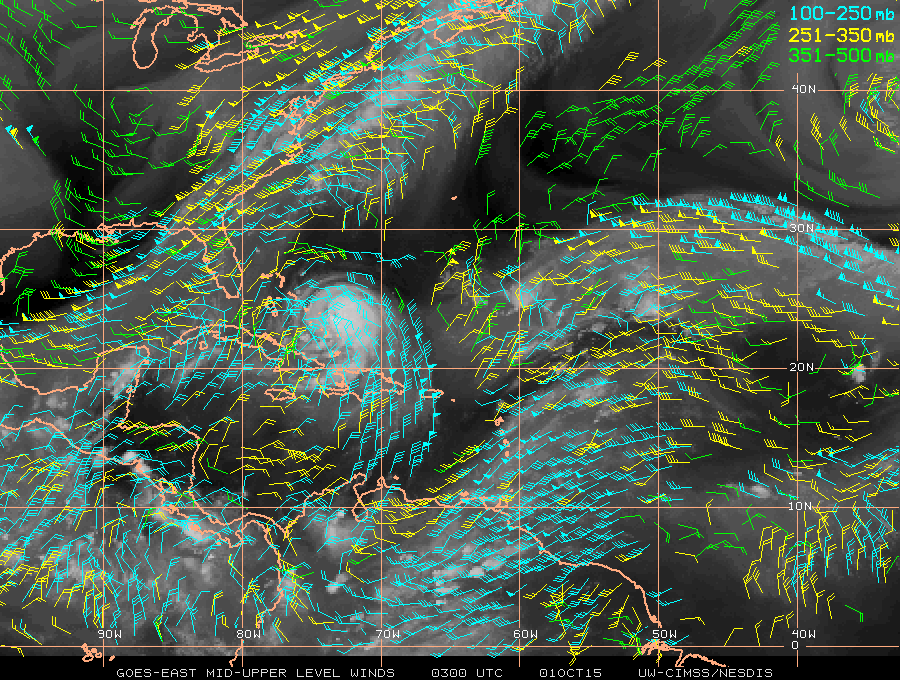
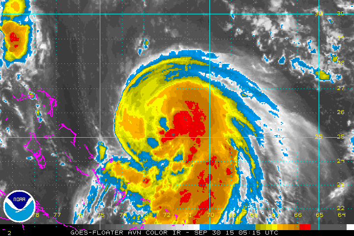
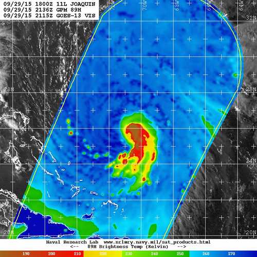
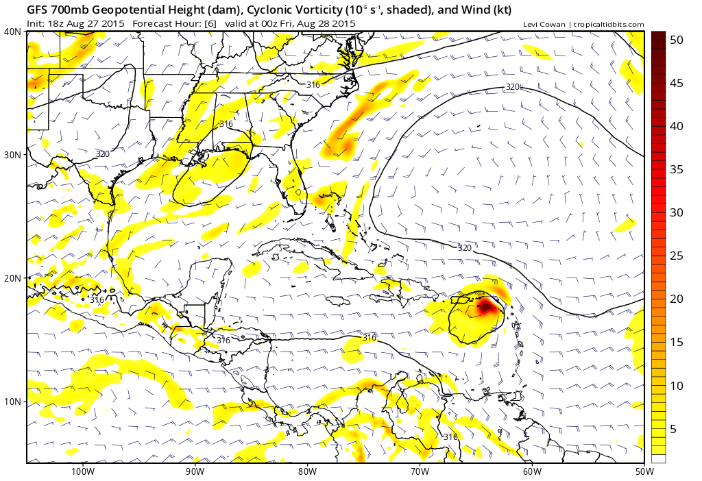
Recent convectional IR satellite imagery along with the most recent microwave pass that captured Joaquin (from around 5:00PM EDT Tuesday) show that Joaquin is still a sheared tropical cyclone, however very intense and persistent convection is occurring on the eastern side of the circulation, with evidence of curved banding and perhaps a formative mid-level eye on microwave data. Note how there’s a swirl of low level clouds on the microwave image near the northwestern edge of the convection, indicating the low and mid-level vortex of Joaquin weren’t quite well aligned at 5PM, as a result of moderate northwesterly shear on the cyclone. Although the structure wasn’t perfect this afternoon, as of 11:00PM Joaquin had maximum sustained winds of 70MPH and a minimum pressure of 988mb, which is a high end tropical storm.
Recent infrared loops seems to suggest that the centers may be slowly continuing to align as shear relaxes, as the swirl of low clouds associated with the low level center are becoming harder to distinguish, meaning the center may be slowly tucking farther under convection. Given the formation of an inner core starting to take place with the mid level vortex and very persistent, robust convection, once the vortex becomes more vertically aligned, rapid intensification is a reasonable possibility. This is supported by a strong equatorward outflow channel as seen on infrared imagery.

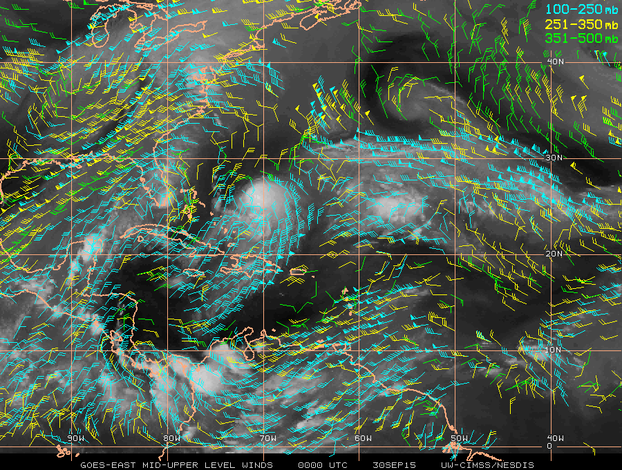
As discussed above, northwesterly shear has been affecting Joaquin thus far during its brief life as a tropical cyclone due to an upper level anti-cyclone to the west of the storm. As Joaquin continues to fire off intense thunderstorms and drift west, and as the anti-cyclone slides east a little bit, this shear will relax. There is already exceptional outflow to the south of the storm, and outflow would also occur to the north of the storm as the fringes of a jet streak over the southern and eastern US affect Joaquin over the next few days.

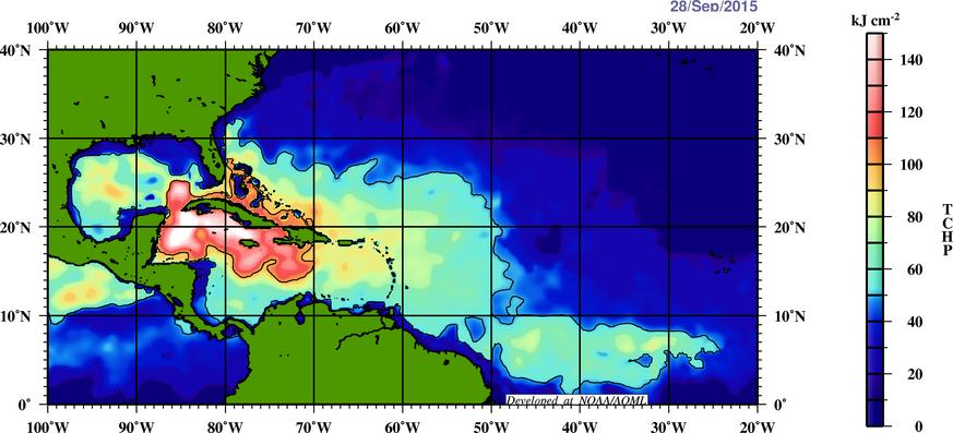
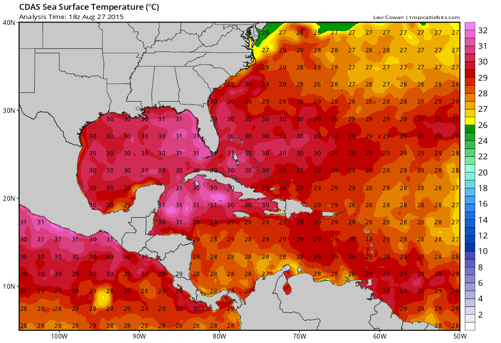
In addition to the low shear, strong outflow environment Joaquin appears to be moving into, water temperatures are very warm over and east of the Bahamas, with widespread 29-31C waters in this area. As per the image above, the warmth extends down to a reasonable depth until you get well north of the Bahamas, suggesting that even the Joaquin is slow moving, it shouldn’t upwell enough cold water to become detrimental over the next few days, assuming it keeps moving some.

There is some dry air north of Joaquin, however in general there is very moist and unstable air over the western Atlantic. Dry air usually doesn’t interrupt convection in stronger tropical cyclones if shear is low, which is expected to be the case soon, and otherwise the thermodynamic environment favors strengthening over the western Atlantic.
All told, signs point to rapid intensification of Joaquin being a distinct possibility over the next couple of days due to low wind shear, strong outflow, a favorable thermodynamic environment and warm to very warm water temperatures in the path of the storm. I expect Joaquin to become a hurricane on Wednesday and quite possibly a major hurricane by Thursday or Friday.

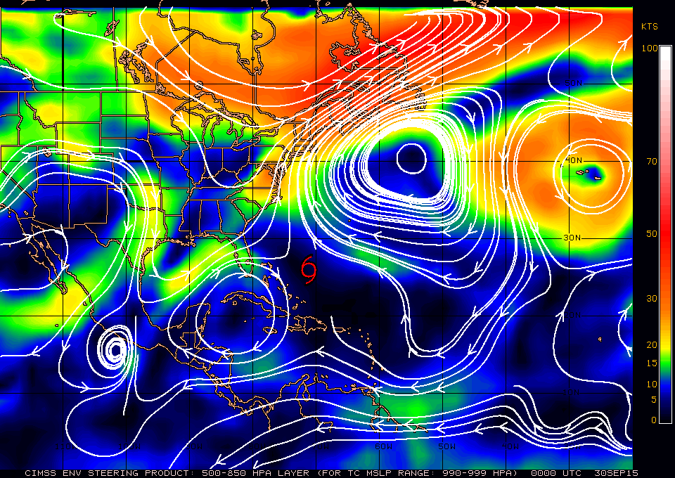
The track forecast of Joaquin in both the short and medium term is complicated, but of the utmost important due to potential impacts to the Bahamas and US East Coast. Joaquin is currently located within an area of weak steering currents; a large ridge is located over the NW Atlantic ocean, attempting to impact a west or northwest motion on the storm, while another, smaller ridge located over the northern Caribbean is attempting to impart a southeast motion on the storm, while at the same time a trough of low pressure is starting to dig across the eastern US, that may try imparting a northerly motion on the storm. Not to be forgotten, the remnants of Ida are located east of Joaquin, and while they’re too weak to have a steering impact now, if they reorganize then it’s quite possible they try to tug Joaquin more southeast as well.
Right now, the ridge over the Northwestern Atlantic appears to be “winning” for the most part with a general slow, westward drift. The question is, will that continue?
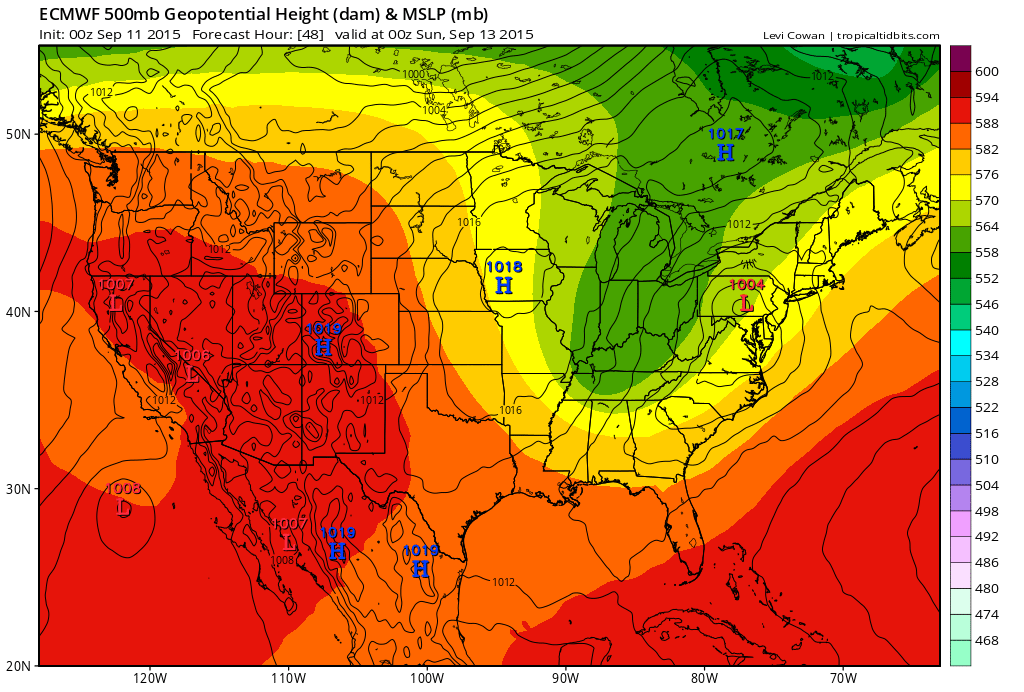
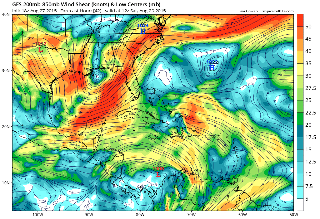
In the near term, as Joaquin continues to intensify, it appears that the ridge to its west may have increasing influence, as it appears to be stronger in the upper levels, per the layer of deeper steering currents shown in the above image. This could cause a west-southwest, but slow, motion to continue through the near term. However it’s important to note that if Joaquin does move farther north that it would feel increasing influence from the eastern US trough and ridge over the NW Atlantic. It’s also important to note that a stronger Joaquin would likely help pump up heights in the ridging over the NW Atlantic, which could ultimately try to push the storm farther west while also helping the trough over the eastern US amplify further.

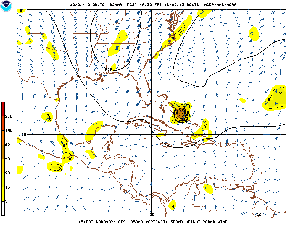
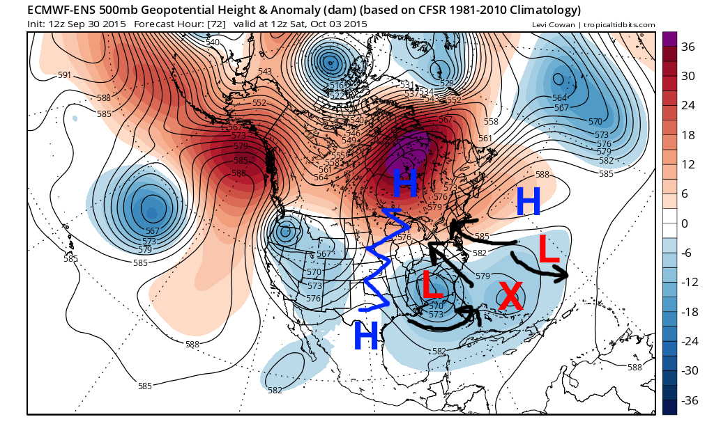
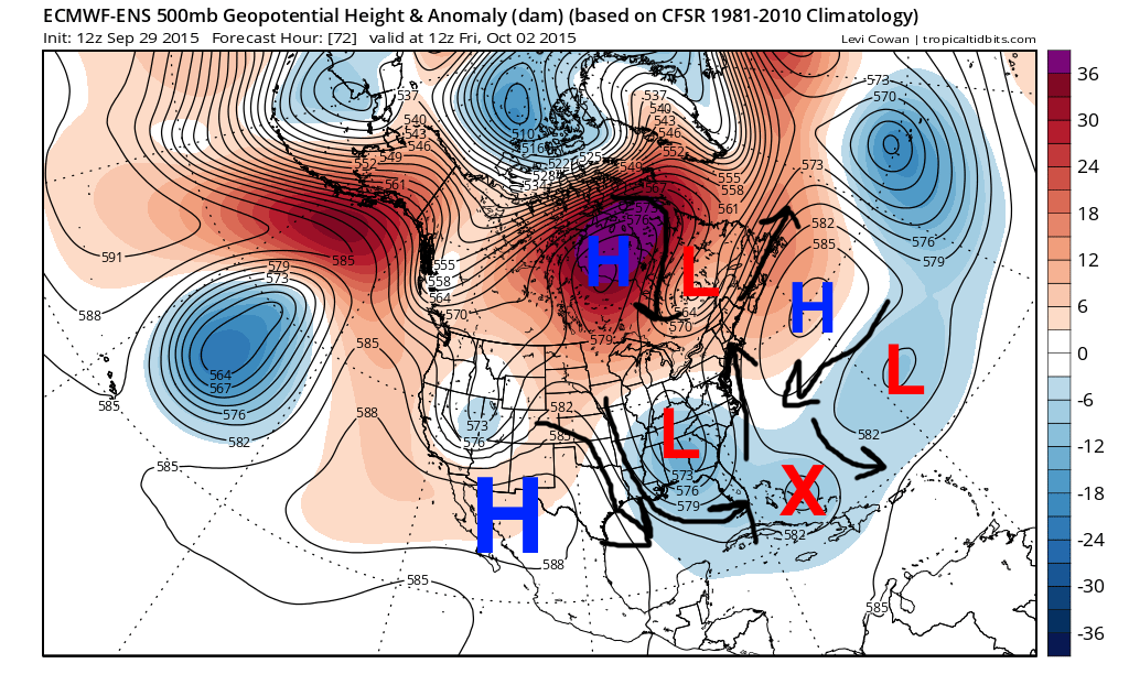
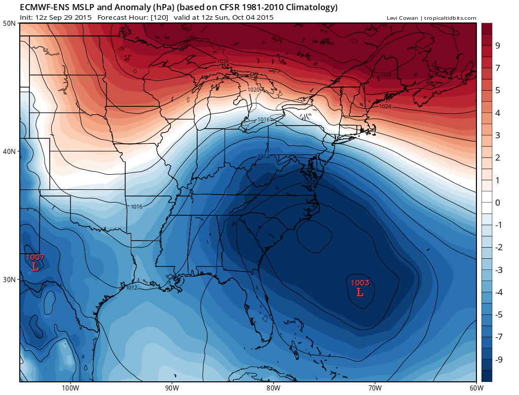
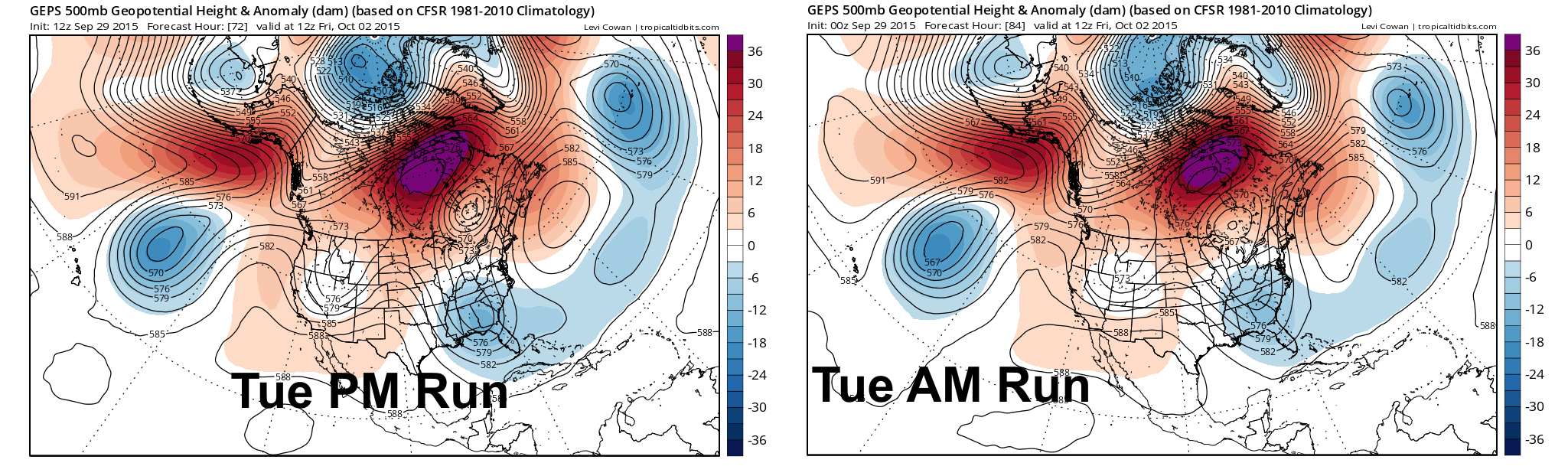
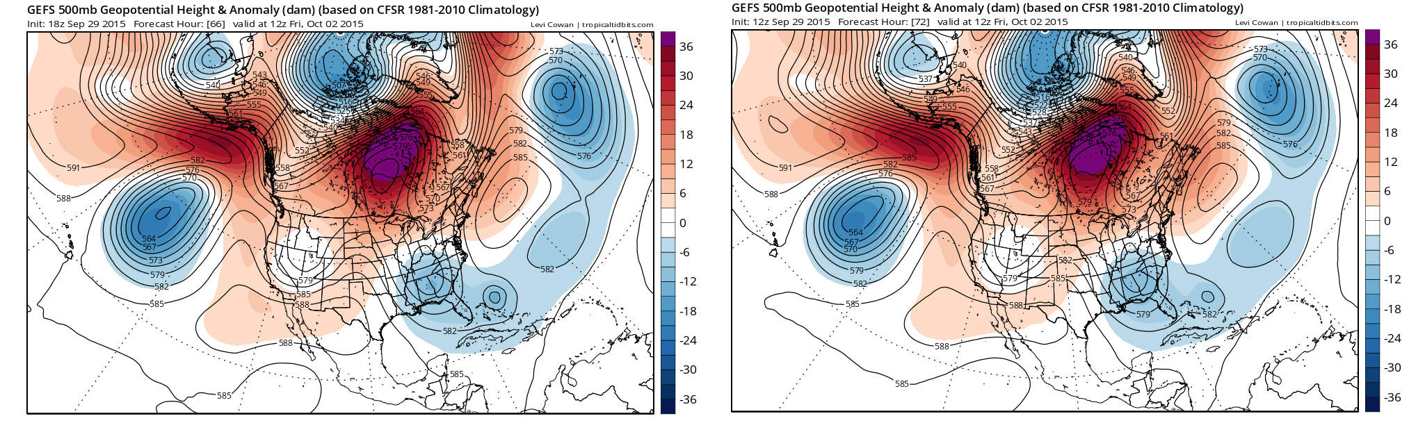
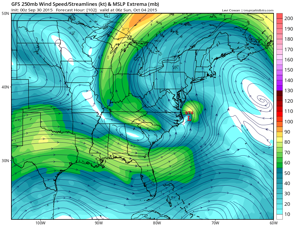
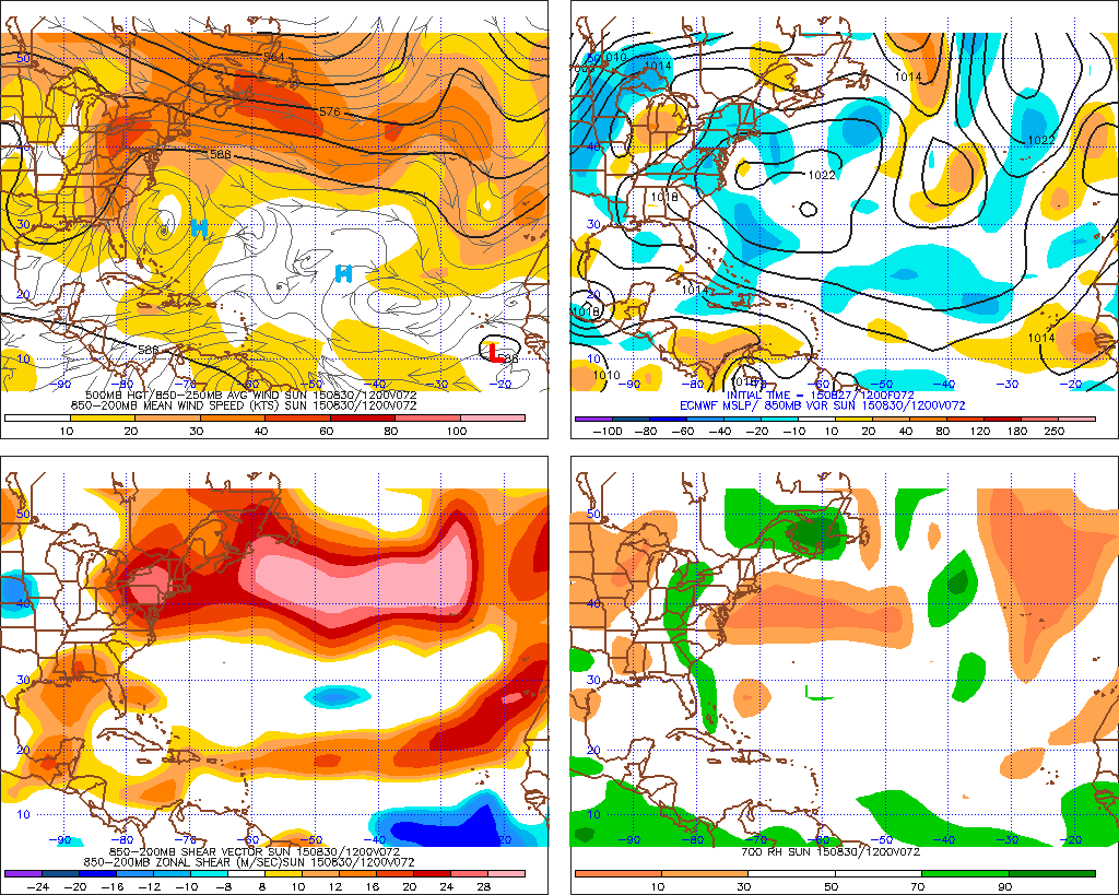
Several features are expected to be influencing the steering of Joaquin (X on the map) by Friday. The trough over the Ohio Valley/SE is expected to dig in response to ridging stretching from Mexico though the Midwest to near Hudson Bay. The NW Atlantic ridge is expected to prevent the trough from quickly sweeping off the East Coast. In addition, the ECM Ensembles (above) show a bit of a low south of the NW Atlantic ridge, possibly associated with the remnants of Ida. The low and high create a “rex block” which is hard to move, however, if the low becomes stronger east of Joaquin, it may have a larger impact on the steering of the system.
At this point in Joaquin’s life, there are three main options:
- The trough digs enough and/or Joaquin is far enough north that the flow around the SE US trough pulls the system north or northwest. The trough and Joaquin phase and the trough becomes strongly negatively tilted and cut off, allowing Joaquin to likely move into the Mid Atlantic coast.
- The trough doesn’t dig enough, or Joaquin is too far south, and the trough kicks Joaquin to the northeast. The NW Atlantic ridge is too weak and the low south of the ridge too strong to push Joaquin back towards the US Coast, the storm goes out to sea.
- The trough starts kicking Joaquin to the northeast, but the NW Atlantic ridge is strong enough to keep Joaquin in the fray, and the system eventually starts bending back to the north-northwest, potentially towards the northern Mid Atlantic or New England.
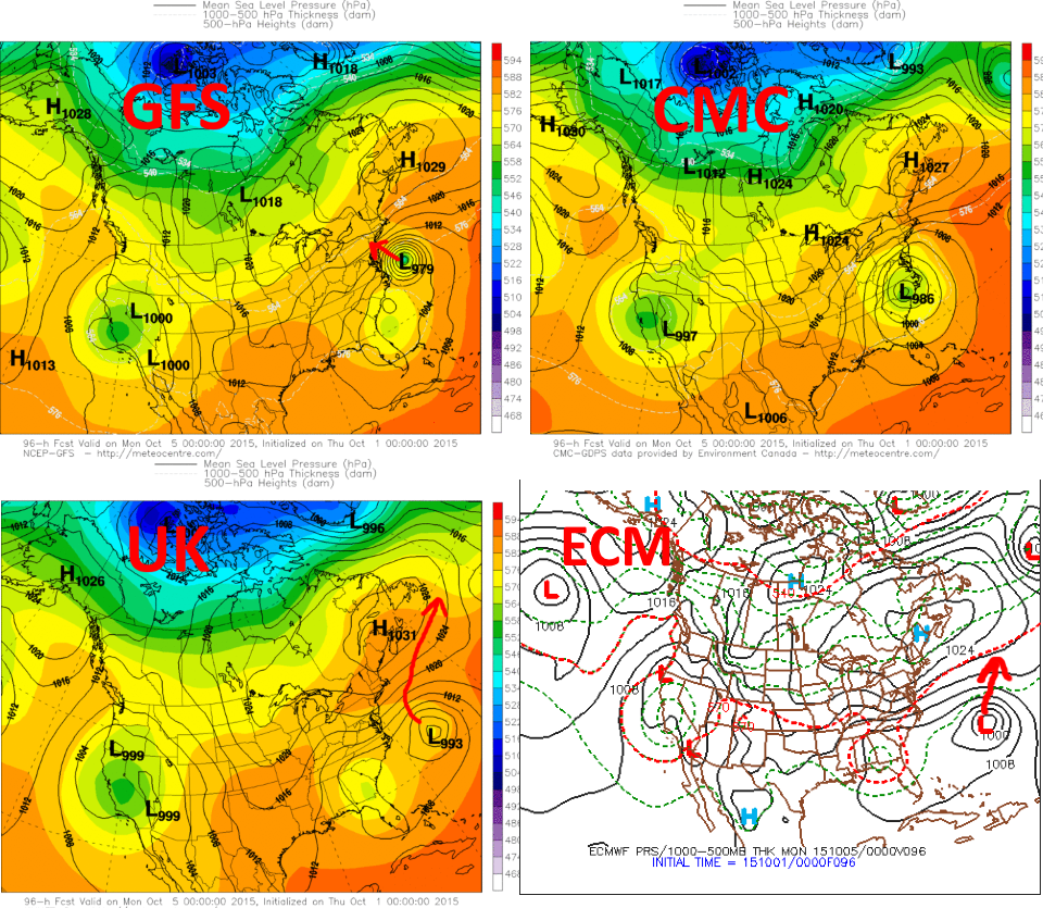
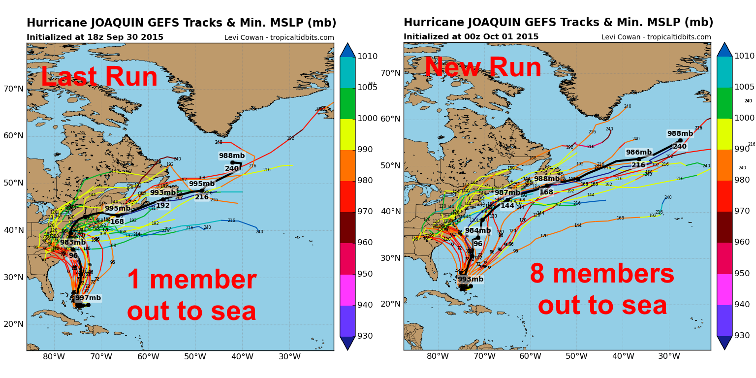
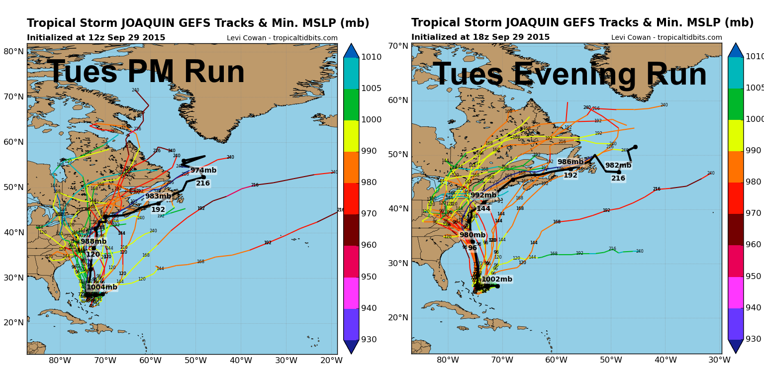
At this point, it’s hard to say which option is most likely. Wednesday afternoon’s CMC and UKMET models chose option 1 and showed Joaquin landfalling in the Mid-Atlantic this weekend. This afternoon’s GFS model and Euro both showed option 2 and took Joaquin out to sea, although significant rain associated with a predecessor rain event (PRE) still occur over parts of the Mid-Atlantic and New England. The 18z GFS trended significantly stronger with its representation of Joaquin and showed option 1 playing out, a significant run to run change in the model.
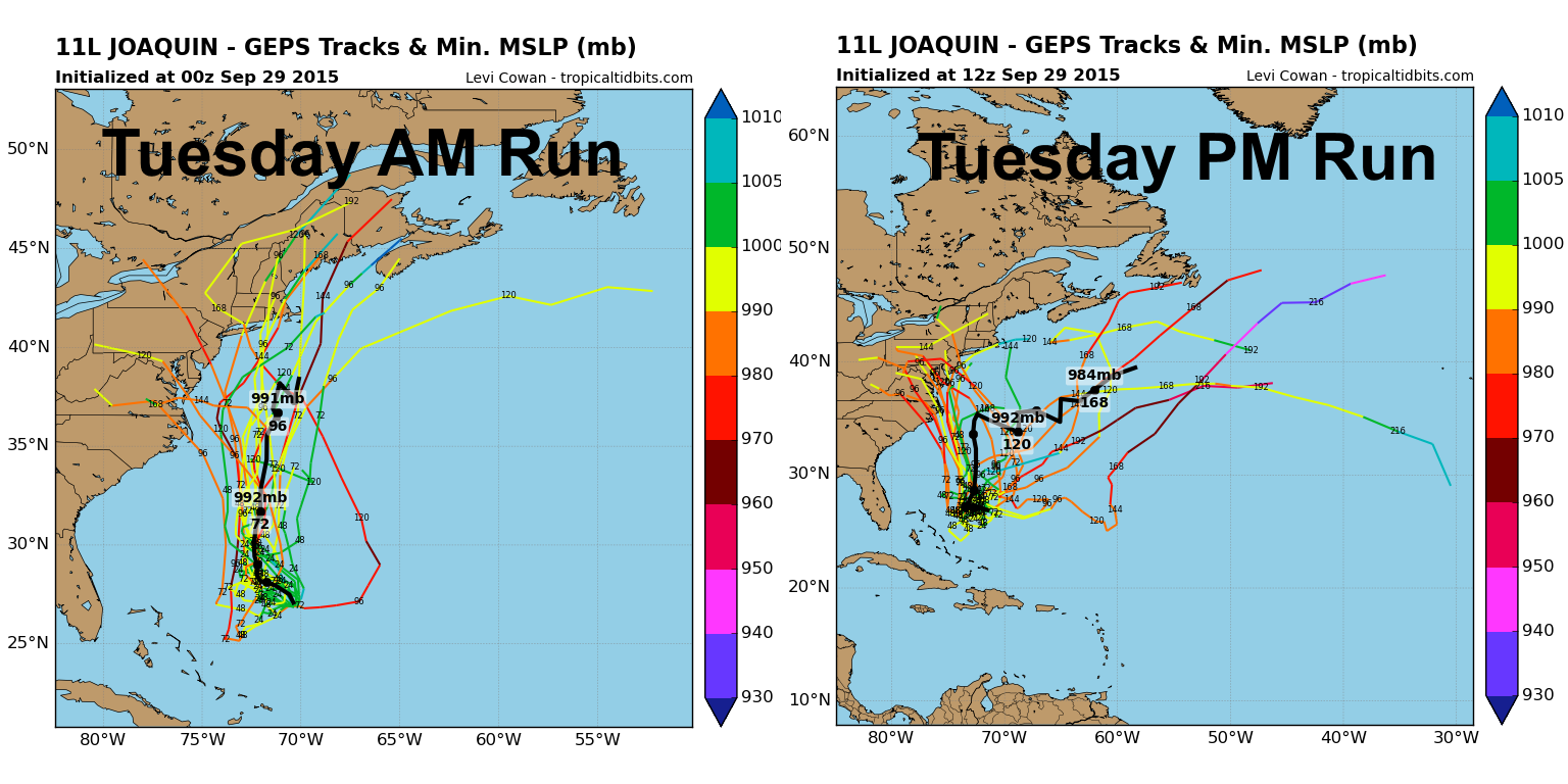
The 12z ensembles had some mixed signals, but were interesting nonetheless.
Canadian Ensembles:

The Canadian ensembles that were run late Monday night/early Tuesday mainly kept Joaquin on an option 2 or 3 track, with three members going into the Mid Atlantic, five going into New England and 5 staying completely out to sea. The Tuesday afternoon run showed more than half of the members taking Joaquin into the Mid Atlantic, with one brushing New England, and the rest (five) staying out to sea completely. A definite trend to the “left”. It’s also worth noting that more 12z members took Joaquin very close to the Bahamas.
GFS Ensembles:

Much like the Canadian ensembles, the GFS ensembles have trended significantly LEFT today, with the emphasis shifting from about even across the Mid Atlantic and New England to more Mid Atlantic hits.
ECM ENS:

The European ensembles in general, on the mean, appear to keep Joaquin off the coast, however it appears that a sizeable camp take Joaquin into the Carolinas or extremely close to them.
In general, there is ensemble support for all three possible solutions above, although in general the trend today from every model except for the operational Euro has been to the west or left, towards the East Coast or farther south on the coast. You can see why when looking at the changes in the patterns on the ensembles for the Friday-Saturday timeframe:

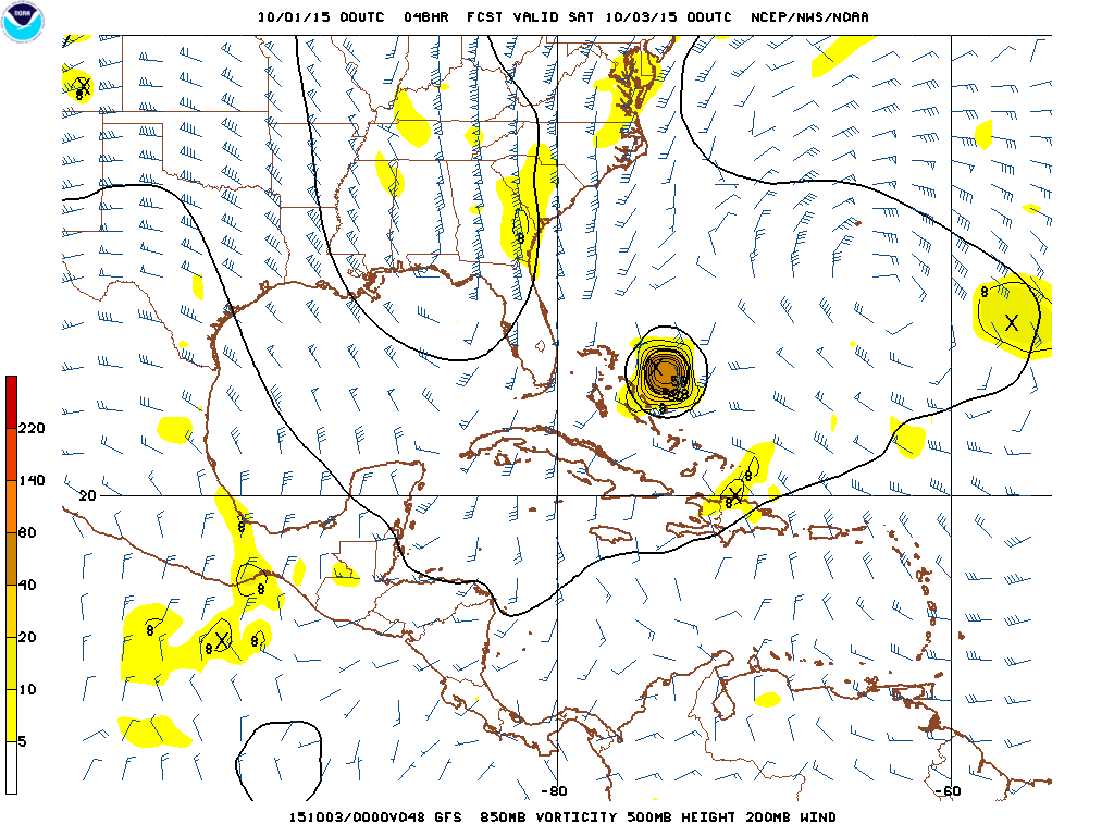
The GGEM ensembles show a much more robust trough over the SE US that digs farther and cuts off sooner. If Joaquin is too far south of the base of the trough, it would get kicked east by it. If it is along or north of the latitude of the base of the trough, and the trough cuts off sooner, it’s more likely to get pulled back west by it.
A similar trend is noticeable on the GFS ensembles:

Also of note, the later runs of the ensembles also appear to be slightly stronger with the NW Atlantic ridging, which may be key in helping the trough stall/dig while making it harder of Joaquin to slip east.
The Euro ensemble images are only freely available on 24 hour intervals and I don’t want to post off of a pay site right now, but the trend is noticeable in both NW Atlantic ridge strength and SE US trough strength/location.
The TREND has been for a pattern more conducive for Joaquin tracking towards the eastern US.
It should ALSO be noted that the trend on the GFS runs (0z Wednesday run continues the farther west trend) occurred when the model finally started properly depicting Joaquin’s expected near term strengthening. This makes sense, as a stronger hurricane would help amplify the ridging over the NW Atlantic, which at the end of the day makes a Joaquin eastern US landfall more likely.

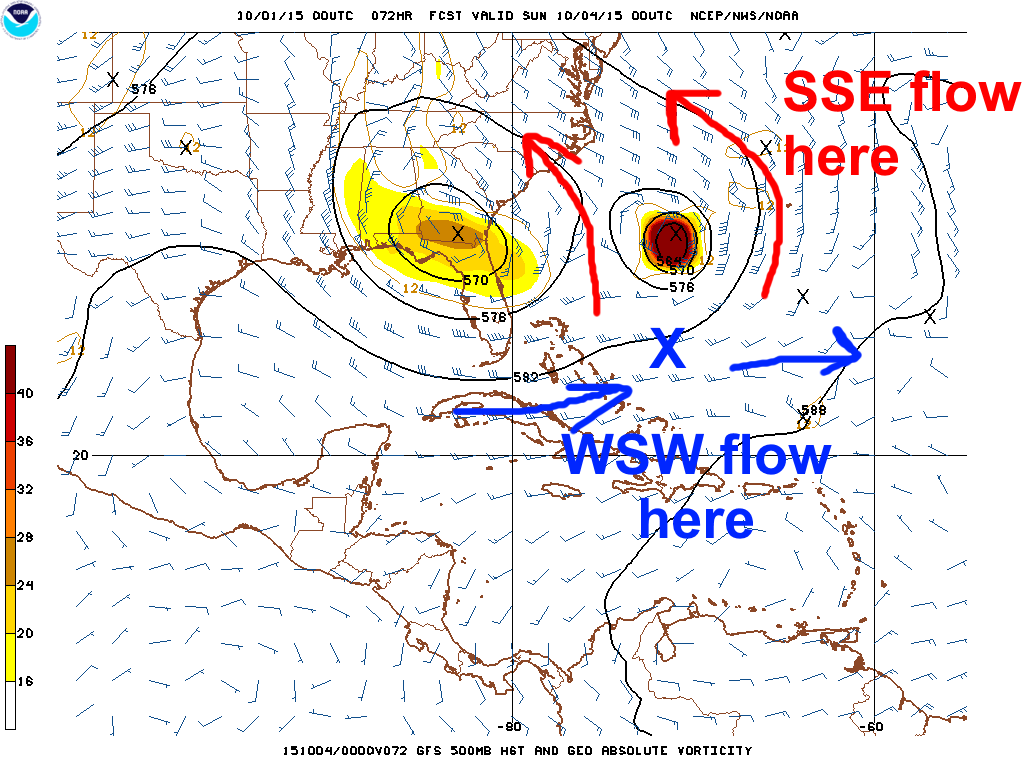
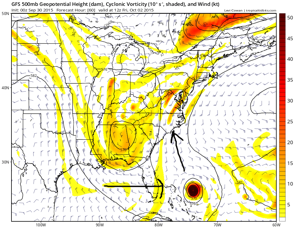
Where Joaquin goes over the next 2-3 days is also important. The farther SOUTH Joaquin is, the more likely it is to be “punted” east by the base of the trough. Note how near Joaquin’s latitude on the GFS there are westerly winds south of the trough, but just north the winds turn northerly. The farther north Joaquin is, the better the odds it doesn’t curve out to sea.
It’s somewhat counterintuitive, because a stronger Joaquin may track slightly more south in the near term, but could also help beef up the ridging which in turn may cause the trough to dig farther south anyways. The recent west trend in the models is generally associated with the global models showing a stronger Joaquin, so I believe a stronger system is more prone to hooking back towards the east coast.
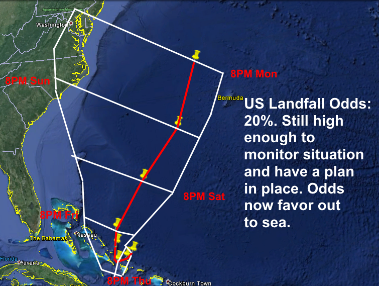
As of right now, I believe the left trend in today’s models made sense. My forecast track will follow the model consensus to very close to the central Bahamas, and then follow a 0z GFS/Canadian/UKMET/GFS ensemble blend. Further adjustments left could be needed if the trend for a pattern more conducive for a hard left turn towards the coast continue. The track forecast is delicate, so a miss out to sea is still possible. Continue to monitor this over the next few days!

Should Joaquin hook back towards the coast, strong upper level divergence near the right-entrance quad of a jet streak downstream of the SE US upper level trough could provide a baroclinic assist as Joaquin approaches land and moves inland. Water temperatures drop off quickly north of the VA/NC boarder, however this large scale ascent may help Joaquin grow larger and slow how quickly the pressure rises once it starts weakening near and upon landfall.
This jet streak could also start shearing Joaquin just prior to landfall. Unless Joaquin goes well north towards New England, I believe it would be mostly tropical at landfall due to warm SSTs up to near the landfall point and shear not increasing until just prior to landfall, although some degradation to the storm’s structure as it nears the coast and some weakening would still likely occur.

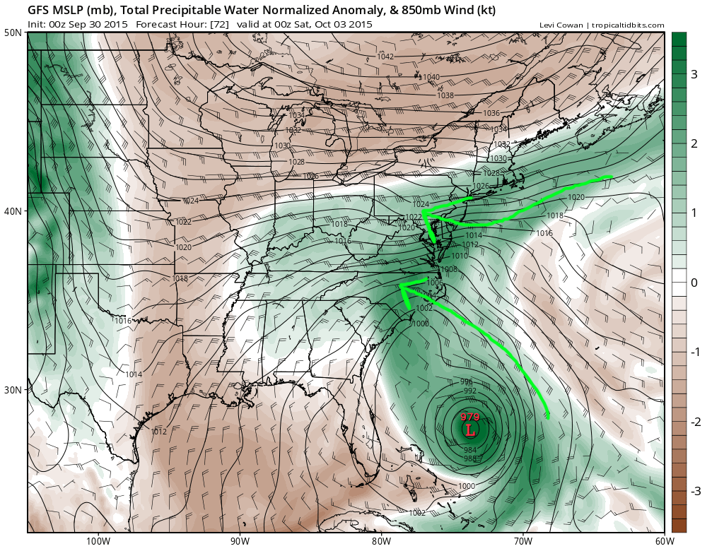
Whether or not Joaquin makes a direct landfall on the east coast, a prolonged period of easterly winds will bring abnormally high moisture into New England and the Mid Atlantic. This moisture will run into a frontal boundary stalled near the coast and produce days of heavy rainfall for these areas on top of already saturated grounds. If Joaquin’s center actually crossed the coast, some areas would see even more excessive rainfall.

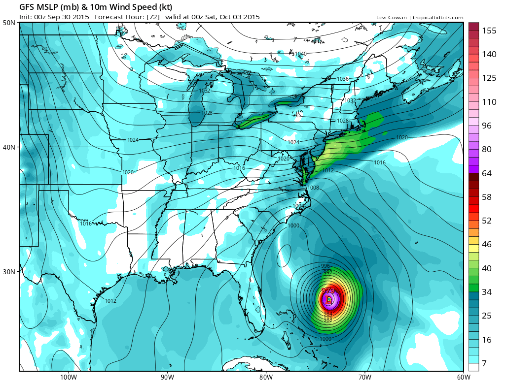
In addition, a strong pressure gradient between Joaquin and a high pressure over Canada will cause a prolonged, strong onshore flow into the Mid Atlantic well ahead of the storm. Regardless of if Joaquin hits the coast, moderate coastal flooding seems quite possible. Severe storm surge could occur if Joaquin hits the coast directly, especially since water will be piling up WELL before the storm.
Significant flooding and downed trees could occur well inland into Appalachia should Joaquin make a direct landfall and sling shot more west like some models like the HWRF, 0z GFS and 12z UKMET show.
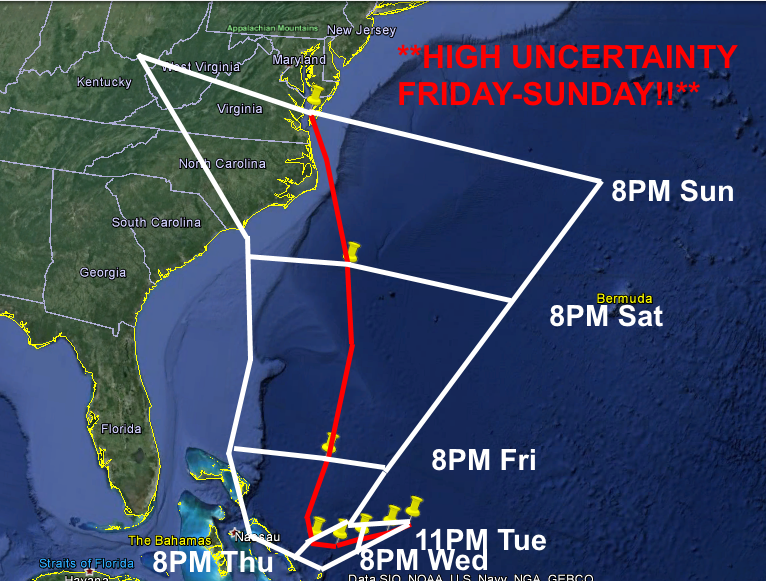
Forecast Map:

Coordinates/Intensity:
11PM Tue…Initial…25.8N, 71.7W…60 kt TS
8AM Wed…25.5N, 72.4W…65 kt Cat 1
8PM Wed…25.2N, 73.3W…85 kt Cat 2
8AM Thu…25.0N, 74.0W…95 kt Cat 2
8PM Thu…25.0N, 74.8W…105 kt Cat 3
8PM Fri…27.5N, 74.5W…110 kt Cat 3
8PM Sat…33.0N, 74.2W…100 kt Cat 3
8PM Sun…37.5N, 76.0W…80 kt Cat 1
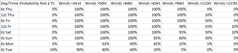
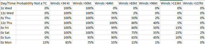
Intensity probability table: