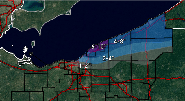
Seasonal forecasts are difficult, as you are predicting the average weather pattern months in advance, as opposed to the normal hours or days. Many factors go into making a seasonal forecast, such as water temperatures around the world, snow cover, and the stratosphere, to name a few of the bigger ones. Often times some factors dominate over others, or not one thing dominates, making for a harder forecast. Last winter was a very strong “El Nino,” which favored warmer conditions across much of the United States. This winter will be a weak La Nina, which does favor colder conditions, particularly across the Northern US, however the weak nature of the La Nina makes the confidence in this forecast lower. Here are the forecast maps:
December (temperature and precipitation compared to normal):

January:
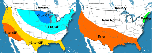
February:

It is important to note that these are AVERAGES for the months; it can rain or snow on one day but still be drier than normal; conversely, it can be warm one day but still be colder than normal for the month. These are the predominant conditions that I expect each month to average out to.
I expect this winter to be much colder than last winter across much of the country, especially the north, with January being the coldest month. An active storm track from parts of the Ohio and Tennessee Valleys east towards the northern Mid Atlantic and New England could mean normal to above normal snowfall in this corridor, especially if the temperatures behave as I expect them to. The Great Lakes may also see more snow than normal, with an active lake effect snow season. The northern Rockies may also see more snow than normal. Conversely, the Southwest and Deep South are expected to be predominantly warm and dry this winter. Can it snow in these areas; sure…but in general these areas will see a dearth of snow and cold chances.
Seasonal forecasts can go wrong, but this is my best guess.
Here is the meteorological reasoning and research behind those maps:
First, a link to last year’s forecast. An extremely strong stratospheric polar vortex caused my February forecast to bust hard.
Jim Sullivan’s 2015-2016 Winter Outlook for the United States
This year’s forecast is a little less clear-cut than last year’s, and considering I had so much trouble with February last winter perhaps that’s a bad thing. Last winter featured a near record-breaking El Nino driving the weather pattern, this winter does not look to have such an obvious forecast signal.
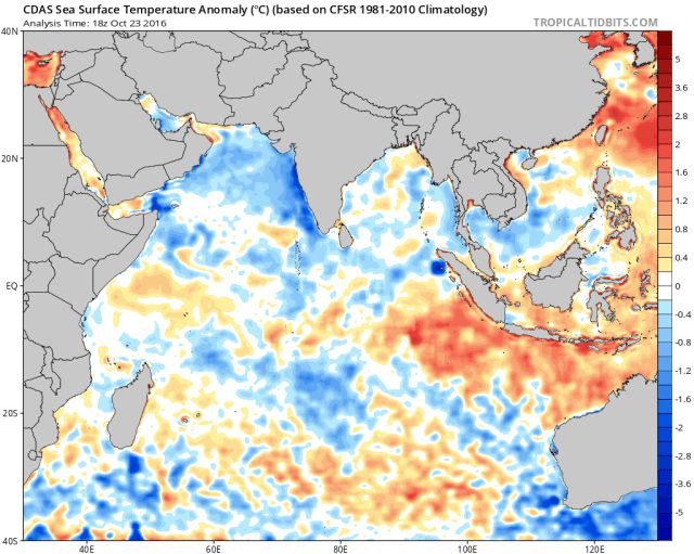
Global Sea Surface Temperatures:

A weak La Nina has been attempting to develop in the Pacific all summer with limited success. With that said, the warm pool has shifted west to near Australia and Indonesia, with cooler waters in the Indian Ocean. This suggests early on that tropical forcing may be focused west of the Dateline, which is considerably farther west than last winter and is more typical of a La Nina. The north Pacific as a whole is very warm, however the northwest Pacific has warmed to similar levels as the northeast Pacific, suggesting that the recent positive PDO from the last few winters may be weakening/trying to flip back to negative. The Atlantic as a whole is very warm, with a notable cold pool south of Greenland and Iceland.
I will look deeper into the pattern in the sea surface temperature anomalies, especially in the tropics, and developments in the stratosphere and troposphere, and how these developments may impact where/if high latitude blocking occurs through the winter.
El Nino Southern Oscillation (ENSO):
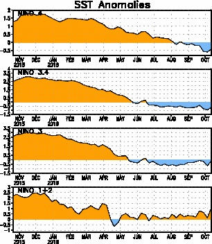
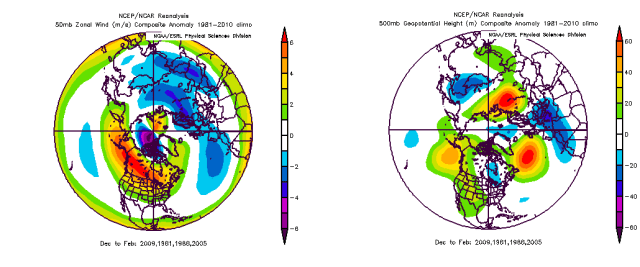
After a record or near record basin-wide El Nino dominated the winter of 2015-16, the waters in all of the Nino regions have cooled substantially through the Spring and Summer. The decline has been somewhat slower than after past strong El Nino events, however a recent surge of cooling in Nino region 3.4 has increased confidence in a weak La Nina for the upcoming winter (sea surface temperature anomalies in 3.4 of -0.5C to -0.9C for 5 consecutive 3 month periods).
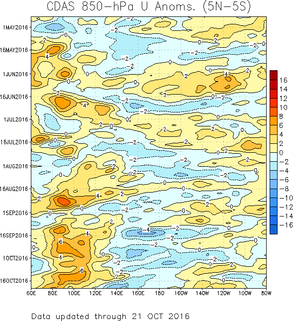
One reason for why this La Nina has been slow-developing may be due to a lack of persistently stronger than normal trade winds in the equatorial Pacific through the Spring and Summer (denoted by cool colors). There has been a somewhat stronger burst of trade winds since early September, but still nothing very strong, with normal or slightly weaker than normal trades at the same time east of 160W. The sub-surface cold pool, due to a lack of stronger trade-winds to upwell colder waters, is not extremely impressive and doesn’t appear to be getting more impressive at this time:

The Southern Oscillation Index, which measures the sea level pressure difference between Tahiti and Darwin, and is a good indicator of how strong the trade winds may be across the Pacific, has been running weakly positive all summer. This indicates somewhat stronger trades than normal. September saw a stronger positive number, coincident with stronger negative zonal wind anomalies on the 850mb time-longitude plot above, and also a bit of a dip in sea surface temperature across the central and western ENSO regions on the graphs above. The 30-day mean as of October 23rd is however not as strongly positive, with the most recent daily index being negative, which suggests the sea surface temperature anomalies probably won’t cool a ton more as we head into the winter:

Given the combination of trade winds struggling to stay strong, the only gradual cooling of waters in the ENSO regions, and the sub-surface cold pool being rather run of the mill and not getting larger/stronger, I think the La Nina will remain weak this winter. It’s still not impossible that the waters warm later in winter and make it difficult to maintain an anomaly of colder than -0.5C in ENSO region 3.4 for 5 consecutive 3 month periods, which would make the winter a “cool but neutral” ENSO if that occurred, officially. Regardless, the warm waters near Indonesia suggest tropical convection and hence forcing will probably be focused west of the Dateline this winter, which is a key feature in La Ninas. Given this, we’ll probably see the weather pattern across North America resemble one more common with La Nina events this winter. La Nina events often feature a weaker than normal sub-tropical jet stream, meaning warmer and drier conditions compared to normal across the southern tier, and ridging over the northern Pacific, which often provides cooler conditions to the northern tier, particularly in the west. There are often variations to these patterns, but per the CPC, here is what the “typical” La Nina weather pattern looks like:

My forecast won’t necessarily match that, due to the weak nature of this La Nina and other factors that may contribute to the weather pattern…however, ENSO is still the best predictor of the upcoming winter’s weather pattern (as last winter illustrated), and it is important to understand what La Nina events and El Nino events typically entail…and go from there.
The Indian Ocean:
The ENSO alone does not determine where tropical convection, which is a key driver of the global weather pattern, occurs. Convection occurs in the Indian Ocean, and if the Indian Ocean water temperatures aren’t “in sync” with ENSO then the ENSO correlation with the weather pattern may weaken some.
Currently, water temperatures are warmer than normal from Indonesia east towards Australia and Malaysia, and are near or cooler than normal in the bulk of the Indian Ocean, with the most substantial cool anomalies west of Indian. This is a classic “negative” Indian Ocean dipole, per this graphic courtesy of the Australian Bureau of Meteorology:

A negative IOD is typically associated with La Nina conditions. With this said, sometimes a cool neutral or weak to moderate La Nina winter don’t occur in a negative IOD. Although there’s a small subset of cool neutral ENSO or La Nina winters that occurred with a +IOD since 1960, the difference between those winters and cool neutral winters with a –IOD shows more precipitation near Indonesia, Malaysia, and northern Australia, and less precipitation over the Indian Ocean and east of the Dateline over the Pacific:

This suggests that La Nina winters that occur with a –IOD are more “typical” La Nina winters, with tropical convection focused west of the Dateline BUT ALSO east of the Indian Ocean. Due to the small sample side of +IOD/cool ENSO years, I’m not going to post a bunch of these comparison maps here. The gist here is that La Nina “stuff” should work well this year with a –IOD, suggesting subsidence and a weaker Indian Ocean Hadley Cell, common with La Nina conditions in the Pacific.
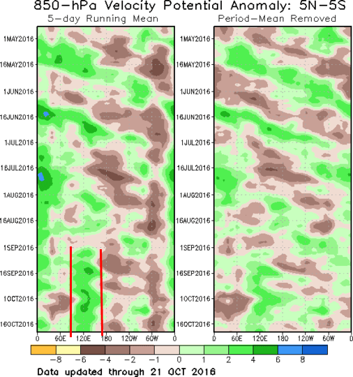
Although the signal wasn’t strong over the summer, vertical velocity potential (where lift and subsidence are occurring) shows a more coherent La Nina signal since early September…with uplift west of the Dateline but east of the Indian Ocean, and subsidence over the Indian Ocean and east of the Dateline. Not an extremely strong signal, but definitely coherent.

This is having an effect on the pattern over the last 30 days; the uplift is resulting in a stronger Hadley Cell between 100E and 160E, causing a stronger jet stream north of this Hadley Cell due to a stronger temperature gradient, with a weaker jet stream north of the subsidence and weaker Hadley Cells. Note the signs of a north Pacific anti-cyclone over Alaska, caused by the exit quadrant of the jet streak supporting storminess over the Bearing Sea, promoting higher heights to the east. This general pattern continuing into winter would support north Pacific ridging and some form of troughing over North America as wavelengths get longer.
The Atlantic Ocean:

As mentioned earlier, waters in the Tropical Atlantic are warmer than normal. This represents a positive/warm Atlantic Multidecadal Oscillation, which we’ve generally been in since the late 1990s. The Atlantic is smaller than the Pacific/Indian Ocean by a fair margin, however tropical convection does still occur over the Atlantic, and warmer or cooler waters compared to normal here can have some influence on the large scale weather pattern.
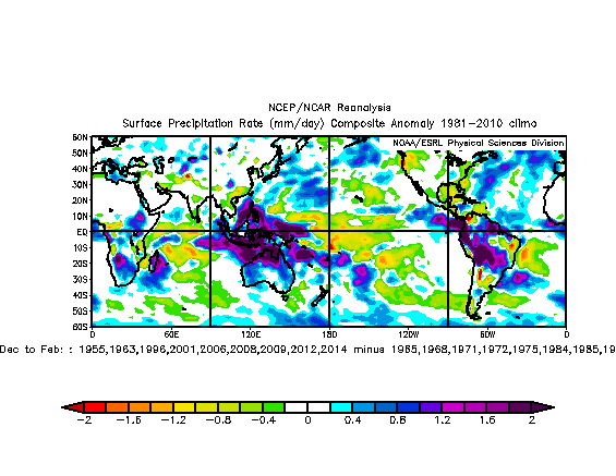
To determine how the AMO may affect tropical forcing, I took all weak to moderate La Nina winters (along with a few cool neutrals that were close) since 1950 and sorted them by AMO phase. Subtracting the –AMO years from the +AMO years shows that tropical forcing appears to be more “typical” of a La Nina in the Pacific in +AMO years, with stronger subsidence/denoted by less precip over the tropical Pacific east of the Dateline and stronger uplift/denoted by more precip farther west:
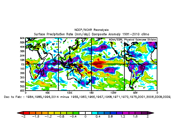
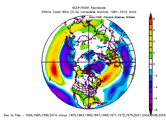
There also appears to be stronger uplift over South America and stronger subsidence over the Indian Ocean in +AMO years. This alters the strength of the Hadley Cells and hence the jet stream to the north of the tropical convection, and this can be seen when running the same comparison, this time looking at the 250mb zonal (west to east) winds:

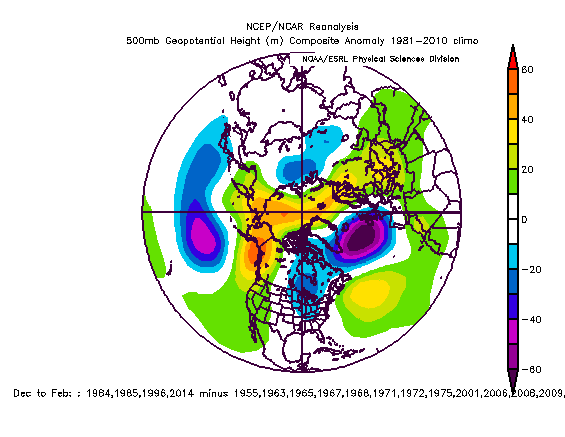
Note how +AMO La Nina years tend to have a stronger sub-tropical jet across southern North America, a stronger polar jet over the North Pacific south of the Aleutian Islands, and a somewhat stronger polar jet over the North Atlantic. This look on its own suggests increased storminess off the Northeast and Mid Atlantic coasts in +AMO La Nina years compared to in –AMO La Nina years. There is one notable difference in 500mb heights between +AMO La Nina winters compared to –AMO La Nina winters:

Heights are on the mean higher in +AMO La Nina years over western Canada than in –AMO La Nina years. This may be due to increased uplift over the Maritimes in the western Pacific causing a stronger jet over the north-central Pacific. Elsewhere, heights tend to run higher in +AMO La Nina winters by a little bit, although this may just be due to have several warmer years in that set of years (post 1998 is warmer than the 60s and 70s globally). It’s worth noting that there is no difference over the eastern US, despite higher heights almost everywhere else; this may suggest that against the running normal of any given time period that +AMO La Nina winters tend to be a little colder than –AMO La Nina winters.
The North Pacific:

Much has been made of the very warm north Pacific the last few winters, with the idea being that warmer than normal waters south of Alaska have fueled strong ridging over western Canada and Alaska that have put a deep trough over the eastern US. This was not the case last winter with a super El Nino in place. The positive Pacific Decadal Oscillation has been decreasing over the last few months; it was in a prolonged negative phase until a few years ago, and has been largely positive since early 2014. I’ve seen speculation/comments that the PDO index is all of a sudden “bunk” because the waters are warm all over the North Pacific; when looking at straight anomalies this is true, however when looking at anomaly difference compared to the global mean sea surface temp anomaly, which the above image does, you see a different picture. Given the globe is warmer right now than the 1981-2010 mean, this is the correct way to diagnose different patterns in water temperatures.
A few things stand out when looking at the SSTs this way; the IOD is definitely negative, perhaps strongly so, and the AMO is still at least somewhat positive. The La Nina, compared to the global mean SSTA, is actually more robust than a borderline at best weak La Nina. Also, the PDO is still positive, with a little more warm water in NE Pacific than NW Pacific, but it isn’t a strong positive. Here is a graphic from the University of Washington showing what a +PDO and –PDO look like on the sea surface temperature anomaly maps:

The warm phase is on the left, the cold phase is on the right. Are we looking like the cold phase yet? No. But it isn’t a strong positive, with some more relatively warm water in the western Pacific and some more relatively cool water in the eastern Pacific when compared to the last few winters, when the PDO was more solidly positive. Water temperatures in the mid-latitudes are driven by the weather pattern more so than the other way around; it’s possible ridging over the NE Pacific this winter causes the +PDO to strengthen, but this ridge would likely be caused by the positioning of the strongest tropical forcing, and not the waters that are 50 degrees instead of 45 degrees. With that said, there may still be some weak feedback between the SSTs and the weather pattern, and the SST pattern going into winter may be indicative of a large scale weather pattern that is a precursor to certain winter weather patterns.
Does a +PDO La Nina winter typically result in a different weather pattern than a –PDO La Nina winter?
(A brief note about how I sorted certain years: 2001 was counted as a –PDO, because the PDO was strongly negative in the fall and quickly went negative again after the winter; 2005-06 was counted as a –PDO because the PDO went strongly negative in October/November, and was essentially neutral again by March; 2013-14 was counted as a +PDO because the PDO was strongly rising in the fall and then remained positive for an extended period of time after winter).
Although the sample size for +PDO La Nina winters is bordering on small, it appears that in general those winters feature less convection just east of the Dateline; with more convection over the Indian Ocean, and a mixed signal (perhaps somewhat more convection) near the Maritimes in the western Pacific. Convection also appears to be more active in South America and into the Atlantic in these winters.
At 250mb, there are some similarities to the +AMO La Nina winters and +PDO La Nina winters; it is worth noting that two years (95-96 and 13-14) appear in both data sets. +PDO La Nina winters feature a (slightly) stronger sub-tropical jet over the southern US, and stronger polar jet over the North Atlantic; there’s also a stronger jet over the central Pacific. The Asian-Pacific jet appears stronger and more extended in +PDO winters; the stronger jet breaking over the central Pacific does favor more ridging in the NE Pacific. It is worth noting that these strongest jets are displaced a bit farther south in +PDO La Nina winters than +AMO La Nina winters.
The 500mb mean height difference between +PDO La Nina winters and –PDO La Nina winters shows a coherent signal for stronger ridging over western North America and Alaska, and also over the AO region; there’s a signal for a more +NAO in +PDO La Nina years as well. 2013-14 was known for having very anomalous ridging over western Canada and into Alaska; in the interest of showing that one winter isn’t skewing the relatively small sample in that area, the trend for +PDO La Nina winters to have higher heights in that area than –PDO La Nina winters remains when removing 13-14 from the mean:
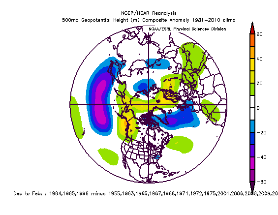
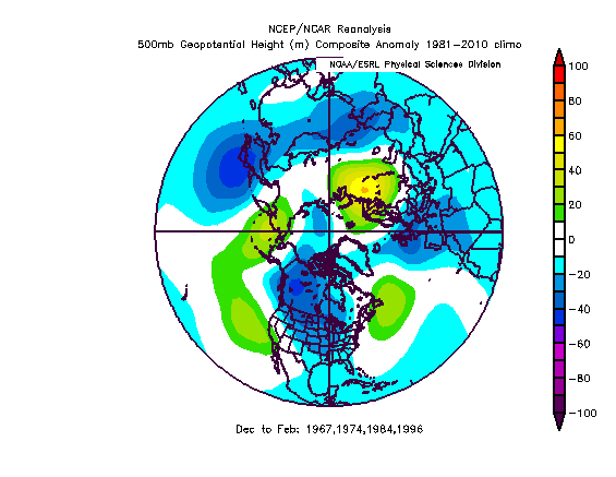
Is the difference as strong? No, not quite; but it’s still there in western North America and the Arctic. It’s interesting to note that the signal for an Aleutian low and SE US trough are features more typically seen with El Nino winters; +PDO and El Nino years tend to go together more often than +PDO and La Nina winters. This is just an anomaly difference map between +PDO La Nina winters and –PDO La Nina winters, here is what the actual anomaly map for +PDO La Nina winters (cool neutral to moderate La Nina) looks like:

This shows that the +PDO cool neutral to moderate La Nina winters don’t have an El Nino like pattern, with an Aleutian/N. Pac ridge, but the difference map shows that ridging extends farther east into western North America in +PDO cool neutral to moderate La Nina winters than in –PDO ones. Although again I doubt the warm waters in the NE Pac in +PDO winters do much to force the large scale pattern, there may be some positive feedback with the ridge that La Nina forcing typically puts in the northern Pac anyways. The north Pacific is still very warm right now, so although the +PDO has weakened some, this modest positive feedback with the La Nina ridge needs to be kept in mind this winter.
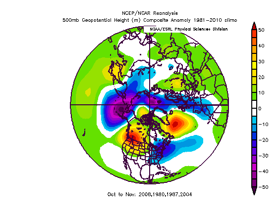
La Nina Winters Following Big El Nino Events
Strong to “Super” El Nino events add a lot of heat to the atmosphere, which can conceivably have an impact on the following winter, even if there’s a flip to La Nina. Although I have more than 20 years in this sample, which means I can’t run the difference maps, I’m going to compare La Ninas (of any strength) following strong or super El Nino events to all other La Nina events (of any strength).
La Nina events following Big El Ninos:
Other La Nina Events:

It is worth noting the small sample of La Nina events following big El Nino events, and also worth noting that La Ninas of all intensity were included in these composites. The most significant difference seems to be more variability in the north Pacific/Aleutian high, but again this may be due to the smaller sample of post strong El Nino La Nina winters. In the post Nino winters there’s a more coherent signal for a +WPO and either weaker north Pacific ridge or at least a lack of a consistent signal in that area. There’s more poleward positive 500mb anomalies in the post Nino years, which would argue perhaps for more arctic air spilling into North America, but negative anomalies also extend off the west coast of Canada, which normally isn’t a cold look for the central/especially eastern US.
Again, I’m not sure if this altered north Pacific signal is due to the varying intensities of the La Ninas included or perhaps the small sample size for post strong El Nino event La Nina winters, but it’s something small that I’ll consider when I draw my final maps.
High Latitudes
Large upper level ridges in the high latitudes that cause the jet stream to buckle, called high latitude blocks, can have a significant impact on temperature and precipitation patterns in the mid-latitudes during winter. Where/if these blocks occur is largely driven by the state of the stratosphere, tropical forcing, and terrain in the mid to high latitudes.
The QBO

The QBO…or Quasi-biennial Oscillation…is a stratospheric phenomenon over the tropics, with a “positive” or westerly QBO featuring westerly wind anomalies in the stratosphere over the tropics…while a “negative” or easterly QBO features the opposite. Normally the QBO has a period of 26 to 30 months, which would’ve put the winter of 16-17 in line to be a vaunted negative QBO winter. However, as you can see on the 30mb and 50mb winds above, after easterly winds began descending in early 2016, they just stopped, with westerly winds resuming in the 30-50mb level where the QBO is typically measured. This appears to be nearly unprecedented, although a very recent paper suggests that the very strong El Nino may have forced the QBO to go back to westerly/positive when it appeared to be trending towards easterly/negative as expected.
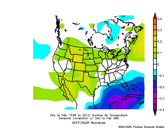
The possible impacts on this winter are less than clear cut; normally, westerly QBOs feature a stronger stratospheric polar vortex, making it harder for stratospheric warming events to occur. Because the stratosphere and troposphere often couple during the winter months over the Northern Hemisphere, a stronger strat PV that is harder to weaken can lead to a more positive winter AO; on the other hand, sudden stratospheric warming events that weaken the stratospheric polar vortex and often lead to a period of strong –AO in the winter occur more frequently in an easterly QBO. Stratospheric warming events have occurred in westerly QBO winters, but are more frequent when the sun is active. Sunspot numbers have been decreasing as we head towards the next solar min, but geomagnetic activity has remained somewhat higher. With all of this said, a –QBO/quiet sun combo is the best bet for a period of significant high latitude blocking in winter, but tropospheric influences are still very important, as the QBO’s correlation to DFJ temperatures in the CONUS is fairly weak:
With that said, due to the influence of the QBO on possible high latitude blocking, it is still important to try to guess how it may influence this winter. Last winter featured strong and frequent attacks on the stratospheric PV, however the strong +QBO and ++ENSO ultimately allowed the PV to remain intact until it was too late; this essentially ruined my February forecast. Although reliable QBO data only goes back until 1979, I’m going to see if La Nina winters with a +QBO have any noticeable difference with La Nina winters with a –QBO. To increase the sample size, winters that had a tri-monthly ENSO value of -0.5C but weren’t officially a La Nina due to duration issues were included. Winters that featured a QBO flip during one of the winter months were not included:
The +QBO La Nina years tended to feature more active convection near the Pacific Maritimes, and also over South America, with no coherent signal over the ENSO regions. There is a notable signal for less convection over the Indian Ocean. At a glance, this would perhaps focus a stronger jet over eastern Asia and perhaps over the northern Atlantic. The strength of the Ninas in the +QBO set was: 2 strong and 2 weak. The strength of the Ninas in the –QBO set was: 1 strong, 2 moderate, and 4 weak; the sample for +QBO is small, but there is a variance in intensity here.

The 250mb zonal wind difference doesn’t show the stronger Asian-Pacific jet that I expected; it in fact shows a weakened one, with a slightly stronger sub-tropical jet over the Atlantic. The 500mb difference is certainly interesting:
The +QBO La Nina winters actually feature a much stronger and farther higher latitude north Pacific ridge, with the AO averaging somewhat more negative, along with lower heights from central Canada to the northern Mid-Atlantic states. I’m not sure what exactly causes a much more amplified north Pacific ridge in +QBO La Ninas compared to –QBO La Ninas; it may be small sample size noise (although I doubt it with anomalies of that magnitude), it may be the stronger strat polar vortex coupling with the troposphere and combining with the La Nina forcing to just put a ridge there. I still personally feel I struggle the most with how the stratosphere couples with the troposphere and influences the winter weather pattern so I can only speculate so much, but that’s still a significant signal.
Weak Fall Polar Vortex:
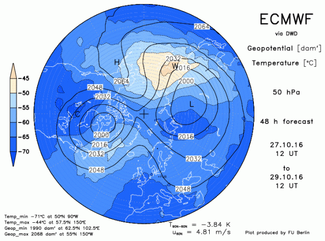
Unlike last year, when the stratospheric PV was compact, strong, and rearing to go during the fall, the current strat PV is splitting…in October. That’s right, after refusing to split last winter, it’s splitting in October, in a +QBO when the vortex is supposed to be stronger. This split appears to be caused by a prolonged and very deep Aleutian low, which favors strong upward momentum transfer into the stratosphere. A complete vortex split this early appears essentially unprecedented since 1980; however, since then, there have been a few other October/November periods that have featured much weaker strat PVs than normal, per 50mb zonal winds in October and November. Here is how the following winters played out, with double weighting to the falls that had the weakest PVs:

It is worth noting, that in this sample, there were…El Ninos: 3 La Ninas: 5 Neutral: 2…and westerly QBO: 4 and Easterly QBO: 6. So, all sorts of different things, many of them not like this winter (La Nina and westerly QBO). However, in the winters that featured weak fall PVs, on the mean, the winter PV was also weak, which tends to favor a –AO in the winter. The ONLY year here that sort of matches this winter since 1980 was 2008-09; the PV stayed weak that winter, but the winter AO averaged very close to neutral. To broaden the sample a bit, here are the +QBO winters following weak PV October/Novembers:
On the mean, these winters actually featured a resurgent strat PV, although perhaps it was displaced a bit from the pole towards North America. The 500mb pattern featured some blockiness and probably a slightly negative AO overall, and hints of a –NAO (although not in the preferred position for the eastern US). Given the small sample size of +QBO winters that started with a weak fall PV, and only one such La Nina winter, it is tough to determine what, if anything, the weak fall PV means. On average, when including the –QBO years, it tends to lead to a weak winter PV…but the +QBO years tell a different story, and given the current +QBO years I’m worried the PV may try to re-strengthen into winter and not help the prospects at significant blocking. On the flip size, the October-November pattern over the high latitudes in those four years was considerably different than the pattern we are seeing this year; this year’s pattern will feature will above average temperatures and also heights over the Arctic (lots of blocking on the mean in October and most likely November this year), the four +QBO years that had a weak fall strat PV on the mean did NOT have above average temperatures and heights over the Arctic:
These years did feature a strong Aleutian low, much like this Fall, but had many differences in the high latitude pattern…meaning that the small sample size of other very weak fall stratospheric PVs, in either +QBO or La Nina years, makes it hard to get a read on the situation and hard to find good analogs.
Eurasian Snow Advance:

Dr. Judah Cohen has become very well known for his theory that fast October snowcover advance in Eurasia, particularly south of 60N, leads to a winter weather pattern more conducive for upward momentum transfer and warming into the stratosphere and for a weak stratospheric vortex, and eventually a –AO in the winter months. The correlation for this index have taken a hit the last few winters, particularly last winter, however it should still be a high enough correlation that it’s worth examining when also examined with other factors that may influence high latitude blocking in the winter months.

The theory states that the more expansive snowcover allows for a stronger Siberian high, which amplifies the jet in a way that favors upward wave propagation into the stratosphere and keeps the strat PV weaker. The snow advance this October in Eurasia has been extensive, and will be one of the top snow advance Octobers since reliable records of snow cover began. In a vacuum, this does suggest a heightened potential for a weaker strat PV and a more negative AO in the troposphere this winter; there are other mixed signals as discussed above, however.
October Pattern Precursor:
A relatively recent paper (http://onlinelibrary.wiley.com/doi/10.1002/joc.3968/abstract) has found that a certain October weather pattern tends to proceed –AO DJF periods; the most notable aspects were anomalously high surface pressure over Siberia/particularly near the Taymyr Peninsula, along with anomalously low SLPs south of Greenland and also south of Alaska. Right now, this October appears to be a match, especially over Russia. The paper specifically discusses a correlation between 700mb height anomalies and the inverted DJF AO between 70-80N and 90E-120E; higher heights in this box in October tend to correlate to a –DJF AO; here are those anomalies this year, through October 26:

The paper claims a correlation of 58% from 1958-2012, meaning that the October pattern allegedly explains 58% of the variability in the DJF AO; meaning it’s useful, but not perfect. The TCA (this) and SAI (snow cover) theories took their lumps last winter, especially the SAI, but both have a half decent correlation over time, and both appear to be strongly pointing towards a –AO this DJF; if they fail again, it would be a big hit for them.
Pattern This Fall:

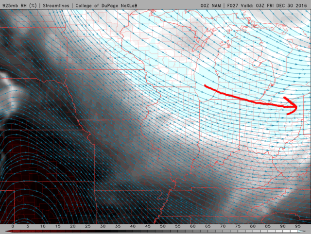
A very deep Aleutian low is developing currently and is expected to remain quite strong through at least mid-November. There may be some relaxation late in the month, if you believe the European weeklies (both the current version and the parallel/soon to be upgrade version), however it appears that the strong negative anomalies built up in this area through the first half of the month will not be wiped out by any weakening of the Aleutian low in late November…in addition, this implies a very warm first 15-20 days of November in much of North America, with perhaps some transient shots of colder air becoming more possible after the 20th. Regardless…an Aleutian low is more of an El Nino thing, so its presence is a bit surprising. This, combined with the ongoing rain in California (!!) suggests that La Nina forcing may not be overwhelming the pattern at this present time.

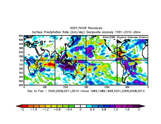
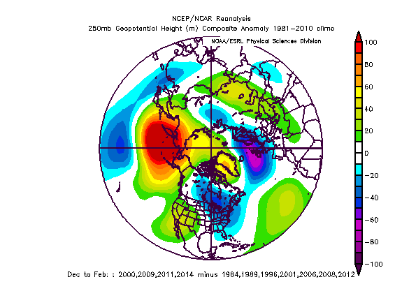
In addition, October featured a strong –AO, mainly due to ridging north of Russia, and November is expected to feature a decent –AO as well for much of the month. I looked through previous cold neutral ENSO or La Nina falls to find other falls that featured an anomalous Aleutian Low and/or –AO in a cold ENSO state…I removed the strong La Nina year that made it in:

Not many cold ENSO winters had a similar pattern to what is playing out this fall…years that were closest were double weighted. The Aleutian Low on the mean does go away these winters, but the AO isn’t very negative on the mean and the cold tends to dump into the western US. Note that only a few of these years had a October-November –AO, and none of them appeared to be as negative as this year’s. Many of these years also don’t match trends noted in +QBO La Nina, +AMO La Nina, and +PDO La Nina; it will be interesting to see if the Aleutian low is replaced by an Aleutian high late those trends try to suggest.
Analogs:
Due to this winter appearing to be a fairly unique set of variables at play, I’m not sure how useful the analog method will be…however, I do use analogs to help time the possible pattern and also determine the possible magnitude of anomalies up against the research I just laid out above. I don’t think any one analog is particularly great. They are:
54-55, 83-84, 95-96, 13-14
Putting it all Together:
The tropical SSTA profile suggests tropical forcing will be most active near the Pacific Maritimes and perhaps over South America into the Atlantic, and least active over the Indian Ocean and Pacific east of the Dateline; this will support a stronger than normal jet over eastern Asia breaking over the NW Pacific, favoring ridging over the Aleutians. La Nina winters in a +QBO, although few, tend to support a more robust ridge over the Aleutians. The PDO should remain positive this winter, although not as positive as the last couple; +PDO La Ninas tend to be associated with a more extended Asian-Pacific jet (contrary to the +QBO years), with the ridging being located farther east, closer to the Gulf of Alaska, with more pronounced troughing in the Midwest and Northeast (centered in the Midwest). The AMO should remain positive, which in a La Nina tends to re-enforce the influences of the +PDO.
The Fall pattern appears to be one conducive for further blocking in the winter due to a weakened stratospheric polar vortex, however the +QBO typically leads to the opposite occurring more frequently. With that said, the current potentially record weak stratospheric PV and potential for that vortex to remain under attack, due to a strong Aleutian low in November which tends to promote upward momentum transfer into the stratosphere, does cast some doubt as to the future of the strat PV and winter AO. Another La Nina/+QBO Fall that featured a weak strat PV (08-09) saw the PV remain weak during winter, but the AO that winter was weakly positive on average. Lots of mixed signals here, although I tend to lean towards the winter AO being negative on average.
The analog years I selected suggest December being the warmest month overall, the coldest month being January, followed by a slight relaxation in February (but not as warm as December). With that said, only one analog (83-84) was reasonably close to the October pattern and expected November pattern, and had the coldest month as December. An assortment of La Nina years that I played with and ran through tended to also have January as their coldest month, but had December as the second coldest month and February as the “warmest.” With the current lack of cold across North America I’m not sure how frigid December may or may not be, and it may depend on how much improvement the Pacific sees in late December, but I will differ from my 4 “analogs” in that area.
There is a lot of uncertainty this year due to some conflicting signals, but some signals did resonate with each other, such as a signal for more robust northern Pacific ridging and perhaps a –AO winter overall; the fall pattern is unusual and the combination of factors is still unusual, so this forecast represents what I think the evidence points towards being most likely, but is not high confidence.