September 7th, 2018: Gordon Remnants to Bring Flooding Concerns to Ohio

rain 9-7 final

The remnants of Tropical Storm Gordon will move across the southern Great Lakes as a non-tropical low-pressure this weekend.  This will combine with a front, the jet stream, and lingering tropical moisture to wring out quite a bit of rain across a good portion of Ohio.  The potential exists for some areas to get heavy rain, which will cause flooding concerns.  Here’s the quick summary:

-There will be some rain today and tonight in southern and central Ohio, though except for perhaps localized issues close to the Indiana boarder this won’t be the heaviest portion of the event

-Rain will gradually become more widespread and heavy as Saturday afternoon wears on

-The heaviest rain will likely start in western Ohio late Saturday and gradually work east-northeast through the state through Sunday evening.  Northeast Ohio won’t get into the heavier rain potential until late Saturday night or Sunday morning

-Except for a few localized exceptions, much of the state hasn’t been that wet lately and can generally handle some rainfall without flooding.  The concern will be for prolonged tropical downpours that may cause flash flooding later this weekend where they occur, and also in areas that do see several inches of rain, which will likely be enough to cause river flooding concerns despite the recent dry conditions

-Embedded areas of heavy rain and thunder will ultimately drive the heavier totals.  This will be inherently a little bit inconsistent.  I expect most areas to get a good amount of rain, but only areas that get hardest will see the upper end of these totals


9-7 NAM 1.png

Modeled fronts, low to mid-level flow, and atmospheric moisture valid Sunday AM


The non-tropical area of low pressure associated with the remnants of Gordon will move northeast across the southern Great Lakes Sunday into early Monday, bringing periods of heavy rain to Ohio as the lift from that low pressure, the fronts, and the jet stream interact with the tropical moisture being drawn north.

I can’t rule out a few slow-moving downpours/storms with locally heavy rain mainly in far west-central or southwestern Ohio this Friday afternoon/evening, but the meat of this heavy rain event doesn’t really start taking shape until Saturday afternoon…


9-7 NAM 2.png

Model forecast mid-level winds and temperatures/humidity valid late Saturday PM


This will start occurring when the low to mid-level flow starts increasing across the Ohio Valley.  This will essentially cause moisture to get squeezed/wrung out by the front into central and southern Ohio.


9-7 NAM 3

Model forecast mid-level winds and temperature/humidity valid early Sunday


As the low intensifies and slowly moves northeast Saturday night into Sunday, the lift along the front in the low to mid-levels will also get stronger, making heavy rain more likely.  This process will only slowly shift north, so the concern is for some areas to get at least a few hours of moderate to heavy rain with decent rainfall rates Saturday night into Sunday as the warm frontal zone slowly lifts across the state.

The warm front likely gets close to Lake Erie by Sunday afternoon, so a round of heavier rain is likely well into northern Ohio, though it will probably take into late Saturday night or Sunday morning to get there.

Aside from the heavy rain from the warm frontal lift, the cold/occluded front will slowly move west to east across Ohio Sunday into Sunday evening, sparking more locally heavy rain/storms that may not be short-lived in some spots:


9-7 NAM 4.png

Modeled fronts, low to mid-level winds, and atmospheric moisture Sunday afternoon


The occluded front will slowly move across the state Sunday into Sunday night, and with the highest moisture being just ahead of this front and storm motions being nearly parallel to the front, some training rain/storms with heavy rainfall rates will be a concern Sunday into Sunday night as the occluded front moves slowly east across Ohio.

Some instability will gradually build north Saturday night into Sunday, and be maximized Sunday into Sunday night ahead of the occluded front the pushes east.  The instability won’t be that strong, but will enhanced the potential for embedded heavy downpours:


9-7 NAM 5

Model forecast instability valid overnight Saturday night


9-7 NAM 6

Modeled instability valid late Sunday afternoon


In addition, the upper-level winds will be in a favorable, diverging pattern both Saturday night into Sunday morning as the warm-frontal rain is lifting north, and Sunday evening as the occluded front pushes east:


9-7 NAM 7

Forecast upper-level winds valid late Saturday night/early Sunday morning


9-7 NAM 8.png

Forecast upper-level winds valid Sunday evening


This will also further increase the potential for widespread rain with embedded moderate to heavy rain…

Essentially, many factors are aligning for heavy rain later Saturday through Sunday night…

-Strong lift from warm front slowly lifting across state

-Additional lift moving across the state shortly thereafter as the occluded front pushes east

-Large-scale upward motion due to favorable jet stream dynamics as both above processes occur

-A warm, very moist airmass that will promote heavy precipitation rates

-Weak instability, which will enhanced the potential for embedded heavy rain.

Weak instability in a warm, very humid airmass with multiple sources of lift is about the best way to maximize potential rainfall rates.  Embedded heavier rain/thunder could produce rain rates in excess of 1” per hour at times, and much of the state will see multiple opportunities of at least a few hours for heavy rain.  The rain will be inherently a little inconsistent because it’s summer, but where the stars align there will be several inches of rain.


9-7 recent rain.png

Observed rainfall percent of normal over the last 14 days


Over the last two weeks, rain has generally been at or a bit below normal across most of Ohio.  A few big exceptions, and those areas will be more vulnerable this weekend, but in general rivers aren’t running that high going in and the ground isn’t too saturated…so we can take some rain.  However, prolonged heavy rates would still cause flash flooding, and several inches over a large area will overwhelm and flood some rivers, so the risk for flooding is certainly elevated this weekend, and those in flood prone areas should be prepared for the potential.  River flooding, flash flooding of streams and creeks, and roadway flooding will all be concerns given the potential for heavy rates and high amounts over a large area.

Posted in Uncategorized | Leave a comment

September 6th, 2018: All Eyes Now on Florence

Disclaimer: The thoughts in this post are only mine and don’t represent the thoughts of any other companies, groups, websites, or organizations.  They also shouldn’t be used for decision making in the impacted areas…

The majority of the satellite and model images in this post are courtesy of Tropical Tidbits.  Any poorly drawn illustrations on the images are my own.

Now the post…

Key takeaways at this point:

  • Florence is unlikely to take the early recurve out to sea this weekend, meaning it will get into the western Atlantic and put Bermuda on guard during the first half of next week…and the East Coast on guard starting around Wednesday.
  • Whether or not Florence actually manages to hit the East Coast directly or recurves out to sea with much more minor, indirect impacts is impossible to determine at this point, as it will come down to finer-scale details that can’t be accurately forecasted at nearly a week out. At this point it should be stressed that less than half of all available, reliable guidance actually directly hits the coast, but that most data does at least get it close with a smaller portion actually hitting directly.  The threat is there, but nothing is a given this early.
  • Florence has weakened dramatically over the last 12-18 hours and further weakening is expected into the first half of the weekend.
  • Re-intensification, quite possibly back into a major hurricane for a time, is likely as we head into early next week as Florence tracks into the western Atlantic.


Florence IR

Current satellite imagery of Florence


Hurricane Florence basically did everything I said it wouldn’t do over the last couple of days.  It defied a marginal environment and intensified rapidly, to at one point a category 4 hurricane in an unusual location that far north in the eastern Atlantic, and also stayed on the northern side of the envelope of possible forecast tracks over the last couple of days.  Why it intensified despite expected moderate shear, dry air, and marginal water temps (SSTs) is a little bit beyond me…it’s possible the storm itself was able to create a small bubble of little shear in its immediate vicinity or that some sort of internal dynamics fought off the shear for a couple of days.

The above satellite image is much less impressive than what we were seeing yesterday…Florence is exhibiting a smaller area of deep convection (with warmer cloud tops), with no discernable eye or eyewall on convectional imagery.  The center is located near the southwestern edge of this deeper convection, with outflow still good in the northern and eastern quadrants but very restricted/missing in the southern and western quadrants.


Florence shear

Current analysis of wind shear across the Atlantic showing 30-40 knots of shear over Florence


We appear to be at the point where whatever mechanism that was fighting off the shear has finally been overwhelmed, as 30-40 knots of westerly/southwesterly shear have clearly had an effect overnight.  The storm will end up weakening from a category 4 to a category 2 in the matter of 18 hours by the time the 11AM EDT advisory comes out.  Florence will be tracking through this belt of strong west/southwest shear for another couple of days, and further weakening is likely.


Florence SAL

Current analysis of the “Saharan Air Layer” (dry air), with the layer showing up in yellows/reds


It does not help matters that Florence is still in proximity to some mid-level dry air courtesy of a Saharan Air Layer.  The west/southwest shear will tilt Florence’s circulation to the east/northeast with height, making it more prone to dry air entrainment than it’s been.  Shear won’t abate until somewhere around Saturday, and don’t be surprised at how much another full day or two of strong shear/dry air entrainment can weaken Florence (considering it’s already weakened quite a bit)…this very well could be a tropical storm by the time conditions start becoming more favorable for it to strengthen again over the weekend.


Florence GFS 90

GFS model forecast upper-level winds valid Sunday evening


Florence is expected to move north of the belt of inhospitable upper-level conditions by Sunday and into early next week.  Ironically, the weak upper-level disturbances shearing it now may end up acting as outflow channels that help intensify the hurricane into early next week as it tracks into the western Atlantic.  The jet stream to the north could also help with ventilating the hurricane in the upper-levels.


Florence SSTs.png

Current SSTs across the Atlantic basin


Florence will also be moving over increasingly warm SSTs over the next several days, considerably warmer than what it was over on Wednesday as a category 4.  This, combined with the expected favorable upper-level wind pattern, will likely foster re-intensification into early next week…likely back into a major hurricane.


Florence GFS sounding

GFS model forecast sounding for the environment surrounding Florence on Monday.  The plot shows winds with height on the right, and temperature/humidity in the middle.  The red line is temperature, green line is humidity.  The gap between the two represents some dry air.


This is still a kind of delicate situation, as forecast soundings show dry air continuing to be perhaps somewhat of a hindrance to intensification into early next week…500-850mb RH is 70% on this storm-averaged sounding from the GFS, which is on the margins of being unfavorable.  If shear is in fact weak (less than 10 knots) as the GFS and Euro both show, this won’t be a significant issue, but if shear fails to weaken below about 10 knots, then dry air intrusions would slow re-intensification.  At this point I suspect that given the favorable SSTs that once Florence moves north of the strongest shear over the weekend that the strong outflow will favor deep convection over the center that allows it to intensify pretty quickly…but, we’ll need to see exactly how much of a toll the next couple days of unfavorable conditions has on the storm.

Long story short on the intensity, expect continued weakening (potentially rapid) through Friday and into Saturday before re-intensification.  How quickly it re-intensifies is up in the air, but there appear to be enough “positives” for intensification that Florence will be a hurricane and likely at times a major hurricane again over the western Atlantic early next week.

As for the track forecast…


Florence historical tracks

Track of all tropical storms or hurricanes on record that have tracked within 100 nautical miles of Florence’s Thursday morning position


The first comment is that we should keep in mind the historic precedent…no storm that has tracked within 100 miles of Florence’s 5AM Thursday location as a tropical storm or hurricane has struck the US.  So, we’d need an unusual pattern to see that happen here…it does appear we’ll have that.


Florence current steering

Current steering flow across the Atlantic Ocean (Thursday morning)


In the short term, Florence will likely start slowing some to end the week and into the weekend and turning more “left” or back towards the WNW (instead of the recent NW heading) as ridging builds in to its north.  Florence will be weakening over the next day or two as mentioned above, and this will make it more prone to getting shunned to the left by the ridge to its north.


Florence EPS 72

European ensemble mean upper-level weeather pattern valid Saturday evening


As we head into the weekend Florence’s initial opportunity to recurve comes up on us for Saturday night-Sunday as a weakness in the ridging briefly opens up to the north of the storm.  For a number of reasons, a recurve at this juncture now looks less likely that it did a couple of days ago:

  • The trough to the north does not dig as far south, resulting in the ridging breaking down later, less, and building back in quicker
  • Florence will be moving rather slowly (note the random, and not particularly strong steering currents ahead of Florence), and may not gain much latitude before ridging builds back in
  • Despite Florence’s unexpected intensity this week, it’s expected to be near the pinnacle of its weakening trend when this weakness in the ridging briefly opens up. Florence being weak when its brief escape hatch is open decreases its chances of taking it.


Florence EPS 96

European ensemble mean upper-level weather pattern valid Sunday evening


The weakness in the ridging north of Florence closes quickly, within a day, as the trough over the north Atlantic quickly zips off to the east-northeast and ridging builds back in.  Given all of the reasons mentioned above, Florence likely doesn’t get to hit the weakness in the ridging before it closes, which would force it to turn back more to the west into the western Atlantic as what will likely be an intensifying hurricane.


Florence EPS 144

European model ensemble mean upper-level weather pattern valid Tuesday evening


As has been the fear all along here, if Florence misses the early recurve (now expected), the anomalously strong ridging over the western Atlantic would force Florence to move west to dangerously  near the US East Coast.  That is still expected, and Florence will in all likelihood make at least a dangerously close approach during the second half of next week.

Whether or not Florence gets close, but then turns away, or is able to make landfall is still unknown and may ultimately come down to finer details that just can’t be resolved at this range.


Florence GEFS 144

American model ensemble mean upper-level weather pattern valid Tuesday evening


For instance, the GFS ensemble (American model) has a little bit less riding over the western Atlantic, which would make the “close call” scenario more likely than the European solution, which has a stronger ridge and makes a direct landfall more likely.


Florence GEFS trend

Trends in the upper-level weather pattern among the last several runs of the “American” model ensemble


With that said, even the GFS ensemble has had some concerning trends over the last several runs…towards a stronger ridge over the western Atlantic, and perhaps a bit of a trough over the southern US, which could not only help intensify the ridge but also perhaps pull the storm west if located in the correct location…many East Coast hurricane hits have some sort of trough over the Ohio or Tennessee Valley that helps pull a storm more north-northwest instead of letting it just curve around a ridge.


Florence EPS tracks

Wednesday night’s European ensemble member track forecasts for Florence, showing a wide spread of possible solutions


Last night’s European ensemble has continued the trend of the last few cycles of going from just a small cluster of members getting Florence into the western Atlantic to nearly every member missing the early recurve and getting the storm into the western Atlantic.  A little less than half the members actually hit the US directly, but that’s still up from previous runs, and even most of the misses are just off the coast and close enough for at least indirect impacts (dangerous surf, beach erosion).

The big takeaways at this point are that Florence is likely getting into the western Atlantic, putting Bermuda and the East Coast on guard.  It’s still simply too early to tell if this will directly hit the coast or simply curve away just off the coast with more minimal impacts.

Factors that could make a hit more likely would be the upper-level trough over the southern US coming in a bit deeper, perhaps pulling the storm more west as it rounds the western edge of the ridge.  The ridge itself being stronger or located farther west would also inherently force Florence to track farther west, increasing the risk for an actual landfall.

A weaker ridge overall, or the ridge being located just a bit farther east, would make the “near miss” scenario more likely to pan out.

Ultimately it’s too early to know any of these details, at this point we just know that some sort of threat is there for the second half of next week for the US East Coast (and Bermuda during the first half of the week).  The ridge’s location would likely make a direct hit on the Long Island/New England area harder to come by…I think if this hits the US directly it more likely does so in the Mid Atlantic or Carolinas.

Posted in Uncategorized | Leave a comment

September 2, 2018: Tropics heating up just in time for peak season

Disclaimer: The thoughts in this post are only mine and don’t represent the thoughts of any other companies, groups, websites, or organizations.  They also shouldn’t be used for decision making in the impacted areas…

The majority of the satellite and model images in this post are courtesy of Tropical Tidbits or weathermodels.com.  Any poorly drawn illustrations on the images are my own.

Now, the post…

The Atlantic hurricane season was rumored to be a quiet one in the spring and early summer…that’s largely been the case thus far.  With that said, even quiet seasons usually have some hurricanes and maybe a major hurricane or two, and it looks like this season’s window for more substantial activity is coming up over the next 2-3 weeks…right on schedule compared to the climatological peak of the Atlantic hurricane season:


9-2 climo

Number of Atlantic hurricanes and tropical storms by date, showing the typical peak of the season around September 10th


This expected burst of activity is due to a large-scale weather pattern favoring upward motion and storminess of the Atlantic coinciding with an active African Wave Train (the latter is pretty common for this time of year).


9-2 MJO ECM

Ensemble forecast for the MJO phase over the next two weeks from the European ensemble


The large-scale pattern is called the “Madden Julian Oscillation” or MJO, and is basically areas of enhanced lift and thunderstorms near the Equator the move around the globe and impact both tropical cyclone development and the jet stream in the mid-latitudes.  The MJO has been forecast consistently by our recent modelling to move into phases 8 and 1 in the week 1-2 timeframe (see above image), which climatologically correlates to upward motion over the Atlantic:


9-2 MJO 200

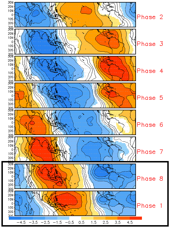
Composites of upper-level vertical motion for each MJO phase in the early fall


Blues indicate large-scale upward motion, favored over the Tropical Atlantic in a phase 8 or 1 MJO…forecast models also show this general upward motion over the next couple of weeks:


9-2 MJO GFS

Forecast upper-level vertical motion from the GFS model for the next two weeks


The lack of yellows/browns over the Atlantic is a general departure from most of this hurricane season so far, and indicates neutral or even upward motion in the greens compared to normal for this time of year.  This generally favorable regime for tropical development is coming with a couple of systems of note already over the Atlantic, and more lined up over Africa:


9-2 Atlantic IR

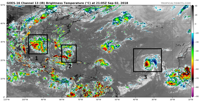
Current infrared satellite imagery across the Atlantic


9-2 Africa IR

Ditto for Africa


Out of the systems currently over the Atlantic, 1 won’t develop but is already producing some flash flooding along the Gulf Coast, 2 will likely develop into at least a tropical storm before making landfall along the northern Gulf Coast later this week, and 3 is Tropical Storm Florence, which won’t bother anyone for a while but could eventually…


9-2 7 vis

Visibile satellite imagery of Potential Tropical Cyclone 7


The system in the Bahamas (Potential Tropical Cyclone 7 or PTC 7) is the most immediate threat to the US as it moves across the Keys/southern Florida tonight into Monday and into the Gulf for Tuesday, before landfall somewhere along the northern Gulf Coast late Tuesday night or Wednesday.

This system is noticeably more organized today, with a clear mid-level circulation with convection that is still bursting a little bit rotating around it.  Some modest anti-cyclonic outflow has also become evident in most quadrants.  There’s no surface circulation yet so it’s not a tropical cyclone as of this afternoon, but there’s a pretty good chance one develops tonight or Monday with the next burst of convection given the current organization.


9-2 7 shear

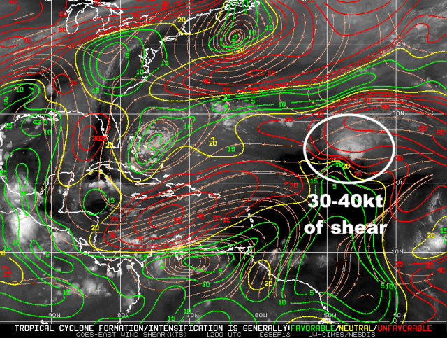
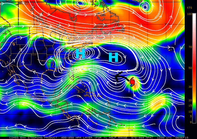
Vertical wind shear analysis for the western Atlantic valid Sunday morning


PTC 7 is within an area of modest westerly wind shear; note how the outflow isn’t yet present in the western quadrant, likely due to this shear.  This shear is not strong enough to stop development from occurring in the near term.  There is a belt of stronger shear in front of the disturbance over the eastern Gulf of Mexico between an upper-low off the Carolinas and upper-level anticyclone near the Texas coast….however, the upper-level low is expected to drift northwest and the anticyclone to the west over the next couple of days, allowing PTC 7’s anticyclone and weaker shear to maintain as it moves into the eastern Gulf…


9-2 GFS 48

GFS model forecast upper-level winds valid Tuesday morning over the western Atlantic


This low-shear environment will combine with very warm water temperatures with moderate oceanic heat content to favor intensification through Tuesday evening while the system is over water:


9-2 w atl ssts

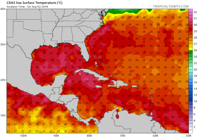
Current Sea Surface Temperatures in the western Atlantic (in Celcius)


The water temperatures starting tonight and early Monday as the system moves near the Keys and then through expected landfall Tuesday night in the vicinity of Louisiana are on either side of 30C (86F), which are easily warm enough to support robust tropical development.  Oceanic heat content is a little bit more moderate in the northern Gulf continental shelf waters, but still can support a stronger system than what PTC 7 will turn into…this isn’t a limiting factor.


9-2 7 sounding

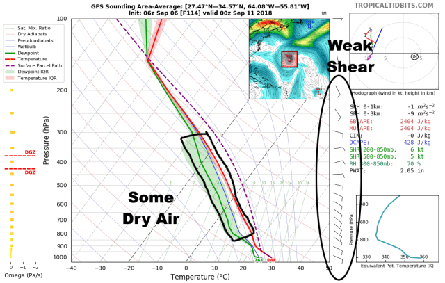
GFS model forecast sounding for the environment around PTC 7 on Tuesday


If there is a limiting factor for PTC 7’s intensification over the Gulf (other than time), it appears to be some dry air.  Shear and water temps aren’t limiting factors, with less than 10 knots of shear on area-averaged forecast soundings around the cyclone…but, some dry air and perhaps a bit of asymmetry with the system may ultimately limit the potential for more rapid intensification.  PTC 7 should become a tropical storm (likely Gordon) at some point on Monday, giving it 24-36 hours to intensify further.  Intensification into a category 1 hurricane is easily within the realm of possibility here, but it would require the cyclone to mix out the dry air and become a bit more symmetrical.  Even in a generally favorable environment this can take a day or two…I suspect PTC 7 (likely Gordon) will be on an intensifying trend on the way in, but it’ll be making landfall right around when it may be able to become a hurricane.


9-2 EPS 48

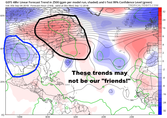
European ensemble mean 500mb heights and anomalies valid Tuesday AM


PTC 7 will be steered by a ridge over the Mid-Atlantic towards the west-northwest through the middle of the week.  The ridge is expected to build back west near landfall , which may cause the system to move rather slowly just inland west through Louisiana and into Texas.  This slow movement will ultimately cause the greatest concern with PTC 7 to become flooding, even if it can become a hurricane and bring some damaging winds, storm surge, and power outages as well.

As for Florence…


9-2 Florence IR

Infrared satellite imagery of Florence


Florence is not currently a well-organized tropical storm.  Convection has been very bursty and asymmetric, with the center circulation near the southwestern edge of the bulk of the convection.  There is some anticyclonic outflow evident, but it’s non-existent in the western quadrants.  This is due to moderate westerly shear affecting the storm.  There’s also drier/stable air to the north and west of the cyclone (evidenced by the low stratus clouds visible on the satellite image above), with the shear entraining that into the circulation.  Florence is also moving over very marginal water temperatures.  Long story short, don’t expect much intensification in the short term.


9-2 ECM 84 shear.png

European model forecast deep-layer wind shear over the Atlantic valid late Wednesday


Florence will be moving headlong into a pretty solid belt of moderate to at times shear for the next few days (generally 15-30 kt over the storm for the next 4 days).  This, combined with the aforementioned dry air, and this:


9-2 SSTs ATL

Sea surface temperatues across the Atlantic (C)


Just don’t support much (if any) intensification through Wednesday or Thursday at least.  It’s probably not impossible we see Florence up into an open wave at some point as the Euro tries to show.  Once Florence gets north of the belt of stronger shear and over warmer SSTs towards Friday or the weekend, that’s when more substantial intensification could occur…though the status of the storm at that point is not quite certain, as the cyclone opening up into an open wave would complicate things.


9-2 GFS 700 48

GFS model mid-level winds, heights, and humidity vaild Tuesday


Over the next few days Florence will be steered towards the west-northwest by the low to mid-level flow south of ridging across the eastern Atlantic.  Florence is already fairly far north and will likely pass safely north of the Lesser Antilles around the end of this week.  The GFS, HWRF, GFS ensembles and Canadian models have a more northwesterly track over the next few days while the Euro and UKMET are farther south and more of a WNW heading.  Given questions over how much Florence can intensify, if at all, over the next few days, I’m inclined to think that the NHC forecast (which is a split between the two camps as per usual) will be too far north by days 4-5.

The track farther west is as always uncertain at this time range, with several different things that could happen…


9-2 EPS 168

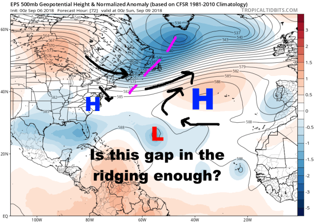
European ensemble mean 500mb pattern valid September 9th


The first big fork in the road comes next weekend.  Florence will approach a weakness between ridging over the eastern Atlantic and strengthening ridging over the western Atlantic along the East Coast.  There will be a trough moving across the north Atlantic at this time, but it doesn’t penetrate very far south due to the building ridging over the western Atlantic.

Does Florence recurve at this point?  Does it kind of stall or slow, but ultimately keep going west as the ridge over the western Atlantic intensifies and becomes dominant?

Too early to say, unfortunately.  It will probably slow down considerably for 2-3 days starting around Friday.  A stronger storm prrrobably gains enough latitude here to eventually recurve, but a weaker storm may get trapped under the intensifying ridge to the west.  As mentioned above, it’s too early to speculate how intense the storm may be next weekend.  Conditions will probably become more favorable for intensification near the end of this week into next weekend, but if Florence is an open wave at that point it may not get strong enough quickly enough to recurve.  Normally this scenario would be a recurve with Florence already being so far north as far east as it currently is, with a break in ridging in the middle of the Atlantic, but the ridging intensifying to the west as Florence gets there along with Florence’s intensify not yet being known in 5-7 days adds at least a layer of intrigue.


9-2 MJO lagged

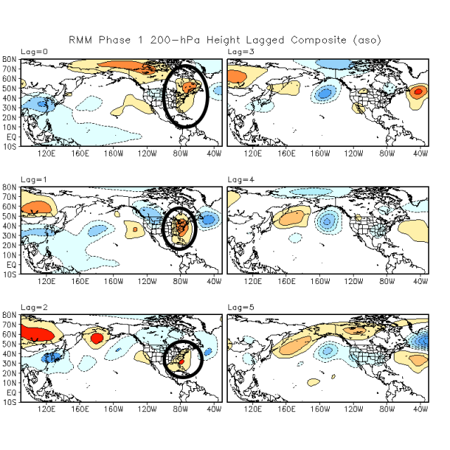
Lagged composite 200mb height anomalies for a phase 1 MJO in the fall


Interestingly, the all-important MJO even favors ridging along the US East Coast in phases 8-1 (phase 1 shown) in the August-September-October timeframe…though also note that a few days later in a phase 1 MJO that the ridge tends to be replaced by a trough over the east (blue colors on the day 4-5 lags).


9-2 EPS 216

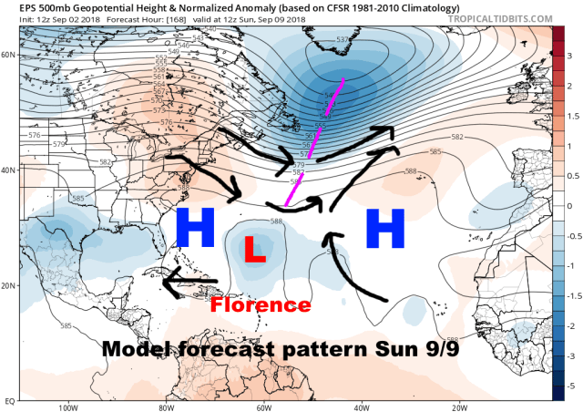
European ensemble mean forecast 500mb heights valid September 11th


Essentially, all evidence suggests there will be an unusually strong ridge over the western Atlantic in the 7-10 day timeframe that would cause Florence to resume a WNW motion into the western Atlantic IF it doesn’t recurve through the weakness in the ridging in the central Atlantic around days 5-7.


9-2 EPS 240

Ditto valid a day later


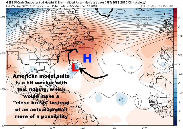
Even then, IF Florence does make it into the western Atlantic, the ridging is progged to be centered off the East Coast with some hints at ripples in the jet stream that could perhaps erode the western side of the ridge.  This could potentially allow for a close brush instead of an actual hit on the East Coast (or the ridge could be a little stronger and allow for a hit, these are too fine of details to try to be guessing at 10 days out).


9-2 EPS Florence

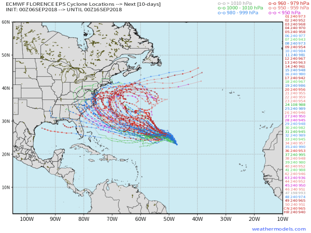
European ensemble member forecast tracks for Florence


The European ensembles bare this out…some members do take the early recurve, though more do get farther west…but many then still manage to recurve out to sea, just closer to the East Coast.  Several members do have tracks that could eventually hit, so it’s worth watching, but right now that camp is decidedly smaller than the camp that finds a way to curve Florence out to sea before getting all that close to the US coastline.

Long story short on Florence, we don’t know if it will recurve over the central Atlantic in 6 or 7 days…recurve over the western Atlantic later…or miss all of those opportunities and actually threaten the US East Coast.  There are more ways this recurves than hits in my opinion, and that’s usually the case with storms coming from this far east, however, the unusually strong ridge over the western Atlantic and uncertainties with Florence’s intensity forecast don’t make a total miss a complete given yet.

Behind Florence…

There could be a couple of more waves to watch for development before this generally favorable pattern for tropical cyclone development over the Atlantic winds down after the middle of September.  The ridging over the Atlantic continues to look stronger than normal through the next two weeks, so we’ll have to keep an eye on anything that can develop…though as is always the case, it should be noted that the standard climo for African waves that manage to develop over the open Atlantic is for recurve to be favored until told otherwise…so though the pattern will continue to warrant some watching, let’s take each storm one at a time and not get too worked up this early on.

Posted in Uncategorized | Leave a comment

Severe Weather Risk in Ohio for Tuesday April 3, 2018

SPC 2.png

Categorical Severe Weather Outlook for Tuesday and Tuesday night from the Storm Prediction Center issued Monday afternoon

severe threats 4-3.png

Threat levels for the individual severe hazards for Tuesday-Tuesday evening across Ohio

We literally just wrapped up a winter storm that dropped up to 6” of snow on parts of Ohio 12 hours before this writing.  Now we have to turn around and discuss a fairly interesting severe weather threat for tomorrow.  Spring is quite a bitch in Ohio, ain’t it?

WPC surface

Forecast weather map valid 8:00PM Tuesday

This severe weather threat is being driven by a fairly strong area of low pressure that will track over extreme northwest Ohio Tuesday evening.  This will push a warm front through much of the state during the morning and afternoon on Tuesday with one potential round of storms.  A cold front will sweep through during the evening with a second and likely more potent round of storms.

ROUND 1: STORMS NORTH OF THE WARM FRONT EARLY TUESDAY:

HRRR18.png

Model forecast radar valid 8AM Tuesday

Storms are expected to flare-up north of the warm front late tonight and Tuesday morning.  Much of the state will probably see some rain and perhaps some thunder Tuesday morning, but the most robust storms will likely be south of I-70.  A quick 1-2” of rain may cause some flooding concerns with this round of storms in parts of central and southern Ohio.  A few stronger storms may also produce some hail.

NAM 24 theta.png

Model forecast mid-level temperature/moisture and wind valid 8AM Tuesday

This round of storms will be triggered by a surge of mid-level warmth and humidity that will ride up and over the surface warm front Tuesday morning.  This will cause the unstable air to rise and generate thunderstorms, and is a classic way to get storms just on the “cold side” of a warm front.  Most models show the storms and the conceptual model fits what the models show, so I’m inclined to expect a pretty good round of storms early Tuesday across southern and perhaps central Ohio.

NAM 24 cape

Model forecast instability and wind shear valid 8AM Tuesday

There will be a fair amount of instability aloft and wind shear feeding into the early-day storms on Tuesday.  Because of this, some stronger storms with hail will be a concern across southern and central Ohio early Tuesday.  This isn’t really the meat of the severe threat, but given the ingredients in place early Tuesday, don’t be surprised if a few severe thunderstorm warnings are issued for quarter sized hail south of I-70 Tuesday morning.

ROUND 2: STORMS ALONG AND AHEAD OF THE COLD FRONT LATE TUESDAY-TUESDAY EVENING:

NMM33.png

Model forecast radar valid 5PM Tuesday

After perhaps a lull early Tuesday afternoon, more storms will either develop or move in during the mid to late afternoon.  We will watch for two areas of storms: a few storms potentially developing well ahead of the cold front over parts of Ohio during the mid afternoon to early evening timeframe, and then more widespread storms developing to our west closer to the cold front and sweeping across the state during the evening.

NMM38.png

Model forecast radar valid 10PM Tuesday

The most widespread storms are expected to push across the state during the evening hours on Tuesday along and just ahead of the cold front.  The storms will have their highest severe risk across parts of western and central Ohio, with a gradual weakening as they track farther east during the evening and head into some weaker instability.

All modes of severe weather will be at least somewhat possible with this second round of storms.  I will address the environment for both the potential storms ahead of the front during the mid-afternoon to early evening timeframe and then the storms along the front itself during the evening.

POTENTIAL PRE-FRONTAL STORMS:

NAM 30 CAPE

Model forecast instability valid 8PM Tuesday

There is some uncertainty regarding exactly how unstable we get by late Tuesday afternoon and evening, as it’s possible that the early rain and storms are stubborn to move out and keep some sort of a lid on things.  Most guidance clears this early activity early enough to develop a moderate amount of instability by mid to late afternoon, so for now that’s the idea I’ll go with.  If this idea works out, instability or a lack thereof won’t be a limiting factor Tuesday afternoon and evening for any storms ahead of the front or along it.

NAM 30 srf.png

Model forecast low-level wind shear valid 8PM Tuesday

Thanks to the strong low pressure in the region, winds throughout the atmosphere will be fairly strong and will turn enough to generate a fair amount of wind shear.  While the low-level shear values don’t necessarily max out the color scale in Ohio Tuesday afternoon and evening, values of over 150 are considered sufficient for rotating storms and an elevated tornado threat.  All of Ohio looks to see values near or safely over that threshold, so though there could be some more shear, it also isn’t going to be a limiting factor for the severe threat.

NAM 27 lapse.png

Model forecast mid-level temperature change rate valid 5PM Tuesday

Another factor, in addition to raw instability, is how quickly temperatures cool in the mid-levels of the atmosphere.  This determines how sustained any taller thunderstorms may be, and also the hail threat.  We’re again not maxing out the scale here, but values of this index (called “lapse rates”) are high enough to support deeper thunderstorms and an elevated risk for large hail with any individual storms ahead of the cold front Tuesday afternoon and early evening.

If individual storms can develop and sustain themselves ahead of the cold front in this moderate instability and moderate to strong wind shear environment, they would have a threat for large hail, strong winds, and even tornadoes.  Will they fire?  That’s sort of up in the air.

NAM3 CINH.png

Model forecast cap strength valid 5PM Tuesday

There will only be a weak cap ahead of the cold front.  This means it will be fairly easy for storms to fire in this environment.  IF the early day storms don’t linger and keep temperatures cooler, it appears that a cap won’t limit any storm development ahead of the cold front.

NAM 30 conv

Model forecast low-level lift valid 8PM Tuesday

Even with the weak cap, we still need a little bit of “oomph” to get storms to go ahead of the front.  The forcing along the front is clearly strong, ahead of the front it’s non-zero but also fairly weak.  My hunch is this may allow isolated storms to go ahead of the front late Tuesday afternoon and evening.

NAM 30 250.png

Model forecast upper-level winds valid 8PM Tuesday

The upper-level flow will be broadly divergent over Ohio, with a favorable quadrant of a “jet streak” (region of stronger winds in the jet stream) for large-scale lift also near Ohio.  This, along with the weak cap and weak but non-zero low-level forcing ahead of the front, should be enough for some isolated storms ahead of the cold front mid Tuesday afternoon through early evening.  The weak nature of the low-level forcing may keep the storms isolated and discrete, potentially increasing the threat for them to turn severe with some large hail and perhaps produce tornadoes.  With that said, the low-level forcing is weak, and if temperatures a bit cooler at the surface then the cap will be stronger, so this is still a conditional threat for rotating/severe storms.  But, I see enough ingredients in place to tentatively raise some alarms.

AS FOR STORMS ON THE FRONT:


NAM 33 cape.png

Model forecast instability and cap strength valid 11PM Tuesday


Strong forcing along the front will force storms to fire over Indiana late Tuesday afternoon and move into western Ohio by early evening.  Favorable parameters as discussed above will be in place as the storms hit western Ohio, meaning some will likely be severe.  These storms will not be “discrete,” but will be messier and perhaps organized into lines.  This will tend to limit the potential for large hail and tornadoes, but may increase the potential for damaging winds.  So, the expectation is a somewhat organized line of storms will get into western Ohio between 6pm and 9pm with mainly a damaging wind threat…though isolated hail and a spin-up tornado can’t be ruled out due to the amount of instability and low-level wind shear in place.

As the storms move east, low-level temperatures will slowly cool through the evening, causing instability to slowly weaken and causing the cap to slowly re-develop.  This will cause the storms to slowly weaken as they head east across Ohio, though an isolated severe storm or two with mainly a damaging wind threat may make it all the way into eastern Ohio given the strong lift with the front and wind shear in place.

All in all, we have a fairly dynamic setup for Tuesday and Tuesday evening, though how storms ahead of the front play out will determine the ultimate threat.  The early-day storms will modulate future instability…they need to clear quickly enough for a substantial threat later in the day.  That’s currently the expected outcome, but it’s never a given.  Whether or not isolated storms develop ahead of the front with a severe risk is a bit uncertain, and a messy storm mode with storms along the cold front itself may put somewhat of a lid on that threat.  Regardless, given the ingredients in place, locations in the risk area from the Storm Prediction Center in Ohio will need to have their eye on the weather Tuesday into Tuesday night.

Posted in Uncategorized | Leave a comment

Quick Meteorological Discussion on Tonight’s Snow (and a map)

3-19 snow 2

Here’s my final bid on this…do suspect there will be some unforeseen screw holes, but am hoping they’re few and far enough in between…

The low is expected to be a little farther west than was thought yesterday, which brings marginal temps and a dry slot farther in from the south/east into south-central, southeastern, and east-central Ohio for a good chunk of time this evening into the night. This really eats into the area I thought would see the best snow in east-central Ohio yesterday, and that represents the largest change from yesterday’s forecast. There may be a sharper cutoff from good snows just west of Columbus to dry slot and only an inch or two farther east than expected, which is one area that may end up getting shafted compared to this map depending on how quickly the dry slot fills after midnight.

Within the broad band of light snow expected to develop from southwestern and west-central to central, north-central, and northeastern Ohio by late this evening there will be a couple of areas to watch for better snows. The first will be across parts of west-central Ohio where a TROWAL will advect into the shield of snow for several hours this evening. The better moisture/lift and instability with this feature should cause a period of moderate snow where it hits the deformation/cold conveyor belt snow. Forecast soundings show decent lift within the DGZ, so once it cools enough for snow and accumulates ratios may actually be higher than 10:1. With a good upslope flow into the higher terrain in west-central OH potentially aligning with the better snow, along with slightly colder temps in the higher elevations, think that if any area sees a number of 6″+ reports it’s there…so did highlight that with 5-7″ within the larger 3-6″ area.

The other area to watch will be across the northern portions of the shield of precip, where some modest low to mid-level fgen is likely to squeeze out a band of snow that’s at times moderate. This area also shows decent lift in the DGZ on soundings from the NAM, GFS, and RAP, so again once it starts snowing and sticking ratios may actually give a bit of a boost. There are still hints that an area of higher theta-e air in the low and mid-levels will advect into this area of fgen early Wednesday in extreme eastern Ohio and get pinched off, possibly causing a few hours of better snow. Because of this, did keep a 3-6″ area in extreme east-central Ohio, though that’s not the highest of confidence.

Suspect there will be some areas that don’t do great between the better snow from the TROWAL in west-central OH and better snow from the fgen in northern OH, but its kind of hard to guess where. Areas between the better lift will still see several hours of snow, so I’m still hoping they can see 3-4″ of snow…but suspect some spots won’t quite get there. Did go conservative on the northern edge in NE OH downwind of the higher terrain, due to already dry NE winds downsloping off of the higher terrain in the Snowbelt into the east side of Cleveland and areas NE of Akron.

Think south-central and SE Ohio see an inch or so late tonight into early Wednesday as the CCB/deform snow collapses SE as the low fills and jumps to the East Coast. With marginal temps, mainly light rates, and shorter duration am not expecting more than an inch, maybe two inches on the hilltops, in this portion of Ohio.

Posted in Uncategorized | Leave a comment

More Accumulating Snow Downwind of Lake Erie Through Wednesday Morning

3-13 NEO

3-13 snow OH

General discussion (scroll down for technical thoughts):

Snow showers will generally diminish tonight as they move east across Ohio. An exception will be downwind of Lake Erie, where some light accumulations may occur.

Snow showers will ramp up Tuesday state-wide, with brief but intense snow showers possible, especially during the afternoon and evening. The best shot for some light accumulations during the day Tuesday will be in the higher terrain from north-central Ohio east through northeast Ohio, though in most cases any quick snow accumulations from the snow showers will melt between snow showers. The most likely exception may be the Snowbelt in northeast Ohio due to some lake enhancement in the morning that could drop up to a couple of inches. The concern during the day Tuesday will be brief periods of significantly reduced visibility and snowy roads with the heavier snow showers causing hazardous travel conditions.

As the sun goes down Tuesday evening any lingering intense snow showers may have a better shot at producing a quick accumulation anywhere in the state. Lingering moisture on roads may freeze. A burst of heavy lake effect snow is expected Tuesday evening, producing a quick 1-3″ of accumulation in both the primary and secondary Snowbelt, including the Cleveland area. This may create a period of hazardous travel during or just after the evening commute.

After perhaps a brief lull late Tuesday evening, another increase in lake enhanced snow may occur late Tuesday night into Wednesday morning in northeast Ohio. Depending on how heavy this burst of snow is, it may adversely impact the Wednesday morning commute from Cleveland and perhaps Akron points east before the snow winds down by noon Wednesday.

Technical discussion:

Complicated setup over the next couple of days, but there will be rounds of snow with accumulations likely.

A shortwave/weak surface low going by this afternoon is causing some flurries and light snow with no real accumulations with temps above freezing.  Tonight this wave and lift pull off to the east, but a relatively unstable airmass currently over lower MI/IN/NW OH will drift east across the lake tonight.  Though the snow showers over lower MI are largely diurnally driven, the steep low-level lapse rates and good moisture will slide east.  Mixing over the low to mid 30s water of Lake Erie should cause this airmass to produce light to briefly moderate lake effect snow showers this evening into tonight across parts of NE OH and NW PA as the corridor of moist/unstable low-level air slides east.  The RAP forecast soundings have good moisture/lapse rates up to 7-8k feet at CLE as this airmass moves overhead this evening with NW winds.  The NAM soundings are drier/more stable, but have generally found that an airmass that produces widespread diurnal snow showers overland will produce some lake response as the diurnal snow showers over land decrease.  With a NW flow expect the higher terrain from the secondary Snowbelt south of CLE east across the primary NE OH Snowbelt and interior NW PA to have the best shot at some accumulations tonight.  Duration of favorable conditions is only a few hours in any given area and organization doesn’t look great, but the layer of instability appears deep enough for moderate bursts.  Tend to think a dusting to up to an inch or inch and a half is likely tonight downwind of the lake, with the best shot at around an inch or so in the higher terrain.

Perhaps a brief lull late tonight before the next potent shortwave/vort max passes late Tuesday morning.  The strongest lift from this vort max may track a little southwest of the Cleveland area and NE OH, however, some increased lift along with a lobe of upstream moisture and the layer of instability deepening to over 10k feet should allow for a decent period of snow showers Tuesday morning with this feature.  Some models take the upstream moisture towards the central highlands in this period, but with a NW or NNW flow I don’t buy the Lake Huron moisture moving that far southwest.  Think it will affect the Cleveland area and perhaps secondary Snowbelt, and the rest of NE OH.  The best snow in this period may miss NW PA to the west, but some increase is possible in this area.  Some bursts could put down a quick inch or two of snow Tuesday morning downwind of Lake Erie in NE OH as the vort max goes by, however, again a lack of organization and fairly short duration, along with known difficulties accumulating during the day this late on the year, hard to get excited about much more.  Outside of the Snowbelt, expect to see diurnal snow showers that are briefly heavy pop up.  Best shot at some light accumulations outside of the lake effect may be in the central highlands where upslope may focus snow showers a bit more and where temps will be a couple of degrees cooler.  Anyone could see a quick/likely brief dusting though Tuesday as the snow showers ramp up overland.

Any more organized LES by Tuesday afternoon will likely break up, however, with remarkably cold 500mb temps of around -40C expect numerous convective snow showers to continue across much of the state Tuesday afternoon.  The snow showers will be briefly heavy and may quickly produce a dusting where they track.  In the higher terrain, there may be somewhat better odds at enough snow showers during the afternoon for a little additional accumulation, though normally this time of year any accumulations from these convective snow showers melt pretty quickly between showers.  Temps outside of perhaps the higher terrain in north-central and northeastern OH/NW PA where it will be close to freezing will be in the mid to upper 30s between snow showers.  The main concern with the diurnal convective snow showers will be visibility reductions and perhaps briefly slick roads.

A sharp surface trough drops across the lake into north-central and NE OH Tuesday evening.  The models have shown this feature for several runs and it appears to be tied to a vort max at 700mb rotating around the western edge of the trough.  The vort max may cause a further intensification of the diurnal snow showers late Tuesday afternoon from western OH to SE OH, and as the sun goes down any lingering intense snow showers could drop a quick half inch or inch before weakening overnight with the loss of daytime heating.  The big concern will remain significant visibility reductions and brief slick roads.   Downwind of Lake Erie, the sharp surface trough when combined with soundings showing instability and moisture to over 13k feet will likely result in a brief but intense period of squalls during the evening.  Moisture from Lake Huron again looks to work into NE OH with this feature.  Some global models bring the Lake Huron moisture towards Mansfield again in this timeframe, but with a NW to NNW flow will again side with the hi-res NAM and RGEM that drop the Lake Huron moisture into the Cleveland area and surrounding Snowbelts.  With this burst occurring near or after sundown it should accumulate downwind of Lake Erie.  The best may again be in NE OH as opposed to NW PA in this timeframe given closer proximity to the mid-level vort max and track of the upstream moisture.  Organization (lack thereof) and short duration will probably limit amounts, but given the very deep instability and sharp nature of the trough, a quick dusting to locally 3” is possible downwind of Lake Erie Tuesday evening, especially in the higher terrain where it’ll be a little colder and where precip amounts will be maximized.  This may cause a period of hazardous travel conditions.

Another little shortwave/spoke of synoptic moisture/lift drops through Wednesday morning.  Some disagreement to how far west this gets.  NW PA looks like a good bet, and many models do at least hit the primary NE OH Snowbelt.  Cleveland area is iffier, though the 18z NAM and RGEM do get a burst of snow as far west as the secondary Snowbelt.  With decent looking snow ratios, a favorable WNW to NW upslope flow, duration of perhaps several hours in NW PA, and enough low-level instability for decent lake enhancement, this may produce decent accumulations.  Snow rates of an inch per hour may occur in the higher terrain.  Will expect 3-6” in interior NW PA, 2-4” in the higher terrain in the primary NE OH Snowbelt, and 1-2” in the higher terrain of the secondary NE OH Snowbelt late Tuesday night-Wednesday morning.  This is all dependent on how far west the lobe of synoptic moisture/lift gets, which is uncertain.  Adjustments up or down are possible.  Should be a decent lull Wednesday afternoon through early Thursday between systems.

For total accums…in the higher terrain in the primary NE OH Snowbelt, am going around 1” tonight, 0.5-2” Tuesday morning, less than 0.5” Tuesday afternoon, 1-3” Tuesday evening, and 2-4” late Tuesday night/Wednesday morning for 4.5-10.5” (will call it 4-8” for now).  Some melting may occur during the day Tuesday between snow showers.  In the secondary Snowbelt am figuring 0.5 to 1” tonight, 0.5-2” Tuesday morning, less than 0.5” Tuesday afternoon, 1-3” Tuesday evening, and 1-2” late Tuesday night/Wednesday morning for about 3-6” total.  For NW PA am thinking 4-8” in the higher terrain, as the snow through Tuesday evening may not be that impressive there, but that will likely be made up for late Tuesday night/early Wednesday.  Some models have more QPF there Wednesday morning, so that will have to be watched.  Will also drag 1-3” into the central highlands and also the rest of NE OH south of the Snowbelt due to decent bursts of snow working south from the lake, especially Tuesday evening.  Do think all of OH is at risk for some quick bursts of snow producing a dusting Tuesday into Tuesday evening.  With a short fetch off the lake and milder temps near the water, am expected a good bit less snow near the lakeshore than in the higher terrain inland.

The period between late Tuesday PM and Wednesday AM may prompt some advisories in NW PA and perhaps the higher terrain of the NE OH Snowbelts.  If the wetter solutions pan out for early Wednesday inland Erie County could flirt with needing a warning.

Posted in Uncategorized | Leave a comment

Additional Snowfall Through Friday Morning

snow

After some unexpectedly heavy lake effect snow last night, more snow moves in this afternoon and evening.  The snow will be heavy at times from the Cleveland metro points east through the Snowbelt later this afternoon through this evening, before winding down by noon Friday.  This evening commute and Friday morning’s commute may be impacted in some areas…

Short technical thoughts:

The forecast upper-low and surface low track have shifted east since Wednesday morning’s model runs, which results in the best shot of synoptic lift and snow occurring mainly across the primary NE OH Snowbelt, and also increases the snow a bit for NW PA.  This has resulting in some reduction on the southern and western sides from yesterday.  Forecast amounts for this leg of the event in the primary Snowbelt remain similar, but this map doesn’t reflect last night’s lake effect and only shows additional snow.

For some specifics, obs and radar support snow rates probably maxing out around 1”/hour in eastern lower MI this morning.  Given a good shot of lift from positive vorticity advection beneath a fairly potent vort max, low to mid-level frontogenesis, and low-level convergence, along with some enhancement from Lake Erie, still think we’re on track to see snow ramp back up this afternoon and peak late afternoon through the evening, with rates of 1-2” per hour still possible at times where the better organized areas of low-level convergence and lake enhancement occur.  Model soundings still show steep lapse rates and moisture to around 500mb for quite a while later this afternoon and this evening in NE OH, with decent snow growth as well until late tonight when the better mid-level support diminishes.

Wasn’t expecting the lake effect to be so organized and far south still, but think as winds turn SW over the lake over the next few hours that may still try to lift north for a time.  If not, it’s beginning to get enhanced by synoptic moisture and will put down additional accums until it lifts north (assuming it ever does).

Given a few hours of potentially heavy rates in the primary Snowbelt and getting into the Cleveland area, with some light snow before and also after lingering into Friday morning, think 6-10” of additional snow is still doable.  The snow may diminish for a few hours late tonight and briefly re-intensify Friday morning with a shortwave going by, some lake induced instability, and a flow around 280 degrees, but am only figuring an additional 1-3” Friday morning from Cuyahoga County points north/east.  Lowered amounts a bit in the secondary Snowbelt, but still have 3-6” there.  Winds only get up to 280 to 290 degrees later tonight which can get a band into that area, but it’s a little iffier now and the synoptic snow will be lighter there than initially thought.  Even so, still think they see a 15 or so hour window for snow that’s moderate at times and fairly high ratio, so think several inches will still be possible.  This isn’t a good setup for the lakeshore, so aside from the eastern lakeshore where some lake effect snow is still ongoing this morning am not expecting more than 1-4” along the shore.  Went a little on the higher end of model guidance down towards Akron and Youngstown.  The flow not gaining as much of a northerly component makes it iffier down that way, but the synoptic snow will still push SE this evening and they may still see some lake enhancement, so was nervous to go less than 2-4” for that corridor.  Interior NW PA has a better shot at 4-8” of snow tonight through Friday AM with a better burst of synoptic snow this evening than thought yesterday.

Posted in Uncategorized | Leave a comment

3/7/18: More Snow Through Friday Downwind of Lake Erie

snow 3-7 NEO

Technical Discussion:

A flare-up of snow is beginning to occur as of this writing (4:30PM), with an area of light synoptic snow moving across Lake Erie and grazing the lakeshore.  There may be a bit of lake enhancement of this snow, with some moderate bursts possible.  This will pull east pretty quickly by early to mid-evening, but may drop less than an inch in NE OH east of Cleveland and perhaps a quick 1-2” in Erie County, PA.  Behind this wave of synoptic moisture driven by some weak mid-level deformation lake effect conditions will improve this evening.  Winds will be fairly well aligned at 275-285 in the lowest several thousand feet, with steep lapse rates and good moisture up to 9-10k feet.  In addition, a disorganized area of numerous snow showers from Lake Michigan will move east across Lake Erie into the central lakeshore and NE OH Snowbelt this evening for a few hours, providing good pre-conditioning.  A little 700mb vort max will also move across the lakeshore counties providing for some upward motion below 700mb.  Given all of these generally favorable conditions, some bursts of decent snow are possible from Lorain County (and perhaps extreme northern Medina and Summit Counties) points east this evening mainly between 7pm and midnight.  After midnight, winds back a bit and start pushing the Lake Michigan moisture and lake effect up the shore into the northern primary Snowbelt in NE OH and into NW PA.  Some sinking motion behind the 700mb vort max and a bit of drying in the mid-levels will likely cause the lake effect to become less intense after midnight, though I’d imagine some snow showers will continue in the northern Snowbelt overnight and into early Thursday.  Increasing convergence early Thursday morning may focus a weak band across the lakeshore from Lake County northeast through Erie County, PA.

All in all, I don’t think the lake effect will be organized or long-lasting enough for a big accum tonight, but I’ve seen these types of setup (deep instability/good pre-seeding, with fairly light winds) produce pretty impressive bursts of snow that can drop an inch or two in an hour or less.  Snow growth isn’t optimal, with some lift in the DGZ this evening but the best lift below it.  This may result in some graupel at times and ratios not much above 10:1.  So, I think I’ll go with a general 1-3” from parts of Lorain County and the Cleveland metro points east.  If a better convergence band can organized into extreme NE OH or NW PA near the lake later tonight, that may allow for some 3-4” amounts, especially since those areas may see a little more from the brief shot of synoptic snow this evening.

The lake effect should briefly lift out over the lake for everyone in OH and PA Thursday morning as winds turn SWrly.  Synoptic snow will increase Thursday afternoon and peak late afternoon and early evening as a number of things happen.  A compact surface low will drop SE across eastern Lake Erie during the late afternoon and early evening.  The low will likely open up by evening, but will cause a sharp trough and broadly cyclonic and convergent low-level flow on the back-side of it that will push inland off the lake during the late afternoon.  There will also be some low to mid-level frontogenesis along the aforementioned trough axis west of the low as some modified Atlantic air wraps all the way around the storm and comes in from the north.  In addition, there will be a very strong vort max with the closed 500mb low that will drop right into the Cleveland area.  All of these sources of lift…along with steep lapse rates and deep moisture up to around 500mb due to 500mb temps of colder than -35C…will cause moderate to heavy snow.  It wouldn’t shock me if there was some lightning along any stronger convergence-driven bands of heavier snow given the deep layer of steep lapse rates.  Given the deep layer of instability, some lake enhancement, and multiple sources of decent lift, snow rates may hit 2-3” per hour late Thursday afternoon and evening for brief periods with any better bands of snow focused by low-level convergence.

Am thinking the best period of snow will last about 3 hours in any given area, but may coincide pretty well with the Thursday PM commute and may quickly but down 2-5” of snow in 3 hours, locally more if there are some well-defined bands.  Temps will be right near freezing, but good snow growth and heavy rates should allow for ratios a bit higher than 10:1 despite the somewhat milder surface temps.  Right near the lake may sit a little bit above freezing which may slow accums a bit near the lake, but if it snows hard it will accumulate.  There may be some snow showers for a few hours ahead of the best burst that may produce an inch or so, especially in the higher terrain.

There is some disagreement with the exact low track, with some models trying to take the low a little farther west and drop the best snow west of Cleveland.  I tend to think the low will hug the relatively warmer waters of Lake Huron and Lake Erie and stay on the eastern side of guidance.  The more consistent models such as the Euro ensembles, UKMET, Canadian, and hi-res NAM since last night agree on the best snow going into the Cleveland metro and NE OH Snowbelt.  NW PA should see a burst in the evening, but the best will likely be in NE OH.  My forecast is based on the premise that the best snows with the system Thursday late afternoon and evening will be from the Cleveland metro east, but mainly west of NW PA.

Behind the potentially furious burst late Thursday, some lighter snow will linger Thursday night into Friday morning.  Some mid-level isentropic lift could keep patchy light synoptic snow going, as modified Atlantic air continues to ride up the core of the colder air with the upper-level low pulling away to the ESE.  This, along with 850mb temps around -10C and plenty of low-level moisture, along with a WNW flow, will keep light to moderate snow going in the Snowbelt.  The flow may remain somewhat convergent behind the low for the rest of Thursday evening, perhaps allowing for some corridors of more organized snow.  Also will have to watch the zone from Lorain and Medina Counties east across the southern NE OH Snowbelt, as a flow around 290 or so often focused some convergence in that corridor that may keep moderate snow going for a longer period of time.

One last shortwave moves through late Friday morning/early afternoon, which may keep some light to locally moderate lake effect/enhanced snow going until about noon.  Winds look 280-290, so the snow will likely be focused from Cuyahoga County (and perhaps northern Lorain and extreme northern Summit) points north/east Friday morning, with the heaviest in the higher terrain where good low-level moisture will continue to promote orographic enhancement.

In terms of total accums…thinking 1-3” tonight (locally 3-4” extreme NE OH into parts of Erie Co)…and then a general 4-8” Thursday afternoon through Thursday night in the primary NE OH Snowbelt, with 3-6” in the secondary Snowbelt and probably 2-5” in NW PA.  If any persistent areas of convergence linger in NE OH, some locally higher amounts may occur Thursday night.  Expect another 1-3” Friday morning from Cuyahoga County and perhaps extreme northern Lorain/Summit points north-east.  Snow showers will continue into Friday evening but will add up to little additional accumulation.  This gives totals of about 5-10” in NW PA (best shot at 10” in the higher terrain of Erie County)…about 6-14” in the higher terrain of the NE OH Snowbelt (will call it 7-13” to trim the range a bit)…and a good half foot or so for parts of the secondary Snowbelt south of Cleveland.  Will drop amounts off to the southwest, though much of northern OH could see some light accumulations from the synoptic snow.

Here’s my map at this point, which includes the snow falling now.

Posted in Uncategorized | Leave a comment

February 22, 2018: Major Flooding Expected This Weekend Across Parts of Ohio


TAKE HOME MESSAGES:

  • All of Ohio is vulnerable to heavy rain and flooding through this weekend due to the recent wet weather
  • The heaviest rain recently, and coming up, will likely be across parts of central and southern Ohio
  • Widespread and significant flooding is expected across parts of central and southern Ohio this weekend
  • At least minor issues are expected farther north in the state

flood watch

A FLOOD WATCH has been issued for all of southern and parts of central Ohio through the first half of this weekend.  In the watch area flooding, that may be widespread and significant, is expected.  North of the watch area, at least minor issues are possible.  This flood threat is a culmination of a recent wet weather pattern that’s already produced some flooding and additional heavy rain falling this weekend on already saturated grounds and already high streams and rivers.

WHAT WE’VE ALREADY SEEN:


observed rain

Observed rainfall between 7am on Thursday, February 15th and 7am Thursday, February 22nd


Essentially all of Ohio has seen over two inches of rain over the last week, with some portions of extreme southern and extreme eastern Ohio seeing over four inches.  Note that some additional rain fell this morning after the cutoff, so some areas have actually seen a little more than this map shows.  This rain has saturated the ground across all of Ohio and already caused its own flooding, with some river flooding across all portions of the state at some point over the last week.  Particularly hard hit have been parts of east-central, southeastern, and southern Ohio, where there have already been two separate widespread flooding episodes and where the Ohio River has already seen a crest in the “moderate flood stage” range at many river gauges.  Rivers in Northwest Ohio also are currently seeing flooding as the very heavy rain over northern Indiana gets into some rivers, such as the Maumee.  Needless to say, we’ve already seen enough rain.

THE WEATHER PATTERN THIS WEEKEND:

NAM PWAT.png

Forecast total atmospheric moisture content (called Total Precipitable Water) compared to average

A prolonged southwesterly flow over the eastern United States will funnel unusually moist air north into the Ohio Valley and Great Lakes through the weekend.  This air is expected to have a moisture content that’s at times over 4 standard deviations above average over Ohio for this time of year, making it a very anomalous and close to record-setting event…and increasing the odds of more heavy rain.

NAM 250

Modelled upper-level winds Saturday night across the eastern US

In addition to all of the moisture moving into the region, we’ll be located beneath a favorable upper-level wind pattern for storminess and precipitation.  Being to the south/southwest of a strong region of jet stream winds, known as a “jet streak,” is known for being active and stormy, as that area relative to a jet streak sees upward motion.  This will promote numerous waves of low pressure and enhanced rain chances moving through the region between late Thursday night and Sunday morning.

TIMING THE HEAVY RAIN:

NAM3 21.png

Model forecast radar and fronts valid 10:00AM Friday

The next round of rain will be late Thursday night and Friday morning as a low pressure tracks into the northern Great Lakes.  This will pull a warm front across Ohio Friday morning, and push a cold front across the state during the afternoon.  This process will cause another round of rain and even some embedded thunder across much of the state.  Rainfall amounts with this round will be about a quarter to half an inch across northern Ohio and a half inch to inch across central and southern Ohio.  This may prolong any ongoing river flooding from recent rain and slow the recession of any other lingering flooding…and could cause some new flooding, especially across central and southern Ohio where they’re most vulnerable and where the heaviest rain is expected to fall.

NAM12 48.png

Model forecast radar and fronts valid 1PM Saturday

The next round of heavy rain will really be a two part hit from one strong low pressure tracking into the northern Great Lakes.  The first part will be a shot of moderate to rain, along with some embedded thunder, ahead of the warm front during the day Saturday.  This may drop a widespread one half to inch and a half of rain across the state late Friday night through Saturday, with locally higher amounts possible if any areas see repeated or “training” heavy rain/thunder.  A relative lull in the rain is possible late Saturday afternoon and early evening, but…

NAM12 60.png

Model forecast radar and fronts valid 1AM Sunday

More rain and storms will move back in late Saturday evening through early Sunday as the cold front approaches and moves through Ohio…bringing another widespread three quarters of an inch to inch and a half of rain to much of the state, with locally higher amounts possible if anyone sees repeated or “training” heavy rain/storms.  This will all cause flood concerns across the state, with both quick “flash” flooding possible when the heaviest storms occur and river flooding after the rain due to the added effects of each shot of rain.

We finally dry out fairly quickly Sunday morning, with no substantial rain expected during the first half of next week.

THE RESULTS:

rain forecast.png

Much of the state will see one to locally four inches of rain this weekend, with the highest amounts likely where any heavy rain/storms repeatedly track.  All of the state is vulnerable to heavy rain and flooding right now, with the areas worst off being parts of central and southern Ohio where the best shot at a few inches of rain is.  Much of the state can expect at least some minor flooding issues through this weekend, with significant issues possible in central and southern Ohio.  We will need to watch the northern edge of the heaviest rain closely, as any adjustment north could bring more significant flooding north of the current flood watch area.

day2 excessive rain

Excessive rainfall outlook for Friday-Friday night from the Weather Prediction Center

day3 excessive rain

Excessive rainfall outlook for Saturday-Saturday night from the Weather Prediction Center

There is currently a slight risk (risk level 2 of 4) for excessive rain and flash flooding across parts of central and southern Ohio for Friday and Friday night from the next round of rain, and a slight to moderate risk (risk levels 2 of 4 and 3 of 4) for central and southern Ohio for Saturday and Saturday night.  There is a marginal risk (risk level 1 of 4) for northern Ohio both time periods.  These outlooks are issued by the National Weather Service’s Weather Prediction Center.

These risks indicate the potential for rain heavy enough to cause flash flooding in a given area in each timeframe.  Flash flooding is when heavy rain causes rapid water rises, typically in urban areas and along smaller creeks and streams.  A moderate risk indicates a 20-50% chance of this occurring, which is substantial.  As discussed above, some flooding may occur from the round late tonight into Friday, but the more substantial rounds look to be Saturday through early Sunday.

river forecast

Forecast river crests at gauges across the region from the Ohio River Forecast Center

In addition to the potential for urban and small stream flooding as the rain is ongoing, the repeated heavy rain over a large area will cause many main stem rivers to rise and potentially flood.  Most larger creeks and rivers are expected to approach or hit flood stage through the weekend in Ohio.  It’s worth noting the flooding on northwest Ohio rivers is mainly from rain that’s already fallen.

Of particular concern is the expectation of a major flood to move down the Ohio River later this weekend into early next week, with crests at moderate to major flood expected all along the Ohio River.  Some gauges may even approach record levels.  Other larger rivers in parts of east-central and southeastern Ohio will also likely flood.

You can monitor real-time river levels and forecasts here:

http://www.weather.gov/ohrfc/

In general, a lot more rain is coming, and this will cause new flooding across the state.  In parts of southern and central Ohio, this flooding may be widespread and significant.  Flash flooding in urban areas and on smaller creeks/streams as the rain is falling, river flooding on larger waterways, and flooding/standing water in any low-lying and/or poor draining areas will all be concerns this weekend.  If you live in a flood prone area and are ordered to evacuate, heed those orders.  Monitor any streams, creeks, and rivers near your location for rises through the weekend.  If you come across a closed or flooded road…many of which are likely…never drive through them.  Remember, turn around, don’t drown!  The good news is next week looks much quieter, giving us a chance to dry out.

Posted in Uncategorized | Leave a comment

January 24, 2018 Long Range Blog: Big Cold Returns in February

Take home messages:

  • Despite brief cooldowns behind storms, much of the eastern US will be mild overall through the end of January.
  • Cold will dive into the central US by the beginning of February, and likely work into the east more consistently during the second week of the month.
  • Signs point towards potential significant cold, perhaps as cold as or colder than what we experienced in early January in some areas.
  • Cold, potentially significant at times, may last for much of the rest of February in the eastern and central US.
  • A winter storm will be possible across the northern Ohio Valley, southern/eastern Great Lakes, and perhaps interior New England during the first few days of February.
  • The pattern may become more supportive for snows, perhaps decent, across more of the east around February 10-15, but some flaws will likely remain in the pattern.

Discussion:

season temps

Temperature departures from normal from December 1-January 22nd, meteorological winter so far

It has been a pretty cold start to winter across the eastern half or so of the country, with significant chunks of the Ohio Valley, Great Lakes, Northeast, and Mid Atlantic running at least a few degrees colder than normal so far for the winter.  A large chunk of this is due to a significant and in some areas record breaking cold snap to start the year.  The current weather pattern has brought some much milder conditions to most of the central and eastern US, a welcome January thaw for many people:

current 500

Current upper-level weather pattern over the Northern Hemisphere

The current pattern does not support much cold over the central or eastern United States, with a +NAO (trough over Greenland/the north Atlantic), -PNA (ridge over the Aleutian Islands and trough near the West Coast), and +EPO (upper low over Alaska) limiting the ability for cold air to move into central and eastern portions of the country.  Instead, Pacific air is dominating, with periods of warm weather broken up by a couple of days of near normal conditions behind any storms moving through.  This pattern will continue for the rest of January…but a change is in the works pretty soon.

EPS 84.png

European ensemble forecast upper-level pattern valid Friday evening

The first step of many of this change back to a colder pattern will begin over the next few days over the northern Pacific.  A strong storm over eastern Russia will cause a large anti-cyclonic wave break over the north-central Pacific between Alaska and Russia, forcing a very amplified ridge in the jet stream to develop over the Bering Sea.  This ridge will break off into a robust blocking ridge and move towards the Pole into next week:

EPS 180

European ensemble forecast upper-level pattern valid evening of Tuesday, January 30th

This blocking ridge will facilitate a prolonged “cross polar flow” into northern Canada, causing a deep reservoir of cold air over Siberia to be tapped and transported into North America.  Siberia is much larger and sees much less marine influence, and therefor tends to be much colder than northern Canada during winter.  This tap of very cold air will cause Canada to become quite cold over the next week or so, with that air ready to drop into the US once the pattern allows:

EPS 850 change

European ensemble forecast temperature departures from normal valid this Thursday morning and next Thursday morning

Before the blocking ridge and cross polar flow develop, Asia features a much larger pool of cold air than North America.  By later next week, a substantial amount of cold has spilled into Canada and is poised to move into the US…the question is, when will it actually get here?

MJO forecast

Madden Julian Oscillation or MJO forecast for the next two weeks

The MJO is a coupling of the atmospheric circulation and thunderstorms in the tropics.  Where the enhanced thunderstorms occur has a significant impact on the large-scale weather pattern across the globe, particularly during winter, as the storms give off large amounts of heat into the upper-levels of the atmosphere and modulate where the jet stream is and how strong it is.  There are well-known correlations between each MJO phase and temperatures across the US:


MJO temps US

Temperature composites for January-February-March for the various MJO phases


We are well into the “warm” phases now, and will be through this week and into next week.  There will be brief cooldowns behind any storms that go by, but overall the temperatures will average out warm over about the next 10 days over much of the central and eastern US.  This matches well with the MJO progression.  Later next week the MJO heads into phase 7, which while typically not cold in the east is not quite as warm, with the implication being the MJO will continue to work into phase 8 and potentially 1 thereafter, both cold phases.  By MJO progression, we can expect a turn to much colder conditions in the central and eastern US by the second week of February.  However, it appears that some big cold will arrive a bit earlier, particularly in the central US…

EPS 240

European ensemble forecast upper-level weather pattern valid Friday, February 2nd

The previously discussed ridge over the north-central Pacific that closes off and moves towards the polar region is expected to pin an upper-level low/trough to its south over the Aleutian Islands later next week, a configuration known as a rex block.  Because both features are expected to be “closed off,” the pattern may be fairly stable for at least a few days.  This trough over the central Pacific is expected to help build up a ridge in the jet stream near the West Coast, causing the PNA to become positive and allowing the frigid air building over Canada to plunge south towards the northern Rockies, Plains, and Midwest by the end of next week.

This initial pattern still isn’t particularly cold for the eastern US due to some lingering SE ridge (encouraged by the MJO progression) and the ridge being centered a bit off the West Coast, so the cold may not plow all the way to the East Coast consistently during the first week of February…but the central part of the country should turn quite cold right around the turn of the month.


EPS 10-15

European ensemble mean upper-level pattern valid February 2nd-February 7th


The ridging over the eastern Pacific towards Alaska is expected to be very persistent into February for a couple of reasons.  The first reason is the persistent vortex from NE Asia to the Aleutians, a feature that’s been common this winter so far, is not going to be displaced anytime soon and will continue to pump up that ridge.  Also, the MJO progressing east towards phase 8 in two weeks and possibly phase 1 in about 3 weeks supports a +PNA (ridge along the West Coast).  Not only does the pattern moving forward seem to support what the models are showing, but the pattern so far this winter looks awfully similar to what’s projected coming up:

500mb winter

Mean upper-level pattern valid 12/10/17 to 1/15/18

Above is the upper-level pattern that dominated from the second week of December through early January, a rather cold period over much of the central and eastern US.  The pattern this winter has already featured a big ridge on the West Coast and frigid air dumping into the central and eastern US, and nothing big has changed large-scale since then.  As the factors begin to come into alignment over the next couple of weeks, a similar pattern will return.  Given the expected MJO pattern, and the fact that this has been a persistent pattern for much of the winter so far, signs point towards the pattern lasting for a while too.


ECM strat

European model projected stratospheric weather pattern valid January 31st


In addition to the above mentioned factors favoring cold delivery into the US as we head into February, the weather pattern in the northern Pacific (low near the Aleutians and ridge to the north) favors an upward transfer of energy into the stratosphere, disrupting the stratospheric polar vortex.  During the winter months in the northern hemisphere, the troposphere and stratosphere can occasionally interact.  If the stratospheric polar vortex is strong and compact near the pole, it tends to correlate to a stronger and farther north jet stream in the troposphere, generally resulting in milder weather in the mid-latitudes.  When the stratospheric vortex is disrupted, the opposite can occur.

The above image shows a displaced stratospheric vortex, but it’s not a true “sudden stratospheric warming” (SSW) event or vortex split, so may not have a strong contribution towards added “blockiness” in the tropospheric pattern.  However, with a similar pattern potentially maintaining in the northern Pacific for some time, additional weakening of the stratospheric polar vortex could occur in early February, possibly adding an additional variable supporting high-latitude blocking in a pattern already supportive of big cold getting dislodged towards the US.  Stratospheric warmings are hard to predict and have a high false-alarm rate on medium range modelling, so I’m not giving this idea a ton of weight right now, but the potential certainly doesn’t hurt the idea of big cold during February.

For what little they’re worth, extended range models through February insist on a similar pattern maintaining for the entire month:

European weeklies projections:

February 6-10:

EPS weekly 1.png

February 11-15:

EPS weekly 2

February 16-20:

EPS weekly 3.png

February 21-25:

EPS weekly 4

Climate Forecast System (CFS) projections:

February 6-13:

CFS 1

February 13-20:

CFS 2

February 20-27:

CFS 3

These models should be taken with an extreme grain of salt beyond about 3 weeks out, but, the pattern going into the week 3 forecast supports what the models show (cold beginning to spill farther east), with some hints that the pattern may be persistent.  Both models persistently show the Alaskan ridging that’s dominated winter so far, and will return by the beginning of February, persisting through the month and driving a cold pattern over the central and eastern US.  It’s in the realm of “believable”, and both models even show a re-intensifying of the blocking around February 20th or so, which is interesting agreement for so far into the future.

IN ADDITION to the modeling and shorter term forecast techniques, longer range techniques that don’t rely on the models and instead rely on past weather patterns so far this winter and up to the present also show cold lingering through much of February…

The Recurring Rosby Wave Train technique or RRWT analyzes large scale patterns that have occurred so far this winter and attempts to create a forecast going forward based on the idea that the patterns will repeat over the course of the season…and shows big cold for the second half of February (after a somewhat milder than what will occur first half):

RRWT 1

The first image is valid February 13-17, middle image February 18-22, and third image February 23-27.  I am skeptical of the first timeframe being that mild given everything discussed above, but the technique really unloads the cold after the 18th, strangely in agreement with the CFS and European weekly forecasts for later in February.

All of the above-mentioned ideas (extended range modelling and creating long-range forecasts based on a weather pattern that’s already occurred) both have their downfalls…but given the agreement between those ideas, and the shorter term evolution really supporting some big cold during the first half of February (perhaps focused on the Midwest initially and then spreading east the second week of the month), everything really appears to be coming together for a cold February in the central and eastern US.  It is quite possible temperatures at times rival or are colder than the cold air we saw in late December and early January…and right now it looks like it may not really warm up back to near normal during the latter portions of the month.  This has the potential to bring more record setting cold in February to parts of the central and eastern US…though it remains to be seen where exactly the coldest air sets up over the course of the month.

As for snow chances, I’m eyeballing a potential storm across the northern Ohio Valley, southern/eastern Great Lakes, and potentially interior New England during the first week of February as big cold dives into the central US but buts up against some lingering warmth in the east:

EPS 276

European ensemble upper-level pattern valid February 2nd

That timeframe during the first few days of February may feature some sub-tropical jet energy trying to eject east ahead of the incoming cold, which could spin up a storm for the interior.

Thereafter, the pattern may become somewhat more conducive for snow farther south and east:

EPS 600

European weekly upper-level pattern valid February 11-15

If the cold air swings east during the second week of February as the MJO progression and models suggest, it could increase snow risks in the eastern US should there be any storms to work with.  There are some signs that energy could slip under the western US ridge and provide some sub-tropical jet shortwaves to work with (also supported by a potential phase 8 or 1 MJO).  A +NAO will hurt big snowstorm chances in the east, but some players appear to be on the field.

Beyond mid-February, it’s much too early to time exact details in terms of cold and snow potential, but if it stays cold as looks likely some more snow chances will likely follow.  Anyways, a lot to watch for over the next few weeks.

Posted in Uncategorized | Leave a comment