1/3/18: More Snow for the Snowbelt

snow 1-3

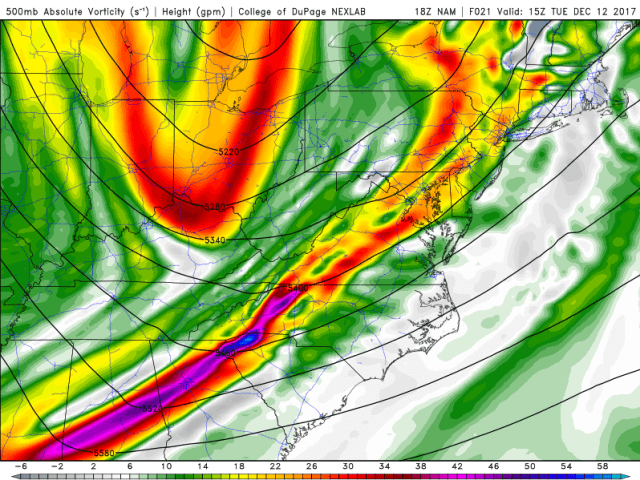
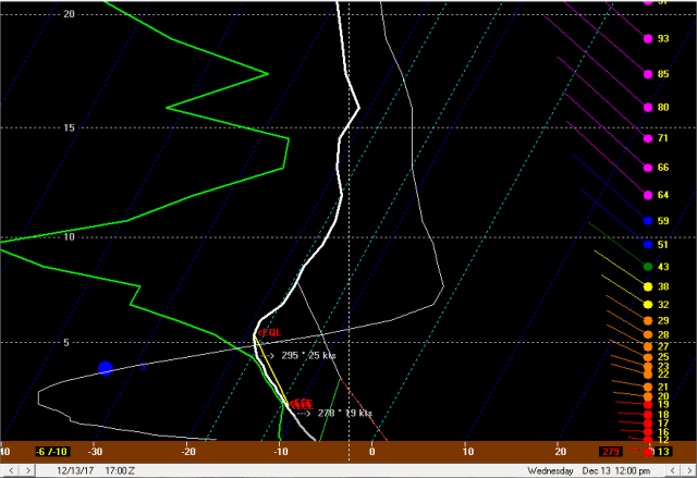
The passage of a weak shortwave and surface trough after midnight into the very early morning hours on Thursday is expected to bring winds around from the W to NNW over Lake Erie.  This should allow a brief burst of snow to push off the lake with EL heights of around 7k feet and steep lapse rates, good moisture, and some lift in the DGZ.  A brief period of subsidence behind this wave, rapidly shifting winds, and a brief period of dry air/low inversion heights suggest any lake effect late tonight behind the first shortwave will be minimal.  Think amounts will generally be 2” or less across the primary Snowbelt in NE OH/NW PA tonight and less than 1” in the Cleveland metro, with little farther south and west.

Another little wave/vort max will pass mid-morning through the early afternoon on Thursday, bringing improved moisture and higher inversion heights along with some modest large scale lift.  This, combined with a Lake Huron connection getting set up, should allow for a decent increase in snow Thursday morning and into the early afternoon.  850mb winds and RH from the GFS, NAM, and Euro all get the enhanced moisture from as far west as Cleveland east to near the OH/PA boarder in Ashtabula/western Erie County during this timeframe.  This suggests that much of the primary Snowbelt in NE OH and some surrounding areas like eastern Cuyahoga County and perhaps northern Summit/Portage and likely Trumbull Counties will get in on this lake effect snow Thursday morning and early afternoon.  EL heights rise to 7-8k feet with good moisture/lapse rates/lift in the DGZ, which is a moderate amount of instability and a suggestion of efficient snow.  There is some directional shear below the inversion so any bands may be disorganized/transient, but upslope enhanced snow will likely occur for a few hours mid-morning into the afternoon.  Rates of half an inch to an inch per hour will be broadly possible in the higher terrain, which may result in a 2-4” type accumulation in the favored areas through early afternoon in the higher terrain of the primary NE OH Snowbelt.  Thinking 1-3” in NW PA Thursday morning/early afternoon in the higher terrain.

Tough forecast in the secondary Snowbelt as the models show a wedge of dry air between upstream connections nosing into west and south of Cleveland.  The models are initializing with a frozen lake upstream of the secondary Snowbelt.  GOES16 imagery from this morning showed the gusty S-SW winds over the last day or so have pushed out and broken up a lot of that thin/newly formed ice, creating a lot of open water.  Although the lack of an upstream connection will hurt, favorable snow growth and likely a lot more moisture flux than the models show could result in an inch or two of snow in the higher terrain of the secondary Snowbelt as well.

Winds will slowly back a little bit (gain a more westerly component) Thursday afternoon, pushing the Huron fetch east of the east side of Cleveland and into more of NW PA.  May see another inch or locally two of snow in the higher terrain of the primary Snowbelt in NE OH/NW PA Thursday afternoon between the morning burst and later burst.  Another vort max will approach Thursday late afternoon and pass during the evening, resulting in another general increase in snow.  By evening 850mb temps will drop to -23 to -24C, pushing the DGZ below the cloud layer and limiting snow growth.  This will limit ratios and the efficiency of any snow accumulation.  The NAM and GFS both have super-saturation with respect to ice at the top of the DGZ Thursday night, suggesting some snow growth, but the NAM especially tends to over-do surface dew points in lake effect situations, and any error means little good snow growth.  Suspect ratios may hang up around 12-15:1 under any more coherent bands that could help push the DGZ a little higher through latent heat release, but that will still be down from earlier in the day (likely well over 20:1) and may not be realized in areas of lighter snow.  The Huron connection into Ashtabula County and NW PA will likely see the heaviest snow, though with snow growth beginning to suffer rates will likely struggle to exceed half an inch to inch per hour.  The rest of the higher terrain in the NE OH Snowbelt should also see an uptick, but again with an increasingly inefficient snow the rates will not be great.  Have similar questions about the lack of snow in the secondary Snowbelt given some open water upstream of that higher terrain, and think the higher terrain in southern Cuyahoga/northern Medina and surrounding areas sees another little uptick late Thursday afternoon into the evening.  With EL heights of near 8k feet at CLE and over 10k feet at ERI with instability becoming extreme and well-aligned winds, do think there could be some decent bursts of snow at times during the late afternoon and evening Thursday.  Given lowering ratios, suspect the evening uptick will result in 2-3” new by midnight in the higher terrain of NW PA where the Huron band effects, 1-2” in the higher terrain of the primary NE OH Snowbelt west of the Lake Huron enhancement, and perhaps up to 1” in the higher terrain of the secondary Snowbelt though likely less for most.

We lose some of the large scale lift the rest of Thursday night after late evening, but lake effect parameters don’t drop off much with extreme instability, OK but not great EL heights, decent moisture to 4-5k feet, and well-aligned winds.  Winds do back a little bit more overnight Thursday night shifting the upstream enhancement more firmly into NW PA, but some upslope enhancement should allow mainly light snow to continue overnight in the higher terrain in NE OH and at least some light snow showers in the higher terrain south of CLE as well.  Forecast soundings for CLE show considerably drier/colder low-levels than ERI, but given my belief there will be considerably more moisture flux east of the islands (and even some west) than modelled due to poor ice-cover initialization (and the fact that there is some moisture flux through ice, especially relatively new ice) I do not buy this.  The air upstream of CLE is not anymore cold/dry than the air upstream of ERI, and given my belief the models are under-doing moisture flux upstream of CLE the soundings there may end up looking a bit more like ERI than the forecasts for CLE do.  The models appear to have a faux convergence band into the eastern suburbs and Geauga County overnight due to a sharp temperature differential between ice/no ice north of Cleveland over the lake that I don’t think will be there.  There may be some shoreline convergence that enhances snow a little bit into the secondary Snowbelt and perhaps Cuyahoga/northern Summit/southern Geauga  given a flow around 290 to 300 degrees late Thursday night into Friday morning.  Given poor snow growth though and a relatively short fetch/no upstream connections in this area, don’t think any of this snow in NE OH will result in more than an additional inch to locally 2” in the higher terrain between midnight-7am Friday.  Better shot at around 2” or so in that timeframe in the higher terrain in NW PA where the moisture from Lake Huron allows for some better snow.

The day Friday will probably be pretty dull.  Expect general modest lake effect to continue with extreme instability and ok EL heights (pretty good at ERI) along with well-aligned winds, but with a dry airmass, short fetch, and poor snow growth only expecting 1 to locally 3” in the higher terrain in the NE OH primary Snowbelt, less than 1” in the secondary Snowbelt, and 2-3” in the higher terrain of NW PA where moisture from Lake Huron helps the cause some…maybe a local 4” in NW PA, but most likely less.

One last pretty decent shortwave passes Friday night, bringing some large scale lift, increasing moisture depth some, and raising inversion heights a bit.  Winds will also veer to a more NNW direction for a few hours behind it late Friday night.  Expect a general increase in snow in the primary and secondary NE OH Snowbelts and also in NW PA downwind of Lake Huron for a good few hours Friday evening into the early overnight hours.  Snow growth will still be poor, though if a stronger band develops it and ratios may locally improve.  Extreme instability, EL heights rising to over 10k feet at CLE and ERI, and moisture depth increasing to 5-6k feet along with some lift from the shortwave should allow moderate snow to occur in the higher terrain, perhaps locally heavy downwind of Lake Huron.  Some shoreline convergence may also direct a bit of a band into the secondary Snowbelt, on top of the Lake Huron enhancement into NW PA and general orographic lift snow elsewhere.   The Huron band may briefly swing into Ashtabula County early Saturday morning, before everything shifts NE and inversion heights really lower on Saturday, finally winding down the snow during the afternoon.  With poor snow growth not expecting more than 2-3” in the higher terrain of NE OH/NW PA Friday night into early Saturday from the uptick from the shortwave, expect for perhaps locally 4” or so if a good Huron enhanced band can develop over Ashtabula County or into NW PA.

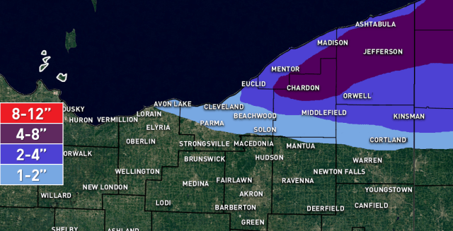
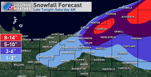
Adding up the period to period snowfall amounts does yield amounts potentially exceeding a foot in the heart of the NE Ohio Snowbelt and inland NW PA, with local amounts of up to 15 or 16” not impossible in NW PA.  Amounts will be considerably less near the lakeshore.  Given decent enhancement expected into eastern Cuyahoga County Thursday morning and enough terrain for orographic lift there through the rest of the event, think amounts of over half a foot will occur into eastern Cuyahoga.  Similar story in some of the northern extremities of counties south of the Snowbelt.  Will put 1-3” in for the secondary Snowbelt, though it’ll be apparent early on if there will be enough moisture flux for higher amounts there.  If so, could see how it eventually adds up to around half a foot through Friday night in parts of northern Medina County.

Posted in Uncategorized | Leave a comment

Quick Thoughts on New Year’s Lake Effect Snow

snow 1-1

Just some quick thoughts before I head out for the night…

Winds will be WNW, however, am concerned the ice near the southern shore and also over the western basin extending into the central basin may allow the shoreline convergence to occur a little farther north closer to the remaining open water. Ice coverage over the western basin is now over 90% with a thickness of 6-12″+, which is thick enough to be more prohibitive of good heat/moisture flux. So, will cut off the snow farther northeast than I would for this type of flow with an open lake. Still, with some moisture flux and a good fetch from Lake Michigan aimed towards the Cleveland area, was nervous enough to include an inch or two for the Cleveland metro and expand the 2-4″ a bit farther SW than the hi-res models suggest.

With a well-aligned WNW flow from early Monday AM through the evening before the winds start backing and pushing the snow up the shoreline, will be a 12 or so hour window of good snow. Parameters are OK with EL heights near 8k feet and moderate instability. The airmass is quite dry but Lake Michigan pre-conditioning and reasonably light/well-aligned winds will make up for that a bit. The NAM shows super-saturation with respect to ice in the upper half of the very shallow dendritic growth zone and upward motion in the DGZ, so if the NAM doesn’t bust too high with its dew points there should still be enough snow growth for decent ratios, though the airmass is quite cold and it’s close, if dew points are lower than the NAM ratios may struggle outside of any stronger bnd. Given OK instability and a good WNW fetch without a ton of movement for around 12 hours, will go with 4-8″ in the northern primary Snowbelt. There may be a convergence band possibly from NE Cuyahoga into southern Lake/northern Geauga/Ashtabula caused by the interface between mostly ice-covered and thicker ice and open water pushing the convergence a bit north of the shoreline. Where any more dominant bands develop over NE OH/NW PA will be where the best shot at closer to 8″ will be. Think there will be a band that develops over the northern Snowbelt from Lake/Ashtabula/Erie Counties early Monday ahead of a vort max that then swings SW as winds go WNW by later morning. The band will likely lift NE Monday night then push over the lake by Tuesday. Could see a locally higher amount in Erie County as they’ll have a longer window for snow through Monday night than NE OH.

Happy New Year!

Posted in Uncategorized | Leave a comment

12/29/17: Meteorological Discussion on Upcoming Clipper/Lake Effect Snow

12-29 no logo

Unfortunately, another snow event where I don’t have time to do more than a text-only write-up…pretty interesting forecast yet again…

Snow should push onshore into northeastern Ashtabula and Erie County near the lakeshore by around noon Friday as winds on the lake come around to west with WSW winds on land behind the passage of a vort max and surface trough/possible meso-low over the lake.  This general wind pattern with W winds over the lake and WSW winds on land focusing convergence near the coast in Erie, Ashtabula, and possibly NE Lake Counties will persist all of Friday afternoon and into the early evening before winds shift more SWrly and push the convergence out over the lake.  This will still be a good 7 or 8 hours of potential banding near the lakeshore in eastern Ashtabula and Erie Counties (possibly brushing NE Lake and western Ashtabula County) Friday afternoon into the evening.  Thermodynamics during the afternoon will be decently supportive with moderate instability, EL heights of 10-11k feet, and good moisture to around 7k feet including in the DGZ.  EL heights drop off some towards evening due to mid-level warm air advection ahead of the incoming clipper.  With the decent thermodynamics/moisture, strong convergence near the shore, weak shear in the mixed layer, and near-optimal snow growth have to think snow rates of around 2″ per hour will accompany the heart of the snow band Friday afternoon and early evening.  The band will mainly hug the shore and not move a ton, and may produce 6-12″ of snow near the lake in Erie County and also northeast Asthabula County, dropping off quickly farther inland.  There may be an inch or two as far southwest as northeastern Lake County.

The clipper snow doesn’t look extremely impressive in N OH Friday evening and Friday night.  There will be some lift in the form of upper-level divergence evident at 500mb (which is above the level of non-divergence in winter), some mid-level positive vorticity advection, and weak isentropic lift/warm-air advection evident at times at 700mb and 850mb.  This will generally cause a decently long period where light snow will be possible.  Forecast soundings currently suggest that the strongest lift may be above the DGZ during the synoptic snow keeping ratios somewhat in check, and the sources for lift aren’t extremely strong, so I tend to think amounts with the clipper in northern OH/NW PA will only be 1-2″.  There may be pixie dust or small flakes falling for a while which will be nice, but they won’t add up a ton.

Winds will come back around to the W or WNW over the lake by Saturday morning which will bring lake effect back into the picture.  Lingering synoptic moisture to over 10k feet through most of the morning and outstanding thermodynamics with EL heights of 10-12k feet (higher at ERI) and steep lapse rates to go along with convergence near the shoreline will support an intense lake effect snow band.  In addition, a potent vort max will pass overhead late morning and early afternoon, adding some large-scale lift.  Given nearly optimal snow growth, rates of 2 to locally 4” per hour will be possible in the heart of the band.  Band placement will be important, as some areas may see a lot of snow quickly in the Saturday morning/early afternoon timeframe.  To start the day, winds will be W over the lake and WSW on land…a familiar pattern…which will likely drive the band onshore over northeastern Ashtabula County and the Erie County lakeshore.  It may be snowing in parts of Lake County but likely won’t be that heavy at this juncture.  Winds will continue to slowly gain a more northerly component and by mid-morning are expected to be WNW over the lake and slightly south of due west of land.  With an approaching vort max (which seems to tend to keep winds more “backed” or southerly around the lake) and shoreline convergence, don’t think the band will push inland too fast, but may get into far NE Cuyahoga and northern Geauga by mid-morning, with heavier snow spreading into Lake County and the rest of northern Asthabula County.  Snow may start spreading a bit farther inland over Erie County by mid-morning.  The vort max passes around noon which should nudge the surface trough farther south as the winds likely gain more of a northerly component behind the vort max.  This should allow the band to gradually resume a more southward drift during the early afternoon.

I don’t expect the band to get too far south, as the vort max really only grazes the region with no big height falls with it, so there shouldn’t be a huge push of northerly winds Saturday afternoon…but likely enough to get the band into a good chunk of Cuyahoga County (possibly into the central part of the county) and more inland portions of the Snowbelt.  The thermodynamic environment will remain very favorable and with good snow growth to go along with some pre-seeding from Lake Michigan, though the shoreline induced convergence will likely weaken some and there will be a brief period of sinking motion during the early to mid-afternoon behind the vort max.  This should cause the band to become less organized and weaken a bit, though it probably won’t completely go away.  Ice cover over the western basin is over 80% which will limit moisture flux some, however, the ice is still not that thick and still has some cracks, which typically still allows a half decent moisture flux.  Given the strong instability and high EL heights, I think that while the ice will somewhat limit the band intensity over Lorain and Cuyahoga Counties where the fetch of open water is much diminished that it won’t completely prohibit some decently intense snow.

Another potent vort max and surface trough (with much colder air behind it) approaches late afternoon and early evening and passes around mid-evening Saturday.  These features tend to back surface winds a bit more than modelled, which suggests winds may be around 280 degrees as this vort max and trough approach.  The lift and moisture ahead of the vort max and likely upstream moisture from Lake Michigan, along with increasing convergence near the shoreline should allow a decent band to re-develop.  This band will likely develop across northern Lorain County and northern/central Cuyahoga County east into southern Lake County and Geauga County and swing south by mid-evening behind the vort max as winds then quickly go more NNW.  Though there may not be an organized convergence band over NW PA, Lake Huron moisture and increased lift should still result in a nice burst of snow.  Instability will be extreme by this point with ample moisture/good snow growth remaining in place, so the band could produce a quick few inches over parts of the Cleveland metro and into the Snowbelt, likely a bit inland form the lake, as well as in parts of NW PA especially in the higher terrain.  A brief period of good moisture behind the winds turning to the NNW may briefly allow upslope snow to continue through late evening, though colder air will start hurting snow growth.  Given the stronger vort max/surface trough passage and cold push of air, the snow band could detatch from the lake and push inland as a strong snow squall that drops a quick 1-2” of snow.  Lake Michigan moisture may contribute to a risk of squalls well west of the NE Ohio Snowbelt as well Saturday evening as the trough moves through.

Behind the trough the thermodynamics remain impressive with EL heights over 10-11k feet and extreme instability over the lake, but the airmass dries considerably for the remainder of Saturday night and through Sunday night.  This will likely limit snow outside of a Lake Huron connection.  With well-aligned winds, extreme instability, and this connection going over the open part of our lake, it may produce heavy snow.  NAM soundings show the DGZ remaining in the clouds in the Huron connection through Sunday supporting high ratios.  Models tend to bring these connections too far west, but with a NNW flow think it should get into at least Asthabula County for a decent period of time Saturday night through much of Sunday and may briefly drift into Geauga/Lake Counties late Saturday night when winds have their strongest northerly component.  Winds back Sunday night which should push the connection east.  Given the winds don’t move a ton, are well aligned, and instability is extreme, this Huron connection may drop a general 3-6” over far eastern Lake/Geauga, Asthabula, and western Erie/Crawford Counties, with locally much higher amounts possible if the band stalls for any decent length of time.  With extreme instability and wind fields getting a bit light late Saturday night into Sunday, meso-low formation may be possible with the band which could move it around at times and also bring locally enhanced snow rates.  Outside of the Huron connection, a short fetch, limited moisture hurting snow growth, but extreme instability and fairly light/well-aligned winds may allow modest snow showers to continue in the higher terrain as far west as the secondary Snowbelt.  This may add a local inch or two after midnight Saturday night through Sunday in the higher terrain west of the Lake Huron connection.

For total amounts, think there’s ample opportunity for snow for 12”+ along the lakeshore in northeast Ashtabula County and Erie County, PA.  Given a couple shots at banding, local amounts of 18-24” seem doable in Erie County within 10 miles of the lake.  Elsewhere, expect the rest of the core Snowbelt (parts of the eastern suburbs, inland Lake, northern Geauga, inland Ashtabula, inland Erie and northern Crawford) to see a general 6-12” of snow given banding likely getting in off and on Saturday mid-morning through evening, with some light upslope enhanced snow then continuing through Sunday.  Wherever the Huron band sets up, the potential for over a foot will exist.  Farther west/south, given 1-2” of clipper snow, potential squalls enhanced by moisture from Lake Michigan and the vort maxes, and likely a squall pushing south off of Lake Erie Saturday evening, think most areas can see over 4”…so will go 4-7” for much of the Cleveland and Akron metro down to Youngstown.  Given how unstable the airmass is before adding in the lakes, good snow ratios, sources of synoptic lift, and then moisture from the lakes, I have to think it’ll be a snowy Saturday and Saturday evening at times in these areas.  The moisture from Lake Michigan may also get wrung out in the central highlands at times adding some modest additional accums there on top of 1-3” of clipper snow.

Posted in Uncategorized | Leave a comment

High Resolution Satellite Imagery Captures Meteorological Features

goes 16 loop

The GOES16 weather satellite is back in action and provides a very detailed look at some cool meteorological features…let’s dive in to what we can see:

1) LAKE EFFECT! Every large lake in the image (even Lake St. Clair) is producing lake effect clouds and snow. Note how cloud cover increases as air moves across the lakes, gradually picking up moisture and heat as it goes. There are several intricacies to lake effect evident here:
a) shoreline convergence and divergence. Note how when clouds hit the western and northern shores of Lake Erie, they actually tend to weaken as they initially hit the water. This is due to winds over water being faster than on land. This causes “diverging” winds in the lower levels, which actually causes downward motion as air first hits the lake. Note how clouds are typically puffier just downwind of the lake, due to the opposite effect; faster-moving air over the lake runs into slower moving air on land, causing the air to literally pile up and resulting in upward motion.
b) heat and moisture are still transported through ice! essentially all of western Lake Erie is frozen, but lake effect clouds are clearly bubbling up over the ice. Thin ice in particular still transports a good amount of heat and moisture through to the air, which is why lake effect can occur off of a rather icy lake.
c) other sources of moisture greatly aid our lake effect. Note how at the end of the loop, more robust clouds from over Michigan hit the western basin of Lake Erie, causing the lake effect clouds to expand and become puffier looking (taller).
d) converging winds cause more organized bands; note the band of more puffy looking clouds coming onshore east of Cleveland, with the clouds north and south of the band clearly converging on the band. Convergence, either down the middle of the lake or due to an interaction with the shoreline, is one of the main causes for intense bands of lake effect that produce the most prolific snowfall. Winds often converge near the shoreline due to friction causing slower and more southerly (or backed) winds on land and colder air over land causing the air to be denser inland from the lake.

2) WINDEX or Wintertime INstability inDEX: WINDEX snow showers occur as a result of a very cold air mass moving over warmer ground, causing the low-levels of the atmosphere to become unstable. Note the rows of clouds that develop during the day across a lot of areas well away from any lake effect; these are the result of WINDEX! What’s cool is that areas that have a deeper snow cover (such as a swath of NW Ohio) and hence have less heat transferred from the ground see no cloud development, while areas of less snow cover (such as near Detroit and much of inland NE Ohio) see cloud development. There’s even cloud development over Toledo as the result of an urban heat island creating locally warmer ground-level temperatures! This phenominon is often why snow showers and squalls often develop even well away from the Great Lakes the day after a strong cold front moves through during the fall or early winter. In this case, since much of the area has some snow cover and because the airmass is very dry, only flurries fell out of these clouds.

3) A source of large-scale lift acting on low-level cloud development. A “vorticity maximum” is moving across southern Michigan this afternoon, with lift ahead of the feature. Note how the WINDEX and lake effect clouds gradually get puffier looking or taller from west to east during the second half of the loop, hitting Lake Erie just as the sun starts going down. This is why subtle features that cause even weak large scale lift are important to lake effect snow forecasting.

Posted in Uncategorized | Leave a comment

12/26/17: Update on Additional Lake Effect Snow in Northeastern Ohio

snow 12-26

This is a pretty interesting/tough forecast for the remainder of this LES event through Wednesday night…

Indications are the band (which the heart of is actually north of Erie at the moment) will reach its farther north point by 7-8pm, and then begin sinking back south as a weak surface trough evident over SE MI pushes east this evening and causes winds over the lake to shift from SW to more west. This should allow convergence to increase from near Euclid up the shoreline and allow decent snow to develop up the shoreline in NE Ohio by mid to late evening. As winds on the lake continue to gradually veer to more WNW after midnight, the snow will likely push inland into more of NE Cuyahoga and northern Geauga County. Given WNW to almost NW winds over the lake I have to imagine it will push inland over Erie County as well.

The band will likely stall or really slow down for several hours after midnight or 1am, especially across the eastern Cleveland metro. This is due to the winds on the lake not moving much, possibly in response to the mid-level shortwave approaching/moving overhead, and due to the shape of the shoreline near Cleveland likely focusing shoreline convergence in that area for several hours. The hi-res models have a known bias (that has been on display constantly this event) to underdo shoreline convergence and push bands inland too quickly. Given where the models place the band, the expected wind direction, and shape of the shoreline, my guess is it will lay near the western lakeshore (perhaps nipping land at times very close to the lake west of Cleveland) and then move inland near or just slightly NE of downtown and then push ESE through the eastern suburbs towards Chesterland and South Russel. The NAM and RAP both have a crosshair signature for several hours late tonight (strong lift in the DGZ and decent RH in the upper half or so of the DGZ), which along with moderate lake-induced instability and EL heights of 9-10k feet suggests the band will produce heavy snow with rates of 1-2″ per hour. Given it may move little for several hours, the potential for several inches of snow exists in the eastern suburbs into northwestern or west-central Geauga County. With some large scale lift from the shortwave passage think the higher terrain in the rest of the northern Snowbelt will hang on to snow showers in this time, but nothing too organized or heavy. If this band pans out could see some spots get near 8″ by morning under the band in the eastern suburbs.

The shortwave finally passes Wednesday morning, resulting in some sinking motion and winds veering even more to NW over the lake. As temps on land warm the lake-aggregate trough and shoreline convergence should weaken, causing the band to swing southwest and become less organized. The band will likely lose its lake Michigan connection Wednesday afternoon. Even so, moderate to borderline extreme instability may result in snow showers continuing from Lorain County points east, likely heaviest a bit inland given no dominant band or shoreline convergence. These may result in additional light accumulations late Wednesday morning through the afternoon. The combination of a cold and somewhat drier airmass may limit snow growth late Wednesday morning and beyond, possibly limiting ratios with any snow showers that persist, so I suspect amounts after about 10am Wednesday through the rest of the day will be reasonably under control.

I still don’t trust Wednesday night not to produce some additional accumulations. With winds going NW to even NNW a Lake Huron band may set up over NW PA and produce a couple inches or so. As temps drop on land convergence will increase along the rest of the shoreline. With winds going very light after midnight, some “tea kettle” snow may result with convergence near the shore just spilling inland, possibly dropping accumulating snow near the shore. This could occur as far west as Lorain County. The light winds and extreme temp differential between land and water may support meso-low formation too, which could also brush the shore with some accumulating snow. Any lingering snow should end Thursday morning.

For additional accums, given the band gradually progressing south tonight think a general 4″+ is doable over most of the northern Snowbelt. I kept amounts at 4-8″ over the eastern suburbs into western Geauga County, though I can’t rule out a higher amount if the band after midnight into early Wednesday remains stationary enough. A few mile bust in band location results in a lot of population seeing different amounts, so that’s a sensitive forecast which also factored into my decision not to pin down a 6-12″ area. Think the period of snow along the shore tonight along with the potential for tea kettle lake effect Wednesday night supports 4″+ additional snow even along the coast. With the band currently affecting extreme NE Ashtabula County and coastal Erie County, along with a potential for a Huron connection early tomorrow night and tea kettle snow after midnight that 6-12″ (locally more) is doable in those areas. The inland penetration of snow in NW PA is tough, but think once the band swings south later tonight with a quick accumulation that enough opportunities for snow showers (especially if some Huron moisture is involved) exists for at least a few to several inches of total additional accumulation in inland Erie County possibly clipping northern Crawford County.

Posted in Uncategorized | Leave a comment

12/25/17: Quick Write-Up on Upcoming Lake Effect Snow

snow 12-25

Here’s my first guess on the LES…I’m trying to sneak in a nap before the Cavs play so this write-up will be a little more curt than normal with no images.

Winds will turn around to a more due westerly direction over the lake this evening behind a weak mid-level shortwave, which should allow convergence to move back south to northeastern Lake County and northern Ashtabula County and re-intensify over northern Erie County as we head into tonight. This is expected to allow the lake effect snow band to push back onto land near the lake in this area. Convergence will be strong near the shoreline with moderate lake-induced instability to go along with ample moisture below about 6-7k feet and EL heights of 8-10k feet (lower at CLE higher at ERI). BUFKIT shows lift focused in the DGZ along with high RH through most of the DGZ promoting high ratios, which along with the convergence and decent but not outstanding instability should allow for 1-2″ per hour snow rates thanks to the ratios in the band. Some pre-seeding from Lake Michigan is also expected to develop tonight, which along with weakening winds maximizing residence time and a long fetch should allow the band to take full advantage of the fairly good parameters in place. The band may move little from this evening into the overnight, and may produce 6-10″ of snow in a few or several hour period of time where it affects. The most likely area to see this will be extreme eastern Lake County, northern Ashtabula County, and the northern half or so of Erie County, PA.

All models show the winds coming around to a solid WNW direction over the lake late tonight through Tuesday morning, which should push the convergence and band a little farther south. Winds inland will remain WSW, and a strong temperature difference between over water and inland should result in a strong lake-aggregate trough, which along with the WNW winds not being terribly strong argue against the band pushing very far inland. The hi-res models do try to push the band as far south as Downtown and NE Cuyahoga/central Geagua/southern Ashtabula County. Given the aforementioned factors and known bias for models to place LES bands a little too far south, my guess is we’ll see the band get to extreme NE Cuyahoga County (Euclid/Mayfield area) but not quite to Downtown and then points east into Lake County and Geauga County mainly near and north of route 6. It may briefly get as far south as close to 322, but I’d hedge on heavier amounts being closer to 6. With a solid WNW push of winds, the band will probably push south of the Ashtabula County and Erie County lakeshore for several hours late tonight into Tuesday morning. Parameters remain similar to those described above, which should allow rates of 1-2″ per hour to continue under the heart of the band. Winds may move slowly enough for a the band to be relatively stationary for a few hours, possibly allowing another 4-8″ of snow to fall under the band late tonight through noon Tuesday. The area most likely to see this will be Lake County, northern Geauga County, Ashtabula County just inland from the lake, and perhaps far northeast Cuyahoga County.

Tuesday afternoon the winds will back to the west/southwest over the lake ahead of a more robust shortwave, likely causing snow to lift north and potentially reorganize for a few hours over northeastern Ashtabula County into Erie County, possibly dropping another corridor of several inches of snow fairly quickly. Behind that wave Tuesday evening through Wednesday the winds will gradually veer and instability/moisture depth will improve. Winds inland will remain WSW and a strong temperature differential will remain between the lake and land, likely maintaining strong convergence near the shore. This will push the band back down the shore and gradually a bit farther inland Tuesday night into Wednesday. It may affect the northern Snowbelt (extreme NE Cuyahoga, Lake, northern Geauga, northern/central Ashtabula, parts of Erie County likely a bit inland) for a few hours later Tuesday evening as the winds on some models get hung up a bit ahead of another little 700mb vort max. EL heights of near or better than 10k feet (higher on the ERI soundings) and good moisture to 7k feet, a long fetch with relatively weak winds/little shear on soundings over the lake, moisture from Lake Michigan, along with a saturated DGZ and strong lift centered in the DGZ in the band on both the GFS and NAM suggest the band could produce very efficient and heavy snow, with rates of 2 to perhaps 4″ per hour likely Tuesday evening. If it slows/stalls for a few hours over the northern Snowbelt, that corridor would see an additional 6″+ quickly and possibly up to a foot in short order.

The band should resume its southward drift around midnight or so behind the vort max and should get into much more of Cuyahoga County. This will be an interesting setup for Cuyahoga County late Tuesday night through a good chunk of Wednesday. Models show winds of 285-295 degress with a clear trough axis near the county, with CLE BUFKIT soundings maintaining extreme instability, EL heights of near 10k feet, moisture in the lowest 5k feet at least (higher through mid-morning Wednesday), and lift centered in the DGZ. A Lake Michigan connection should maintain through most of Wednesday and winds will be fairly light/well aligned, maximizing residence time and it won’t be a short fetch. There is enough juice for a warning criteria snowfall over much of northern/eastern Cuyahoga County including in or near Cleveland into central/southern Geauga County late Tuesday night and through Wednesday, with more disorganized snow showers focused mainly in the higher terrain in the rest of the Snowbelt during the day as the convergence should be well south by that point. This band could also affect far northeastern Lorain County at times. Still some time to evaluate the potential in Cuyahoga County, but a number of ingredients still appear to be in place. One potential negative will be temps getting cold enough Wednesday afternoon and low-level dew points dropping enough to start drying out the DGZ. This could cause snow ratios to diminish Wednesday afternoon, though right now indications are ratios should remain pretty high through Wednesday morning, especially in any organized bands where latent heat release would likely push the DGZ up into the clouds.

The lake effect will really diminish Wednesday night, however, some additional accumulations aren’t impossible. EL heights will remain 5-7k feet with some moisture beneath the inversion and steep lapse rates. Winds will be very light and veer onshore. The light winds and strong low-level instability may favor meso-low development or at least some “tea kettle” lake effect that grazes the shore. This could produce locally another couple inches or so Wednesday night mainly near the lake.

For total accumulations, think there’s more than enough opportunity for heavy snow to go with 1-2′ in the northern Primary Snowbelt. The bands will be moving off and on which may limit the max potential in OH (and even in PA for additional snow starting this evening) to around 2 feet. Kept the southern cutoff a bit north of what many models have, however, if factors continue to point to a decent period of LES in Cuyahoga/southern Geauga Counties later Tuesday night into Wednesday night amounts will need to be bumped up in those areas. I fully think LES warnings will be needed for Lake and Geauga Counties. Cuyahoga County will eventually need at least an advisory, with potential for localized warning amounts late tonight into Tuesday morning in the extreme NE corner of the county as well as for more widespread warning amounts Tuesday through Wednesday evening.

Posted in Uncategorized | Leave a comment

12/11/17: Moderate to Heavy Snow Coming to Parts of Northeast Ohio

12-12 NEO

12-12 state

Lake effect snow is on the way for Northeastern Ohio!  Some dry air and a short fetch may limit the snow outside of some narrow bands, but a lot of areas will see a few to several inches of snow…with locally a foot possible in the higher terrain if bands can persist.  Here is the meteorological discussion:

current wv

Current water vapor imagery shows a potent vort max over IL that will move roughly east tonight, causing a low pressure to deepen as it tracks over northern OH late tonight.  On the backside of the low later tonight low-level convergence, deformation between the vort max and anther shortwave currently near Lake Superior dropping SSE, and lake enhancement processes will result in several hours of snow over north-central and northeast Ohio.

NAM 15 500

The deformation can be seen very nicely on the 500mb wind plots on the models, and the heart of it moves right over northern Ohio and Lake Erie between 6z and 12z tonight-Tuesday morning.  This will drive light to perhaps briefly moderate synoptic snow across the lake and northern Ohio later tonight into early Tuesday.

NAM 15 conv

As the low passes to our east, winds will flip around to the NW after 3-4am Tuesday.  There will be some increase in convergence with the wind shift, and also an increase in shoreline convergence downwind of Lake Erie and upslope in the higher terrain.  This may result in a brief burst of better moderate snow with the wind shift itself followed by moderate snow continuing just downwind of the lake in the higher terrain due to convergence along the shoreline and upslope.  Due to temps near freezing the snow will be on the wetter/low ratio side initially, though ratios will quickly go up Tuesday morning as colder air pours in.

BUFKIT 1

The deformation zone begins pulling away to the east by around 12z/7am Tuesday, which will cause the organized light to moderate synoptic snow to diminish from west to east to start the day Tuesday.  While this occurs, instability will really improve downwind of the lake, which along with any lingering synoptic moisture should keep decent snow going mainly in the higher terrain.  The snow will likely be rather disorganized due to some shear and a short fetch across the lake, but should keep going.  A lowering DGZ should result in ratios beginning to improve as well.

NAM 21 500.png

Although the deformation and organized synoptic snow should start pulling away around 12z Tuesday, a potent shortwave will cross.  PVA/lift ahead of the shortwave, along with favorable moisture and instability profiles below 10k feet, should keep snow showers going downwind of the lake, particularly in the higher terrain.  700mb RH remains high until the crossing of this shortwave, and I think that moisture and lift will be enough to keep decent snows going in orographic lift ahead of this shortwave.  With steepening low-level lapse rates, some briefly squally snow showers could also occur outside of any lake effect with this feature.

BUFKIT 2

After the shortwave passage late morning, moisture strips away both at the surface and aloft, which along with the brief period of sinking motion behind the shortwave should result in the snow being disrupted for a few hours.  By later in the afternoon the winds become very well aligned out of the NW and instability becomes extreme, with equilibrium levels of near 11-12k feet and good moisture to about 7k feet.  This should result in lake effect improving, however, the fetch is on the shorter side amd wind speeds in the mixed layer are greater than 30 knots, making it questionable how widespread the lake effect will initially be.

NAM 27 925

With some drier air and a shorter fetch/stronger winds, upstream connections may be critical to where moderate to heavy bands can develop Tuesday afternoon/evening.  There will be a few corridors to watch:

  • Off of southern Lake Michigan into western OH…won’t do anything for Lake Erie, but will bring swaths of light accumulation to parts of western OH.
  • From near Traverse City to southwestern Lake Erie. This connection could be interesting, as the wind direction of around 300 degrees will favor convergence near the southern shore in the western basin…this connection and local convergence could allow a half decent band to form for a time from Huron County into southern Lorain County and parts of Medina/Summit Counties.
  • A potential minor connection with western Lake Huron/Lake St. Clair into the higher terrain of the primary Snowbelt.
  • A likely connection from Lake Huron into NW PA.

Outside of any connections there will probably be some sizeable breaks in the snow late Tuesday afternoon and evening.  There may be one last shot of synoptic moisture/lift Tuesday night, which could potentially result in a significant uptick in snow, but this may stay just east of most of NE Ohio.

NAM 33 700

The models all show a vort max dropping south on the west side of the larger low to our east Tuesday night.  The NAM (above) shows the better lift and moisture just grazing NE Ohio, likely resulting in some increase in activity, especially from Geauga County points east and definitely in NW PA, but probably keeping the heavier activity limited to a few bands.

GFS 33 700

The GFS is a good 50-75 miles farther SW with the vort max and increased synoptic moisture/lift, and would likely result in a significant increase in activity in the Cleveland metro and secondary Snowbelt as well.  The Euro is closer to the GFS, but perhaps not as extreme with how much RH it shows at 700mb.  Regardless of the vort max, some PVA with the back wall of the trough later Wednesday night may also result in some increase in activity.

BUFKIT 3

The thermodynamic profile is quite good Tuesday night for lake effect snow, with equilibrium levels remaining above 10k feet to go along with lake to 850mb and lake to 700mb temp differentials of near 25C and 32-34C respectively, giving extreme instability.  Winds also become well-aligned, and the wind speeds in the mixed layer decrease a bit (but still remain stronger than preferable given the shorter fetch).  If we see a NAM-like scenario play out with the better synoptic moisture/lift not hitting NE Ohio well, we’ll likely see a few organized and intense bands play out, but with significant breaks between the bands.  NW PA looks to do really well either way, especially where the Lake Huron connection comes in.  If we see better synoptic moisture/lift into NE Ohio, then a more general moderate to heavy snow may break out for a few hours in the higher terrain, with any bands intensifying.  Either way, the synoptic support diminishes later Tuesday night and moisture aloft does start stripping away, so we’ll likely go back to a more localized multi-banded setup later Tuesday night even if we do see a more significant uptick in the evening.

BUFKIT 4

Wednesday morning should feature just a few remnant multi-bands as we lose the synoptic support, moisture strips away above 5k feet, and inversion heights fall.  There may be enough juice for a transient west to east band to flare-up later Wednesday morning and afternoon from Cuyahoga County points east/northeast as the winds back.  With moisture below 5k feet and lift/steep lapse rates through the DGZ, along with a better fetch, this band could produce some additional accumulations.  Seeding from mid-level moisture will also help potentially produce some accumulating snow with this band Wednesday afternoon.  Winds will be backing pretty quickly and will be SW by late afternoon, likely pushing the band over the lake by late afternoon/early evening and keeping it from dumping on any one area before then, but this could lead to one last gasp of accumulations for some areas in the primary Snowbelt.

AS FOR AMOUNTS…

The synoptic snow should produce a general 1-3” for much of north-central and northeastern Ohio, even outside of any lake effect areas and along the lakeshore.  In the higher terrain of the secondary and especially primary Snowbelt where lake enhancement/orographic lift will augment the synoptic snow, there could be a good period from about 2am to 10 or 11am of decent snows with improving ratios after sunrise.  This could result in a general 3-6” in the higher terrain by noon Tuesday in NE OH/NW PA (secondary Snowbelt will see the lower end of that).

As lake effect gets better organized Tuesday afternoon, will likely see corridors of 1 to locally 3” of additional snow through the afternoon from potentially Huron/southern Lorain and parts of Medina/Summit Counties points northeast.  I think the best chance for 3” will be in the higher terrain of NW PA, most should see less during the afternoon…I just think the bands will be too localized for widespread heavier amounts during just the afternoon.

During the night we’ll likely see at least a few bands with heavy snow persist most of the night.  The area closest to a slam dunk for heavy accumulations overnight will be the higher terrain of NW PA due to a very high likelihood of synoptic enhancement to the snow and a Lake Huron connection, along with a longer fetch over Lake Erie and more terrain to wring out the moisture.  In NE Ohio I think given the tremendous instability and well-aligned winds that two or three more intense bands will setup and may drop up to a few inches, even if we don’t get the better synoptic moisture and lift.  If we don’t see the synoptic assist, totals in NE Ohio will likely vary from 1 to locally 4” additional overnight…locally could see more, but it would be very localized and is hard to pin down ahead of time.  If there’s better synoptic support over NE Ohio as well, which the GFS and Euro do currently show, then a widespread 2-4” in the higher terrain with amounts of potentially over 6” in better bands would be on the table.  For now my forecast will be a compromise solution with a general 2 to locally 5” overnight in the higher terrain of the NE Ohio Snowbelt, including potentially a band well SW of Cleveland as discussed above, with less than 2” along the shore.  Will go for a general 3-7” in the higher terrain of inland Erie County and northern Crawford County PA overnight Tuesday night, but a locally higher amount is quite possible if a more dominant Lake Huron connection sets up for a length of time.

On Wednesday have to think any band would be transient enough that additional amounts will struggle to exceed 1-3” anywhere.  Will anticipate light additional amounts from the potential band in northern and eastern Cuyahoga County, Lake County, Geauga County, Ashtabula County, and perhaps Erie County PA.

For storm totals…highest will be in NW PA, where I’m coming up with around 9-19” (will go with 12-18”).  In the higher terrain in northern Geauga and inland Ashtabula County, I’m coming up with around 7-17 (will go with 8-14”).  The higher terrain south of CLE in the secondary Snowbelt I’m coming up with 5-12”…I highly doubt the 12”, as the higher ends of each period after the synoptic snow are due to a potential localized heavier band, so I’ll call that area 4-8”.  The NAM has that SWern band setting up from central Medina County into northern Wayne County towards Stark County for quite a while…think that is a little too far SW, but it’s not unheard of for a band in this type of flow to work it’s way down towards CAK in southern Summit County, so I will show somewhat heavier amounts in that area to account for the possibility.  Will show just 1-3”/2-5” amounts along the shore in Lorain/Cuyahoga/Lake Counties, but bump up some farther NE where there’ll be better synoptic support during the lake effect.  Will show amounts increasing in the higher terrain in southern and eastern Cuyahoga County due to better orographic lift.  Could see a 10” amount in extreme east-central Cuyahoga County if banding can set up over that area for any length of time at some point.


Posted in Uncategorized | Leave a comment

Thanksgiving Long Range: Warm Start to December, Cold to Follow


mtd temps

Month to date temperatures departures for November through 11/22/17


A generally cold week in the eastern US has eaten away at the warm departures over the Southeast on this map a week ago, and now overall the continental United States (CONUS) is running a -0.6 degree departure for the month of November…this isn’t an earth-shattering value, but the last November that saw a negative temperature departure overall in the CONUS was 2014, so this is a shift from the last couple of falls.


current 500

Observed upper-level (500mb) weather pattern over the last week across the Northern Hemisphere


The story of the last week has been a favorable Atlantic (-NAO) and unfavorable Pacific doing battle over the central and eastern US.  The result has been a mild trough and predominantly colder than normal conditions over the east and a mild ridge and warmer conditions in the west, but due to the conflicting signals neither area was able to really lock in.  With a –PNA (ridging over the Aleutians and a trough just off the West Coast) and +EPO (troughing over Alaska), had the –NAO not been there it likely would’ve been a pretty mild week in the central and eastern US.  So, the –NAO had an impact, despite what you may read elsewhere, but the northeast saw very little snow and that was mainly in lake effect areas and upslope areas in northern New England.  This is a good example of how a –NAO can fail to produce a winter storm over the eastern US (which happens quite often), but also of how a –NAO can try to overcome a poor pattern elsewhere.  It’s all connected and you can’t just look at one index and hope to make a successful forecast.  Had the Pacific been better, the trough over the eastern US likely would’ve been a good bit deeper, so there was destructive interference over the eastern US due to the conflicting signals.


EPS 72.png

European ensemble forecast upper-level weather pattern valid Sunday 11/26


Over the next few days, a similar trend will continue with a –AO and –NAO (not a classic block, but upper-level heights projecting onto the loading pattern for a –NAO at least) allowing for troughing and cooler conditions in the east, but a less than hospitable Pacific pattern keeping the cold shots relatively transient and unproductive.

A negative height anomaly over the Bering Sea and Alaska (centered too far north to allow for a true +PNA) will keep the Pacific jet strong, limiting how tall ridging over the western US gets, and pushing the trough over the Northeast out of the way fairly quickly.  There were some rumblings of a potential storm late this weekend over the Northeast, and I said last week there was some legitimacy to that idea…however, the ridging over the western US just won’t get tall enough to allow the northern stream shortwave to amplify quickly enough to have any interaction with the sub-tropical jet shortwave over the Southeast.  This will result in yet another unproductive cold shot in terms of snow, with the only chance for accumulating snow being downwind of Lake Ontario due to lake effect and in the upslope areas in northern New England.  The cold and minimal amount of natural snow will help some of those ski resorts a little bit, but everyone else will be left out.


EPS 144

European ensemble forecast upper-level pattern valid Wednesday 11/29


The pattern will turn from one marginally supporting colder conditions over the Northeast currently to one supporting mild conditions pretty quickly next week.  The EPO will remain positive with no real help from the PNA, and although the AO will remain negative, with higher heights projecting onto the –NAO loading pattern, it won’t be a favorable NAO block.  Note how the higher heights are centered east of Greenland (so, it’s “east-based”) and how it’s not a block (closed height contours) so much as a “thumb ridge” in the north Atlantic.  This doesn’t slow down the jet stream over the western Atlantic, and in fact helps it speed up.  This all results in the polar jet stream contracting northward over North America, allowing mild air to build north and east over a large portion of the CONUS.  A large vortex near Alaska is rarely favorable for a lot of cold in the CONUS.


EPS 192

European ensemble forecast upper-level pattern valid Friday 12/1


To start December, both the GEFS and EPS suggest a transient trough moving over the eastern US, but with no help on the Pacific side and only a north Atlantic thumb ridge (as opposed to a classic NAO block), this trough will only bring a brief “break” from the milder weather…maybe a day or so of near or slightly cooler than normal conditions, and likely no real snow threat.

All signs point to a pretty mild first week of December:


MJO forecasts

MJO forecasts from the GFS ensemble (left) and European ensemble (right) for the next two weeks


There is good agreement on the MJO moving through phases 4-5-6 over the next two weeks, all of which correlate to warmth over the central and eastern US.  This has been hinted at for several days and although the MJO looks weak (barely out of the “circle of death” or circle of indetermination), the decent agreement makes it a more credible factor to consider.


MJO phase temps

Correlation to temperature in each MJO phase


Note how phases 4-5-6 are decidedly “warm phases” in the MJO over a large portion of the US.  The MJO is passing through these phases while the ensembles forecast the following teleconnection: -PNA (warm), +EPO (warm), +WPO (warm), -AO (cold but doesn’t say where the cold goes), -NAO (but east-based and more of a thumb ridge than a true block):


GEFS telleconnections

GFS ensemble teleconnection forecast for the next two weeks


This all suggests a good period of mild weather can be expected for the last couple days of November and first week of December.  Given pretty good agreement on all signs pointing towards “warm,” the potential does exists for a couple or few days of pretty substantial positive temperature departures over the central and eastern US.  The ensembles both agree well with the signs pointing towards warmth over the central and eastern US, and show a period of mild/warm conditions:

EPS temp departures

European ensemble forecast medium to long-range temperature departures

GEFS temps

GFS ensemble forecast medium to long-range temperature departures

Both ensembles have warmth in the 6-10 and 11-15 day periods in the central and eastern US, though the Euro ensembles are generally warmer than the GFS.  The higher heights in the north Atlantic do project onto the –NAO loading pattern, but it’s not a traditional block, and just about every other index is unfavorable for cold in the central and eastern US.  So despite the EPS’s warm bias in November, I’m a bit more inclined to lean towards more EPS than GEFS at this juncture through the first week of December.

This warm-up does not appear to be a long term thing:


EPS 360

European ensemble forecast upper-level pattern valid 12/8


Both sets of ensembles agree on the pattern improving for cold in the eastern US by the second week of December, and have shown these hints for several runs.  Both ensembles back the higher height anomalies back towards Greenland by the end of their runs.  This is a long range out and NAO predictability is iffy at best, but this is a consistent signal on both ensembles for a potentially more favorable NAO block developing.  In addition, both ensembles are showing lower heights over the northwest Pacific, allowing potential height rises on the West Coast into Alaska, suggesting the PNA may rise and the EPO may fall by the second week of December.  All of these teleconnect to colder conditions in the eastern US.  The AO is also slated to remain somewhat negative, suggesting an amplified pattern with big ridges and dips in the jet stream is possible.


GEFS 360.png

GFS ensemble forecast upper-level pattern valid 12/8


The GFS ensembles show a similar picture…some differences but overall similar.  Higher heights backing west towards Greenland, suggesting a potentially more helpful –NAO, and heights rising on the West Coast and into Alaska, suggesting a falling EPO and rising PNA…again, all support a trough/colder weather in the eastern US, and the GEFS actually pop some negative height anomalies over the east by this point.

Reference the above MJO plots…good agreement on the MJO possibly approaching phase 7 by the end of week 2, which correlates to these colder conditions.  I suspect the MJO will weaken before it gets too far into the cold phases, but it does appear it gets past the warm phases by the time the ensembles start hinting at the colder pattern over the eastern US.


GEFS GWO.png

GFS ensemble forecast Global Atmospheric Angular Momentum forecast for the next two weeks


The GFS ensembles maintain a negative AAO for the next two weeks, meaning the pattern is expected to be more La Nina-like with an amplified/meridional jet stream.  Note how in the top portion of the graphic, negative AAM (blue) is focused in the mid-latitudes (especially north of 40N) and high latitudes in the northern hemisphere, suggesting a generally meridional/high latitude blocking pattern.  This suggests colder air may be more readily available in the sub-polar regions.


EPS 216 500

European ensemble northern hemisphere forecast upper-level pattern valid 12/2


The GFS and Euro ensembles have both consistently shown a prolonged and intense polar vortex displacement over NE Asia in the mid to long-range.  This is a known conduit to the momentum transfer up into the lower stratosphere and potential precursor to a stratospheric warming events.  Stratospheric warming events can cause tropospheric high-latitude blocking patterns if the strat and troposphere couple properly.  It’s worth noting it’s difficult to guess if a strat warming event will occur, if it will affect the troposphere, and where the cold will go.  A potential stratospheric warming event does NOT mean your backyard will be cold.


ECM strat 168

European model forecast for the mid-stratosphere (50mb) valid 11/29


In response to the tropospheric pattern, the GFS and Euro have been showing an interesting 3-wave pattern in the lower to mid-stratospheric polar vortex developing within one week.  I am not a stratospheric expert, but some (@antmasiello and @chionomaniac) on Twitter who are much better versed than I say it’s unusual.  To me, it would seem at the least it suggests the stratospheric polar vortex won’t be intensifying much in the short term.


ECM 10mb 240

European model forecast for the upper stratosphere (10mb) valid 12/3


The GFS and Euro both show the upper-stratospheric vortex becoming perturbed by 10 days out, with the GFS showing further displacement after day 10.  How this affect the tropospheric weather is unknown…because it’s not certain yet how significant any displacement of the PV, whether it will just displace or split, where it will go, and how it will couple with the troposphere.  Any impact on the troposphere would be a few weeks away from this writing.

However, with the seeming tendency recently for a –AO and –NAO, with that continuing for the next two weeks at least in all likelihood, if this displacement occurs it may encourage continued blocking that supports cold over the central or eastern US down the road if the stratosphere and troposphere are coupled.  This is not very certain yet, but fits the theme showing up on the medium range ensembles and long-term European weekly model forecast, and my analogs for December which suggest a NE Asian Vortex, higher heights near Alaska, higher heights near southern Greenland, and cold over much of the north-central and northeast US.

My forecast is for a mild to very mild end of November and first week of December, with colder air building into the east during the second week of the month and perhaps persisting for most of the rest of the month, especially if favorable high-latitude blocking develops and persists.  This is similar to my forecast from the last two weeks but with higher confidence.  If we see a favorable –AO and –NAO as the West Coast heights rise, the potential for more meaningful snow will develop from the Midwest and Ohio Valley/Great Lakes into parts of the Northeast.  Whether or not the NAO is negative may determine if locations farther west such as the Ohio Valley and Great Lakes are favored or if locations east of the Appalachians are also in the game.

A Word about the La Nina


current SST

Current global sea surface temperature anomalies


The La Nina has intensified over the last two weeks and expanded west some, with the Nino 3.4 region (usually used to gauge the strength of El Ninos and La Ninas) now right near -1.0 degrees C, the threshold for a weak and moderate La Nina.  The sub-surface in the tropical Pacific remains quite cold as well:


t-depth

Water temperature anomalies with depth over the Tropical Pacific


With a cold sub-surface, pretty chilly surface, and MJO over the eastern Indian Ocean/western Pacific Ocean over the next couple of weeks promoting easterlies over the ENSO regions and further upwelling of the cold water, this La Nina will likely dip safely below -1.0C soon and stay there for a little while.  We may not get a monthly value of -1.0C or lower (though it will be close in December in my opinion), but this is a legitimate La Nina and won’t weaken quickly enough to not impact the winter.  If we lose the –NAO and –AO tendency by say January, the Southeast Ridge will flex its muscles at times and warm up the eastern US.  That’s still a long way off and we’ll see how things keep involving in the shorter range…as continued high-latitude blocking and/or an active MJO can mitigate it.  But I am throwing caution to anyone who wants to dismiss this La Nina’s potential impact on the winter.  Cold is favored in the northern Rockies and Plains during a La Nina with milder conditions in the south and east during a La Nina…you need other factors to override that.  It looks like we’ll get that in December.   If those factors relax later in winter warmth will bubble back up in the east and the cold will back farther west.

Stay tuned for next week’s update on Wednesday or Thursday.

Posted in Uncategorized | Leave a comment

11/17/17: Chilly End to November, Brief Warm-Up to Start December?


mtd temps

Month to date temperature anomalies through November 15th


A site for sore eyes…blue on a temperature anomaly map over the northeastern US so far in November.  The coldest air, by far, has been centered the northern Rockies and Plains, but has leaked east frequently.  As is often the case in a La Nina, much of the southern US has been warmer than normal so far this month.


mtd 500

Upper-level height anomalies from November 1-14, 2017


This cold, as often is the case during a La Nina, has been driven by anomalous ridging over the North Pacific.  This has directed significant cold into western and central North America.  The NAO has actually been positive thus far this month, allowing for a weak SE ridge on the 500mb mean, however, the dense low-level cold has seeped into the northeast more often than not, causing negative surface temperature departures despite weak positive upper-level height departures.


EPS 96 500.png

European ensemble forecast upper-level pattern valid Monday 11/20


Things are changing though as we head into Thanksgiving week; a strong storm this weekend will cause a rather transient trough to move through the Great Lakes and Northeast, bringing a re-enforcing shot of below normal temperatures and some modest snow, especially downwind of the Great Lakes.  This strong storm will help pump up ridging over Greenland and the Davis Strait, causing a –NAO to develop.  Unfortunately, a strongly –PNA will cause a zonal flow of Pacific air into the western US, which will cause this initial trough to skedaddle fairly quickly, limiting how much snow potential there is Sunday into Monday behind the storm.

With that said, another shortwave in the northern stream (over Alberta and Saskatchewan in the above image) coming in behind the northeast US trough and developing –NAO may have some more luck in buckling the flow over the US during Thanksgiving week as the –NAO becomes classic looking.


EPS 120 500.png

European ensemble forecast upper-level pattern valid Tuesday 11/21


By Tuesday, the ingredients appear to be in place for the next shortwave to amplify and carve out a trough over the Northeast.  The –NAO is a classic one, with a closed off ridge over Greenland and the Davis Strait.  The weekend’s trough is centered near 50N, 50W, acting as a “50/50 low” and further encouraging the next shortwave in line to dig farther south and slow down.  Some people seem to be dismissing the influence this –NAO will have or questioning if it’s legit…it’s legit, and will impact the pattern for much of the second half of November.  A closed off ridge over Greenland and the Davis Strait with a 50/50 low south of it is a classic block with “traffic” over the North Atlantic to slow incoming troughs down.  The issue at the moment is getting the Pacific to cooperate with the very favorable looking Atlantic side pattern.

There is a piece of energy in the sub-tropical jet over the Gulf of Mexico, but the fast Pacific flow in place into early next week is expected to prevent any phasing between the polar jet and sub-tropical jet shortwaves, precluding a big storm risk over the eastern US.  With that said, ridging is expected to amplify some over the western US early next week, allowing the northern shortwave to tap some solidly cold air.  Although there isn’t a big cross-polar flow in place, the air over western Canada that the northern shortwave will be tapping will be colder than normal for that region:


EPS 850 120

European ensemble 850mb temperature departure forecast valid Tuesday 11/21


Given the –NAO and 50/50 low over the Atlantic this cold air should build into the Northeast US on Wednesday and Thursday.  Due to the lack of sub-tropical jet involvement and how far north the shortwave is, a big storm is very unlikely in the east.  The bigger story will be a re-enforcing shot of colder air and perhaps some light snow from a clipper, and also another shot of lake effect snow in the Great Lakes.

The GFS and European suites disagree on exactly how much this trough amplifies over the Northeast…here’s the European:


EPS 168

European ensemble forecast upper-level weather pattern valid Thursday 11/23


The GFS ensembles dig the trough much more (and the Euro ensembles, while flatter, have trended more amplified in general with the pattern), which in my opinion seems like a more likely outcome (rare to favor the GEFS over the EPS anymore it seems):


GEFS 168

GFS ensemble forecast upper-level weather pattern valid Thursday 11/23


The reason I’m favoring the GFS is due to the ingredients in place ahead of the shortwave over the Atlantic (-NAO, 50/50), brief ridge amplification over the west, and cold air to be tapped behind the shortwave.  This all to me suggests a more impressive shot of cold and deeper trough than the Euro suite indicates over the Northeast Wednesday-Friday of next week.  There won’t be much if any snow outside of lake effect Snowbelts and perhaps NW flow upslope areas in northern New England, but the idea of a pretty cold Thanksgiving seems likely in much of the eastern US.

As we head towards the end of November and into early December, there are signs of a warm-up, but I would be slow to forecast temperatures rising to above normal over the east.  It’s also questionable how long any warm-up lasts into December.


EPS 240 globe

European ensemble forecast upper-level pattern valid 11/26


By day 10, the ensembles both generally agree on a west-based –NAO persisting along with a modest +PNA (lower heights near the Aleutians, higher heights over the western US).  The European ensembles completely change the north Pacific pattern by this point, with a large area of negative height anomalies over the north Pacific, with the strongest anomalies over northeast Asia and the northwest Pacific.  This look risks flooding North America with milder Pacific air, but with the +PNA and –NAO still in place at this point, the eastern US would likely remain on the cold side.  There’s actually a modest storm signal on that image with a neutrally tilted trough over the Ohio Valley and –NAO/+PNA in place, though with no 50/50 low on the EPS we’d likely see any storm track a bit too far NW for snow outside of the higher terrain and locations well inland.


GEFS 240

GFS ensemble forecast upper-level pattern valid 11/26


The GFS ensembles valid at the same time have some similarities and some differences to the European suite.  The GFS ensemble also develops a large negative height anomaly over NE Asia and the NW Pacific, but is slower to lower heights near Alaska.  The GFS ensemble keeps the –NAO in place and in fact has a more classic look, with the block over Greenland and the Davis Strait (with somewhat stronger positive height anomalies), and also hints of a 50/50 low (from the previously discussed Wednesday-Friday NE US trough).  The GFS ensembles also have hints of a modest +PNA and a trough moving into the east, also suggesting some potential for wintry mischief in the Northeast.

The differences between the suites between the Euro (less favorable for a potential NE US snow event) and GFS (potentially favorable for some sort of snow event) appear to lie in how they handle the Thanksgiving NE US trough and –NAO.  The GFS suite digs the trough more due to the –NAO, which in turn helps pump up the heights near Greenland and causes the trough to move slower, allowing it to be in place as a 50/50 low ahead of the next trough.  The ECM is more progressive with the trough and hence allows heights to rise over the Northeast ahead of the November 26-28th trough, keeping any risk for snow much farther northwest.

Given the classic nature of the NAO block and potential western US ridge amplification next week, I’m inclined to think the GFS suite may be on to something here.  Given this, the potential may be there for a light to moderate winter storm mainly in the interior northern Mid Atlantic and New England between November 26-28th.  The best threat for snow near the coast will be from NYC north, farther south the pattern may still not be amplified enough to force the northern stream shortwave far enough south to get a low with sufficient cold to develop fast enough.  There could also be a risk for modest snow in the Great Lakes/northern Ohio Valley as the shortwave/potential clipper moves through, along with lake effect in the Great Lakes.

It’s early in the season yet for big I-95 snowstorms and there are some flaws to the pattern (less than perfect Pacific), so expectations shouldn’t be too crazy, but areas such as northern PA, Upstate NY, far northern NJ, possibly NYC or its suburbs, and New England could be in line for a corridor of half decent snow around November 26-28th.  Confidence is low to medium right now due to distance in time, conflicting signals, and some flaws in the pattern.


EPS 360

European ensemble forecast upper-level pattern valid 12/1


By early December, the European ensembles are at an interesting juncture; they maintain the low heights over the northern Pacific and gradually weaken the –NAO, but still have enough of a northwest flow over eastern North America to maintain a trough over the East Coast and keep temperatures near or somewhat below normal.


GEFS 360

GFS ensemble forecast upper-level pattern valid 12/1


The GFS ensembles do have some similarities and differences.  The GFS ensembles also maintain some higher heights over NE Canada and a eastern US trough (remains of the –NAO), and have a trough off the West Coast along with modest ridging over western N. America.

Both sets of guidance have a much warmer look for North America as a whole than what we’re seeing now, but both ensembles show a pattern that is close to turning very cold over the eastern US.  Shift the negative anomaly over the northern Pacific a bit farther south or west on the Euro ensemble or a bit west on the GFS ensemble and you pop a +PNA, likely get ridging up into Alaska and towards the pole, and likely get a deepening trough on the East Coast which helps cause the NAO to fall again.  So that’s an interesting thought heading into December.  On the other hand, if that negative anomaly is a bit farther north or east, we see a near continent-wide blow torch pattern.  Playing with fire, eh?  It’s also interesting to note that storminess in the Bering Sea can help perturb the stratospheric polar vortex, possibly increasing the risk for more high latitude blocking well down the road if this comes to pass.

EPS 360 sfc

European ensemble forecast surface temperature departure from November 26-December 1

Regardless, neither ensemble mean currently has above normal temperatures over the east for the last few days of November (though there’s a lot of variability among the individual members).  The GFS ensemble mean is actually a few degrees F cooler than this…given the –NAO, somewhat more favorable western US ridge, and potential for a few shortwaves to deepen that trough between this weekend and the last few days of November, the risk for a colder solution as the GFS ensemble shows is certainly elevated…and even the EPS solution isn’t warm over the east through the rest of November.

EPS MJO

European ensemble MJO forecast for the next two weeks

When trying to figure out if the pattern will turn back to very cold by the second week of December or turn catastrophically warm, are there any clues?  The Euro ensembles, which have done a much better job with the MJO lately than the GFS suite, have some members getting weakly into phases 3/4/5 late in November, with a few heading towards phases 6 & 7 in early November.  Many other members stay just inside the circle, where the MJO isn’t strong enough to really influence the pattern.

MJO phase temps

Temperature correlation in November-January to the MJO phases

Phases 3-6 of the MJO are typically mild in the central and eastern US, though it appears the –NAO and briefly more favorable western US ridging to go along with the weak nature of the MJO will stave that off through the end of November.  As the –NAO weakens, it’s possible we see a warm-up early in December.  From there though, it appears the MJO either heads into the indeterminate circle or towards colder phases, possibly supporting colder conditions returning.

GWO forecast

GFS ensemble global atmospheric angular momentum forecast

The above plot shows the forecast global atmospheric angular momentum and forecast for the next two weeks from the GFS ensemble.  In general, higher AAM means a stronger polar jet stream and more zonal flow, while a lower AAM means a much more buckled jet stream.  The GFS ensembles have been persistently predicting a very low AAM late in November and through the end of the run to start December, which would suggest the potential for increased high-latitude blocking and a very meridional (north-south oriented as opposed to west-east) jet stream in the mid-latitudes.

All in all, there are some interesting signs to start December.  I think a warm up is possible due to the Pacific “re-arrangement” that appears likely to end November and start December, but signs point towards a potentially cold and stormy pattern over the central and eastern US developing perhaps as soon as just a few days into December.  It’s also possible the warm-up is muted if my concerns about the EPS being too progressive in the face of the –NAO end up being correct.  On the other hand, the pattern near the turn of the month may briefly turn quite warm across the continent if the shorter term –NAO fails and the Pacific jet is allowed to run rampant…you’ll want to stay tuned as we keep heading towards December, as cold risks appear to be increasing but we can’t be 100% confident yet.


Posted in Uncategorized | Leave a comment

11/9/17: First Lake Effect Snow Event of the Season

snow 11-8

A line of rain showers (possibly mixed with graupel) will push off of Lake Erie into northeast OH/northwest PA early Thursday evening.  Another batch of snow showers will likely push in later in the evening, possibly dropping some local light accumulations of less than one inch, especially in the higher terrain.  Lake effect bands are expected to then develop later Thursday night into Friday morning…one possibly into the southern and southeastern side of the Cleveland metro, and another one into northwestern PA.  The western band will likely weaken to just flurries and eventually disipate Friday morning after perhaps dropping some additional local light accumulations, while the eastern band slowly pushes west across the northeastern Ohio Snowbelt through the day Friday.  The eastern band could drop a quick additional inch or two on parts of northwestern PA and extreme northeastern OH, especially in the higher terrain.  This band could make it as far west as the Cleveland metro by Friday evening before disipating and may drop some additional very light accumulations, especially in the higher terrain south and east of town.  Total amounts in the higher terrain in the heart of the Snowbelt will likely be 1-3″ with locally a bit more possible in PA.  The lower elevations and locations farther west could see a light dusting up to as much as an inch.  The higher terrain of the “secondary Snowbelt” could see locally an inch or so total if snow is persistent enough, but that’s not a given at this point.  Travel impacts will be minimal, though with temperatures well below freezing some briefly slick travel will be possible when it’s snowing.

Technical Discussion:

GFS 30

A lobe of the polar vortex grazing the region will bring a brief shot of very cold air for the time of year, with 850mb temperatures falling to around -16C.  Despite the extremely cold air in the low-levels, the trough only grazing Lake Erie and the high pressure building in quickly will cause lowering inversions, dry air, and a short fetch to limit the potential of this lake effect event.

NAM 24 2m theta

After high temperatures pushing into the lower 50s Thursday afternoon, the strong cold front will cross early to mid-evening marked by a sharp wind shift and wind increase behind the front and quick drop in temperature.  There will be good low-level lift along the front, though moisture will be lacking and the best chance for any precipitation will be downwind of Lake Erie.

BUFKIT 1

Forecast soundings along the front show a fairly deep layer of good moisture and steep lapse rates up to around 8k feet at CLE, which along with good lift below about 7k feet should be enough to get a band of showers pushing in off the lake.  Freezing levels are expected to initially be too high for snow, though moisture does get into the lower portion of the DGZ and the precipitation will be convective, so some graupel could mix in.  The layer of instability is a little bit deeper farther up the lakeshore, so there may be a better chance of graupel farther up the shore.

Behind the immediate front there could be a lull in any shower activity for an hour or two, however a secondary surface trough along with some mid-level lift is expected to push onshore around 3z/10pm, likely bringing another chance at precipitation:

NAM 27 moisture conv

Between convergence along the trough as winds shift from WNW to more NW/NNW and frictional convergence along the shoreline, there will likely be enough focus for a line/band of precip to push southeast off the lake rather quickly late Thursday evening.  The above model image is surface moisture convergence off of the NAM, and shows some enhanced convergence near the lakeshore coinciding with the trough passage (also note how some weaker convergence extends farther west along the trough, possibly bringing flurries outside of the lake effect areas).

NAM 27 700 vort

This secondary trough will likely be enhanced by a shot of mid-level vorticity grazing the region shortly behind the cold frontal passage.  This PVA will also add some lift and enhance precipitation chances.

BUFKIT 2

By the time this secondary trough pushes through, conditions will be a bit more favorable for lake effect.  The winds are a little strong with some shear above 6k feet, which will likely limit any organization with the band of precip that pushes through, but there will still be a deep layer that is moist and very unstable.  850mb temperatures will quickly be falling to around -10C as this secondary trough pushes through which is cold enough for snow…though temperatures at the surface will likely still be near or a bit above freezing.

All in all, after an initial round of mainly rain showers with the initial front, a secondary round of snow showers (that may be briefly heavy) will likely move through the Cleveland metro and east side (as well as all the way through the Snowbelt and into NW PA).  The disorganized nature of these snow showers and brief window will limit potential accums, but some areas could see a quick dusting (perhaps a half inch to local inch of there are any particularly heavy snow showers).  There will then be a bit of a lull in the sinking motion behind this trough until some upstream lake connections can develop later Thursday night and into Friday morning.

NAM 33 850 RH

There will be two potential upstream connections to watch for as the winds come around to the NNW later Friday night:

  • A Lake Superior/Michigan connection that initially sets up on the east side after midnight and gradually settles towards the southern suburbs by Friday morning, and then likely dissipates as the high builds in on Friday.
  • A Lake Huron connection that moves into NW PA late Thursday night and then gradually slides west (while slowly weakening) through the day Friday as the winds continue to come around to the N and even NNE by Friday evening.

BUFKIT 3

Above is a forecast sounding for CLE when the potential Superior/Michigan connection would be developing.  There is a lot of dry air however, there is some moisture below the inversion along with very steep lapse rates.  This combined with very little shear and somewhat weaker winds could allow for a loosely organized band to develop across parts of southern Cuyahoga, extreme NE Medina, northern Summit, and perhaps southwestern Geauga/northwestern Portage Counties for a few hours later Thursday night into Friday morning, before the possible band shifts farther west/likely dissipates later Friday morning.  With the entire cloud layer in the DGZ and over 700 J/KG of lake induced CAPE in the sounding, any snow showers that develop could be heavy enough to accumulate…however, with a short fetch, dry airmass, and complete lack of any synoptic scale lift in the region, it’s hard to get excited.  Could someone sneak out a local inch of snow, and maybe a larger area see some light dustings in the higher terrain just south and southeast of Cleveland out of this?  Sure…but given the negatives and short duration I have a hard time seeing more than a local inch or so of snow panning out with this potential “band,” and even that I’m not completely confident in…it could just end up being flurries if the upstream connection isn’t strong enough to overcome the drier air.

BUFKIT 4

A sounding at KERI valid when the Lake Huron band is expected to begin moving gradually southwest across NW PA is more impressive, with a deeper layer of instability and moisture and manageable levels of shear.  There is enough “juice” there for the Lake Huron band to produce moderate to heavy snow…however, the winds will still be shifting so it may not spend more than an hour or so in any given location in NW PA, with only light snow showers in the higher terrain outside of the band.  If the band slows down somewhere, a narrow corridor could see a quick 2-4” of snow, but otherwise this is looking like a quick inch or two in the higher terrain of NW PA with just a coating closer to the lake shore.  Given the potential timing Friday morning this could still interfere with the commute.

As the winds continue to gradually shift to a more northerly direction on Friday, the Lake Huron band will continue west into northeastern Ohio.  The band will likely not spend an hour or two in any given spot, limiting potential accumulations.  Forecast soundings from within the band still support moderate snow within it into Friday afternoon, with good moisture/steep lapse rates up to about 7k feet and good lift into the DGZ, along with only weak to moderate wind shear, so some quick accumulations can’t be ruled out, but in general amounts from the Huron band in Ohio will struggle to pass an inch or two.

NAM3 sounding

The hi-res models insist on getting the Huron band into the Cleveland metro by late Friday afternoon/early evening, but drier air and lower inversions will continue to work in, making it questionable how intense it is when it gets in:

BUFKIT 5

Lapse rates remain steep with enough moisture below 5k feet, to go along with some instability into the DGZ and little wind shear below the inversion, so there’s probably enough juice there for light and somewhat high ratio snow…however, with the band likely continuing to move and snow rates kept on the lighter side, I have a hard time seeing more than about half an inch of new accumulation in the higher terrain in southern and eastern Cuyahoga/northern Summit/northern Medina with perhaps a light dusting closer to the lake and a bit farther west before the band completely dissipates.

For total amounts, am generally thinking 2-3” total in the higher terrain in NW PA when combining the late Thursday evening snow showers and Huron band passage early Friday morning…a local 4” is possible if the Huron band slows down anywhere, but that’s not a given.  In general am thinking 1-2” total in the higher terrain in northern Geauga and inland Ashtabula County when combining the Thursday evening snow showers and Huron band passage…I can’t rule out a local 3” amount if the Huron band slows down anywhere, but again, not a given.  In the Cleveland I can see how someone in the hills south or southeast of town squeaks out an inch or inch and a half of total snow if both phases of the event pan out, but the lower elevations will likely see a dusting at best, and even in the higher terrain of the secondary Snowbelt it’s very possible an inch doesn’t even fall, as neither portion of the event looks like a given for that area.

Posted in Uncategorized | Leave a comment