5/27/15 Ohio Severe Thoughts

For record keeping purposes, here is a discussion and associated map I created for Neoweather.com regarding the severe threat in Ohio on Wednesday May 27.

Decent large scale ascent in the right-entrance quadrant of an upper level jet streak with some modest height falls as a potent shortwave moves across the Great Lakes. At the surface, a well defined cold front will move into NW Ohio early to mid afternoon and then surge east through the evening.

There is better evidence of an EML on 0z Wednesday observed soundings in the southern Plains…and the radar looks pretty clear between here and there, so we may be able to steepen up mid level lapse rates better tomorrow than today. Low level moisture quality should continue to be decent thanks to a continued large scale southerly flow off the Gulf. Any heating from the sun would result in at least modest MLCAPE values of around 1000 J/KG with values of up to 2000 J/KG possible if we get a good period of solar insolation during the morning or afternoon. PWATs look to decrease some on Wednesday over OH and forecast soundings don’t look as water loaded as Tuesday with a good punch of mid-level dry air evident.

With a flow of around 30 knots at 850mb and 40 knots at 500mb beneath an upper level jet streak providing for over 50 knots of effective bulk shear…along with linear forcing from the cold front and a rather unidirectional flow and the potential for stronger mid-level lapse rates today, good mid-level drying and with any sun some decent low level lapse rates, storms that organize into linear segments along the cold front with a locally enhanced risk for damaging winds appear possible. With strong enough bulk shear for embedded supercell structures within any multi-cell or linear clusters there may be some instances of larger hail. I’d like to see stronger low level winds/turning and better signs for discrete convection to get excited about a tornado risk.

Regardless, think a low risk is plenty warranted for Wednesday. Will re-evaluate this tomorrow morning and decide if any shift in the risk area or potential upgrade to medium is needed.

severeforecast

Posted in Uncategorized | Leave a comment

5/26/15 OH Severe Potential

For record keeping purposes, here is a map and associated discussion I made for discussion with my Neoweather forecast colleagues regarding a potential severe event in Ohio on Tuesday May 26, 2015.

Modest large scale support for this scenario and mesoscale details to be worked out, but I think there’s enough to go on to introduce a threat for severe to the forecast for Tuesday afternoon and evening across much of the state.

Water vapor imagery shows an upper level speed max over TX with a larger trough moving NE towards the Great Lakes, with a ridge off the SE coast. Between the trough and ridge, a flow off the Gulf of Mexico is persisting with this moisture plume moving towards the Ohio Valley and Great Lakes. A look at 12z observed soundings from the TX/AR/LA/OK region where our mid-level lapse rates on Tuesday will come from reveal only a modest EML over TX/OK…and ongoing convection in that area will likely overturn this, resulting in rather weak mid-level lapse rates over the Great Lakes/Ohio Valley on Tuesday. Observed soundings from the TN Valley and Dixie region show variable quality to the low level moisture…perhaps due to convection that was ongoing this morning in that region affecting the soundings…however, I have a feeling moisture depth will be reasonable across the Ohio Valley and southern Great Lakes on Tuesday. Recent dry weather across much of the state may limit evapotranspiration, but 12z observed soundings and current observations suggest dew points in the mid 60’s on Tuesday…even with some heating and mixing…are reasonable, and this is fairly close to model projections. With weak mid-level lapse rates but quality low level moisture, weak to moderate MLCAPE on the order of 1000-1500 J/KG will likely develop assuming some sun and heating/mixing occurring during the morning/early afternoon on Tuesday across Ohio.

With a strong upper level ridge off the SE coast and no strong shortwaves to try to lower heights across the eastern US evident over the next day or so, the synoptic scale front will likely remain well west/north of the region on Tuesday, meaning that we will have to rely on smaller scale triggers to get thunderstorms to fire. The GFS and NAM are both showing some mid-level theta-e advection during the morning which could perhaps be the impetus for a few showers/possibly a storm during the morning across central/northern OH…however, shear values and instability won’t really support anything strong during the morning across OH, and the theta-e advection isn’t strong so there probably won’t be enough ascent for any organized convection during the morning.

By afternoon, CAPE will develop and it will be weakly capped. There will likely be a few surface triggers for storms; lake breeze, especially near the NE OH lakeshore…some lift/local effects from higher terrain, especially in the central highlands and in the NE Ohio Snowbelt…and perhaps a differential heating boundary or outflow boundary over western OH or over IN/KY between clouds from ongoing convection to our west and hopefully some better sun/heating farther east over OH. In addition, some large scale ascent from the thermally direct circulation in the rear quadrants of the speed max tracking to our west/north should begin to move over western/northern OH by late afternoon and evening, with an associated 30-40 knot low level jet and associated low to mid level theta-e advection. These large scale lifting mechanisms along with the surface triggers discussed above should cause scattered thunderstorms to develop mid to late Tuesday afternoon and into Tuesday evening across the Ohio Valley/southern Great Lakes.

As for storm mode/potential severity…some large scale ascent and very little capping, combined with sufficiently strong bulk shear for organized storms do support storms organizing into clusters/potentially line segments…however, aside from lift associated with a potential differential heating boundary, I suspect storms triggered by terrain effects/a lake breeze will have trouble growing upscale as these mechanisms typically only fire isolated or widely scattered storms in OH unless large scale ascent is strong. So, we may have a situation where there’s a more linear storm mode over western OH that move east thanks to a potential differential heating boundary or outflow boundary, with more isolated storms farther east.

With potential multi-cell clusters and/or line segments moving in or developing over western OH by late afternoon and spreading east, the main threat would appear to be damaging winds. This is supported by a 30-40 knot low level jet…however, forecast soundings look rather water loaded which may keep downburst potential somewhat lower. If some discrete cells can play out farther east, effective bulk shear of around 40 knots across western and northern OH thanks to the speed max glancing the region does support supercells…with weaker bulk shear farther southeast. In addition, the models show the lake breeze acting as a pseudo warm front and allowing for locally backed winds near the Lake Erie shoreline Tuesday afternoon and evening. On top of this, the GFS and NAM both appear to show surface winds backing some across Ohio east of whatever differential heating boundary/outflow boundary is in place by late afternoon/early evening…perhaps in response to improving large scale ascent thanks to the speed max glancing the region causing modest pressure falls. Although wind speeds are rather marginal for tornadoes, these potential sources for low level turning combined with enough bulk shear could allow for any discrete storms to become supercells with a modest tornado risk, especially near Lake Erie during the early evening hours. Although instability isn’t the strongest and the atmosphere will probably be rather water loaded, any supercells may carry some marginal hail risk.

I believe the combination of factors necessitates a low risk across much of the state for Tuesday afternoon/evening. Instability won’t be particularly strong due to weak mid-level lapse rates, however some suggestion for linear storm organization in western OH during the late afternoon/early evening that spreads east and a reasonable low level jet combined with the potential for some discrete cells farther east that may have a window to become supercells with a marginal hail risk and potentially a small tornado risk closer to Lake Erie all supports a low risk. In SE Ohio, the convection will likely arrive later in the evening with weaker bulk shear due to greater distance from the upper level speed max, so I left that area out of the low risk.

severe 5-25

Posted in Uncategorized | Leave a comment

5/11/15: Ohio Severe Thoughts

For the record, here is a discussion I privately posted for other Neoweather.com forecasters to read and comment to as we came up with a severe forecast for Monday. This was posted at about 5PM Sunday afternoon however I haven’t had much reason to significantly change this since then:

A lot of conflicting signals here however after putting everything together I feel there is enough of a threat to go with a low risk across the state (more like enough of a chance of some stuff happening that I don’t feel comfortable going with no risk area).

Observed 12z soundings from today from ILN, BNA, BMX and FFC reveal that the low level moisture is not very rich. This gives me concern that with any heating and mixing on Monday that our surface dew points would lower and limit instability moreso than the models indicate. This is especially a concern since much of the state has been dry lately. Observed 12z soundings also show meager mid-level lapse rates until you get to the Plains. Additional convection between here and the Plains between now and tomorrow should insure that lapse rates are weak over OH tomorrow. The combination of limited low level moisture and poor lapse rates makes me skeptical that MLCAPE can climb much above 1000 J/KG even with daytime heating.

A weak vort max may be moving over OH in the morning per the NAM. This may be enough of a spark for storms rather early (noon give or take) to fire over the eastern half or third of the state. Shear and instability really don’t support severe weather this early, and any early storms may limit instability even more for later in the day if too many fire.

Better forcing arrives from the west starting late afternoon as the surface cold front moves in. Convergence along the front isn’t particularly strong, however some upper level divergence thanks to the entrance region of a jet streak spreading in late in the day combined with a low to mid level jet along with the cold front should be enough for storms to fire along the front by late afternoon and into the evening. Most convection allowing models agree with this scenario.

Shear increases by late afternoon and evening as the jet streak provides 30-40 knots of effective bulk shear…with the low level jet causing respectable low level shear (sfc to 850mb shear of roughly 25 knots and sfc to 700mb shear of roughly 30-35 knots) by late afternoon and evening.

Putting it all together, with linear forcing along the front and some large scale ascent, combined with shear vectors somewhat parallel to the front I think any storms would organize into a more linear mode. With less than stellar instability/mid-level lapse rates and a likely linear storm mode, I don’t think the hail threat is impressive…perhaps a couple of marginally severe stones with the strongest cells but not much more. With a mainly linear storm mode, potentially higher than optimal LCLs due to a rather large T-Td spread and weak low level turning resulting in very marginal helicity values I don’t think there will be a very high tornado threat. With a reasonably strong low level flow and linear storm mode there could be some damaging wind gusts. I expect fairly decent storm coverage in the late afternoon/early evening especially in western OH along the front and with some stronger wind gusts possible feel like a low risk is justified.

This really doesn’t look like much to write home about for me, but a few wind reports across the state (especially farther west) are a enough of a possibility to justify the low risk.

Posted in Uncategorized | Leave a comment

5/8/15: Morning Update on Plains Severe Weather

hand analysis 5-8

I woke up early to do hand analysis of the mandatory levels to take another look at today’s severe weather potential in the Plains.

Water vapor loops and 12z 250mb analysis show the nose of stronger winds aloft and a diffluent flow beginning to eject northeast into western TX. At the same time, surface analysis shows a remnant outflow boundary that at 12z extended from approximately AMA to just south of CDS and north of SPS and then northeast into OK along a line from roughly DUC to SNL to TUH. South of this outflow boundary, there appears to be rich boundary layer moisture per dew points in the mid 60’s in OK and near or above 70 in TX and per 12z soundings from FWD, SHV, DRT and CRP. North of this boundary, convective overturning Thursday afternoon/evening has stabilized the low levels at OUN.

12z soundings from AMA, DRT and MAF show very steep mid-level lapse rates associated with an elevated mixed layer, with some attempt at those lapse rates advecting east evident at FWD and OUN. The combination of steepening mid-level lapse rates in western and central OK and TX and deep moisture south of the remnant outflow boundary/especially south of the Red River and well east of the dry line has already led to moderate MLCAPE in the warm sector…especially in TX. Some diabatic heating south of the OFB in TX may lead to some increase in MLCAPE this afternoon where there is currently some sunshine.

12z analysis and current (14z) mesoanalysis reveals low to mid-level warm air advection occurring across western/central TX. Convection (likely elevated for now due to a good amount of MLCIN still present) has broken out along roughly the 9C isotherm at 700mb likely as this low to mid-level warm air advection causes some isentropic lift over the relatively shallow outflow boundary, which causes enough lift for parcels to reach their LFCs and develop thunderstorms.

As the speed max in the upper levels continues to eject into the southern Plains this afternoon, pressures will likely fall some as a weak lee cyclone attempts to develop. This should back surface winds some more and also increase the low to mid-level flow. Isentropic lift associated with the warm air advection should continue over the remnant OFB causing convection to continue along and just north of the OFB. There will be a battle between the low level southerly flow and new outflow from current storms, however I suspect the outflow boundary which is currently moving northward will inch north a little closer to the Red River in NW TX and SW OK…it may stay a county or two south of the river however depending on how the current convection plays out.

The current convection is in a zone of large scale ascent thanks to the thermally indirect circulation in the exit region of the ejecting speed max/jet streak and isentropic lift associated with low to mid-level warm air advection over the OFB. As the jet streak moves farther east this afternoon, the best large scale ascent and also low to mid-level warm air advection should shift east gradually, causing the convection to shift east with it. Favorable large scale ascent and Bulk Richardson Numbers on the order of 15-30 along the Red River ahead of this convection suggest it will probably grow upscale into an MCS this afternoon. The storms are currently elevated with just a hail threat, but some surface heating ahead of the storms along and south of the OFB combined with ongoing large scale ascent will likely try to weaken the cap enough for surface based storms to take over by 18z or so.

So, there appear to be two areas of better tornado risk today:

  • Along the OFB ahead of the current storms, likely along/just south of the Red River.
  • Behind the current storms over the TX Panhandle, potentially near the dry line/OFB intersection.

Both of these options were discussed last night, and there are pros and cons with each option. There is also a conditional severe weather risk farther south along the dry line in western TX this afternoon, however the better large scale ascent will be located north of this region which makes initiation more questionable.

As for the play ahead of the current storms:

RAP 1

Forecast RAP soundings (12z run) from just south of the Red River for later this afternoon ahead of the ongoing convection (which it appears to handle surprisingly well) show favorable bulk shear for supercells with moderate MLCAPE. There is also strong low level turning, although the low level flow is on the weak side which keeps helicity values from getting too out of hand. There is some attempt at a cap, however it isn’t strong and the lift associated with the outflow boundary and large scale ascent should allow storms to fire/maintain themselves in the face of this weak cap.

This does suggest a tornado potential just south of the Red River this afternoon near the outflow boundary as storms move in…the HRRR is even more impressive with instability and to an extent the low level shear, but that may be overdone due to a good amount of cloud cover here only allowing for some diabatic heating ahead of the current storms. However, storm mode may ultimately hinder the tornado threat here. The storms are currently semi-discrete, however a relatively weak cap and large scale ascent do favor upscale growth into an MCS over the next few hours. The storms are currently moving ENE which may keep them a little north of the OFB, which could allow new storms to develop along the outflow boundary this afternoon…however I still have some doubts, as the storms growing upscale and becoming surface based later may allow a cold pool to develop that pulls the storms a little bit more to the right than what they’re moving right now.

As for the play later along the dry line in the TX Panhandle/western TX behind the current storms:

The ongoing storms should move safely east of the dry line by 20z and allow for recover along the dry line in western TX owing to steep mid-level lapse rates with the EML advecting east and some moisture advection thanks to a SSE flow…however, considerable uncertainties regarding outflow boundary location, cap strength and some subsidence behind the little upper level speed max moving over the region this morning exist which makes new storm initiation later less certain.

The 12z and 15z RAP both show the OFB plunging well south over western TX with little recover over the panhandle…I do not think this is realistic as the current storms are semi-discrete, elevated, and moving ENE away from the panhandle. Regardless, south of the OFB and near the dry line, the RAP does show sufficient CAPE and bulk shear for supercell development by this evening over west TX:

RAP 2

The rich tropical moisture doesn’t make it all the way back to the dry line on the RAP, and although there is strong low level turning the low level flow is weak…much weaker than farther east. Given the low to mid-level wind is partially a response to the thermally indirect circulation in the exit region of the modest speed max moving east across the region today into tonight, it makes sense that by this point the better low level flow will be farther east (closer to the expected MCS near or just south of the Red River).

So, while I do think the CAPE and bulk shear will support supercells across western TX and possibly the TX Panhandle with any new storms that develop late this afternoon or this evening…the weak low level flow and conditional nature of the threat due to a cap that will probably be stronger than the RAP shows and also due to some large scale subsidence behind the upper level speed max moving across western TX this morning…all makes the tornado prospects over western TX/the panhandle less appealing. If new storms fire there will be some tornado risk, especially with any storm that can interact with the remnant outflow boundary, but it’s more of a conditional threat.

If I had to re-draw my tornado threat map from last night, it would look something like this:

severe 1

Although the storm mode will probably be messy by the time the ongoing convection reaches the “best” tornado risk area, favorable bulk shear and instability and locally enhanced low level shear along the outflow boundary will still support a few tornadoes in a relatively concentrated in my opinion. However, the messy storm mode may be enough to prevent stronger and longer tracked tornadoes. If some semi-discrete storms can occur south of the main MCS later this afternoon into this evening they may have a better chance at producing a higher end tornado.

The threat farther west along the dry line is more conditional. As last night, if I had to assign SPC style probabilities to the zones of tornadoes within 25 miles of a point, I’d go 2% green, 5% yellow, 10% red.

Posted in Uncategorized | Leave a comment

5/8/15: Multi-day Severe Weather Outbreak Upcoming in the Central US

Please note that the thoughts in this post should not be used for decision making purposes. You can find “official” severe weather outlooks and watches at:

www.spc.noaa.gov

You can find “official” local forecasts, watches and warnings at:

www.weather.gov

The Storm Prediction Center (first link) has already issued a moderate risk for severe thunderstorms for Friday and also for Saturday in their day 2 and 3 outlooks respectively across parts of the Plains. This obviously garnered a significant amount of attention, after an already eventful severe weather day on Wednesday across the region, so I am going to take a look at the severe threat(s) coming up over the next couple of days and see what I think may happen.

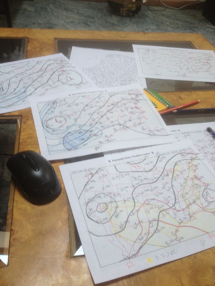
Before jumping into the forecast models, it is very important to look over observational data regaurding the upcoming weather event to get a feel of what should happen and what ingredients should be in place. CAPE doesn’t magically develop, wind shear doesn’t just happen to appear over said CAPE for no reason, and surface lows/fronts/dry lines don’t develop because they want to. The sources of all of these ingredients can be picked out ahead of time using observational data, especially when looking at a day 1 forecast. Due to lack of a printer and some time constraints on my part I won’t be printing out raw, unanalyzed plots of the mandatory levels and doing a hand analysis right now, and will have to settle for looking over objectively analyzed data along with water vapor, observed soundings and mesoanalysis images from this evening.

current wv

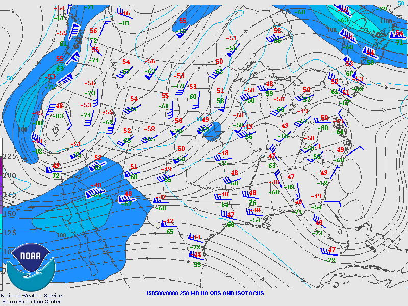
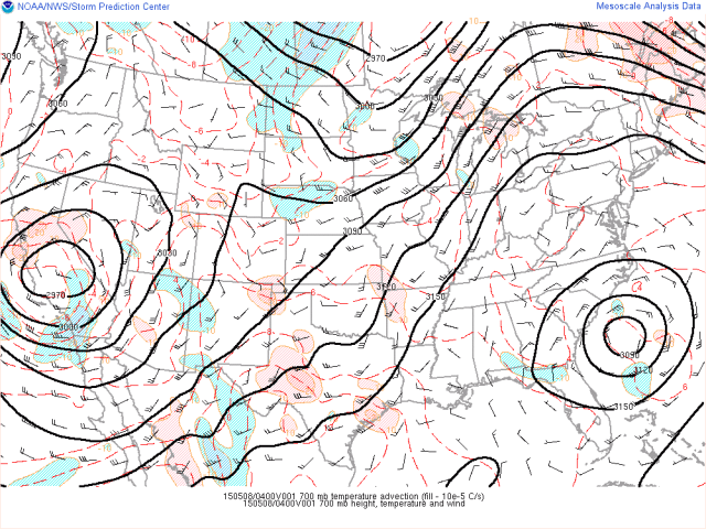
Current water vapor imagery shows an upper level low pressure system slowly moving SE over California. The low appears to be approaching the base of the trough it is located in, meaning it should begin moving more east than south soon. The low is very slowly moving in water vapor loops, suggesting it probably won’t eject into the Plains until Saturday.

To the southeast of the upper low, a speed max and diffluent flow aloft is evident over the four corners region. A subtle speed max was evident over OK/TX when looping the water vapor which helped convection develop in that region Thursday afternoon and evening. As the upper level low slowly moves east over the next day, the diffluent flow aloft should also move east and emerge over the southern Plains on Friday.

current 250

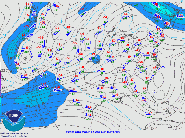
250mb objective analysis valid at 0z Friday shows a similar picture to the water vapor imagery, with a clear speed max and diffluent flow aloft over the four corners region. This will likely eject over the southern Plains on Friday as the upper low and trough slowly move east.

current surfacec

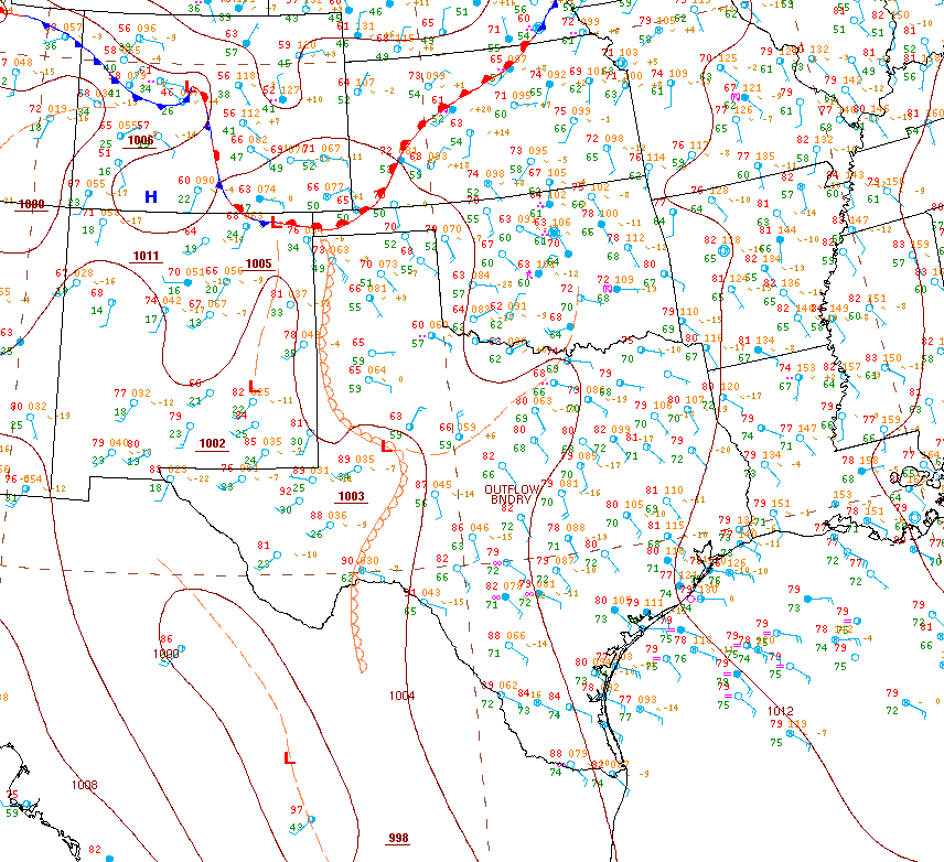
Surface analysis courtesy of the WPC valid 0z Friday shows a weak lee trough/dry line across western TX. Given the bulk of the upper level ascent associated with the speed max is still generally west of this area, the weak nature of any attempt at a lee side cyclone makes sense. However, as the upper level ascent associated with the nose of the speed max and diffluent from aloft with the speed max spreads east on Friday, it is likely that a better attempt at lee side cyclonegenesis will occur on Friday over the southern plains.

The surface analysis also reveals an outflow boundary from convection that occurred on Thursday stretching from west-central TX east-northeast towards the Red River and into south-central OK…south and east of this boundary, surface winds are S-SErly with dew points ranging from the mid 60’s to the lower 70’s, with winds coming off of the Gulf of Mexico where dew points are in the low to mid 70’s. North of this boundary, winds are generally easterly and the atmosphere appears to have been overturned by convection, with much cooler temperatures and dew points.

This sharp of an outflow boundary, with a distinct temperature and moisture difference across it won’t disappear overnight and may act as a pseudo warm front on Friday that both focuses convection and perhaps limits the northern extent of instability, depending on ongoing convection Friday morning and the strength of the low level flow.

Unfortunately, 0z Friday soundings from OUN and FWD still haven’t come in or are just unavailable (it’s 4z as of this writing so I’m leaning towards the latter), which makes it difficult to ascertain the influence of Thursday’s convection on the environment north of the outflow boundary; however, soundings to the south and west can be used to assess the moisture and lapse rates that will be available for Friday:

CRP sounding

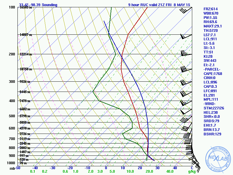
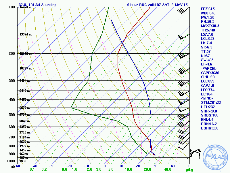
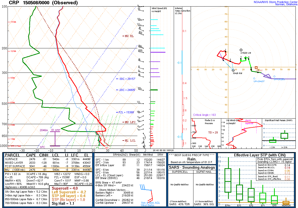
Soundings from BRO, CRP, LCH and SHV all reveal a deep layer of rich moisture (to at least 850mb)…with CRP shown above as it is the closest 0z sounding on the “warm” side of the outflow boundary and east side of the dry line to the target area for Friday. SSErly low level winds at CRP suggest this moisture rich air will be moving towards north-central TX and central and perhaps western OK.

The low level moisture advection is rather weak (note only 10-20 knot winds in the low levels on this sounding), however per the surface analysis above rich moisture exists as far north and west as the dry line and outflow boundary from Thursday’s storms. This layer of moisture is deep enough, with a strong enough cap at the bottom of the elevated mixed layer (EML) that the moisture shouldn’t “mix out” with daytime heating on Friday. This suggests that moisture will be high enough to maintain LCLs that aren’t too high for tornadoes on Friday…and also suggests that low surface dew points won’t limit instability in the warm sector.

current MLCAPE

There is already a fair amount of CAPE on the CRP sounding pictured above, however mesoanalysis suggests that extensive overturning from today’s storms has significantly limited instability in northwestern TX and pretty much all of OK. Moderate buoyancy exists south of the outflow boundary and east of the dry line, however recovery farther north will be needed for the SPC day 2 moderate risk area to verify.

MAF sounding

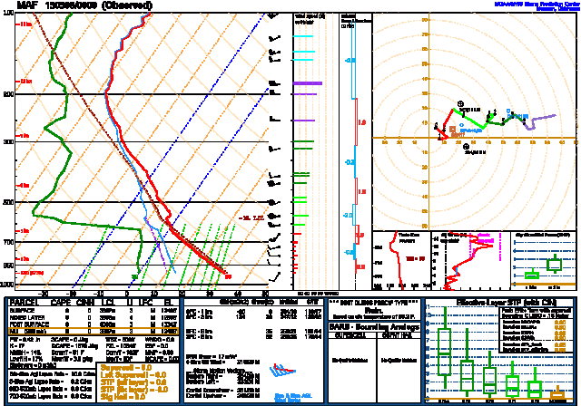
In that respect, 0z Friday soundings from MAF, AMA, EPZ and ABQ reveal a very deep layer of steep lapse rates extending from the surface at those sounding locations to 500-600mb, with 20-30 knot WSWrly winds above 700mb at all four of these locations, suggesting the steep lapse rate air in the mid-levels will be advected east and potentially make it to the east of the dry line by Friday. Steep mid-level lapse rates are crucial for strong, sustained updrafts associated with higher end supercells, and can help buoyancy recover quickly if they advect into an area that has suffered convective overturning from the previous day’s thunderstorm activity.

Farther north, another potential focus for storms on Friday will be a stationary frontal boundary delineated on the surface analysis above. The 0z sounding from DDC reveals respectable mid-level lapse rates well north of the overturned airmass over OK, but just a skin-layer of respectable moisture. This suggests that locations well north of the OFB may see high LCLs are heating and mixing “bring down” lower dew points on Friday, which could limit CAPE and tornado potential once you get well into KS/MO.

current radar

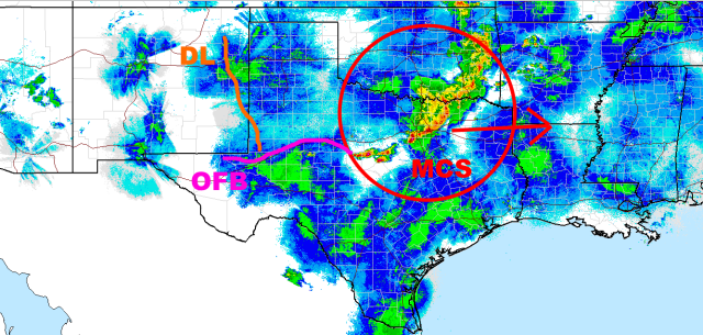
Speaking of which, the thunderstorms from Thursday have developed upscale into a mesoscale convective system…this is moving east and I don’t think will really be in the way for anyone in TX or OK come morning. The OFB is evident on surface obs and radar loops and a roughly sketched in its 4z position on the radar image above…the OFB was perhaps slowly drifting north, and this should continue thanks to the modest southerly low level flow in the area. The dry line has retreated back to near the TX/NM boarder.

My main concern is potential nocturnal convection developing along/just north of the outflow boundary by Friday morning possibly retarding the boundaries push north and possibly influencing later storms if the elevated convection is persistent.

700mb meso

Current mesoanalysis (4z Friday) shows some mid-level warm air advection across parts of west-central TX. You would normally think “oh great, the EML is advecting east and the airmass is recovering behind the MCS” and that is true…however, this mid-level warm air advection can cause elevated thunderstorms to develop overnight into early Friday on the cold side of the OFB and potentially keep the OFB suppressed south of the Red River. Recent HRRR runs develop this elevated convection by early Friday and the very steep lapse rates observed on the 0z Friday MAF sounding support the notion of elevated convection.

This elevated convection could keep the threat farther south than what models that don’t show elevated convection would imply.

So, let’s summarize what we can imply from just the observational data and no real model input up to this point:

-Deep low level moisture slowly advecting NNWward south of an OFB left by Thursday’s storms combined with a stout EML advecting ENEward off of the southern Rockies supports moderate to strong CAPE in the warm sector east of the dry line and south of the OFB on Friday.

-Large scale ascent on the nose of an upper level speed max/jet streak should overspread the southern Plains on Friday. This will support a better lee cyclone on Friday than on Thursday, suggesting a somewhat stronger low level flow. This may help the OFB move north from its current position, potentially into or through OK. This will also support a decent intensification of the low level jet Friday evening. Modest pressure falls may also support backed low level winds to the east of the dry line. The combination of strong Wrly winds associated with the jet streak and potentially backed low level winds in response to the developing lee cyclone likely over the southern Plains should lead to enough westerly bulk shear for supercells…and enough low level shear and turning for tornadoes by evening as the LLJ ramps up as it typically does every evening in a Plains warm sector.

-The potential for elevated convection north of the OFB developing by Friday morning may retard the boundaries progress northward. Ongoing convection may cause the storm mode to be messy. Otherwise, westerly shear vectors across a north-south oriented dry line combined with a cap due to the EML suggest storms would initially be discrete supercell…with some upscale growth into an MCS or two during the evening possible due to respectable large scale ascent and also an intensifying nocturnal LLJ. Given the potential for elevated convection developing early, there is some doubt on discrete supercells occurring.

-Well north of the remnant OFB, along the stationary front (that should turn warm on Friday in response to a deepening lee cyclone and associated low level wind response) in KS and MO decent lapse rates but a lack of moisture may allow some severe threat to play out…however the tornado threat may be lower due to somewhat weaker buoyancy and higher LCL heights due to lower surface dew points.

-The dry line is currently well west along the TX/NM boarder…thanks to ascent shifting east I’d expect the dry line to shift east on Friday as well. However, it is starting fairly far west, so a severe threat could exist back into far western TX/OK (the Panhandles).

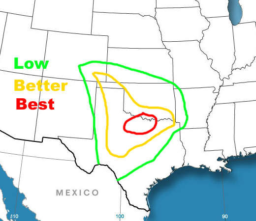
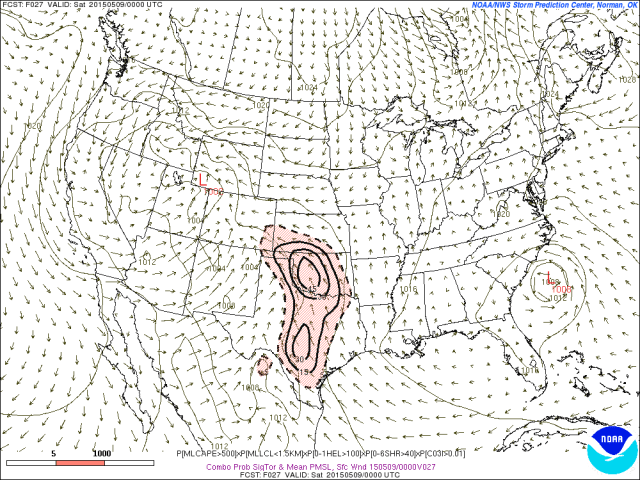
With all of the above taken into consideration, before I look at the models, here is a rough sketch of where I think the best tornado threat may occur on Friday:

severe 1

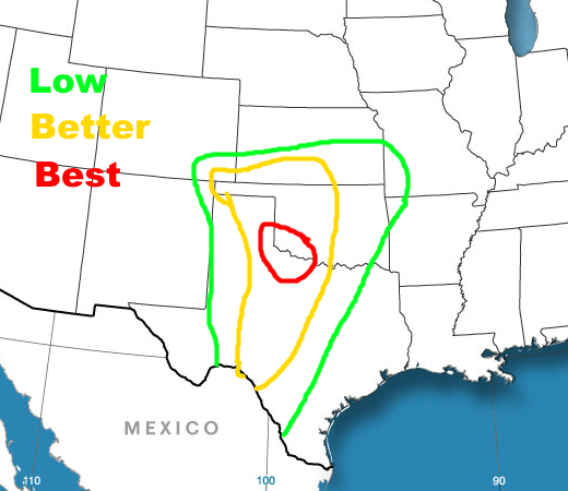
This I believe is fair as it takes into account the possibility of the OFB lifting well north given the strengthening Srly low level flow…but also gives weight to potential elevated convection in the morning keeping it farther south. This also includes some risk up to the stationary/warm front n SE CO/KS/SW MO. If I had to assign SPC style probabilities, the green would be 2%, yellow 5% and red 10%. Although the environment looks good, uncertainties regarding early convection make it harder to go any higher than the 10% odds within 25 miles of a point of seeing a tornado.

Let’s look at some models:

sig tor ingred

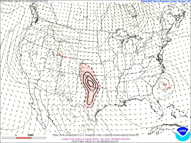
Starting off with the SREF “significant tornado ingredients” parameter valid at 21z Friday (it’s a joint probability among the ensemble members of having a “low end” significant tornado environment with convective precip in place), you can see that a good number of members have ingredients in place over western OK and parts of NW TX. By this point the SREF mean doesn’t develop a true lee cyclone (perhaps an attempt over SE CO), but there is a clear dry line extending from SE CO through the TX panhandle south into south-central TX…a clear stationary front across central KS into northern MO…and perhaps a remnant OFB of some sorts over central OK (note the chance in wind speed in that area).

The wind field makes sense given the observational data discussed above and inferences made from that data…however I am concerned that the OFB may stay a bit farther south than this for reasons discussed above.

sig tor ingred 2

By 0z, the SREF mean shows surface winds backing some across the warm sector in OK and TX, resulting in stronger low level shear and a slight increase in probabilities across the board. This is reasonable as the low level jet typically intensifies in the evening and surface winds also seem to back some in the evening…especially if pressures are falling.

SREF sig tor 3

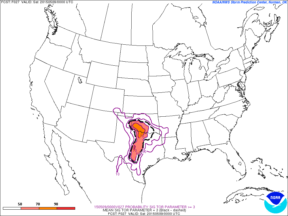
When looking at the probability of the significant tornado parameter being greater than 3, according to the SREF valid at 0z Saturday, you can see high probabilities near the area I outlined above, with better than 50/50 probabilities extending down the dry line in TX. Given the potential for strong CAPE, strong bulk shear and improving low level shear during the evening, this sort of parameter space isn’t unreasonable in my opinion.

NAM 21 250

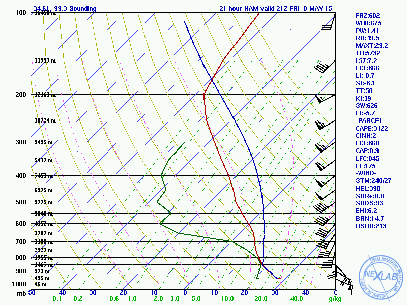
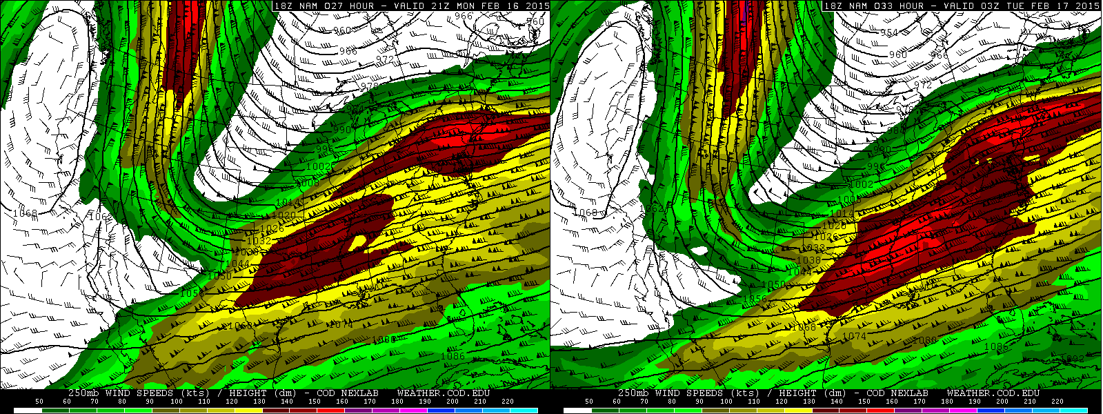
When looking at the 0z Friday NAM; at 21z, as expected based on the observational data looked over above, upper level diffluence/large scale ascent is evident over OK/north-central TX as a speed max ejects out over the Plains. This helps favor a weakening of the cap associated with the EML and storm initiation. My one concern is that this large scale ascent spreads over the dry line over western TX before 18z, which could combine with potential ongoing elevated convection to cause a messy situation.

NAM s

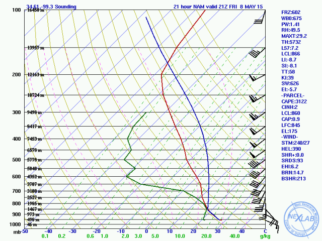
A forecast sounding from the NAM valid at 21z along the Red River in far SW OK shows strong buoyancy, respectably low LCL heights, good low level turning and sufficient bulk shear for supercells, and no cap. This sounding would suggest that storms would fire and that any discrete storm would be a supercell capable of very large hail and a tornado.

I am skeptical about the lack of a cap based on the strong EML advecting east…however, the backed but fairly weak low level winds near the remnant outflow boundary, strong CAPE and strong bulk wind shear make sense based on the observational data discussed above.

NAM STP 24

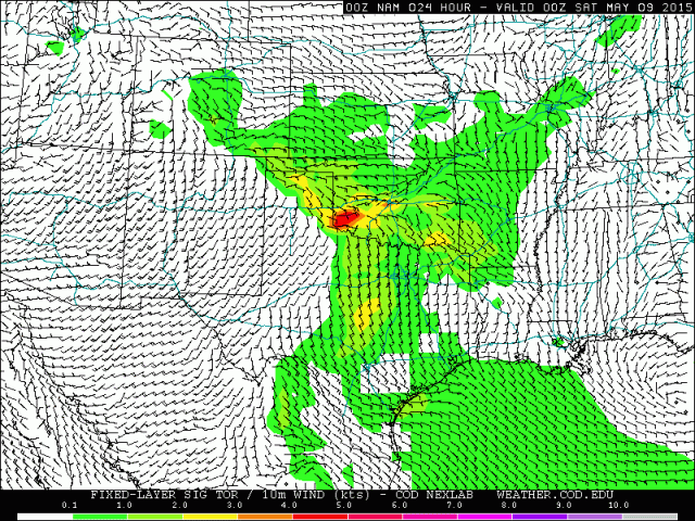
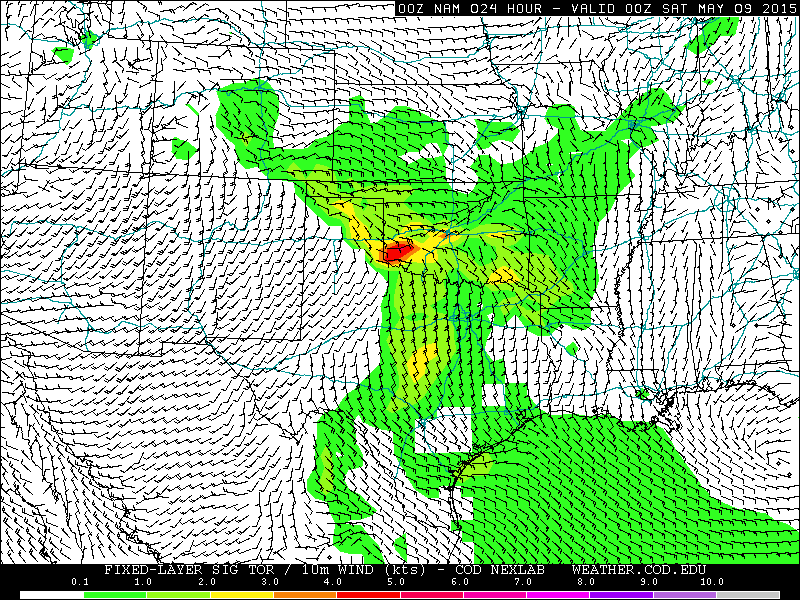
By 0z, the NAM has a nice bullseye of fairly high significant tornado parameter values along the OFB across central OK. Given the likely ramp up of the low level jet Friday evening and expected good deep layer shear and good low level turning along the outflow boundary along with strong instability, this makes sense.

GFS s

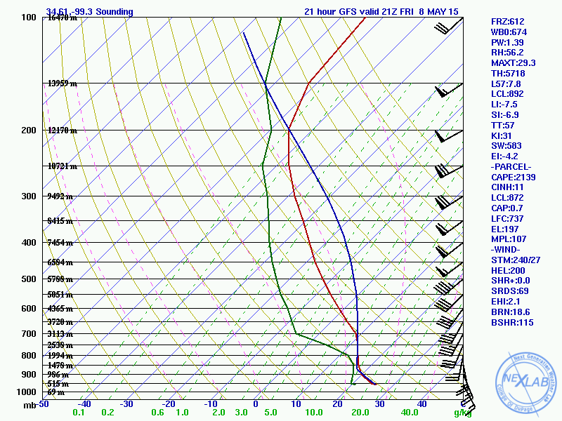
A sounding off of the 0z GFS valid at 21z Friday for the same location as the NAM sounding is fairly similar, however the low level winds aren’t as backed and there’s a little less CAPE. The GFS shows some hint of a cap beneath the EML which conceptually makes sense. This sounding probably wouldn’t stop storms from firing, but would require some source of mesoscale lift to get it done. With a dry line and remnant OFB likely in place, we should have that source of lift.

GFS 21 sfc

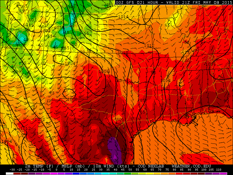
The 0z GFS appears to lift the OFB north quicker than the NAM and SREF…by this point, it appears to be near the KS/OK boarder. I’m skeptical of this due to the potential for elevated convection to fire early and keep the OFB from moving north quicker.

At the end of the day, I don’t see anything on the models to make me change my rough estimate map posted above. I believe that capping associated with the EML will make surface based storms most likely to fire near the OFB/dry line intersection early to midafternoon…however, early day elevated convection may keep the OFB farther south. This places parts of the eastern TX Panhandle and locations near the Red River in NW TX and SW OK in the line of fire. Shear may be locally enhanced by the OFB locally increasing the tornado threat. Instability and bulk shear will support supercells capable of very large hail in addition to tornadoes. If elevated convection is persistent it may make it harder to see discrete supercells here and shrink the “best” tornado risk area even more or even eliminate it. We’ll know more in the morning Friday.

Farther south along the dry line, large scale ascent may be somewhat weaker due to being in a less favorable quadrant of the jet streak/speed max ejecting into the Plains on Friday, making initiation more questionable. However, should storms fire, steep mid-level lapse rates, good low level moisture and sufficient bulk shear suggest that supercells capable of producing very large hail and perhaps a couple of tornadoes are possible. This threat is more conditional however due to questions over initiation.

Farther north, from central OK into SE CO, southern/central KS and western MO, respectable mid-level lapse rates and more questionable low level moisture suggest weaker buoyancy. However, large scale ascent due to divergent flow aloft and the presence of the stationary/warm front may cause some convection to fire. Sufficient bulk shear may support supercells capable of producing hail and perhaps a tornado or two.

Quick look at Saturday:

GFS 48 250

A stronger jet streak/speed max will eject out into the southern and central Plains on Saturday, with outstanding upper level divergence/large scale ascent over the Plains from NE south through KS, OK and into TX.

Rich low level moisture (dew points well in the 60’s in the entire warm sector) and continued advection east of an EML should again support moderate buoyancy on Saturday in the Plains…and stronger upper level diffluence/large scale ascent should promote strong lee cyclonegenesis potentially over eastern CO that results in stronger low level winds and more favorable low level shear for supercells and tornadoes.

GFS OUN

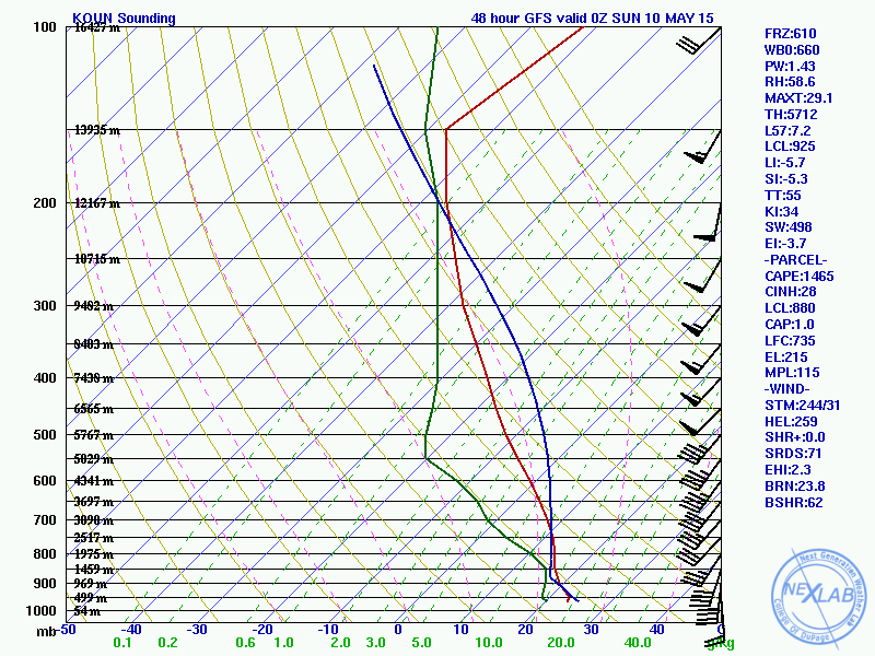
This GFS forecast sounding for OUN valid 0z Sunday shows moderate MLCAPE and very favorable wind profiles for supercells and tornadoes…note the turning of the low level winds and gradual increase with height in the winds.

GFS KS

Farther north in central KS, the low level shear still looks good on forecast soundings however the GFS shows a veer-back-veer wind profile with height, which suggests potentially messy storm modes, which could limit the tornado threat somewhat farther north. Something to consider as the GFS has been consistently showing this. The 0z NAM soundings from the same area also show a hint at VBV winds with height.

SREF sig tor ingr

The SREF significant tornado ingredients probability for 0z Sunday shows that many members are indicating favorable conditions for tornadoes across the Plains…with a stronger lee cyclone over eastern CO, a dry line extending south across western KS/OK/TX, and a warm front extending east across NE/MO.

SREF sig tor 3 sat

The SREF shows respectably high probabilities of significant tornado parameters higher than 3 for Saturday evening as well, meaning many members are coming in with a high significant tornado parameter. Consistency among models can give a forecaster confidence in a call.

Just off of this quick look at Saturday, there will likely be two plays:

  • Near the triple point/along the warm front somewhere in western/northern KS. VBV wind profiles have me somewhat concerned about a messier storm mode here, however low level shear and reasonably good buoyancy otherwise are favorable for tornadoes.
  • Along the dry line in OK into TX. Low level shear will likely be somewhat weaker here…however more favorable wind fields aloft may mean a cleaner and more discrete storm mode. Buoyancy may also be a bit stronger down here.

Ongoing convection may also play a role on Saturday, however it’s a bit early to try to take a stab at that.

Posted in Uncategorized | Leave a comment

4/9/15: Severe Threat Acorss Ohio

SPC 2

The Storm Prediction Center has placed all of Ohio in an “enhanced risk” (risk category 3/5) for severe thunderstorms for Thursday and Thursday night. The potential hazards include:
-Large hail
-Damaging winds
-Flash flooding, especially in central and southern Ohio
-A few tornadoes possible across the state
The best risk for severe thunderstorms will be between 1:00PM and 10:00PM across the state. The entire state has at least some risk for severe weather, however I suspect that southern and eastern Ohio stand the best shot at seeing severe weather.

Some meteorological details:

wpc

The big picture (second image) shows a strengthening low pressure system tracking into the western Great Lakes Thursday evening. This low pressure is expected to push a warm front through northern and eastern OH by Thursday afternoon, allowing the entire state to become warm and humid. The low pressure being strong will result in strong winds aloft and favorable turning of the winds aloft, which supports potential severe weather.

HRRR 1

HRRR 2

The potential fly in the ointment for severe weather will be ongoing showers/thunderstorms Thursday morning potentially limiting how much instability can develop across the state. One of our short term computer models (third image) shows rain and thunder across much of Ohio at 8AM, with some clearing by noon (4th image) across southern and eastern Ohio with more storms moving in from the west. There are multiple clusters of thunderstorms lining up to our west this evening so the idea of rounds of storms seems reasonable. The key to our severe weather threat will be if any clearing can occur between any more rain/storms and the activity expected to either develop or move in during the afternoon. A period of clearing would allow for sufficient instability to develop for severe weather, while no clearing or the afternoon storms moving in too quickly would keep the severe threat relatively minimal.

As alluded to above, I believe the best chance for enough instability to develop will be across eastern and especially southern Ohio…the morning rain/storms may largely miss southern Ohio, and there may be enough of a period of sunshine in eastern Ohio to develop instability. This is far from a certainty, but one of our models supports this idea (5th image).

NAM CAPE

If enough instability develops for strong to severe storms to develop, strong winds aloft and changing wind directions in the lower levels of the atmosphere support the potential for supercells with large hail and perhaps a few tornadoes. The supercell/tornado risk is somewhat dependent on getting scattered storms to develop (as opposed to a squall line), and how exactly the storms evolve is still uncertain…but the potential is there. One of our forecast products, the SREF significant tornado incredients, indicates a 45%+ probability of conditions being conducive for “significant” tornadoes across eastern Ohio at 5PM Thursday based on an ensemble of 20 models (6th image).

sig tor ingr

Again, this is highly contingent on enough instability developing and the storms being scattered and not coming in as a squall line, however some conditional risk for tornadoes certainly appears to exist. I’ll know much more Thursday morning.

Posted in Uncategorized | Leave a comment

3/3/15: Another Southern Ohio Snowstorm

snow 3-4

General discussion:

Colder air will pour into Ohio on Wednesday, changing any rain over to sleet and eventually snow from northwest to southeast during the day Wednesday. By Wednesday evening, another surge of precipitation will affect southern Ohio, and this should fall as mainly or all snow. A long duration moderate to heavy snow event is expected which will result in snow totals of up to a foot near the Ohio River. There is considerable uncertainty on the northern side of things (including Columbus) due to a very sharp northern cut off to the heavy snow. Small variations in the forecast could result in much different snowfall amounts on the northern edge of the snow.

Meteorological Explanation:

When looking over the 0z and 12z model runs and observations from this morning, it appears the trend is for a slightly weaker and slower cut-off ejecting out of the southwest, and also the shortwave moving into the Great Lakes on Wednesday coming in a little quicker. This all argues for the heaviest swatch of snow shifting farther southeast. The 0z GFS captured this considerably better than the 0z NAM. Considering the cut-off still isn’t well sampled, and considering CIPS analog guidance suggests it is very difficult to get heavy snow in the Ohio Valley with this setup, I’m expecting an additional slight bump to the south with tonight’s 0z runs…hopefully I adjusted the map far enough south.

As for exact placement of the amounts, the 12z NAM/GFS/Euro all suggest that 8”+ is very likely across much of southern Ohio. Even with an additional bump south on these models, 8”+ would still likely occur along and just north of the river. Although the NAM and Euro (and even the GFS BUFKIT output) along with several SREF members suggest amounts of up to 15” are possible, I believe that these amounts (if they even occur at all) will be just south of Ohio, as this is where the best mid-level isentropic lift is shown during the storm Wednesday night into Thursday morning. In Ohio, there is still tremendous lift from the right-entrance quadrant of a 200+ knot upper level jet streak from Wednesday PM through Thursday evening, along with high PWATs for a winter storm situation (greater than 0.8” Wednesday evening falling to 0.6” by Thursday morning)…this great upper level lift and high PWAT combo when combined with the duration of the snows (12-15 hours in southern Ohio) and improving snow ratios during the second half of the storm suggests that amounts of up to a foot are possible just north of the Ohio River.

There is good agreement among the Euro/NAM in eroding any mid-level warm layer by Wednesday evening across southern Ohio, with the GFS a few hours faster than that. Most SREF members agree…a few members show rain hanging on in southern OH through much of Wednesday night which shows up in p-type probability plots and skews the mean snow down at sites such as PKB and CVG, however, these members show a ridiculously far north and strong storm track and are being discounted. All in all, feel as though a delayed changeover to snow isn’t a large enough risk to cut down on snow amounts much in southern Ohio.

A very strong northern cut-off to the snow is depicted on all models due to very dry air trying to work in from the northwest. The cut-off depicted on this map is if anything less sharp than the cut-off that some models show, which means the northern edge may need additional trimming at some point between now and when the snow starts if the models continue their south trend. As for the northern edge of the higher amounts…I was very conservative due to the expected sharp cut off, the best mid-level lift staying south of the river and the expected further bump to the south.

Posted in Uncategorized | Leave a comment

2/28/15: Snowy Sunday

snow 2-28

General discussion:

It is the weekend which means another winter storm is a forgone conclusion across Ohio…

Snow will spread into the state rather quickly between 11PM and 1AM tonight. This first wave of snow will persist into Sunday morning with moderate snow at times. During this wave of precipitation, a warmer tongue of air will likely allow for a mix with sleet or freezing rain as far north as I-70…it should be all snow farther north.

There will be a bit of a break in the snow late Sunday morning and early afternoon before another wave of precipitation moves into the state. This second wave will likely fall as rain south of I-70 (or very wet snow near I-70) and snow farther north. Temperatures could warm above freezing as far north as Mansfield, Akron and Warren so this second wave of snow will be much wetter even in northern Ohio which may limit how quickly it can accumulate. This second wave of snow northern Ohio and a mix or rain south will likely persist through Sunday evening before ending.

All told, a swath of accumulations of around 6″ with locally higher amounts is likely where all snow falls…with slightly less right up against Lake Erie where less precipitation will fall. There will be a sharp cut-off in snow amounts south of I-70 due to southern Ohio seeing a prolonged period of rain instead of snow. Travel will be slick at times across the northern 2/3rds of Ohio late tonight through Sunday before gradually improving Sunday night.

Abbreviated Meteorological Reasoning:

After the models sunk south a little bit on Friday, the trend since the 0z Saturday runs has been to drop the shortwave in the Plains in ever so slightly farther west, which allows for slightly higher heights and a better SW flow aloft over the lower and eastern Great Lakes. The majority of the 12z models have responded by beefing up the area of 0.50″+ QPF and bringing the higher QPF a little bit farther north in general than they were on Friday. The Euro, UKMET and SREF mean (when taking out the ARW core) have been most consistent with the placement of the QPF while the CMC has been consistently too far south, the NAM has waffled (and is currently higher than most other models) and the GFS was generally a little too far south but has trended north today.

There are two clear waves of better precipitation expected with this system. Wave one spreads in quickly from west to east between about 11PM and 1AM and persists through early to mid Sunday morning. There is then likely a break or slackening of precip rates for a few hours late Sunday morning into early Sunday afternoon, before wave two moves in late Sunday afternoon into Sunday evening before tapering. Both waves will be primarily focused by warm-air advection between 700mb and 500mb and some PVA with light to moderate precip rates. Wave one looks to hit all of the state fairly well except for NW Ohio…wave two may be focused a little bit inland from Lake Erie. Due to reasons discussed below it wouldn’t surprise me if wave one does much better than wave two in terms of accumulations.

Much of the state should start as snow, however a warm nose is evident at around 925mb on the GFS/NAM/Euro all the way up to near I-70 or even a little farther north in the eastern half of the state late tonight into tomorrow morning. Surface temps will still be below freezing at this point, but the warm layer could be enough to cause a mix with freezing rain or sleet for a few hours in this area. The lift in the low levels and precip rates in general won’t be as impressive as last Saturday’s storm so I don’t expect dynamical cooling to save the day like it did last weekend all the way down to Cincinnati. Behind wave one, warmer surface air will likely move into the state with the low level southerly winds. Again, dynamical cooling likely won’t compensate as much as it did last week and air temps in the mid 30’s could get close to I-70 east of Columbus by Sunday afternoon and surface temps above freezing could get to route 30 or even a little bit farther north. This will likely significantly limit additional accumulations Sunday afternoon and evening near and definitely south of I-70 and may put somewhat of a damper on things as far north as US 30 Sunday afternoon. Temps do cool pretty nicely later Sunday evening but the better precip pulls out at that point, so the bulk of the accumulations along and south of I-70 should come from wave one.

As for actual accumulations…there is excellent agreement on about 0.5-0.7″ of QPF across much of the state, except a little less close to Lake Erie and in NW Ohio and across far southern Ohio. Looking over forecast soundings across the northern third of the state during wave one, the DGZ is rather thin, but there is lift in the DGZ and also a fairly deep isothermal layer near -10C with decent lift in that deep layer through wave one, which should be enough to get better than 10:1 ratios with wave one across the northern third of the state. With warming low to mid levels am expecting near 10:1 ratios with wave one once you get too far south of US 30. The low and mid levels warm a bit further even across northern Ohio which should cut ratios there for wave two down to closer to 10:1. However, average ratios for the event north of US 30 should be better than 10:1, so I followed an average of the ECM/SREF mean (minus the ARW core) 0.5″ QPF line for the separator between 3-5″ and 5-7″ of snow. The 5″ line as drawn also fits nicely with where the heavier precip from wave two should fall. While the NAM, some SREFs and the NMM both spit out a corridor of 0.7-0.8″+ of QPF just north of I-70, due to warming surface temps during the second part of the storm limiting how effectively new snow can accumulate I’m just not confident enough to go with more than 7″ of snow on my map…will mention “locally higher” amounts but leave the range at 5-7″. Amounts taper fairly quickly south of I-70. Near I-70 including Columbus much of wave one should be snow with perhaps a little mix early Sunday so there should still be a few inches…but mixing will significantly cut into wave one accums farther south, and wave two should fall as rain in much of southern OH, so showed a sharp cut off in snow accums just south of I-70 (as there often is).

Posted in Uncategorized | Leave a comment

2/20/15: Significant Winter Storm In-Route for Southern/Central Ohio; Few Inches for Northern Ohio

snow 2-21 no neo

General discussion:

A low pressure system will move from the southern Plains towards Ohio on Saturday. A surge of moisture will cause moderate to heavy snow across southern and central Ohio as this low pressure approaches, with light to moderate snow for northern Ohio. The potential exists for a high impacts in central and southern Ohio due to the wet nature of the snow making it even harder to plow. Uncertainty is highest over Southern Ohio where a mix with sleet, freezing rain or potentially rain may occur and limit snow totals…especially closer to the Ohio River.

Meteorological Reasoning:

HPC low tracks

A low pressure system will track northeast across Ohio Saturday afternoon and evening. A strong southerly flow ahead of this low will bring enough Gulf of Mexico moisture northward for heavy amounts of precipitation east of the low track. The trough associated with this low is weak and positively tilted, suggesting the heaviest precip will be from warm air advection processes to the east of the low. Typically, this kind of low track would bring mixing to much of Ohio and much less snow…however, a very cold antecedent airmass, snow pack as far south as Tennessee and the weakening nature of the low pressure system will combine with heavy precipitation rates (especially in central and southern Ohio) to likely keep a bulk of the precipitation snow. With the amounts of moisture being brought northward, the potential exists for a significant accumulation if the precip can in fact stay mainly or all snow in central and southern Ohio.

current 500

The shortwave that will swing out into the Plains tonight and across the Ohio Valley is currently over the four corners region. There is some confluence over the NE US, however due to a lack of a –NAO that is pulling away to the east. This would normally give our storm some room to track north, but the meager nature of the shortwave will prevent a strong north push.

There are some differences in the models, with the NAM showing mainly snow for almost all of southern Ohio and more liquid equivalent (1-2”) than the GFS, which shows mixing creeping a bit farther north into the state and has less liquid over southern Ohio (0.75-1.25”). So, I’m going to attempt to see how the models are verifying against reality and how they’re trending to determine what kind of solution is more reasonable:

2-21 animated GIF 1

The above loop is comparing the 12z GFS/NAM valid at 0z Friday evening to the 0z meso-analysis. In general, the two models are reasonably close to the intensity of the shortwave compared to the mesoanalysis. The GFS/analysis appear a bit weaker, but that’s more a product of their lower resolution. The NAM appears to be closer to mesoanalyis with heights to the east of the shortwave and really all the way to the east coast. The GFS is a bit too high with heights, which may help explain why the model shows a slightly warmer solution. The mesoanalysis is a little higher with heights than the NAM, but is much closer to the NAM than the GFS.

2-21 animated GIF 2

This next loop compares the 15z, 18z and 21z RAP valid at 9z Saturday morning, to see if trends in the short term model can shed any light on the situation. The model has noise level changes in heights east of the shortwave, but on the whole trended a little stronger with the shortwave over the Plains. This could suggest heavier precipitation getting a little farther north over the Ohio Valley when the shortwave comes east due to a slightly stronger shortwave and slightly better southwest flow ahead of it.

2-21 animated GIF 3

The above loop is a similar look at today’s NAM runs (through 18z). One change is for slightly lower heights over the east, which suggests the NAM may be trying to trend just a little farther south and colder. The shortwave over the Plains also trended a little weaker on the 18z run. This suggests that the NAM’s very high QPF values getting well north of the Ohio River are overdone (not a shock), but also suggests that a slightly cooler solution is possible, which is critical in the southern third of Ohio as temperature profiles are very marginal there. The NAM, interestingly, was cold enough for essentially all snow except for the southern tip of Ohio even with its farther north precipitation shield.

2-21 animated GIF 4

The GFS loop is very interesting. It is extremely consistent with the shortwave, but is consistently trying to depict high heights over the eastern US each run. The GFS is currently the warmest model, but appears to be going against observed heights at 0z and the NAM trend. The NAM appeared to be doing best through 0z.

All told, considering the NAM appears to be correcting a bit weaker with the shortwave, but is otherwise doing well with the height orientation over the eastern US, I’m going to lean towards a GFS/NAM blend for QPF amounts and lean towards the NAM for temps for this forecast. The

Just took a peak at the 0z NAM and it came in with a little less QPF and slightly colder temps.

As for p-type, snowfall placement and snowfall amounts, let’s dive in!

NAM 250

There will be very impressive upper level divergence across the Ohio Valley thanks to two jet streaks working in tandem. We will be in the right-entrance quadrant of a jet streak to our north, and the left exit quadrant of a jet streak to our south, with clear upper level divergence on the image above. Note how the wind barbs “fan out” over the Ohio Valley…also note how there are two areas of stronger winds splitting apart. This indicates strong large scale lift across the region for much of the day Saturday.

NAM 500

At the same time, a decent little speed max at 500mb with the vortmax/shortwave moving across the Ohio Valley will also cause a period of increased lift as it moves overhead. Decent lift at 500mb appears to occur off and on from late Friday night through much of Saturday afternoon. Check out the 500mb vertical velocities associated with this feature:

NAM 500 vv

There appear to be two waves of precip. The first wave is associated with strong 500mb vertical motion (left) early Saturday, with the second one just a little farther south for Saturday afternoon.

NAM 700 wind

Looking into the low to mid-levels, a very impressive jet will transport copious amounts of warmer/more moisture laden air northward into the Ohio Valley ahead of the surface low pressure. The nose of a very strong jet at 700mb will move into southern and central OH late Friday night into early Saturday. There will likely be an intense period of precip that yes is convective as that noses in. The stronger 700mb winds shift south towards the Ohio River by Saturday afternoon, however there should still be some warm-air advection and hence lift at that level across far southern (especially SE Ohio) Saturday afternoon, which along with the aforementioned upper level support suggests moderate to heavy precip continuing in this area Saturday afternoon. The initial surge of warm air advection at 700mb should get far enough north for a burst of moderate to heavy snow as far north as US 30 Saturday morning and light to perhaps moderate snow as far north as Lake Erie, especially east of Sandusky.

NAM 850 wind

Looking at the 850mb level, there is a very impressive low level jet here transporting in warmer and more moisture laden air into much of southern and eastern OH. The nose of the 850mb jet corresponds to both the nose of the 700mb jet and the first surge of 500mb lift Saturday morning…the stars are aligning for a burst of heavy precipitation in southern/central OH Saturday morning. Even through Saturday afternoon, the northern portion of the low level jet should continue to supply some boost to the precipitation over southern and eastern Ohio, although not to the extent it will in the morning.

NAM theta

When looking at another product at 850mb, theta-e, which is a product of temperature and water vapor, is increasing markedly across southern Ohio on the nose of this low level jet. Warm air advection naturally features rising motion, and as this warmer/higher water vapor content air converges on the nose of the low level jet, it is forced to rise quickly and produce clouds/precip and in this case potentially heavy precip.

Over southern and central Ohio, there is a good signal from everything discussed above for a burst of heavy precip that lasts a few hours Saturday morning. Given the strength of the low level jet and likelihood of slantwise instability, elevated convection is likely. Maybe a rumble of thunder?? Precip rates of 0.1-0.25” per hour will likely occur for a time with this burst, especially in southern Ohio. As we head into the afternoon, the low and mid level lift weakens some or shifts southeast a little, which should cause a bit of a lull in the precip, especially in central and northern Ohio. Closer to the Ohio River, moderate to perhaps heavy precip should continue through the afternoon.

By mid to late afternoon I expect another surface of better precipitation as a few things happen…the vort max moves across Ohio, we get back under the right-exit quad of a jet streak, and as the surface low/trough passes. This should cause one more uptick across central and northern Ohio. This burst of precip may actually be a little longer lasting and intense in northern Ohio, as the morning burst looks like more of a graze job up there.

NAM PWAT

There will be a fair amount of Gulf moisture streaming north, with precipitable water values of 0.7” getting to the Ohio River on the 0z NAM by Saturday afternoon. The combination of relatively high precipitatble water values and a good 12-15 hours of decent upper level convergence (it isn’t as favorable briefly around noon across the state, but is before and after) leads me to believe that the high QPF values aren’t unreasonable, especially across southern OH where low level lift will be the strongest for a longer period of time.

QPF

The NAM is generally more aggressive than the Euro and GFS with QPF. The GFS and Euro agree well, however what I discussed above does suggest increasing QPF a little bit over the GFS and Euro over central and especially southern Ohio.

How much of this falls as snow?

GFS temps

A warm nose will attempt to move north between the surface and 850mb in the warm air advection during the day Saturday. As it stands now, except for right along the Ohio River, the GFS and NAM appear to keep 925mb temps and 850mb temps below 0C through the duration…except for perhaps a brief warm nose trying to work in at times within 20 miles of the river at 850mb during the stronger warm air advection at that level.

GFS sfc temp

At the surface, temperatures re modelled to rise to above freezing across a good portion of the state, but just barely…generally 32-34 degrees.

The NAM and Euro are both a little colder than the GFS, with a general cooler trend in the models noted today.

SREF ptype

In addition, the 21z SREF members for Parkersburg show that except for a couple of members that work in enough warm air aloft for a little bit of mixing during the stronger warm air advection in the morning, almost all members keep the precip type snow until later Saturday evening. The SREF are known for being too far northwest with system, too moist and too warm, so it’s encouraging that most of them keep PKB all snow.

On the balance…with every model keeping low to mid level temps at or below freezing (except for the GFS which warms by evening) for all areas just north of the Ohio River through the heaviest precip…aside from perhaps a brief warm nose at times at 850mb near the river…the recent cooler trend in the models…and the likelihood of convective precip which suggests dynamical cooling during the heavier precip rates helping the process…am going for mostly snow more than 10-20 miles north of the river, with a mix and less snow very close to the river.

As for amounts, ratios will not be great across much of the state due to a narrow dendrite growth zone and a fairly deep near freezing layer from the surface up to about 5,000 feet…along with the potential for surface temps to rise to 32-34 during the snow across much of central and southern Ohio. Ratios across northern Ohio of 10-12:1 seem doable, 8-10:1 in central Ohio, and 7-9:1 in southern Ohio. There will be impressive lift in the rather thin dendrite growth zone so flakes probably won’t be small, however the deep layer of near freezing temps make me very hesitant on higher ratios.

With good agreement on a quarter to half inch of QPF across much of northern Ohio, to go along with decent upper jet support and some modest low to mid level lift at times during Saturday, believe 3-6” seems reasonable here. The best chance for 5-6” will be near and south of US 30 where strong mid-level lift may cause a fairly decent burst during the morning. In central Ohio went with slightly higher QPF than GFS/Euro and figured half to three quarters of an inch given a good shot of moderate to heavy precip during the morning and another couple or few hour shot of moderate precip mid to late afternoon. This gives 4-8” of snow here. In southern Ohio I expect over 1” of QPF south of a CVG-RZT (Ross County)-HLG (Wheeling) line, with around 1.25” near the Ohio River east of HTS. This axis of 1”+ QPF matches with where at least moderate precip may not stop during the afternoon, and the heavier amounts near the river correspond to where the strongest low to mid level lift will persist during the afternoon. This QPF distribution is essentially a NAM/GFS blend in southern Ohio.

With very wet snow but mainly snow, this supports a corridor of widespread 6”+ amounts to locally 10” south of a Hamilton-Circleville-Wheeling line…I expect mainly or all snow here and over 0.75” of QPF. Along the Ohio River, will go less as I do believe that enough of a mid-level warm nose will be present to cause frequent mixing here.

This will be a very high impact storm over southern Ohio due to the heavy wet nature of the snow making it difficult for crews to clear the roads. Areas that see over 6” of this snow may see a few trees down and isolated power outages.

Posted in Uncategorized | Leave a comment

2/15/15: Southeast Ohio Finally to get Snow

General Discussion:

SE Ohio base map

Light snow will overspread Athens around noon on Monday. The potential exists for a few hours of somewhat heavier snowfall during the mid to late afternoon, with light snow then persisting through Monday evening. The snow should end after midnight Monday night. The snow will be fluffy and accumulate fairly efficiently, however the somewhat short duration of heavier snows makes it uncertain whether or not more than 6″ can fall. Winds will generally be light, so blowing snow shouldn’t be a large concern.

Detailed meteorological reasoning:

After the vast majority of chances for heavy snow for Athens and SE Ohio have missed to the north, south, or just disappeared so far this winter, it appears that a shot of moderate snow may finally affect the area Monday into Monday night.

current 500

A shortwave is diving southeast through the Rockies this afternoon, with some moisture bring drawn eastward from a cut-off low over the Baja of California. With a rather flat shortwave ejecting into the Plains tonight into Monday and a very strong Nor’easter currently acting to cause lower heights along the East Coast and strong confluence aloft over the Ohio Valley and southeast, the main concern for Southeastern Ohio won’t be if the precipitation will fall as rain instead of snow, but more along the lines of how far north the heavy snow with this storm can make it.

500 NH

When panning out to the entire hemisphere now, there is some hope for the mess off the East Coast to get out of the way. There is no –NAO, in fact it is strongly positive due to lower heights over Greenland and Iceland. There is still plenty of room for the Nor’easter to swing out well to the northeast over the next day, and in fact when comparing the map from 12z/8AM Sunday for the hemisphere to the closer in map from 20z/3PM of the US, you can see that the trough with the Nor’easter has already swung off the New England coast, with heights rapidly riding to the west.

Considering the lack of a –NAO, it is not surprising that our models went from keeping any snow well south of Ohio to trending north and threatening to bring decent snows to Athens as soon as the shortwave responsible was sampled by RAOBs over North America…it is not uncommon for these pieces of energy to come in a little stronger than thought compared to when they’re out over the Northern Pacific where there isn’t as much good data going into our forecast models.

The ridging on the West Coast is also very stout, which does suggest our shortwave digging a good amount and potentially partially phasing with the sub-tropical jet before ejecting out into the Plains tonight into Monday.

So yes, the models have trended north a fair amount over the last 24-36 hours with respect to the track of the surface low and precipitation field, and most do show at least some accumulating snow for Athens. However, it is important to figure out exactly which models are right, if there will be another trend back north or perhaps a bump south, and what kind of snowfall amounts the dynamics with the storm system suggest could happen.

animated GIF 1

First I am going to compare the 12z runs of the GFS/NAM valid at 21z this afternoon to the 21z mesoanalysis using 500mb height/vorticity. In general, the 12z GFS is closer to reality than the 12z NAM. The GFS is very close to the analysis with heights over the eastern US, and is a little less amplified with the shortwave diving into the southwest US. The NAM is both too slow to move the Nor’easter off to the east and hence too low with heights over the eastern US, and also not digging the shortwave quite far enough southwest over the western US. One interesting note is neither model is quite strong enough with the little vortmax over Minnesota, which could make a small difference later.

animated GIF 2

Although the “long range” RAP (towards the end of the run) shouldn’t really be used for a deterministic forecast, trends in the RAP as it gets closer to verification time can potentially shed light on how the model is handling a situation. I’ve compared the 12z, 15z, 18z and 21z RAP runs valid at 6z Monday at 500mb in the animated GIF above. Note how the 12z run was definitely too slow to eject the eastern US and had heights that were too low over the eastern CONUS…although that generally steadied out or became a very slow trend by the last two or three images. Much like this morning’s models, the shortwave appeared to be modeled to not dig far enough into the SW CONUS on the 12z and 15z RAP…again though, the last two runs were much closer together. The small feature over Minnesota discussed above is expected to be over Lake Superior tonight, and it should be noted that there was a slight trend to move that feature farther south on the RAP as we get closer to verification time…which could make a very small difference in the heights across the Great Lakes.

Because the differences between RAP runs is decreasing as we get closer to verification time, I believe it is fair to compare the 18z GFS/NAM and 12z Euro to the 21z RAP valid 6z Monday to determine if the ­NAM/GFS/Euro are close to the stabilizing RAP at 6z:

animated GIF 3

In general, you have to squint to see differences. The Euro and GFS appear to be close to the RAP in terms of how far southwest the shortwave digs over the Rockies. The NAM is similar in height configuration but noticeably farther northeast with the highest vorticity. In the east, the Euro and RAP both appear to be pulling the Nor’easter (based on the 498dm contour) east just a little quicker than the GFS/NAM…which is a trend already noted above. Over the Ohio Valley, the GFS and Euro are a smidgen lower with heights compared to the NAM/RAP.

All together…when considering the pattern (no –NAO supports the quicker exit of the Nor’easter and the very stout ridge along the west coast supports our shortwave digging more aggressively into the SW US before ejecting into the Plains)…and the trend in the models to continually move the Nor’easter east faster…along with the trend (that is starting to end) to amplify the shortwave diving into the southwest more before it ejects…I’d be inclined to believe a south trend is unlikely. The vort max over Lake Superior gives me a little bit of concern, however the GFS/NAM/Euro are currently handling that similar to the recent RAP run. The Euro appears to be leading the way with moving the Nor’easter east (it was much farther north with the storm than the GFS/NAM in last night’s 0z run and stayed very steady in today’s 12z run with perhaps a very small shift south)…and the GFS and Euro appear to be handling the more aggressive digging of the shortwave into the southwest better.

The 18z NAM is fairly close to the GFS/Euro, so I’ll favor a blend of the three models for this forecast. With the Euro appearing to lead the way with the north trend compared to the GFS/NAM, I’ll give its slightly farther north solution a little bit more weight.

Animated GIF 4

When looking at the Euro, NAM, GFS and RGEM (essentially the Canadian version of the NAM, it’s not much worse than the NAM itself), all four models show 0.3” or more of liquid QPF for Athens. The RGEM and NAM appear to be about 0.3-0.4” of liquid, and the Euro about 0.5” of liquid, while the GFS is probably about 0.3” on the dot. Snowfall isn’t model QPF times 10, contrary to the somewhat popular belief (its snow rate times duration), however you can see a few things:

-All four models bring a half decent amount of QPF to Athens

-There will be a fairly sharp northern cut off to the snow

-If the NAM/GFS/RGEM shift any farther north, they could bring “Euro like” numbers to the area.

I have already been naughty and included a couple of Euro images in this write up, so I’ll look at mainly the NAM/GFS to discuss the dynamics of this storm, when it may snow and how heavily it may snow. In general, the Euro is very similar to the GFS/NAM but shifted 25-50 miles farther north.

WPC low tracks

NOAA’s Weather Prediction Center is forecasting a low track across the Deep South, well south of Athens, with most models agreeing on a similar concept per the map above. So, how will we get snow all the way up into Athens with this low track?

NAM 250

When looking at the jet stream (250mb level) on the NAM, Athens will be in a favorable region of upper level divergence (which is a source of lift) from Monday afternoon into Monday evening. Z time (the time stamps in the upper right corner) is EST plus 5 (Z time is five hours ahead of EDT, so 21z is 4PM EST). Both the right-entrance quadrant of a departing jet streak and left-exit quadrant of a jet streak running to our south will provide large scale lift to the area. This helps explain how there’s a low pressure system running across the Deep South (with the favorable lift on the southwestern side of the jet streak to our south) while there’s snow in the Ohio Valley (with lift from two jet streaks) at the same time.

This period of favorable upper level jet support lasts about 12-15 hours (from roughly late morning Monday till 1AM Tuesday). However, the GFS/NAM show the better mid-level lift staying just south of us, which means we would struggle to see a prolonged period of moderate to heavy snow in Athens.

NAM 700

Often times, heavy snow in winter storms comes from warm air being forced to rise over a colder surface airmass and condensing and forming clouds/snow. This process is most effective on the nose of strong mid-level winds that have a southerly component, as those winds are bringing warmer and more moist air farther north. As can be seen on the left plot above from the NAM valid at 1PM Monday (at the 700mb level), the nose of the stronger mid-level winds is just south of Athens. The mid-level frontogenesis plot on the right (which is a good signal for where this source of lift is maximized) does suggest an area of heightened frontogenesis just south of Athens at 1PM. As is, the NAM keeps the heavier snow with this feature just to our south, as does the GFS. The Euro brings this feature slightly farther north over Athens, suggesting we could get into a period of moderate to heavy snow due to being on the nose of a stronger mid-level jet/mid-level warm-air advection IF the Euro is correct.

North of the best mid-level frontogenesis, any snow would likely be caused by lift even higher in the atmosphere:

NAM 500

When looking at the 500mb plots (which is about 18,000 feet above ground level) for Monday afternoon, one can see there is fairly strong positive vorticity advection over southern and central Ohio (vorticity plot on the left). Positive vorticity advection is a source of lift, and the corresponding 500mb vertical velocity plot on the right at the same time does show upward motion where the stronger positive vorticity advection is occurring.

Both potential sources for heavier snows will be strongest Monday afternoon before dwindling gradually Monday evening, which suggests that if we do see heavy snow in Athens, it will be Monday afternoon, with things starting to taper Monday evening and ending after midnight Monday night. The duration of snow looks to again be roughly 12-15 hours, with the period for potentially more moderate or heavy snows being about 6 hours.

NAM 500 30

Stepping back and taking a bigger picture look at 1AM Tuesday, the shortwave that will be causing this snow will be weak and positively tilted. This suggests that the best sources for lift and hence snow will be positive vorticity advection, upper level jet support and low to mid-level warm air advection…with little wrap around snows. So, we are looking at a 12-15 hour shot of snow, with the best chance for moderate or heavy snow being about a 6 hour window Monday afternoon and early afternoon through early evening, IF the storm can shift north and bring the better mid-level warm air advection closer to Athens as discussed above.

Figuring out when/how long it will snow, how hard it may snow and how much liquid will fall aren’t the only part of figuring snowfall amounts. Snow can accumulate much more efficiently with the right type of snowflakes, which means that one amount of liquid falling as small snowflakes would accumulate much less snow than that same amount of liquid falling as large, fluffy snowflakes.

PKB overview

The most important factors to figuring out what kind of snowflakes will fall are where in the atmosphere will the air be nearly saturated, where in the atmosphere will there be upward motion, and where in the atmosphere the temperatures will be between -12C and -18C (dendrite growth zone).

The plot above for Parkersburg helps us answer those questions. The color fill is relative humidity (bright greens and purples are nearly saturated), the purple and yellow outlines indicate the “dendrite growth zone”, and the red outlines indicate upward motion in the atmosphere. As can be seen above, there is a fairly deep and saturated dendrite growth zone per the NAM over Parkersrburg Monday afternoon and evening, with the strongest lift focused in and above that zone. With cold temperatures at the surface, it is likely that the snowflakes will be fairly fluffy. As is, the plot above isn’t perfect for high ratio snows, but if the Euro panned out, stronger mid-level lift would occur in the dendrite growth zone and lead to higher ratios. Either way, snow to liquid ratios of 15:1 to 20:1 will be likely.

Considering I’m giving slightly more weight to the Euro as discussed above, I am expecting a few hours of moderate snow in Athens mid to late Monday afternoon, potentially into the early evening. Snow rates of half an inch to an inch per hour are possible in this timeframe. There could be a couple hours of light snow before that, and a few hours of light snow after that. This adds up to a few to several inches of snow for Athens. When factoring in snow ratios and modeled liquid equivalent values, amounts range from about 3.5” on the GFS to about 6” on the NAM to about 8” on the Euro. I’m not ready to go “all in” on the Euro QPF due to the quick hitting nature of the storm in general and low precipitable water values. A dry northeast flow ahead of the storm may also eat away at the northern edge of the snows a little bit. However, given a fairly good shot of upper level jet support and lift in upper levels, and the potential for a period of strong mid-level lift and heavier snow if the farther north models pan out, I feel as though a 4-7” snowfall forecast covers the bases well enough for Athens.

Posted in Uncategorized | Leave a comment