2/13/15: Snow and Blowing Snow Saturday; Then Bitter Cold

General discussion:

snow 2-14

A winter storm will bring moderate amounts of snow, significant blowing/drifting snow, very low visibilities for a time and brutally cold conditions to Northeastern Ohio Saturday through Sunday. A significant impact on travel is expected Saturday mid morning straight through to the evening in some areas.

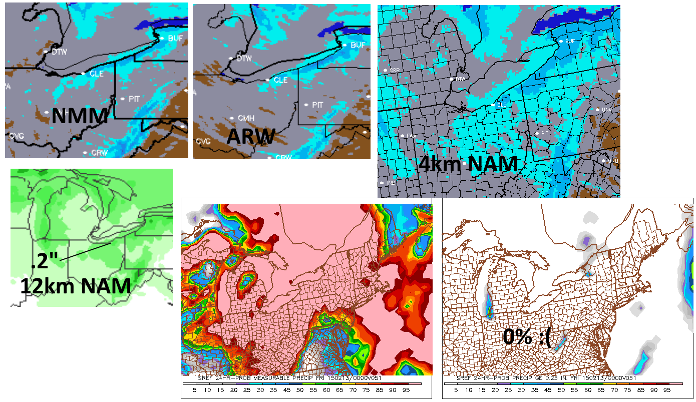
Light snow will overspread northern Ohio overnight tonight. Accumulations of an inch or so will be possible by 7AM, so conditions tonight won’t really be that bad. The snow will become steadier and somewhat heavier Saturday morning with increasing winds. This will culminate in a brief period of blinding snow squalls with very strong winds along an Arctic cold front late Saturday morning or early afternoon. This will cause a widespread 2-4″ of snow to fall through early Saturday afternoon for most of northern Ohio.

Some lake effect snow will then develop Saturday afternoon and persist through Saturday night. The lake effect could add another inch or two of accumulation for the rest of Saturday afternoon from Lorain and Medina Counties points east, especially in the hillier terrain. The best threat for lake effect to continue Saturday night in any kind of significant fasion will be from eastern Cuyahoga County points east where some moisture from Lake Huron may assist the situation. Another couple inches could fall overnight Saturday night here.

travel impacts 2-14

The travel impact could be significant for several hours in the Cleveland metro and Snowbelt (possibly as far west as Lorain and Medina) due to a period of blinding snow squalls and very strong winds. The worst conditions will be from about 10AM to 2PM Saturday, however where lake effect snow continues, very poor visibilities due to falling snow and extensive blowing snow will continue into Saturday evening…a few local areas on the east side could continue with hazardous conditions well into Saturday night. Travel is not advised during the period of heaviest snows and winds.

Neorisk 2-14

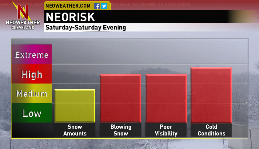
Temperatures will fall below 0 Saturday evening and stay there until Monday morning. Yes, high temperatures on Sunday may not get above 0 (if they do, it’ll be barely). Wind chills will be -25 to -35 at times Saturday evening through Sunday, which could cause frostbite in 15 minutes to half an hour if precautions aren’t taken. Record low temperatures are likely to be broken Sunday and Monday in Cleveland. If Sunday’s high stays below 8 in Cleveland (which is extremely likely), it will break the record for “coldest high temperature” for the date.

Meteorological Explanation:

current 500

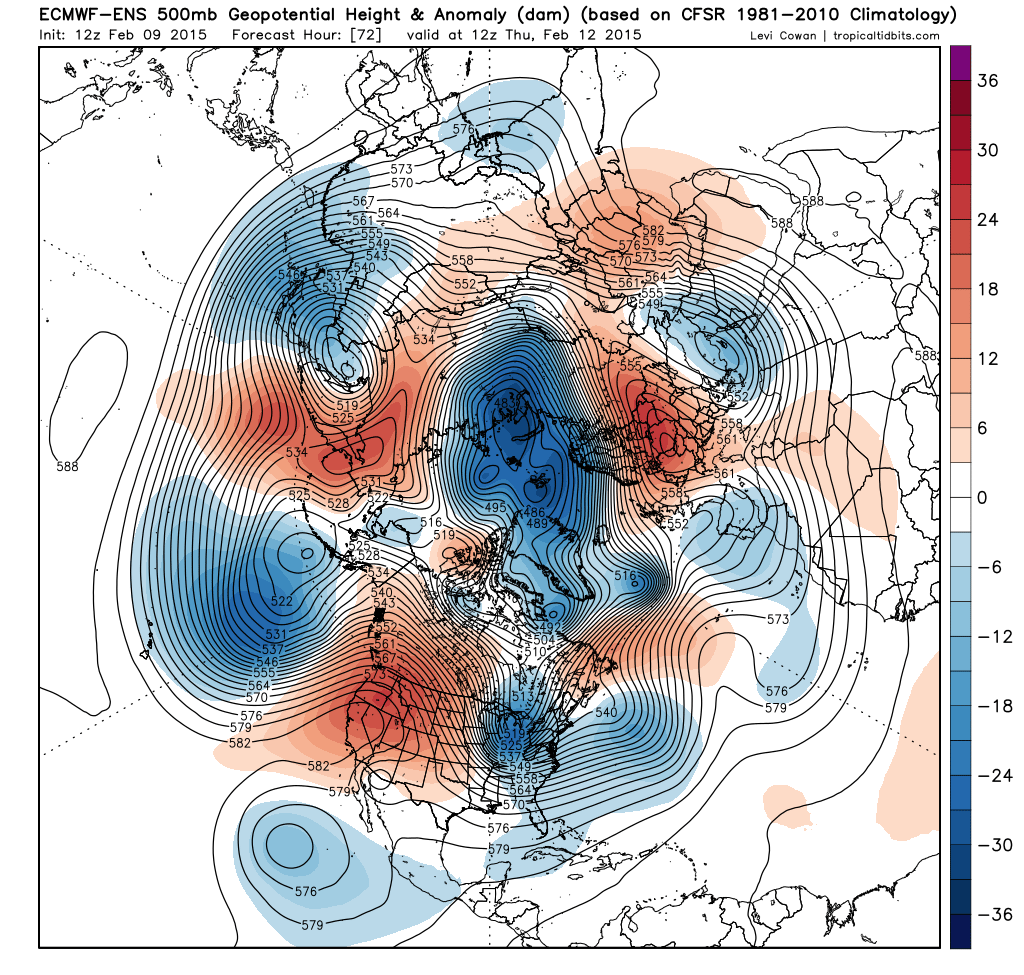
A tall +PNA ridge extending almost to the North Pole is helping facilitate a cross polar flow Friday afternoon, which is allowing frigid air to pour south towards the Great Lakes straight from the Arctic. A lobe of the polar vortex (currently over western Hudson Bay) will drop south through the Great Lakes on Saturday, causing a surface low pressure pictured over Lake Superior above to move southeast and intensify across the lower Lakes. This will cause some light to moderate synoptic snow along and ahead of a cold front that will drop across northern Ohio Saturday morning, and the deep arctic airmass behind the front will help cause some lake effect snow across northern Ohio. Ice on Lake Erie and upstream lake moisture will be critical to the lake effect forecast.

NAM 12

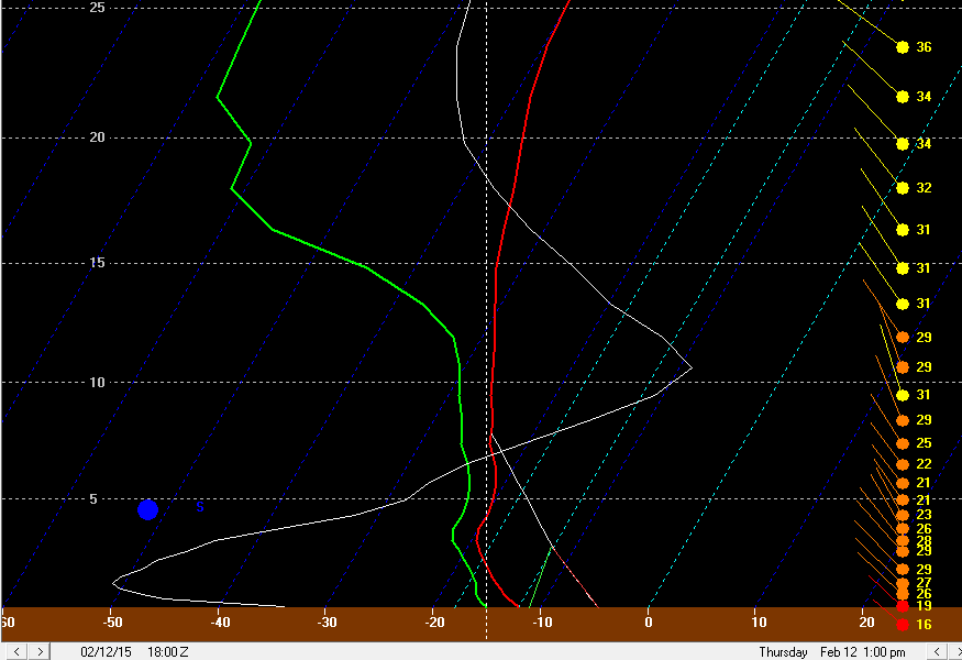
For the remainder of tonight and into Saturday morning, a nice shot of upper level divergence in the left-front quadrant of an upper level jet streak combined with some half decent warm air advection on the nose of a strong mid-level jet will cause light snow across northern Ohio. There could be an inch or so of snow by 7AM Saturday as most models spit out around 0.1” or a little less of liquid precip. Ratios tonight should be 12-15:1 with most of the modest low to mid level lift focused in the DGZ.

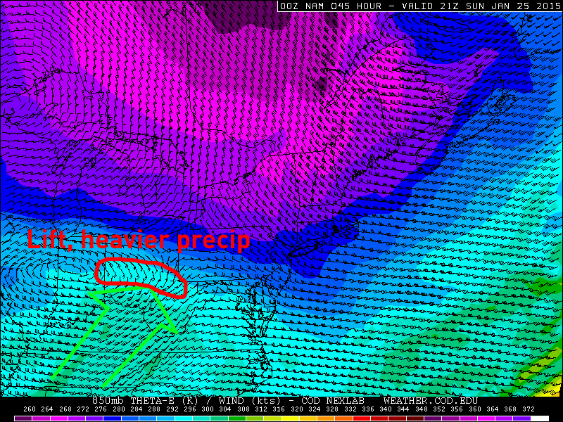
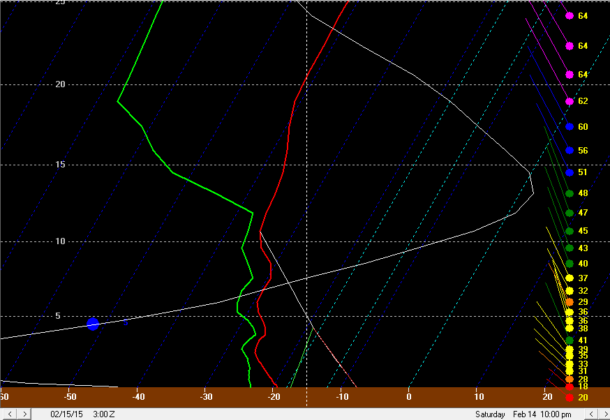
As we head into Saturday, low level convergence will really increase along and immediately ahead of the arctic frontal boundary, and falling mid-level temperatures will result in steepening low to mid level lapse rates and some surface based instability. This will lead to the snow becoming a little more snow showery after sunrise on Saturday, but the snow intensity will also increase. This will all culminate in a brief period (an hour or so) of blinding snow squalls along the arctic front late Saturday morning near Lake Erie and around noon or so farther inland. A look at synoptic model plots and forecast soundings in BUFKIT all suggest a very impressive snow squall potential along the arctic front:

NAM 18 500

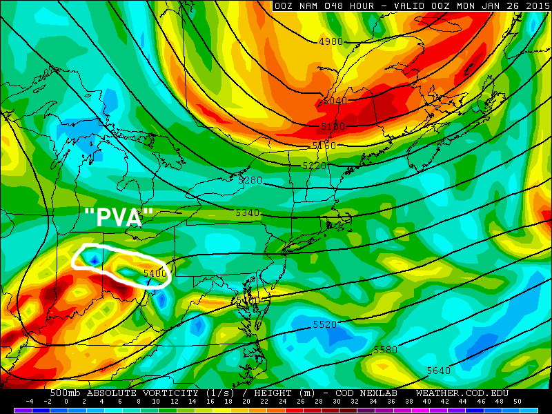
There will be a very impressive shot of positive vorticity advection early Saturday afternoon across northern Ohio (and much of the state really). This is a source of lift and can also help raise equilibrium levels and increase instability.

NAM 18 850

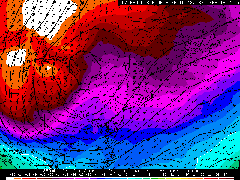
In addition, low level frontogenesis and convergence will be very strong along the arctic front (both sources of lift). Note how at 850mb, there is a very sharp temperature gradient, and also note the sharp and sudden shift in wind direction and increase in wind speeds along and behind the arctic front. These are both sources of convergence and lift that can help an intense snow squall develop.

NAM 18 fronto

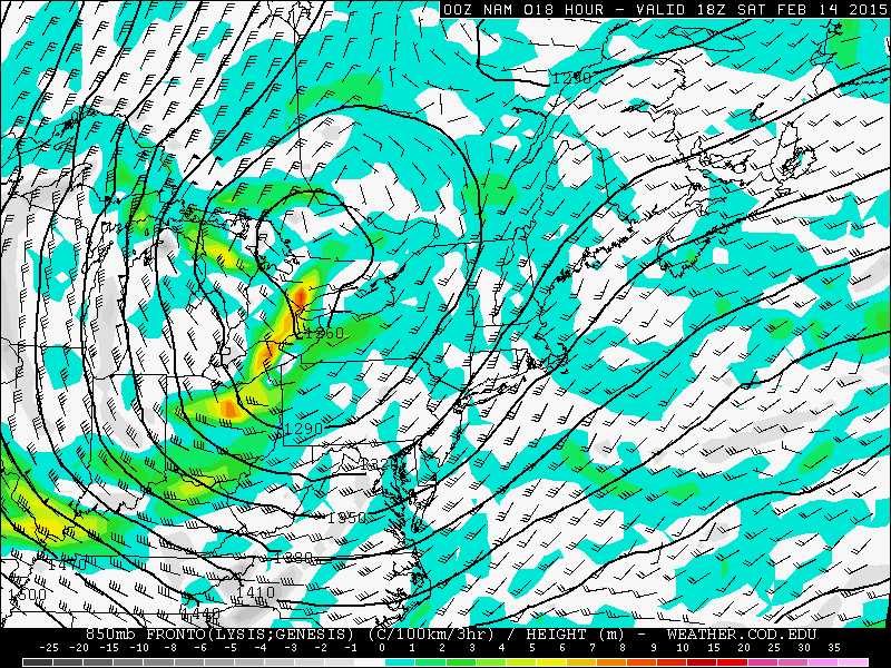
As alluded to above, the frontogenesis values are fairly strong in the low levels along the arctic front as it drops across northern Ohio late Saturday morning and early afternoon. The layer of deep moisture and steep lapse rates along the front on forecast soundings is impressive due to falling mid-level temps and large scale lift acting to steepen lapse rates and raise inversion levels:

BUFKIT 17

Although the model does show a weak inversion limiting the model equilibrium level, the steep lapse rates and good moisture extend well above 10k feet in the atmosphere. If there is enough open water on Lake Erie to modify the airmass at all, equilibrium levels easily climb above 10k feet. This all suggests a heavy burst of snow.

BUFKIT overview

The snow along the arctic front will not only be intense, it will also be very high ratio, with large dendrites likely. Note how the omega (vertical velocity) in the red lines is very strong in the dendrite growth zone (the purple and yellow contours). This suggests that snowflakes will grow very effectively in any snow squalls along the arctic front. With strong omega up to about 17k feet, a flash or two of lightning in any squalls along the front wouldn’t shock me.

Although the snow squalls along the arctic front will be short lived, totals by early afternoon from a combination of the light snow tonight into early Saturday, and the snow showers/likely squalls ahead of and along the arctic front will likely be 2-4”. The high ratio nature of the snow up through this point will improve the likelihood of these totals being realized.

Forecast soundings show 30-40 knot winds along and behind the arctic front in the boundary layer, really just above the ground…cold air advection should help a large portion of that mix down in gusts, causing 30-40MPH wind gusts along/behind the arctic front…strongest near Lake Erie. Due to the high ratio nature of the snow, it will easily blow around. Blowing snow along/behind the arctic front will undoubtedly cause visibility issues and road condition issues.

MODIS

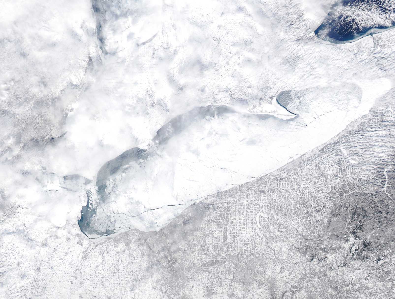
Although there were some cirrus clouds on Friday, we got a good MODIS shot of Lake Erie. There is a large crack in the ice east of the Lake Erie islands towards Lorain (very common), and also along the northern lakeshore. These cracks appear to be slushy, but could open up some with breezy  SW winds late Friday night into early Saturday and strong NWrly winds Saturday afternoon behind the arctic front. There are a few smaller cracks farther east, including a pencil thin but long from all the way up the central and eastern lakeshore that may open some if the southwesterly winds into early Saturday enough.

So, not a lot of moisture to be picked up off of Lake Erie, but definitely some.

BUFKIT 18

Immediately behind the arctic front, instability may briefly decrease for a time as surface temperatures crash a little quicker than the mid-level temps (above)…however, the mid-level temps will quickly recover. There’s still a fairly deep layer of steep lapse rates (that gets deeper again by mid to late afternoon) behind the front and high RH air to above 10K feet, so orographic lift could help ring out snow showers starting very quickly behind the front.

BUFKIT 22

By later afternoon, a very deep layer of steep lapse rates will return and good moisture will remain to above 5k feet. Winds will become very well aligned out of the northwest. This may help any lake effect/orographic lift snow showers increase late Saturday afternoon after perhaps a brief lull behind the front. Snow growth will really diminish by this point as the dendrite growth zone is confined to near the ground (much of the lift is just above the ground). This suggests that even as lake effect snow/orgraphic lift snow increases again later Saturday afternoon that it may not pile up as quickly.

NAM 21 24

The increase in instability later Saturday afternoon will correspond to the vort-max (500mb vorticity on right) moving over Lake Erie and also an increase in mid-level moisture. This all suggests an uptick in lake effect/CAA advection type snow showers…the most concentrated snow will probably be over the higher terrain in the secondary and primary Snowbelts where orographic lift will improve the odds of snow showers developing.

NAM 27

In addition, a surface trough may also drop across the lake Saturday evening, acting as another source of potential increase snow showers downwind of the lake. This surface trough passage does appear to correspond to another increase in low level omega as shown in the NAM overview image above (where I drew a circles and got excited over omega in the DGZ early Saturday afternoon).

BUFKIT 27

Lake effect conditions remain favorable through Saturday evening, so it’s not inconceivable that the vort max passage/mid-level moisture increase and surface trough passage all combine to allow half decent lake effect snow showers to continue through much of Saturday evening, especially in the higher terrain where the NWrly winds will cause good orographic lift. On the sounding above the winds appear to be sheared, but that’s more a product of the trough passing (winds become better aligned again later). The winds veering with height suggests low level convergence along the surface trough…winds over the lake will be closer to the mid-level winds (hence more northerly) due to less friction over the water/ice and slightly warmer temperatures (due to whatever heat flux occurs from the lake to atmosphere)…the warmer temperatures promote mixing of the more northerly winds aloft to the ground. Winds over land will be lighter and NW as opposed to N…convergence near the shore where the two meet.

Later Saturday night, inversion heights and moisture depth decrease quickly, so lake effect should decrease to just flurries after midnight. An exception may be under any Lake Huron band after midnight where light to moderate but very fine snow could continue into early Sunday.

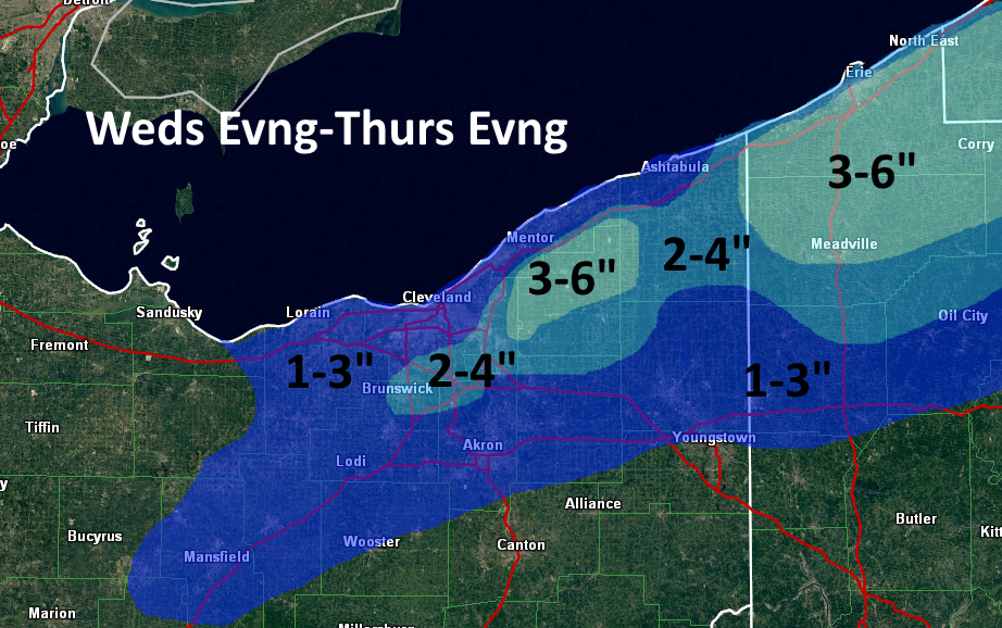
As for snowfall amounts…2-4” synoptic for most. The lake effect is tough. The snowflakes will become very small and hence much lower ratio by late Saturday afternoon, so it will be hard to rack up good accums. The biggest crack in the ice is east of the Lake Erie islands, so to account for this I figured in 1-2” of fine lake effect snow as far west as parts of Lorain/Medina County to push totals to 3-5” here…could see a local 6” total on the west side if a band forms intensely enough before the dendritic growth becomes very low. Farther east, with better terrain and potential Lake Huron moisture, even with the lower ratio of the snow, I have to figure at least another 2-4” of lake effect snow in the higher terrain of the primary Snowbelt. Even though there’s ice on the lake, there’s a lot suggesting decent snow will continue well into Saturday evening, especially in the higher terrain…so I painted in 4-7” here. The only way there’s more is if the Lake Huron connection is better than I think.

As for impacts…winds will gust 30-40MPH behind the arctic front into Saturday evening before gradually decreasing. The snow will become increasingly fine Saturday afternoon and evening, which when combined with the wind could cause significant visibility restrictions into Saturday evening before a gradual improvement occurs. The falling snow and likely extensive blowing snow will cause roads to be very slick from late Saturday morning when the arctic front drops through into Saturday night. Wind gusts and visibilities may arguably push blizzard conditions where lake effect sets up Saturday afternoon and evening, although it may be hard for many spots to actually verify 3 hours straight of 0.25 mile or less visibility and 35MPH wind gusts…but some places will be close.

Posted in Uncategorized | Leave a comment

2/11/15: Tricky Lake Effect Forecast for NE Ohio Wednesday Night-Thursday Night

It won’t be the most snow ever, but it could be enough to move around in parts of Northeastern Ohio Wednesday night into Thursday as a potent shortwave diving through the Great Lakes and upper Ohio Valley sparks some light synoptic snow, with cold/moist air allowing for some lake enhancement to occur.

A multitude of surface cold fronts/troughs will drop south across Lake Erie and northern Ohio between Wednesday evening and Thursday evening, each of which could be the focus for light synoptic snow and some lake enhancement.

Clouds didn’t clear over the central or western basin on Tuesday, although they did clear over the eastern basin and showed some cracks in the ice, but no large openings. There appeared to be a discernable opening in the ice along the SE MI shoreline, but it was hard to tell for sure. Nothing in the central basin between the islands and Lake County was really visible on Tuesday, which is unfortunate.

A cold front will swing through Wednesday evening. Moisture depth is limited with this feature and it won’t be cold enough for lake enhancement, so I expect snows with the front to be limited to an inch or less.

BUFKIT 1

Behind the front, WNW to NW winds will develop and a fairly deep layer of conditionally unstable lapse rates will develop as colder air pours in. The winds could be better aligned, but directional shear doesn’t appear to be more than 30 degrees. Inversions on the Tuesday evening runs of the GFS and NAM rise to around 7k feet behind the cold front overnight Wednesday night with high RH air to about that level. With a WNW to NW wind and moisture pooling ahead of another surface trough beginning to drop across Lake Erie from the north early Thursday, along with some low-level moisture from Lake Michigan in this timeframe, a combination of frictional convergence along the central lakeshore and orographic lift in the higher terrain from eastern Cuyahoga County eastward through Geauga County and also in NW PA could cause light to moderate snow showers to redevelop Wednesday night behind the cold front as colder and more humid air filters in. Synoptic convergence caused by the surface trough dropping down late Wednesday night into Thursday morning should be maximized for a couple or few hours along the Lake Erie shoreline into the Snowbelt. This could all cause another 2-3” of snow overnight Wednesday night into Thursday morning in the higher terrain in eastern Cuyahoga and Geauga Counties and NW PA, with less in the lower terrain…maybe an inch or so with the trough passage.

BUFKIT 2

Behind this trough, there could be a brief disruption in any snow due to increased wind shear. However, by later Thursday morning into Thursday afternoon, winds become pretty well aligned out of the NW with inversion heights of 6-8k feet, and high RH air to above 700mb. This could allow very high ratio orographic lift snow to redevelop for a few hours, especially in eastern Cuyahoga and Geauga and inland NW PA, although with a more true NW wind by this point the higher terrain in southern Cuyahoga/NE Medina/NW Summit could see some orographic lift snow too. With another surface trough dropping through late Thursday afternoon, there could also be enough synoptic lift and moisture for light snow showers to break out again elsewhere and to help any orographic lift snows in the higher terrain. Given how high ratio this snow looks to be (I could see ratios of 30:1 or better for a time late Thursday morning and early Thursday afternoon before it starts getting cold enough to limit dendritic growth) I could see how the higher terrain in eastern Cuyahoga and especially Geauga and NW PA see another 2-3” or snow from this “phase” of the event…with maybe 1-2” in the higher terrain in the secondary Snowbelt and an inch or less elsewhere.

BUFKIT 3

heights lower. With so much ice on Lake Erie, things will probably die down to just flurries pretty quickly Thursday evening outside of a possible Lake Huron connection in Ashtabula County or NW PA, where perhaps another couple inches or so could still fall Thursday evening through early Friday.

This all does add up to potentially 4-6” of snow in the higher terrain of Geauga County and potentially eastern Cuyahoga County…with perhaps a little more in NW PA if a Lake Huron connection can develop…perhaps 2-4” in the higher terrain in the secondary Snowbelt, and about 2” or snow in the rest of the Cleveland metro at lower elevations…spread out over the course of 24-30 hours. Given how dry/high ratio the snow will be, this isn’t a huge impact and probably not enough for an advisory, except for maybe NW PA if the Huron connection does pan out.

models

As for model support…the NMM and ARW, along with the 4km NAM runs both do spit out 0.2-0.35” of QPF in the higher terrain of the Snowbelt. With high ratios, that does fluff out to about the numbers I laid out above, although it isn’t extremely exciting. Given the extensive ice on Lake Erie and only limited upstream lake help in NE Ohio, and a lack of better synoptic lift through the “event”, I don’t see a ton of potential for this to really over-perform and produce a surprise 6-8” in less than 12 hours like the 1/30/15 event did in parts of Geauga County and also eastern Ashtabula County into NW PA. However, I can see how the orographic lift snows produce half inch per hour rates for a few hours at a time given what should be enough moisture due to the synoptic moisture pooling with the troughs, a little upstream lake moisture, and a little moisture from Lake Erie and high ratios. This does support a few inches or so possibly falling over the course of 24 hours or so. If the 12km NAM or any SREF members were spitting out over a quarter inch of QPF, I would potentially get more excited, as that would indicate fairly decent moisture and lift even with the icy lake…and the courser resolution would mean a likely low-ball of the QPF. But as is, the 12km NAM generally spits out 0.1-0.25” of QPF across most of northern OH, with the highest over northern Geauga County…no SREF members Tuesday evening spat out more than 0.25” of QPF in a 24 hour period with the event, which is also a turnoff for overperformance potential.

snow 2-11

Posted in Uncategorized | Leave a comment

2/10/15: Tricky Forecasts Upcoming for NE Ohio as Cold and Some Snow Returns

After a very brief hiatus late last week and into the weekend, winter is returning to Northeastern Ohio this week. Potential below 0 temperatures and lake effect snow will be the highlights over the next several days.

current 500

The current pattern across North America as of Monday evening isn’t a particularly cold one…with a slightly positive PNA and positive AO/NAO…although there is a trough over the SE US getting ready to spark yet another storm off the East Coast. However, the pieces are lining up over the Pacific for a rude arctic intrusion into the central and eastern US later this week and into this weekend.

A strong Aleutian low has developed, which is beginning to help facilitate the development of a ridge along the West Coast all the way up into Alaska (a +PNA and eventually -EPO). At the same time, a very large ridge has developed over eastern Asia (-WPO), and is forcing arctic air to filter into northern Canada. When the +PNA/-EPO become better developed later this week, very cold air will be tapped and will be sent southeastward towards the central and eastern US.

EPS 72

By Thursday, the first of many arctic shots of air will be plunging into the Great Lakes/Ohio Valley/Northeast. This is in response to the +PNA strengthening along the West Coast. Although ridging over western North America doesn’t extend extremely far north at this point, enough cold air is currently present over northern Canada to get some well below average temperatures into parts of the Great Lakes and northeastern US. This first arctic shot will bring our first chance for plowable snow to northern Ohio in what could be a stretch of several chances, and I’ll discuss that more shortly.

EPS 120

By Saturday, the ensembles (ECM ensembles shown above) agree on a classic pattern for delivering cold into the central and eastern US setting up. The +PNA ridge extends all the way into Alaska and can qualify as a –EPO…in addition, a strong –WPO persists. All of this ridging forces a classic cross-polar flow. Cross-polar flows typically mean very cold weather into the northern US, and the cross polar flow modelled for this weekend is one of the best I’ve ever seen over the last several years. Note how the isohypses on the map above run right across the North Pole and then straight down into the Great Lakes. That’s cold stuff, and well below 0 temperatures appear to be a good bet across portions of the Great Lakes and New England.

For perspective, New York City hasn’t recorded a sub-zero reading since early 1994. Some weather weenies have wondered if NYC will ever record a sub-zero temperature again. Although it is still far from a guarantee, the classic nature of the cross polar flow, very deep snowpack over Upstate New York and New England, and trajectory of the coldest air being centered near the longitude of New York City, it is not impossible that that 21 year streak of no below 0 readings is broken for NYC.

The GFS MEX guidance, which is corrected for climatology and typical model biases, is currently projecting a low of 3F for Monday morning at KNYC. MEX is known to be too subdued several days ahead of a highly anomalous temperature event, so the fact that MEX is already giving a temperature close to 0 for NYC is noteworthy. It should also be used as a check…despite the raw GFS showing temperatures easily below 0 for NYC Sunday night (the raw ECM shows a low of around -2F), climatology suggests that this is an extremely rare event. The GFS and Euro have shown NYC getting below 0 in their medium to long range forecasts a few times over the last couple of winters, and none of those forecasts have worked out. So, while it will be interesting to follow, it is still way too early to declare NYC’s long above 0 streak “broken”.

GFSX NYC

Now, onto the Northeastern Ohio talk.

GFS 60

A fairly potent upper level trough will drop through the Great Lakes Wednesday night and Thursday. A low pressure system will track to the north of Northern Ohio. This isn’t a great place for heavy synoptic snows, and I think synoptic snows with this system will generally be an inch or two at most. However, there does appear to be some potential lake effect snow upside as colder air swings in behind a cold front late Wednesday night…if only the damn lake wasn’t frozen! 😉

vis 2

It has been very cloudy lately, however a brief break in the clouds on Saturday allowed us to take a peek at Lake Erie and its ice cover. Satellite showed a large crack in the ice extending from Cleveland and Lorain west to near the Lake Erie islands, and then north to the Canadian shoreline. Although there are clouds obscuring it in this shot, some large cracks were also visible farther east. While not optimal, this is enough open water to get some heat/moisture flux off of Lake Erie when a colder airmass moves in. Considering temperatures were in the 40’s for another 24 hours after this image with southwesterly winds, and considering another shot of above freezing temperatures with decent winds will occur on Wednesday, it is fair to assume that there will be some (albeit still limited) open water on Lake Erie by the time colder air moves in on Thursday, which could allow for some lake effect snow to occur.

Over the years, there have been some moderate lake effect events with an essentially frozen Lake Erie…the most recent one was on January 30th of this year, with parts of Geauga County and inland NW PA seeing over 6” of snow in 12 hours of lake effect off of a mainly frozen lake. I have noticed that a few factors can “help” lake effect occur when the lake is mainly frozen:

  • Deep synoptic moisture
  • Moisture from upstream lakes
  • A source of convergence/lift from a pre-existing surface trough
  • High inversion heights
  • Well aligned winds
  • Frictional convergence along shoreline when winds are nearly parallel to the shore
  • Orographic lift when wind hits terrain inland from the lake at large angles

Most of the above factors are needed for or can help with lake effect off of a non-frozen Lake Erie, but they become more important once the amount of open water becomes greatly diminished.

For Thursday, we could have several of these factors working together when examining the GFS, Euro and NAM.

GFS 63

The GFS, valid 10AM Thursday, shows a sharp surface trough getting ready to cross Lake Erie from north to south. Monday evening’s NAM run had a relatively similar idea.

Euro 66

The Euro, valid at 1PM Thursday, has a similar idea with a trough dropping across Lake Erie. The difference is, the GFS/NAM maintain a more WNW wind Thursday morning ahead of the trough, while the Euro shows a more NW wind ahead of the trough. Winds should go more NW or NNW behind the trough per all models.

This feature is known as an inverted trough. It is not at all uncommon to get an inverted trough hanging back to the west of a low pressure system transferring to the East Coast. These inverted troughs have a surface wind shift, which causes low level convergence and lift, and also allows some moisture to pool along it. All of these factors can contribute to better lake effect snow than what would otherwise occur.

GFS 66 700

When taking an early look at the amount of synoptic moisture involved in the lake effect snow equation for Thursday, the GFS (pictured), NAM and Euro all show a nice lobe of moisture at 700mb rotating through with the inverted trough late Thursday morning into Thursday afternoon. Typically, deep moisture to 700mb or higher in lake effect situations can be a signal for heavy lake effect snow.

BUFKIT 1

BUFKIT 2

When taking a look at a couple of GFS forecast soundings for KCLE from late Thursday morning (ahead of the surface trough passage) and early Thursday afternoon (near the surface trough passage), you can see high RH air extending to near or higher than 10k feet on both soundings, with inversion heights climbing to over 10k feet around the time of the trough passage. The GFS also shows a good amount of low level omega (white line) as the trough passes. Lake effect conditions behind the trough remain decent into Thursday evening before inversion heights really begin to lower and the atmosphere dries out.

The NAM soundings are fairly similar. Although I can’t look at the Euro in BUFKIT, I’d imagine its instability and moisture parameters are similar…although the winds on the Euro go from NW ahead of the trough to NNW behind it…instead of WNW ahead of the trough to NW behind it like the GFS/NAM show. With a NW or NNW wind behind the trough, any Lake Michigan moisture would likely go west of Cleveland, while any Lake Huron moisture would stay in Ashtabula County or NW PA.

At this point, what it boils down to for Thursday’s lake effect snow potential:

Ice on Lake Erie will likely make it hard to see the instability numbers BUFKIT is spitting out (I can’t set lake water temperatures any lower than 32F in the program). However, some openings in the ice per satellite imagery, increased convergence and moisture with a trough passage late Thursday morning or early Thursday afternoon, and high inversion heights do suggest that some moderate lake effect snow may occur. The GFS/NAM scenario would likely result in the potential for somewhat higher totals than the Euro, as a W or WNW wind ahead of the trough would maximize frictional convergence along the central lakeshore and interact with any modification of the airmass over Lake Erie by any open waters by potentially focusing a band of more organized snowfall near the central lakeshore and into the primary NE OH and NW PA Snowbelt ahead of the trough passage, with weaker multi-bands that favor the higher terrain taking over in the NW flow behind the trough. Although the Euro would also suggest an increase in snow with the trough passage, it wouldn’t suggest a decent band forming ahead of the trough, potentially keep accumulations lighter. Any Lake Huron connection will be well east of Cleveland.

On the balance, with the 12km NAM/SREF members showing 0.25” of QPF or less with this lake effect event, I think amounts will only be light to locally moderate. If the GFS/NAM wind forecast pans out, there could be a nice burst for a few hours along/ahead of the trough before more disorganized multi-bands take over, which could allow for a few areas in the higher terrain east of Cleveland and in NW PA to see 4” of snow or more, with less elsewhere. The Euro would seem like a widespread 1-4” snow event with less potential for heavier amounts, except for perhaps Ashtabula County east into NW PA where some Lake Huron moisture would likely end up and enhance snowfall some.

Not the most exciting, but I enjoy the challenge of trying to pin down lake effect with a frozen lake.

More Snow Friday Night-Sunday

GFS 117

The arctic shot of air discussed to begin the article will move into Ohio on Saturday. Aloft, an extremely potent upper level trough (that most models have closed off at 500mb) will move over the Great Lakes…which is typically a signal for heavy lake effect snow. At the surface, a low pressure will likely drop through the Great Lakes (possibly over Lake Erie) Friday night into Saturday before this system also transfers to the East Coast and then intensifies.

Because of how potent the upper level trough diving into the Great Lakes will be, I’d have to think there will be some potential for accumulating synoptic snows, on the order of a couple inches or so, across northern Ohio as the low pressure system drops down…despite extremely low PWAT air. Then we have to try to forecast more lake effect snow with an icy Lake Erie.

I don’t want to get as specific so far out, but with a very deep trough moving overhead, high RH air should extend well above the 700mb threshold Saturday into Saturday night, with very high inversion heights. Models currently agree on winds going NNW or N at some point on Saturday, which favors good orographic lift in the secondary Snowbelt south of Cleveland and the primary Snowbelt east of Cleveland, and also favors Lake Huron moisture making it as far west as the Cleveland metro. 500mb temps are progged by the GFS and Euro to dip below -40C by Saturday evening, which if it held would be remarkably cold.

Although ice on Lake Erie will limit instability a fair amount, the high low to mid-level RH air, very high inversions, orographic lift and help from Lake Huron could combine to cause event storm totals in excess of 6” (lake effect and synoptic) from late Friday night through Sunday morning in the higher terrain of NE Ohio and NW PA. One concern is the extremely cold temperatures stunting snow growth and limiting snow:liquid ratios by Saturday afternoon, which could also keep totals from getting out of control. However, the setup appears interesting, despite the icy lake…more interesting than Thursday’s setup.

There could be some synoptic snows next week in the region as some energy in the sub-tropical jet moves out of the southwest US…I will try to discuss that more later.

Posted in Uncategorized | Leave a comment

1/29/15: Potential Wide-Reaching Winter Storm Saturday-Monday

This won’t be my longest post because I need sleep. BUT, as I posted last Friday morning, I was intrigued in the potential for a winter storm around the turn of the month. Due to the East Coast blizzard stealing the focus for a few days, I haven’t updated on that threat since. But it’s still there.

current 500

A current look at the 500mb (middle of the atmosphere) weather pattern shows a shortwave ridge moving east across the central US bringing a brief moderation in temperatures to that region. This map currently isn’t a good one for a major snow across the central or eastern US, but features that will make the pattern more conducive for snow are already on the map (I love it when things are already on the map!)

-A polar vortex remains anchored over northeastern Canada. This polar vortex will be pushed south towards Hudson Bay this weekend due to the AO turning negative. This will help ensure that cold air is in place across the north-central and northeastern US this weekend, and limit how far north any storms can go.

-A fairly potent clipper type system circled over the central US will help re-enforce the trough off the East Coast. This will spawn a fairly strong storm over the Canadian Maritimes Friday into Saturday, which will help the NW Atlantic thumb ridge extend north towards Greenland and become a –NAO block this weekend.

-A vort-max will break away from a large upper level low pressure sitting south of Alaska by Friday and become a shortwave that will move into British Columbia and dive towards the Rockies.

-Moisture with a sub-tropical jet cut-off low off of Baja of California will attempt to move east this weekend ahead of the shortwave diving into the Rockies, and potentially get tangled up with it and help cause a storm.

-Ridging will build up the west coast of the US and British Columbia from the south through this week and will also really build into Alaska from the west. This ridging, combined with the polar vortex shifting south by this weekend suggest the shortwave diving into the Rockies that may eventually spawn our storm could dig more aggressively than some of our current models.

You can see how the strength/track of the northern shortwave diving down influences if any of the cut-off low over the SW US ejects east or not by looking at our two most recent runs of the GFS model:

GFS comparo

Tonight’s 0z GFS run on the left was a little bit more pronounced with the shortwave diving into MT/WY Saturday evening. This allows more vorticity (color fill) and moisture (not on these maps) with the cut-off low to eject farther northeast. Wednesday evening’s 18z GFS run on the right was flatter with the shortwave diving into the upper Plains, and note how the cut-off low remains larger and less vorticity advects out into the Plains. Here’s the difference that made in snowfall output:

GFS snow comparo

The 0z GFS has a much larger swath of moderate to in some cases heavy snow from Kansas clear east to the Mid Atlantic, with a low tracking across the Tennessee Valley. The 18z GFS has a swath of very light snow from the Ozarks east through the lower Ohio Valley and Mid Atlantic with no real surface low. Note that the snow over New England is from the storm this Friday in that region that I’m not really discussing in this post.

So obviously, a small change in the shortwave diving into the Rockies on Saturday and in how much of the SW US cut-off ejects east made a huge snowfall difference.

For reference, this evening’s Canadian model run ejected a little bit more of the cut-off and had a swath of even heavier snow a little farther north, with a surface low track along the Ohio River to near Pittsburgh, before re-developing off of the coast near DC:

CMC snow

This evening’s Euro run ejected a little less of the energy and was noticeably weaker with the shortwave diving into the Rockies on Saturday and had a swath of 2-5” type snows from Missouri points east across southern IL/IN/OH, northern KY and into the lower Mid-Atlantic.

What do the ensembles say?

Everytime our main forecast models are run, the model is re-run 20-50 times (depending on the model) with different perturbations to come up with a reasonable range of forecast outcomes.

When looking at a plot of the 1008mb sea-level pressure line of each GFS ensemble member, we see that about half of the ensemble members (maybe one or two less) have a low pressure deeper than 1008mb Sunday evening. Most of them track it on either side of the Ohio River (none north of approximately I-80 in Ohio):

GEFS 96 spag

This is a couple members showing a stronger low pressure and farther north track than this evening’s 18z run of the GFS ensembles:

GEFS 102 spag

A slight trend for a stronger storm has occurred in the GFS ensembles this evening.

The Wednesday afternoon Euro ensemble mean has a low pressure system much farther southeast by Monday morning:

EPS 96

It should be noted that the 0z Euro did bump north some from its 12z run…it’s possible its ensembles bump north too, but they aren’t out yet.

The GFS ensembles this evening indicate a general trend to a stronger storm being possible. The pattern supports this in my opinion:

EPS 96

The reason I believe a stronger storm is possible is mainly due to the large upper level ridge of high pressure on the west coast combining with the polar vortex over Hudson Bay causing a high-amplitude north-northwest flow over Canada into the Rockies. This could conceivably force the shortwave diving into the Rockies on Saturday (denoted by the purple lines) to dive in more aggressively and farther southwest, which would allow it to help kick-out the cutoff low over the SW US/towards Baja, and help contribute to a bigger storm.

What the storm does when it gets to the east coast is highly dependent on how strong it gets over the Great Lakes/Ohio Valley. A stronger storm farther west would likely track north of the Ohio River, and would probably be bad news for snow south of the Mason-Dixon line east of the Appalachians. A weaker storm may work for areas farther south but would have less snow overall.

EPS 120

If the storm doesn’t cut too far north while west of the Appalachians, the pattern is favorable for decent snows in New England and the Mid Atlantic (12z Wednesday Euro ensembles shown above for Monday morning). This is due to a –NAO (reds extending towards Greenland) and low height anomalies over Newfoundland acting as a 50/50 low…features that were missing when the blizzard ended up whiffing the Mid Atlantic Monday and Tuesday of this week.

Overall, due to the high amplitude ridging over the western portions of North America and polar vortex over Hudson Bay, I’m leaning towards the northern branch shortwave that possibly helps kick out a part of the SW US cutoff low and cause a storm being a bit stronger than currently modeled. This argues for a stronger storm. However, due to the –NAO, PV location and pseudo 50/50 low I’m not favoring a storm that cuts hard into the Great Lakes. Instead, a storm that runs along either side of the Ohio River before reforming off of the Mid Atlantic Coast is my favored solution at this time…with a swath of moderate to heavy snow north of that swath from the central Plains points east.

There are some caveats here…the main one being that the shortwave that will dive into the Rockies and cause all this is still a part of a large upper low in the Northern Pacific ocean, and won’t move over the North American radiosonde network until Friday night or early Saturday. This suggests wild model swings are possible for another couple of days, and also means that it is hard to be confident in one solution…although I am certainly leaning towards one at this time.

WHAT COULD GO WRONG (in order from most to least likely):

  • Shortwave diving into Rockies is flatter, cutoff doesn’t eject. Just a swath of light snow farther south instead of a bigger storm.
  • Shortwave diving into the Rockies is much stronger than expected, entire cut-off ejects, larger and stronger storm would cut into the Great Lakes with a potential transfer to the New England coast. May mean heavier snow amounts but they’d be farther north…from say St. Louis to Chicago to Detroit to Toronto and perhaps a bit farther northwest.
  • NAO and 50/50 combo don’t work out…storm would be more prone to cut either into the Great Lakes (even if weaker in this case) or at least run inland from the East Coast.
  • The models find a new way to f*** everything up. We’ve seen a lot of that this winter.

So, lots of stuff to watch. Will call forecast confidence low due to the large model spread and inherently unpredictable nature of SW US cut-offs and shortwaves that are still a part of a N. Pacific gyre. Will try to update Friday but no guarantees…busy week for me.

Posted in Uncategorized | Leave a comment

1/27/15: Some Reflection on the Ongoing BUST for Philadelphia and NYC

BUST! Although locations from Long Island into much of southeastern New England are seeing or will soon see a crippling blizzard into the day Tuesday, the corridor from eastern Pennsylvania –including Philadelphia– to New York City will not see anywhere near the projected snowfall. After putting hours and hours into forecasting this storm late last week, this weekend and even on Monday, it is extremely disappointing to see the forecast go so badly for such a large area.

I owe it to you…and myself…to determine where the forecast went wrong. First a little bit of background information: This type of Nor’ Easter is called a “Miller B” storm. These types of storms involve a clipper system that drops through the Midwest and Great Lakes or Ohio Valley and then re-develops into a Nor’ Easter off of the East Coast. These storms typically drop their heaviest snow on New England. New York City is far enough northeast to get in on the “action” from Miller B’s when the pattern is right (if they move off the coast far enough south). Philadelphia is much trickier…they have seen over a foot of snow from Miller B’s before, but have also been completely screwed out of snow by Miller B’s, even when significant amounts are predicted the day of the storm…much like what occurred this go-around. I mentioned my concerns about Philadelphia seeing heavy snow multiple times and did keep the highest totals northeast of Philly, despite what the Euro and NAM showed at times, but was still WAY too high there. If the upper level portion of the storm developed like the Euro and NAM showed, Philly would’ve gotten heavy snow, but that didn’t occur, which I’ll explain below.

Typically, the Mid-Atlantic needs a -AO and -NAO to get a major snow storm. New England can get by with neutral or even positive values in the right setup. The NAO and AO were both close to neutral for this storm. Last week I was worried that this storm wouldn’t be major for anyone due to those lackluster indices, and mentioned in my long discussion blog post leading up to this storm that the AO and NAO weren’t optimal, which gave me some pause about the Mid Atlantic snowfall projections. However, a piece of the “polar vortex” was expected to be in a favorable position…near 50N, 50W (known as a 50/50 low) for a Mid Atlantic snow storm, which gave me enough justification, in my mind, to forecast heavy snows for parts of the eastern Mid Atlantic. This is where the forecast went wrong.

Euro vs actual

After comparing last night’s extremely snowy Euro run to the actual observations this evening, it appears as though the polar vortex was a little farther northeast than expected. The polar vortex probably moved away a little bit due to a lack of a -NAO. This gave our storm more room to swing out to the northeast before stalling out and really intensifying, which pulled the heaviest snows away from the Mid Atlantic and even New York City. The Euro absolutely nailed the location of the “shortwave” moving off of the East Coast Monday evening, which is why many, including myself, were reluctant to pull the heavy snows east of the Mid Atlantic.

In reflection…snowfall climatology in the Mid Atlantic suggests a favorable NAO and especially AO are needed for significant storms…with just a few exceptions. Unless the models are in unanimous agreement (which they weren’t for this storm) that a storm will buck this strong trend, it is not wise to forecast heavy snows in the Mid Atlantic from Miller B low pressures especially. This is the Euro’s worst bust with a Nor’ Easter in quite some time…it is normally extremely solid with Nor’ Easter forecasts…but this goes to show that not even “the king” isn’t infallible. Miller B’s will continue to give Mid Atlantic forecasters fits due to their known boom or bust nature in the region. Typically with Miller B’s, unless the AO and NAO are strongly negative, you have to be farther north to get the heaviest snows.

Posted in Uncategorized | Leave a comment

Updated Snowfall Estimates for Nor’ Easter/Blizzard

UPDATED SNOWFALL ESTIMATES:

snow 1-27 blizzard final

I have updated our snowfall estimates for the impending Nor’ Easter/blizzard for the East Coast. Forecast totals include:
DC: 1-3″
Baltimore: 3-6″
Philadelphia: 12-18″
NYC: 18-30″+ (blizzard)
Boston: 18-30″+ (blizzard)

Coastal flooding is also a concern from New Jersey northward into New England due to strong on-shore winds. Damaging wind gusts are likely on Cape Cod, Nantucket and Martha’s Vineyard.

As discussed this afternoon, the European model supports more snow farther west, while the GFS and NAM are much lighter farther southwest (for example, both only show light to moderate amounts for Philadelphia, and even the new NAM is less than a foot for NYC). After doing a careful review, the clipper that will spawn our Nor’ Easter is behaving very close to how the Euro expected as it moves across the Ohio/Tennessee Valleys this evening. This afternoon’s NAM/GFS models were already a little to far northeast with the clipper. This suggests the Euro’s heavier snows farther southwest are certainly possible. In addition, the GFS and NAM appear to be suffering from “convective feedback”…that means that they allow thunderstorms to incorrectly influence the low pressure’s track and intensity Monday night into Tuesday morning. The thunderstorms are shown to be northeast of the developing Nor’ Easter, meaning the thunderstorms on the NAM/GFS may be artificially pulling the low to the northeast. The upper level evolution on the NAM/GFS of the storm, while a little quicker with everything than the Euro, don’t appear to match-up with how quickly they move the low northeast Monday night.

I still trimmed amounts a little bit over parts of SE Pennsylvania, extreme eastern Virginia and the Delmarva. This is because “Miller B” low pressure systems (clippers that re-develop as Nor’ Easters) tend to “screw” the Mid Atlantic. They often feature a very sharp southwestern cut off to the snow, with Philadelphia often in the cross hairs of this sharp cut-off of the heavy snow. Although the Euro’s forecast appears to be reasonably on track, the areas discussed above often see less snow than modeled in these Miller B situations. I believe the Euro’s snow forecast is close to reality but did take a little bit off of the southwestern edge.

Posted in Uncategorized | Leave a comment

Sunday PM Update on Upcoming East Coast Blizzard

GFS and Canadian shift east slightly; Euro holds firm:

Euro snow

GFS snow

Canadian snow

Good afternoon. We are seeing conflicting signals among our three main computer models for the upcoming East Coast snowstorm Monday through Tuesday. The GFS and Canadian have shifted the storm –and heaviest snow– east, with Boston still getting crushed on both models and NYC getting a little less. Philly would see only light to moderate snow per the GFS and Canadian. The European model has held course and strongly supports our forecast from yesterday of the heaviest snows extending from northern New Jersey to Boston, with locations as far south and west as eastern Pennsylvania, Philly and the Delmarva getting in on heavy snows.

When diving a little deeper, the GFS and Canadian appear to be a little “flatter” with the clipper system that will move off the East Coast on Monday and re-develop into a strong Nor’ Easter. This causes the low pressure to strengthen a little farther east, pulling the snow a bit east with it. The Euro has been almost exactly the same with this energy for 3 straight runs now and develops Nor’ Easter farther west. The Euro’s consistency, and support from its ensembles, is hard to ignore.

Euro vs actual

When looking a little deeper, the Euro’s projection for where our clipper would be this morning on its run yesterday afternoon was extremely close to reality. The clipper (over the Midwest, labeled with a line) is almost EXACTLY as strong as the Euro expected and where the Euro expected…the polar vortex over SE Canada (labeled PV) is almost EXACTLY as strong as the Euro expected…and the strong ridging over the western US is essentially EXACTLY as strong as and in the same spot as where the Euro expected.

Considering that nothing appears to have changed from yesterday and the Euro is holding steady with its farther west solution, I am not inclined to change my forecast…which includes 1-3″ for DC, 3-6″ for Baltimore, 12-18″ for Philly, and 18-30″ for NYC and Boston with blizzard conditions in the latter two. Coastal flooding is also a concern along the coastline due to strong on-shore winds. The only minor change may be to diminish amounts over the Delmarva a little bit. For the full meteorology behind the forecast, please see the blog entry from last night.

Euro images normally can’t be posted to social media due to copyright issues…however, the Euro snow map I posted is from another very popular page, and was already freely out there because of that.

Posted in Uncategorized | Leave a comment

1/24/15: Major, Potentially Crippling Storm Looking Increasingly Likely for Parts of East Coast

Please click on images for full size.

A strong clipper system (due to its origins, is known as a “Manitoba Mauler”) will move through the Ohio and Tennessee Valleys on Sunday, producing snows. The clipper will move off the Carolina coastline Monday morning, and a Nor’Easter will develop from this clipper and track north-northeast up the East Coast. This Nor’Easter appears to have the potential to produce a significant amount of snow, high winds and blizzard conditions.

Here is my first attempt at guestimating snowfall amounts for this storm. Barring massive changes, amounts of over 2 feet in the hardest hit areas seem likely…probably in southeastern New England but possibly as far southwest as New Jersey. There will be a sharp southwestern cut off to the snow…as of now, for reasons I present in the text below, I believe that Philadelphia will get in on the heavier snows, while DC and Baltimore are in that area that may or may not see heavy snows, depending on exactly where our storm tracks and how quickly it intensifies. There may be changes to these estimates and I will try to update again tomorrow. Please note, this map does not include snows that will fall from the “clipper” Sunday and Sunday night. The clipper may drop a swath of moderate snow from Indiana and through Ohio and into Pennsylvania. That is NOT included on this map:

1-27 blizzard 1

Detailed Discussion:

HPC tracks

The track of a “clipper” system through the Midwest and Ohio Valleys has shifted drastically over the last 2 days, with the clipper now expected to drop into the Tennessee Valley before rounding the corner and tracking up the East Coast with heavy snow for parts of the region. The clipper was initially expected to take a much “flatter” track off the East Coast and only drop moderate snows, but that has changed.

GFS old vs new

You can see how our models are now handling the clipper that will lead to this major East Coast snowstorm differently now (right) vs Friday morning (left). The clipper drops farther southwest and is noticeably stronger. This allows the clipper to “round the corner” farther west and come up the East Coast. You can see why the farther south solution for the clipper has really opened the door up to a potentially large East Coast snowstorm when looking at the large scale weather pattern:

EPS 48

The Atlantic pattern initially looked like it wouldn’t be extremely favorable for a significant or major East Coast snowstorm when this clipper moved off shore. It was assumed the clipper wouldn’t take on a negative tilt until it moved off the coast, and without a classic –NAO block over Greenland, it was expected that snow amounts would be more moderate for parts of the Mid Atlantic.

NOW, the clipper dives far enough south and is strong enough that it takes on a negative tilt while moving over the Appalachians. This is considerably farther west than expected through Friday, and is in a great spot for a major East Coast storm. The Atlantic pattern isn’t optimal, BUT, the polar vortex (PV) is in a good enough location that it acts as a pseudo “50/50 low” and helps lock in cold over the Northeast US…something that was lacking with the Friday night Nor’Easter, which caused the big I-95 cities south of NYC to see a considerable period of rain instead of snow. The negatively tilted trough is important because it signifies a strengthening area of low pressure at the surface, often causes the storm to slow down and often causes the storm to hook a bit to the “left” in terms of its track. A neutrally tilted trough as expected as late as Friday on the East Coast would NOT have allowed this big storm to occur close enough to the coast for heavy snow. Well, that has changed.

The CIPS analog tool allows you to find out what past upper-level weather patterns similar to what is modelled in the coming days have produced in the past. I will show you the analog guidance based on two timeframes…one Monday evening, just as the clipper is getting ready to move off the coast, and one Tuesday morning, as the major Nor’Easter is expected to reach peak intensity:

CIPS 1

By this point, we have a negatively tilted shortwave along the East Coast, although rapid deepening hasn’t begun yet. A negatively tilted shortwave in this position is already a good sign for a major East Coast storm…out of 15 top CIPS analogs for the above weather pattern, the mean snowfall for the East Coast was light to moderate, with heavy amounts for New England:

CIPS 2

If you move the analogs ahead 12 hours to when our models expect the storm to really “bomb out” off of the Mid-Atlantic and New England coasts, the mean snowfall for the top 15 analogs to that scenario is significant for much of the eastern Mid-Atlantic and New England:

CIPS 3

So, we have some historical precedence for heavy snows when a shortwave takes on a negative tilt on the East Coast and causes a rapidly intensifying low pressure as our models are expecting Monday into Tuesday.

The question is, are the models right in their depiction?

GFS 54

When looking at the energy in the mid-level of the atmosphere Monday evening, you can see the factors that will help contribute to a solution similar to what today’s models show…a significant East Coast snowstorm. Our clipper, labeled with an L, has taken on such a strong negative tilt that the upper level flow (the black lines and wind barbs) is south-north…which suggests any low pressure would track up the coast instead of out to sea. In addition, a second “shortwave” (labeled X) is dropping into the larger trough over the East Coast. This system drops in to the west and south of our clipper/developing East Coast low and re-enforces the negative tilt of the trough…it also helps tug the East Coast low to the southwest, which contributes to a slow movement of the low pressure as it moves up the coast and strengthens.

GFS 54 66

All of the things discussed above…the negative tilted trough, the slow movement of the storm…contribute to a better environment for a quickly deepening low pressure system off the East Coast. In the above two-panel image of the GFS model valid Monday evening on the left and Tuesday morning on the right, you can see high-speed air in a “jet streak” in the upper levels of the atmosphere rushing air away from our strengthening low pressure system…especially by Tuesday morning. If the trough doesn’t go negatively tilted, this evacuation of air, called “upper level divergence,” is not nearly as effective, and the storm strengthens slower. Again, the clipper diving farther south and becoming stronger than previously expected is absolutely key to this scenario. However, as is, all systems appear to be go for a strengthening low pressure system off the East Coast with heavy snows for the big I-95 cities, especially from New Jersey points north, due to the polar vortex acting as a pseudo 50/50 low and locking cold air in place over the Northeast US.

The big question becomes: Where will it snow and how much?

HPC winter 3

Currently, the Weather Prediction Center has a low risk of 4”+ snow from the Delmarva Peninsula points north…with high risks for 8” and 12”+ of snow over parts of southeastern New England. I believe these probabilities are extremely conservative on the southwestern side of things.

Don’t get me wrong: clippers that re-develop along the coast often have a very sharp southwestern cut-off to the snow, and often screw portions of the Mid Atlantic in terms of snow…however, I believe this storm will re-develop far enough west and track far enough west for more snow farther west than these maps imply.

Between our two “best” models this afternoon, the European model showed very heavy snow much farther west than the WPC expects…while the WPC favored a solution closer to the GFS. I normally can’t post Euro model snow maps due to copyright issues, however, this snow map has been floating around on social media all afternoon, so I figured I’ll pluck it down off of Facebook and put it in here:

Euro snow

The GFS model on the other hand was a little bit faster with the storm and developed it a little slower, resulting in considerably less snow outside of eastern New England:

GFS snow 12z

Out of the rest of our main models this afternoon, the Canadian and UKMET were both also much closer to the GFS.

HOWEVER, the European ensembles came in resounding support of the operational Euro, with a slower storm track and quicker intensification, and hence more snow farther southwest:

ECM and ENS

Note how by Tuesday morning the operational Euro and its 50 member ensemble are both very similar in placement of the low pressure…the operational is maybe 30 miles west of the ensemble mean. Also note how the ensemble mean has a central pressure of 983MB, as deep as the op…considering this is a 50 member mean and that there is some variation in the members, this likely means that many members actually have a stronger low. Note how the color fill represents a closed upper level low over the Mid-Atlantic coast in a very similar position on the operational and ensemble forecasts. When the Euro and its ensembles agree this well in an East Coast winter storm situation, you need to listen. The Euro earned its nick names over the years (such as “the King” and “The Doctor”) by nailing East Coast snow storms while the GFS struggled until the last minute.

Not only is this ensemble support a great sign for those who want more snow in the Mid Atlantic, but the clipper that will eventually move off the East Coast Monday morning and cause all of this continuing to trend stronger and farther southwest, along with it taking on a strong negative tilt as it gets to the East Coast, and the shortwave diving into the trough of the storm on Monday night west of our deepening Nor’Easter argue strongly for the Nor’Easter that develops to move slower and become strong faster. This all sounds fine and dandy…but then, this evening’s next GFS run came in and trended STRONGLY towards the Euro:

GFS 18z

More snow and much farther west with it. In addition, although it’s not quite as far southwest as the Euro yet, note how the GFS now also has a closed off mid-level low along the Mid-Atlantic coast Tuesday morning:

GFS 500 66

That’s a pretty good jump towards the Euro in one run of the GFS. In addition, this evening’s run of the GFS ensembles also show decent snows back through New Jersey and down towards the Delmarva:

GEFS 78

Not only does the GFS seem eager to jump into bed with the Euro’s solution, likely due to the strong negative tilt of the trough when it hits the East Coast, but one of the closest analogs from a pattern perspective that has been brought up today for this storm is the Lindsay Day Storm in February of 1969:

Lindsay 500

This setup also lacked a strong –NAO and 50/50 low…move of a thumb ridge in the northeastern Atlantic…however, the polar vortex was in very similar position east of Hudson Bay as to what is expected for the upcoming storm, with ridging over the western and into the central US. It is uncommon to get big East Coast storms without a good –AO and –NAO, but this setup managed to pull it off. Also note where the shortwave is, moving off the VA/NC coast and taking on a negative tilt. If anything, the shortwave for the Lindsay storm is a little weaker and farther northeast than the one that will move off the southeast coast on Monday, and a bit weaker. This suggests that our upcoming storm could produce heavy snows even farther southwest than the Lindsay Day storm:

Lindsay snow

The Lindsay Day snowstorm produced heavy snows right up to Philadelphia and into extreme eastern PA, with a very sharp cutoff any farther southwest. If our storm comes in stronger than the Lindsay storm and a tad farther southwest, this would likely mean the typical Miller B “screw zone” is even west of Philadelphia…meaning Philly gets in on good snows.

So, I am favoring the heaviest amounts from near NYC up through eastern New England, with heavy snow as far southwest as Philadelphia and the Delmarva before quickly tapering to the southeast. IF the clipper that will cause all this comes in any farther southwest, more snow may occur farther southwest too. The models all generally track this Nor’Easter very close to the 40/70 benchmark…storms that track near or over 40N, 70W take an ideal track for significant amounts of snow in the Mid Atlantic and New England.

As for how much snow will fall, the GFS and Euro both agree on over 2 feet falling in the hardest hit areas. This will be a strong and slow moving Nor’Easter, so excessive amounts aren’t impossible. Once the upper level low with the Nor’Easter “closes off” over the Mid Atlantic, it will only slow drift to the northeast past New England per the Euro and new GFS. This slow movement favors amounts of 2 feet or more where the heaviest snow occurs. In addition, this afternoon’s Euro run actually showed the surface low with this Nor’Easter executing a cyclonic loop off of the New England Coast. Strong Nor’Easters that execute such loops close to the coast also often tend to produce at least 2 feet of snow in the hardest hit locations. Given all of these factors pointing to very heavy snow, I expect at least 2 feet in the hardest hit areas…somewhere in the corridor from northern New Jersey into eastern New England.

This Nor’Easter will be very strong, with wind gusts in excess of 60MPH likely near the coast. Blizzard conditions are a very distinct possibility for both Boston and New York City barring major changes.

Posted in Storm Forecasts | Leave a comment

1/24/15: BEHIND THE FORECAST: Sunday’s Snow (Ohio)

WV

A potent piece of energy in the jet stream has moved into British Columbia Friday evening. This energy will dive southeast into the High Plains and move southeast through the Ohio Valley as a “clipper” type system, bringing a swath of locally moderate to heavy snow with it. This swath of snow will move across Ohio, and this post will break down some of the forecast challenges associated with the snow forecast for this system as it moves through Ohio Sunday and Sunday night (the snowfall forecast map is at the bottom, for those curious).

HPC low tracks

There is a pretty decent clustering in our models on a low track Sunday evening near the Ohio River. As can be seen, there is some variation in this track, which will affect where exactly the swath of snow will go across Ohio. This track is generally too far north for snow in southern Ohio, but can be good for central and northern Ohio depending on how exactly large the area of snow associated with the system is.

NAM and GFS

A look at two of our main forecast computer models show two different snowfall ideas for Sunday and Sunday evening across the Buckeye State. The GFS model on the left is a little farther north with the swath of snow, but shows lighter amounts, generally 3-5” or so in its swath of heaviest snows. The GFS would get 2-3” of snow into Cleveland and 3-5” into Akron, with Columbus getting about 2” on the southern edge. The NAM model is a bit farther south with the swath of heavier snow and shows heavier amounts, in some areas as high as 6-7”. The NAM is also less generous with snow amounts on the northern edge and shows Cleveland struggling to see 1” of snow, with Akron getting 1-2”. The NAM shows an extremely sharp decrease in snow right across Columbus.

The question is, which model is right?

One way to determine this is to look at ensembles of these models…essentially, the model is run 20 times with different perturbations, to give you a possible range of solutions. In this case, the GFS ensembles are pretty supportive of the operational model:

GEFS

The axis of heavier snows run generally along and north of I-70, with an inch or two getting into Cleveland.

SREF snow

Ironically, on the short range ensemble forecast system (essentially the NAM ensembles), their mean snowfall forecast is closer to the GFS in terms of placement…with a sharp cutoff south of I-70, and with amounts of 2” or so getting into Cleveland and northeastern Ohio. It should be noted that the snow along the Ohio River in southeast Ohio east into Pennsylvania is falling Friday night into Saturday and is separate from this system.

So, the evidence would seem to support the GFS and its slightly farther north swath of snow, right? Ehh, not really. Our computer models have been gradually shifting the swath of heaviest snows south in their last day’s worth of runs, and it’s possible a gradual south trend continues for the next couple of runs (they’ll eventually settle on a solution and hold steady with it). You can see this slow but steady south trend with every run of the GFS between Thursday evening and Friday evening…the runs start Thursday evening on the left, and occur every 6 hours, until Friday evening’s run of the model on the right:

GFS past 5

The NAM model, along with other models, has also seen a similar trend south. The reason for this trend is evident when looking at the large scale weather pattern across the continent this weekend:

EPS 48

A large ridge of high pressure (all of the red) along the West Coast and a large trough (all of the blue) in eastern Canada into the Northeast US will cause our clipper to dive pretty far to the south. The orientation of the clipper on the above image suggests a continued southeast track into the Ohio Valley before the clipper will turn more easterly by the time it hits the east coast. Due to how far southwest the clipper is diving into the Midwest, and the large trough over the eastern portions of the continent, the more south trend makes sense. I don’t expect the swath of snow to trend any farther north in Ohio, and in fact the south trend may continue. The reason for this is the south trend really commenced as the energy that will turn into our clipper moved over North America, where weather balloons were able to provide a more accurate representation of the intensity of the clipper for our models. When the models had this better data they trended south. This clipper still wasn’t fully “sampled” for the Friday evening model runs (full sampling will occur Saturday morning), so some continued tweaks to the track of the low and location of the heavier snows may occur…although I think we’re zeroing in on the final solution with tonight’s runs. If anything, a slight south adjustment may occur with the models Saturday morning, but not a ton more.

Due to the recent southern adjustment in our computer models and the chance for a slight further bump south, I don’t expect much snow for far northern Ohio…along the Lake Erie shoreline and east of Cleveland…maybe an inch or two…with a gradual increase farther south. The heaviest snows will probably fall just north of I-70, however whether this heavy snow gets as far south as Columbus, and exactly how much snow falls in this corridor are still somewhat uncertain.

NAM 850

When looking at the track of the low associated with the clipper in the mid-levels of the atmosphere, the NAM takes it right along I-70 (above image). The GFS is about 30 miles south of this track. This mid-level low track is important, because with clipper systems, it is very uncommon to get much snowfall south of the mid-level low track. The NAM track would suggest the best snows staying just north of I-70 and Columbus, while the GFS track would suggest the snow possibly coming a bit farther south, probably along I-70 and into Columbus.

NAM GFS 2m

Another factor to consider will be temperatures in the lower levels of the atmosphere (above). The airmass ahead of this clipper won’t be particularly cold, and with a southerly wind flow ahead of the system Sunday morning, air temperatures could easily rise well above freezing on Sunday in parts of southern and central Ohio, which would cause the precipitation to fall as rain in these areas. The NAM is again a little farther north with everything, and at 4PM Wednesday has Columbus a few degrees above freezing (would probably be rain in the city and snow just north at this point)…the GFS is ever so slightly colder, but would still likely be warm enough to cut down on snow accumulations up to about I-70.

Given good agreement on a potential southerly cut-off to the better snows being near I-70 and Columbus due to both the mid-level low track and also warmer air at the surface during the precipitation, I drew a sharp decrease in snow on our map near I-70, with Columbus in the middle of this sharp decrease. I drew the 2-4” area a little farther south than the NAM and to an extent the GFS would currently imply due to the potential for a continued south shift. South of this sharp decrease, IE the rest of southern Ohio including Cincinnati, Chillicothe and Athens, the bulk of the precipitation with this clipper looks to fall as rain Sunday afternoon and evening before transitioning to light snow showers later Sunday night…keeping snow accumulations very light in this area.

Not only are there still some questions over where exactly the heavier snow goes, but disagreements remain over exactly how high snow amounts will be in the corridor of heavier snows…with the NAM showing up to 6 or 7” in spots, while the GFS shows a more pedestrian 2-5” swath of snow. There are some reasons to put some stock into the NAM’s heavier amounts, mainly due to how potent this clipper will be:

NAM LLJ

Our models are in pretty good agreement in allowing a strong “low to mid level jet” to develop ahead of the clipper Sunday afternoon (above), bringing warmer and more moist air into Ohio (note the somewhat warmer colors on the map over southern Ohio). On the nose of this jet, the air collides with slower moving and colder air and is forced to rise, which is often a source of heavier precipitation in winter storm situations.

In addition to this jet, the models are in pretty good agreement in showing an area of higher vorticity air in the mid-levels of the atmosphere…IE air that has a strong amount of horizontal spin…moving across southern Ohio Sunday evening. This increase in vorticity (PVA or positive vorticity advection) can also be a source of lift and heavier precipitation in a winter storm situation, especially in areas on the northern edge of this higher vorticity (see map below):

NAM PVA

Because these two potential favorable factors for heavy snow may align themselves over central Ohio for several hours Sunday afternoon and evening, the risk for a relatively narrow corridor of 6” or more of snow seems possible. However, this corridor would be fairly narrow, and it’s tough to nail down exactly where it will occur this far in advance, so for the snowfall forecast I just have a swath of 3-6”+ across central Ohio.

All in all, some uncertainties with the clipper in our models, but enough agreement on certain things that allowed us to come up with a snowfall forecast on Friday for this clipper on Sunday. Additional adjustments in track may shift the axis of heavier snow north or more likely south, although we’re hoping any adjustments will be small. A narrow corridor of heavy snow (6”+) could occur, although this will also be dependent on the track of the clipper and also if the clipper is as strong as our models currently suggest…a weaker clipper would probably mean lighter snow.

After all of that, here is my thinking on snowfall as of Friday evening:

snow 1-25

Have a good weekend.

Model images in this post came from:

http://www.weather.cod.edu

http://www.instantweathermaps.com

http://www.tropicaltidbits.com

Posted in Storm Forecasts | Leave a comment

1/23/15: Parade of East Coast Storms; Cold Start to February

sfc east coast

A large number of the model images used in this post can be found at tropicaltidbits.com

It’s been a fairly busy week along the East Coast of the US, with one low pressure system on Sunday bringing disruptive freezing rain to parts of New Jersey, eastern Pennsylvania, New York and some snow in New England, and another low pressure bringing some snow to the Mid-Atlantic and southern New England Wednesday into Wednesday night.

There will be two more East Coast low pressures between now and Monday, with both bringing at least some snow. The system that will turn into a Nor’Easter for Friday night and Saturday is already hitting Texas with locally heavy snow, and parts of the Gulf Coast with heavy rain this evening:

gre 1-22

The main topic of interest over the next couple of days is what will happen to all of this moisture when it hits the East Coast and develops a fairly strong low pressure Friday night and Saturday, producing some snow in the Mid-Atlantic and Northeast.

EPS 48

There is good model agreement in the trough associated with this storm taking on a negative tilt Friday night into Saturday morning as it passes over the Appalachians. This IS where East Coast snow fanatics want to see the trough take on a negative tilt…however, there are some issues that will limit the potential snowfall amounts with this storm, mainly involving the Atlantic side of the large scale pattern…with no real blocking over Greenland and the NW Atlantic (the attempt at a weak east-based –NAO isn’t very helpful here), the airmass will be marginally cold for snow, especially closer to the coast, and the trough with the storm will be more progressive than is preferable, meaning precipitation will pull east just as the storm tries pulling cold air in.

Regardless, there is good model agreement on high PWAT (perceptible water) air wrapping into the low pressure system off the East Coast on Saturday with great upper level divergence from a 160 knot upper level jet streak, so a rapidly deepening low pressure system off the East Coast on Saturday seems like a good bet:

GFS Saturday 2

Again though, the issue isn’t necessarily the strength of the system, it’s the lack of blocking causing a lack of cold air and a more progressive storm, both of which hurt snow chances for the East Coast. Looking at the GFS, you can note that the central pressure is modeled to drop 20mb in 12 hours during the day Saturday…which is definitely a strong deepening…however, also note how the low is moving NE at warp speed, with cold sector precip only beginning to really expand just as the storm is pulling off to the east:

GFS saturday

Given all of these mitigating factors for heavy snow, I can’t envision more than a stripe of 3-6” of snow in the inland Mid Atlantic, from the WV/VA mountains up just northwest of the DC-Baltimore-Philly Corridor, and probably just north of NYC too…those cities will probably see precipitation end as snow, but amounts will be mainly light…NYC and Philly could end up getting 2-4” if all goes “well.” The higher elevations in eastern PA or northern MD could see locally over 6″. By the time the storm passes New England, cold sector precipitation will be expanding as the low really wraps up, so heavier snow amounts…possibly on the order of 4-8” or so…could occur. The corridor of heavy snow in New England will still be narrow, with areas near the coast in southern New England likely struggling to see snow, with precipitation only making it so far inland. The sweet spot may be just inland from the coast in southern New England, and then southern Maine.

Clipper and Miller B Redevelopment Sunday-Monday:

After a little Miller A action on Saturday, we’ll get to see a northern stream dominant system affect the Great Lakes, Appalachians and parts of the East Coast with snow Sunday and Monday. This will be an unusually potent clipper, with a very strong shortwave associated with it, and could produce locally 6”+ of snow across parts of lower Michigan, northern Ohio, southwest New York and western/central Pennsylvania before transferring to the East Coast:

GFS 78

It is not common to see such a sharp shortwave with clippers. In fact, the intensity of the shortwave, the positioning of ridging over the western US, and the positioning of the polar vortex east of Hudson Bay bears some similarities to the “Super Clipper” event in January of 2005:

super clipper 500

The “Super Clipper” went on to spawn a potent Miller B low off of the East Coast and became a very memorable snow storm over a large area…with Philly and NYC both receiving over a foot of snow, and Boston receiving close to two feet…and not to mention, a huge area of 6-12”+ snow over the Great Lakes:

super clipper snow

However, although there are some similarities, there are enough differences that make a repeat performance EXTREMELY UNLIKELY! Let me make that clear…the above comparison was simply to help illustrate my point that this clipper will be potent. Let’s take a look at the larger picture surrounding the clipper/Miller B redevelopment Sunday and Monday to get a grasp of what we can realistically expect to happen:

EPS 96

The continued theme…on the European ensemble mean 500mb pattern valid Monday morning…is a continued lack of blocking over the Atlantic. Because of this, the shortwave associated with the clipper has trouble taking on a negative tilt before hitting the East Coast (which is a little too late), and moves out to sea fairly quickly. There will be plenty cold air along and north of the clipper track for snow this go-around, but the amount of snow that falls is in question.

GFS Monday

When taking a look at factors that may determine how quickly this low strengthens as it hits the East Coast, things are not nearly as favorable as they will be on Saturday. Although there is some upper-level jet support (left) from the left-exit quadrant of a jet stream rounding the base of the trough, and a little bit from the right-entrance quadrant of a jet streak to the northeast of the storm, the jet is not nearly as strong as what is expected on Saturday along the East Coast. In addition, note how PWAT values are much lower on Monday morning as the low pressure begins transferring to the coast, which suggests a more stable atmosphere. This, along with the trough only beginning to take on a negative tilt as it reaches the East Coast, suggests that a rapidly deepening low pressure system seems unlikely. Even with all of this “bad talk”, this is still a very potent clipper coming down, so there will be some mechanisms in place Sunday night into early Monday across parts of the Mid Atlantic and possibly southern New England to get heavy snow to occur:

gfs 500-700

A lobe of very strong vorticity, or horizontal spin in the atmosphere, will advect into parts of the Mid-Atlantic (and later far southern New England) Sunday night into Monday morning. This is a source of lift. In addition, strong mid-level winds (right) will be wrapping around the southern side of this clipper. Areas near the nose of these stronger winds often see moderate to heavy snowfall.

So essentially, the dynamics of the system still argue for a swath of heavy snow, while the overall pattern argues against it. What this likely means is that moderate to heavy snow will occur across parts of PA, NJ and southern NY, but the snow will only last a few or several hours, thus keeping amounts more moderate. This evening’s GFS run shows a large swath of over 6” of snow from this clipper:

GFS clipper

The European model, although I can’t show it, shows a swath of much lighter snow a little farther south than the GFS, along the lines of 3-6” across parts of the Great Lakes and 2-4” or so across the Mid Atlantic.

Given how dynamic the clipper will be, I’m favoring a potentially moderate snow storm across parts of the Mid-Atlantic with this clipper/Miller B redevelopment Sunday night into Monday morning. Clippers/NW flow disturbances are one thing that the GFS has consistently beaten the Euro on in the past. If there was more blocking over the Atlantic and the storm wasn’t zipping out to sea before getting a chance to really deepen on Monday, I’d favor a more significant storm, but as it is, I could see a swath of 3-6” or maybe 4-8” of snow occurring across some of the areas outlined above. Given the progressive nature of the pattern and the storm not really having a chance to bomb out until well east of the coast, I don’t favor it hooking far enough north to bring much snow to southern New England.

Long Range Pattern:

telleconnections

After all of this storminess over the eastern US this week and into the beginning of next week, the teleconnections strongly argue for a brief relaxation in the troughing over the eastern US. A +NAO corresponds to low pressure over Greenland, which leaves room for a ridge over the eastern US, while a +AO corresponds to low pressure over the North Pole, which typically keeps colder air locked up to our north. A negative PNA corresponds to a trough on the West Coast, which also corresponds to ridging east of the Rockies. As terrible as this pattern sounds for snow in the eastern US, the relaxation in the cold looks brief…although, the Euro ensembles agree close enough with the above teleconnections and suggest a brief warming across much of the central and eastern US for late next week:

EPS 168

Again though, this relaxation in the cold will be brief (and with the proximity of the polar vortex to the Great Lakes and northeast, some of those areas may still hang on to somewhat below average temperatures through next week), as you can already see signs of renewed cold on the above map. Note how ridging extends almost all the way to the North Pole over the north-central Pacific, which causes a “cross polar” flow to develop into Canada. This will load Canada up with cold, and that cold looks to come back into the US right around the turn of the month.

global IR

Tropical forcing is still most prevalent in the western hemisphere, although it is beginning to weaken. The tropical forcing in the Pacific recently helps explain the eastern US trough and storminess. The good news is that a strong MJO pulse doesn’t appear to be developing over the Indian Ocean. For the first time in a while, the SOI (Southern Oscillation Index) is strongly negative, indicating much weaker east-west trade winds than normal across the equatorial Pacific. The atmosphere has responded with a recent burst of westerly low-level winds along and east of the Dateline, which has caused a recent warming of waters in that area:

wwb

This is the strongest burst of westerly winds in the El Nino regions since October. This modest kick by the weak El Nino may help promote a more favorable MJO re-developing in early to mid-February. In the interim, a continued strongly –WPO, re-emergence of the –EPO and likely development of a +PNA will likely allow cold into the northeastern and perhaps north-central US around the beginning of February.

GFS 162

The Pacific jet is shown by the GFS to retract a bit again late next week, which so far this winter, has been good at developing ridging over the western portion of North America. In addition, a trough persists over eastern Asia. This suggests continued ridging over the high-latitudes in the north-central Pacific (-WPO). With the MJO likely remaining fairly weak for the next week to 10 days, I don’t see much to mess up the extensive ridging expected to develop in the WPO and EPO, and probably PNA regions by the end of next week. This has been expected for quite some time and remains fairly consistent on our models. For reference, the Euro’s MJO forecast for the next two weeks…mainly in the circle of death, and then possibly coming out weakly into phase 6 in early February:

ECM MJO

This isn’t really enough to disrupt the favorable Pacific pattern that should be in place for the foreseeable future. Both the GEFS and Euro ensembles agree on this favorable Pacific pattern in the mid-long range, with the ridging setting up next week and a trough really digging into the eastern US for the first week of February…the GEFS 6-10 and 11-15 day 500mb mean height forecasts are shown below:

GEFS 6-15

With a long duration cross-polar flow, boughts of severe cold would be possible, particularly in the Upper Midwest, Great Lakes, and Northeast. Also note the hits of an active sub-tropical jet off the West Coast, and hints at a split flow over the western US (sub-tropical jet energy sneaking under the ridge). A split-flow could be conducive to winter storms across parts of the southern and eastern US (probably not all the way to the Gulf Coast, but snow or ice into northern portions of the Gulf Coast states could be possible if the timing is right with a piece of energy and cold air).

There are some hints at a piece of sub-tropical jet energy ejecting east across the southern and eastern US in the first few days of February just as the cold air is really crashing into the eastern US. IF this can eject BEFORE the cold air really comes crashing in, it could make for a decent storm in some of these areas. However, if it is slow to eject, then the cold would likely suppress it way to the south.

There are hints at a brief relaxation about a week into February which could open the door back up for more storms.

So, here is my breakdown of the next few weeks:

Week of January 25-February 2:

Snow and brief cold shot to start the week in the eastern US with a clipper and Miller B redevelopment off the East Coast. Mild in the west and central US, with that mild air trying to spread east later in the week. Cold air will probably come down into the Upper Midwest/Great Lakes towards the end of this week, and a snow/ice event could be possible across the southern Plains, Mid Mississippi Valley, Tennessee/Ohio Valleys and parts of the Mid Atlantic/New England IF a moisture laden piece of sub-tropical jet energy can eject east out of the southwest US quickly enough. Models are in disagreement over this and it’s tough to call one way or another. The *still* positive NAO in this timeframe would make it hard to get a KU type snow storm, however a moderate event would be possible.

Week of February 2-8:

There could be a storm ongoing at the start of this week in the eastern US. I believe the pattern will become very cold in the eastern 1/3 of the country in this timeframe due to extensive ridging over western North America and a cross-polar flow. This would keep any storms suppressed. If the sub-tropical jet remains active as appears possible, there could be some wintry precip in the Deep South. Predictability is very low this far out though so confidence in any wintry precip there is low at this time.

Rest of February:

The ensembles appear to be gearing up for a bit of a relaxation in this cold during the second week of the month. This could allow storms to occur farther north again if the sub-tropical jet remains active. If the MJO orbits back towards more favorable phases in this timeframe, as the long-range models appear to be hinting at, the sub-tropical jet could again become more active.

The big question mark is the state of the AO and NAO. I feel confident that the Pacific ridging will generally persist due to a very strong +PDO, potentially favorable tropical forcing, and persistent troughing over eastern Asia. The long range models are trying to displace the stratospheric polar vortex some in early February, and this persistent Pacific ridging in the troposhpere could try to upwell into the stratosphere and continue to perturb the stratospheric polar vortex. If this occurs, a more –AO and subsequently better NAO state would be possible by mid-February. This will likely determine if the eastern US can pull off a major snow storm or not during mid-late February…but I think the Pacific pattern will allow for it if the Atlantic can cooperate.

Will try to have another long range update early next week, time permitting.

Posted in Pattern Discussion, Storm Forecasts, Storm Speculation | Leave a comment