Strong Clipper for Great Lakes Sunday

This is a northern Ohio-centric post. I’ll probably have a post discussing potential East Coast redevelopment on Monday later.

There is growing potential for a moderate amount of snow Sunday afternoon through Monday morning across northern Ohio…especially closer to Lake Erie and also on the east side. A mix with rain and some drier air could limit the amount of snow farther south and west if the low tracks where it is currently expected to.

A potent “Alberta clipper” type storm system is expected to track across central or northern Ohio Sunday night. Most of these clippers tend to bring a 1-3″ or 2-4″ type snowfall. However, this clipper is expected to be considerably stronger than a typical clipper, which opens the door to heavier snowfall amounts.

As it looks right now, snow would spread in Sunday afternoon ahead of the low pressure, and continue through Sunday evening and into Sunday night as the low pressure tracks across Ohio. The snow would quickly become light by Monday morning. There could be a few hours of moderate to heavy snow north of the low pressure track if the storm is as strong as currently expected…which could allow for a corridor of several inches of snow to fall.

GFS sfc

The big question for northern Ohio, especially the farther south you go, will be whether or not a mix with rain may occur, and also if a “dry slot” may sneak in and keep the heaviest snows slightly farther north. As it looks now, our most aggressive model in bringing the warm air northward briefly allows temperatures to climb a bit above freezing as far north as Cleveland during the snow…but keeps the 35F degree air closer to Mansfield and Canton (first image). Our other models are colder. This does suggest there could be some rain thrown in possibly as far north as Norwalk…Akron and Youngstown with all snow to the north.

500-700

As far as a dry slot, with the “mid-level” low pressure center tracking over Michigan and into Ontario, a dry slot would typically be a concern…however, the bulk of the snow actually looks to fall ahead of the mid-level low Sunday evening, which would keep the dry slot away from northern Ohio until after the bulk of the snow already falls. This all suggests locations close to Lake Erie and also on the east side getting into some of the better snows late Sunday into Sunday night…with less farther south and west due to a mix with rain and a dry slot. Our models currently show decent mid to upper level lift over northern Ohio Sunday evening as the low approaches (second image). Note how decent upward motion is occurring where it should be snowing in the image on the left over northern Ohio, with strong “positive vorticity advection” at another level of the atmosphere, which is also a source of lift and could cause some heavier snowfall rates.

clipper comparison

What makes this interesting are some striking similarities between this clipper and the “Super Clipper” from January 23, 2005 (third image)…the Super Clipper dropped 6-12″ of snow on northern Ohio and over a foot of snow in Detroit. This system looks ever so slightly weaker, and has a weaker temperature gradient across it, which will probably make the foot plus amounts nearly impossible to see…however, a *narrow* corridor of 6″+ snows may take shape from parts of southern lower Michigan east across Lake Erie, possibly clipping far northern Ohio. The exact track of the low will determine where the heaviest swath of snow falls…although right now, our models are trying to suggest that swath could be extremely close to or over northern Ohio (forth image).

GFS Euro

Posted in Storm Speculation | Leave a comment

1/16/15: Cold Will Return After Brief Break; Will Snow Follow?

January temps

Several images used are from Tropicaltidbits.com…great site.

If you think it’s been cold during the first half of January, you’re correct if you live east of the Rocky Mountains. With the exception of Florida, essentially all of the central and eastern US have seen a below to well below normal start to January in the temperature department. There will be a brief relief in that in the coming days, but it won’t last long.

January precip

Unfortunately for snow lovers, this cold hasn’t been accompanied by a lot of precipitation, with much of the central and eastern US, with a few exceptions, seeing a much drier than normal start to January. This has caused unrest among many weather weenies on various Facebook pages and message boards…the question is, will this continue?

past 30 days

When looking at the global circulation pattern over the last 30 days, it is evident what has driven the cold over the central and eastern US. A large ridge of high pressure along the West Coast extending well into Alaska (+PNA), almost to the North Pole (-EPO), caused the polar branch of the jet stream to move over Arctic Circle before crashing south towards the central and eastern US with lots of very cold air. This pattern was driven by a persistent –WPO and a somewhat favorable progression of convection in the Tropics in early-mid December. Meanwhile, the NAO has remained positive. So while there has been a somewhat active sub-tropical jet (note the modest dip in the jet near the Baja of California), the polar branch of the jet stream has featured a broad trough with fast moving systems that can’t really “phase” with the sub-tropical jet and create large storms…hence the general lack of strong storms (and heavy snow) in the central and eastern US in December and into the first half of January, despite plenty of cold since late December. Typically, an active sub-tropical jet leads to an increased chances for moisture laden storm systems with heavy snow, however we need the polar jet to cooperate to an extent as well.

The question becomes, will this change moving forward?

current 500

A current look at the hemispheric weather pattern does look a bit concerning if you want cold and snow…heights are rising over Greenland which is “attempting” to make the NAO go negative (it’s not really negative enough to help at this point), however the ridging along the West Coast and into Alaska has vanished, with a surge of mild Pacific air spreading east across the country this weekend. As “bad” as this looks, changes are right around the corner:

global IR

After starting January with extremely active convection in the tropical Indian Ocean, which eventually contributed to the strong ridge on the West Coast and into Alaska discussed above breaking down, the convection is now most active over the Pacific Ocean. This is favorable for ridging over western North America, because the convection located over the Pacific favors a strong jet stream over the western and central Pacific that breaks over the eastern Pacific, causing storms there that increase heights (cause a ridge to develop) along the West Coast. You can see this favorable jet orientation on the GFS forecast valid Sunday morning:

GFS 66

Note how the winds really fan out south of Alaska (called upper level divergence), which favors storms in that region and increasing heights to the east. By the time we hit the middle of next week, the model responds by building a ridge along the West Coast, and still has a fairly favorable jet orientation for continued ridging:

GFS 122

Indeed, both the GFS and European ensembles agree on a decent ridge along the West Coast in the 6-10 day timeframe:

GEFS 6-10

(Image courtesy of tropicaltidbits.com)

This isn’t the best looking map for snow in the central and eastern US, HOWEVER, the ridging in the West Coast of the continent is tall enough to allow for seasonably cold conditions across the north-central US and northeast US. There is also an active sub-tropical jet, evidenced by the negative height anomaly off the SW coast. This map suggests that some clippers would be likely in the Midwest/Great Lakes region, with possible redevelopment along the East Coast, especially if there’s involvement with the sub-tropical jet. The big elephant in the room is the continued +NAO/AO, which does hurt chances for more significant snow storms in the central and eastern US (the trough is also too far east for big, wound up storms west of the Appalachians in the GEFS above, although the Euro ensembles do look better) in this timeframe. We’ll discuss the NAO and AO more shortly.

ECM MJO

The MJO, which describes where thunderstorms are most active in the Tropics, has moved into phase 7 and may move into phase 8 shortly, after moving through phase 5 and 6 at very high amplitudes last week. Although not a perfect match, the pattern progression is following along with the typical MJO correlation to an extent:

MJO phases

(There is a bit of a lag, on the order of a few days)

If the MJO does head into phase 8 (it’ll be close), that correlates with cold air over the central and eastern US, which jives with current model forecasts and also supports what the orientation of the Pacific jet stream suggests should happen (although granted, the Pacific jet is driven in large part by the MJO). The MJO isn’t expected to emerge into the unfavorable phases until at least early February, suggesting that western North American/NE Pacific ridging should be fairly persistent through the rest of January and into February, at least.

Another factor supporting continued ridging here is the expected continued –WPO in the mid-long range. The WPO or West Pacific Oscillation describes the height pattern in the northwestern Pacific…here is a look at the positive phase graph:

WPO+

Flip the anomalies to get what correlates to a –WPO (ridging over Alaska and cold over the central and eastern US). Although the WPO is currently more neutral, it was fairly negative in late December and early January, and the GFS ensembles currently project the index to go strongly negative for the last week and January (and likely into February):

GEFS WPO

The factors all seem to point to a decent period (the rest of January and likely into at least the first week of February) of ridging over western North America or the NE Pacific, suggesting troughing in the central and eastern US. Indeed, by January 26, the European ensembles show strong ridging in both the WPO/EPO regions and a corresponding deep trough in the central and eastern US, which would suggest below to well below average temperatures in this region:

EPS 240

The sub-tropical jet still also looks active, denoted by the negative height anomalies from Hawaii to near Mexico. The big issue continues to be the lack of a –AO/-NAO in the above image, which makes it harder to see large snow storms in the eastern US. A +NAO can result in large snow storms for portions of the Midwest and Great Lakes, but makes it harder to see heavy snow on the East Coast (storms are more likely to cut inland or into the Great Lakes). It is possible the trough edges west and is centered more on the Ohio/Tennessee Valleys by next weekend due to the ridging becoming more WPO/EPO based as opposed to PNA based, which could bode well for parts of the Ohio Valley/Great Lakes if a favorable phase can occur.

There are a couple of things that can cause a –AO/-NAO to develop…a major warming event (MWE) in the stratosphere, and/or continued wave breaking along the US East Coast, which would increase heights across the North Atlantic (much like what I discussed above about the Pacific). There was a sudden stratospheric warming event (SSW) earlier this event in the stratosphere, however the polar vortex there has reconciled recently, albeit in a weakened state:

10mb temps

Note how temperatures in the arctic stratosphere briefly warmed to near the daily record values at the 10mb level, although they have cooled some since the warming. This does NOT count as a MWE. Temperatures in the mid-latitude stratosphere have cooled in this timeframe, suggesting a weakening of the stratospheric polar vortex:

10mb temps 2

Warming events in the stratosphere often do end up downwelling to the troposphere about two weeks after they happen and cause a tropospheric –AO to develop. This warming event just qualified as a weak SSW event, and the stratospheric vortex, after “splitting” for a couple of days, is back into one piece again. So, it is uncertain if a –AO event will develop due to this event, and in fact I’m leaning somewhat against it. However, the stratospheric vortex is still weaker, so continued warming, which COULD occur in the 10-14 day timeframe if strong ridging forms in the WPO and EPO regions, could easily disrupt the vortex again, and make a strong –AO possible in February:

Euro strat fcast

The European model does appear to show renewed warming by the day 10 timeframe (note the projected temperatures in the 60-90N area spiking again near the end of the forecast). IF this is accurate, the continued bombardment on the stratospheric polar vortex could cause the vortex to split during the last week of January, resulting in a –AO for February. Given strong signs for decent WPO and EPO region ridging in the 7-14 day timeframe (especially after day 10), I feel decently confident in this stratospheric warming occurring, and this could bode well for February.

As for the NAO, I’m not optimistic about –NAO development through the end of January. There don’t appear to be any strong storms over the eastern US/SE Canada over the next week or so to help raise heights over Greeland, and with the AO likely not going negative until February, there isn’t much to help the NAO go negative either. The GFS ensembles (and although I can’t show them to you, the Euro ensembles as well) continue to insist on negative anomalies extending from Greenland to the UK for the foreseeable future (+NAO), after a weak –NAO over the next 5 days or so:

GEFS 11-15

NOW, as we head into February, if we can maintain the western N. American/Northern Pacific ridging and keep a trough in the central and eastern US, and see a better AO condition, we could then see the NAO go negative.

There are a few chances for snow across the Midwest/Great Lakes/Northeast over the next week or so:

Sunday-Monday:

ECM ENS Sunday

A pretty good shortwave is expected to move through the Great Lakes. Although this isn’t a classic –NAO, higher heights from SE Canada to just south of Greenland will cause this shortwave to slow down and take on a negative tilt as it nears the East Coast. Ridging over the western US is still pretty flat at this point, and there isn’t a classic –NAO/50/50 low combination off the East Coast, so although this storm could redevelop into a pretty good low pressure near the New England coast, the only areas that may see decent snows are parts of Upstate New York and interior New England.

Wednesday-Thursday:

ECM ENS Wednesday

Another pretty decent shortwave is expected to move through the Great Lakes and then through New England Wednesday into Thursday. Our models are trying to show this system taking on a negative tilt over the Great Lakes, which could result in a swath of half decent snows across Wisconsin and Michigan perhaps. By this point, the NAO situation still isn’t any better, although ridging has built up over the western US and Canada, which could allow this low to possibly redevelop a bit farther south than the Sunday-Monday system. There isn’t much to keep this from zipping out to sea, however a swath of light snow could be possible across Upstate New York, New England and perhaps the northern Mid Atlantic as well if this shortwave comes in rather strong over the Great Lakes…not a huge system, but perhaps some snow.

Saturday-Monday (January 24-26):

ensembles 240

Both the GFS and European ensembles show the trough really amplifying, centered either over the Ohio Valley (Euro) or East Coast (GEFS), next weekend, with hints of a cross polar flow developing due to ridging over western N. America. This could cause a decent cold shot to come down, and if the interaction with the active sub-tropical jet is right, could cause a good storm. We will have to watch to make sure the –EPO isn’t too strong in this timeframe, which would cause suppression of any storms.

With no –NAO, a trough oriented as far west as the Euro ensembles show would favor the Ohio Valley and Great Lakes for snows if a storm occurred. The GFS ensembles would support a track close to the East Coast (possibly rain for I-95 and snow inland). The key here is, we would need to get phasing with the active sub-tropical jet for a storm to occur in this timeframe. But the look is pretty decent, and if a strong storm occurred, perhaps it could start the process in gradually building a –NAO towards February.

So, in summary:

Week of 1/19-25:

-Colder air spills into the north-central and NE US. The temperatures will probably only be somewhat colder than normal, nothing brutal. There could be a couple of clippers across the Great Lakes or Upper Ohio Valley with swaths of light snow, and possibly re-development off the New England coast that gives parts of Upstate New York, New England (especially the interior) and perhaps the far northern Mid-Atlantic some light to moderate snow. Warm/dry in the west, wet in the south-central and southeast.

Week of 1/26-2/1:

-I believe the trough could become centered over the Ohio Valley due to the ridge becoming more WPO/EPO based (as opposed to +PNA based). With no –NAO, this favors storms tracking well inland from the East Coast, either up the Appalachians or into the eastern Great Lakes. If we can get a favorable phase between a system running through the potentially deep trough and what looks to be an active sub-tropical jet, a good storm could occur if the -EPO isn’t too strong. Due to hints at a cross polar flow, there could be a period of well below average temperatures this week, especially in the Plains, Midwest and Great Lakes.

Into February:

It may take several days, however, with the MJO currently not expected to become truly unfavorable into early February, and with potential for better high-latitude blocking in the AO and NAO regions for reasons discussed above, we may see a more favorable pattern develop for East Coast winter storms, with cold weather across the central and northern US.

This is a long ways out and could change, but for reasons I discussed above, I believe things may tilt in that direction in February, potentially by the second week of the month. If a –NAO struggles to develop still, this could end up boding better for areas in the Ohio Valley/Great Lakes instead.

Posted in Pattern Discussion, Storm Speculation | Leave a comment

Lake Effect Snow 1/6 to 1/8/15 for NE Ohio

snow 1-6 no NEO

Brief summary:

A west to WSW wind will develop Tuesday evening ahead of an arctic front. At the same time, moisture and instability over Lake Erie will increase. This should allow a band of snow to form along the eastern lakeshore, mainly in Lake and northern Ashtabula Counties, during the evening. The snow will initially be light, but become moderate to heavy after midnight. This band may persist for a few hours and drop over 6” of snow in parts of Lake and northern Ashtabula Counties. The arctic front will push south off of the lake during the pre-dawn hours on Wednesday, and a band of heavy snow with near zero visibility and gusty winds will accompany it. This band could drop a quick 2-4” of snow across parts of inland Cuyahoga, Geauga, northern Summit/Portage, Trumbull and southern Ashtabula Counties early Wednesday, with 1-2” falling elsewhere across north-central and northeast Ohio as this band swings south. This could have a big impact on the Wednesday morning commute.

Behind this band, bursts of snow may continue for a couple hours or so during Wednesday morning across Lorain, Medina, inland Cuyahoga, Summit, southern Geauga, Portage, Trumbull and Mahoning Counties with additional accumulations. By late Wednesday morning and into Wednesday afternoon it appears as though two main bands may set up across north-central and northeast Ohio due to “help” from upstream Great Lakes…one band from Lake Michigan may set up on the far west side…IE, Erie, Huron, Lorain, Ashland, Medina and Wayne Counties…and a band from Lake Huron may setup across eastern Ashtabula County east into NW Pennsylvania. The Lake Huron band will likely be heavy, with the Lake Michigan band being more light to moderate. Between these two bands, there will likely just be scattered snow showers confined mainly to the higher elevations late Wednesday morning into Wednesday afternoon.

For Wednesday night the winds will begin shifting, which may allow for one last burst of snow across the Snowbelt (Cuyahoga, Lake, Geauga, Ashtabula, Trumbull, perhaps parts of surrounding counties), with another couple inches being possible. Adding it all up, the heaviest snows will probably be across parts of Lake and Ashtabula Counties, where both of the potentially “heaviest bands” during the event look to set up. The rest of the “primary Snowbelt” in eastern Cuyahoga, Geauga, extreme NE Summit, northern Portage and parts of Trumbull Counties should see enough periods of snow showers to see 4 to locally 8”…with locally more in northern Geauga County. There could be a few inches on the west side where the possible Lake Michigan band sets up, especially in the somewhat hillier terrain inland from the lake. Elsewhere, a snow squall along the arctic front Wednesday morning and lingering snow showers through Wednesday afternoon will add up to 1 to locally 3”.

Detailed Explanation:

A deep upper level trough will move across the Great Lakes Tuesday into Wednesday and allow very cold air to spill into Ohio. An arctic front will drop south across Lake Erie and northern Ohio between 2AM and 8AM Wednesday, with a northwest flow setting up behind it. Ahead of the front, a strong band will likely form along the eastern lakeshore and then swing south with the front. Behind the front, questions about drier air and a short fetch due to a NW flow make the forecast tough, despite extreme lake induced instability and very high inversions.

NAM 30 sfc

Ahead of the front, the hi-res models suggest strong convergence along the Lake Erie shoreline, with the winds trying to back to the SW over land while they become west and eventually WNW over Lake Erie. This seems like good support for a decent single band to form along the eastern lakeshore, and the NMM and ARW both show this by 1AM Wednesday:

HRW 30

BUFKIT forecast soundings by this point indicate moderate lake induced CAPE with equilibrium levels near 8k feet and rising, with moisture depth to 6-7k feet. These parameters are all marginal to good, and with such strong convergence evident on the mesoscale models along the eastern lakeshore I’d expect a band with moderate to heavy snow to be developing quickly by this point if it doesn’t develop even a few hours sooner:

BUFKIT 1

The surface winds have a good southerly component, however with decent WNW winds in the boundary layer mixing to the surface over the lake, I’d imagine the band would be a few or several miles inland across Lake and Ashtabula Counties. There is good moisture and instability in the DGZ, so I’d expect very high snow ratios on the order of 20-30:1 in any band in this timeframe, so snow rates of 1-2” per hour seem like a good bet under any banding in Lake and northern Ashtabula Counties between midnight and 4AM Wednesday.

NAM 33 sfc

By 4AM Wednesday, the front is approaching the lakeshore but still hasn’t pushed inland yet per the 0z NAM, GFS and Euro, so I’d expect any band to still be close to the lakeshore…although it may begin budging south. Also, note the decent convergence as far west as Toledo, suggest a burst of snow could occur across all of northern Ohio as this front drops south just before dawn on Wednesday. The convergence across Lake and Ashtabula Counties into NW PA is extremely strong, and heavy snow rates are very likely in this timeframe.

NAM 36 sfc

By 7AM Wednesday, the models all show the front south of Cleveland and pushing through the Snowbelt, likely with a band of heavy snow with it. By this point, lake induced instability will be extreme (800-1000 J/KG of CAPE) with equilibrium levels rising to 10-12k feet. In addition, the NAM shows very strong omega along the front (CLE briefly has -30 ub/sec!!). Any band along the front could produce very heavy snow rates, although the band will be moving so the snow may not add up a ton:

BUFKIT 2

Behind the front, instability remains extreme and equilibrium heights will remain in the 10-12k foot range until mid to late Wednesday afternoon. However, the fetch will become shorter and some low-level dry air may work in, limiting additional snowfall behind the front.

The winds immediately behind the front (see the BUFKIT forecast sounding for CLE above) will be very well aligned out of the WNW for a couple of hours, so I suspect some convergence and half decent snows will hang on for a couple of hours behind the front a bit inland from the lake…mainly across parts of Lorain, southern Cuyahoga, Medina, northern Summit, southern Geauga, Portage into Trumbull and possibly Mahoning. These areas could see another couple inches right behind the front by mid to late Wednesday morning.

By later Wednesday morning and into Wednesday afternoon, the flow will be true NW (one of the shortest fetches across Lake Erie for northern Ohio), and the models show some dry low-level air working into parts of Michigan from Canada. Although the air over Lake Erie will be extremely unstable with high inversions, I’m worried about this dry air. NAM forecast soundings for CLE suggest it may be hard to maintain a deck of lake effect clouds at times:

BUFKIT 3

The winds are very well aligned, the layer of instability is deep and the amount of instability is very impressive for a lake effect situation. However, with a short fetch and a good 25-35 knot flow in the boundary layer I have some concerns. This may be where upstream lake connections come into play:

NAM 39 sfc

The NAM shows a couple of things that concern me…first of all, it shows cold and very dry air (dew points below 0 into lower MI, and -20 to -30F dew points in the core of the colder air) working across the narrow and partially frozen portions of Lakes Michigan/Huron and working towards central Lake Erie late Wednesday morning into Wednesday afternoon. This would potentially limit lake effect off of Lake Erie given the short fetch. In addition, this cold/dry air pushes the Lake Michigan connection well west of Cleveland. It is very typical to get a Lake MI connection in a NW flow and that is often why there is a band on the west side in a NW flow. You can tell where the connection is by following the convergence in the wind barbs. Between the two connections close to NE Ohio, the winds at the surface are somewhat divergent. This would also limit how organized any lake effect between the two connections is.

Because of this, it would not surprise me at all if by late Wednesday morning after the front passes well south and the winds become true NW that the lake effect across the Cleveland metro and also Lake and Geauga Counties becomes very weak/disorganized for a few or even several hours, with perhaps just light accumulations in this timeframe in the higher terrain. There could be heavy snow in eastern Ashtabula County into NW PA under the Lake Huron connection and perhaps decent light to moderate snow in the Lake MI connection well west of Cleveland. Snow ratios during this time frame might not be great either due to the drier air causing the ceilings to climb above the DGZ for a few hours Wednesday afternoon.

The NMM and ARW also show the cold/very dry air trying to work its way down towards Lake Erie early Wednesday afternoon:

HRW 42 temps

Note how they both show one band west of Cleveland (one model shows it stronger than the other) and the Lake Huron band well east of Cleveland at the same time:

HRW 42 radar

By Wednesday evening, the winds will begin backing to a more WNW and eventually W direction, which will lengthen the fetch over Lake Erie and perhaps allow some upstream conditioning from Lake Michigan and increase moisture some:

NAM 54 sfc

By this point, there will still be decent instability and pretty high equilibrium levels, and convergence will increase some along the central lakeshore and into the Snowbelt as high pressure moves in, so there will probably be an increase in snow Wednesday evening into Wednesday night across northern Lorain, Cuyahoga, Lake, Geauga, Ashtabula, Trumbull and possibly northern Summit/Portage that drops another 1 to locally 4” of what by that point should again be high ratio snow:

BUFKIT 4

By 3-4AM the winds go pretty WSW which should confine things to the lakeshore by that point and effectively end the event for most of us…

So, how did I figure accums?

I figured 4-8” Tuesday night in Lake and northern Ashtabula Counties due to the band I expect to develop there…and then 2-3” across Cuyahoga, northern Medina, northern Summit, Geauga, southern Ashtabula and northern Trumbull as the arctic front drops south early Wednesday, with possibly another inch or two immediately behind the front across parts of Lorain, southern Cuyahoga, northern Medina, northern Summit, southern Geauga, northern Portage into parts of Trumbull, which pushes those areas to 3-5” by mid to late Wednesday morning. The arctic front could produce a quick inch or so everywhere else across north-central and NE Ohio outside of these areas. After the arctic front, I figured another 2-4” Wednesday afternoon across eastern Ashtabula County due to getting fringed by a potentially very heavy Lake Huron band…and perhaps another 1-3” across parts of inland Lorain, eastern Huron County into parts of western/southern Medina and maybe even the higher elevations in northern Ashland Counties due to the Lake MI connection there…with maybe another inch in the higher terrain in the primary and secondary Snowbelts. I think figured another 1-4” from Cuyahoga east Wednesday evening into the overnight with the last flareup I expect.

This pushes most of Lake and Ashtabula up to 6-12”, with perhaps a little more in eastern Ashtabula if they do get into the Huron connection. This gives a wide 4-8” area in the rest of the primary Snowbelt and surrounding areas. I drew 3-6” amounts well west to account for the possible Lake MI connection in that area. I didn’t feel comfortable with leaving the higher terrain in SW Cuyahoga and northern Medina in just 3-6” so I added a small 4-8” area there as well. Due to favorable orographic lift in northern Geauga I figured they could squeeze out a little more in every phase of the event so I also drew 6-12” in there. Although I didn’t draw it in on this map, I expect 1-2 feet across a good portion of Erie and Crawford Counties PA as they should also get in on the band Tuesday night ahead of the front and also the Lake Huron connection for several hours on Wednesday.

Posted in Storm Forecasts | Leave a comment

Lake Effect Event VAD Profile

A modest lake effect snow shower event affected the Snowbelt east of Cleveland. Amounts were limited to less than 3″, which is a bit of an under-performer compared to my forecast.

Lake to 850mb temperature differentials with this event were around or a bit better than 20C, which is plenty enough. Equilibrium levels were around 7,000 feet. Winds were pretty well aligned out of the west to northwest, suggesting some convergence near the Lake Erie shoreline. One question mark before the event was moisture, with deep moisture only expected to get up to 5,000 feet above ground level.

Given this assortment of parameters, I assumed only light to moderate snow would occur under any bands, due to a lack of deeper moisture and not really high enough EL’s or instability to overcome that. I was expecting steady winds to allow any bands to stay in place, and figured that a few inches could fall on Geauga County.

The animation below shows the winds as detected by radar at Cleveland Hopkins Airport. Note how the winds shift several times between Tuesday evening and Wednesday morning (22z Tuesday-15z Wednesday). Also, note how the radar detects moisture up to 6-7,000 feet:

codnexlab.NEXRAD.CLE.NVW.20141231.1615.200ani

Next, here’s a standard loop of the radar reflectivity from yesterday and into this morning. There were bursts of moderate snow last night, but they didn’t stay in one place. Considering that there wasn’t the moisture to get 2-3″ per hour snow rates, this really kept snow totals down:

codnexlab.NEXRAD.CLE.N0Q.20141231.1626.200ani

This was an event that put some lake effect rules of thumb into affect. It is very hard to get significant lake effect when moisture depth is less than 5,000 feet. You also need equilibrium levels of at least 5,000 feet to get accumulating snow in a pure lake effect situation. Heights of over 10,000 feet are preferable for significant snow. We had equilibrium levels of over 5,000 feet with moderate instability, and the moisture depth was about 5,000 feet exactly. Cloud tops got closer to the equilibrium levels and moderate snow occurred beneath any organized bands, but the snow was very light outside of the bands. The winds were well aligned (didn’t shift too much with height), but didn’t stay out of one direction long enough. This didn’t allow for a steady state band that would be needed to produce decent snows with such marginal moisture depth. What this shows, is don’t overlook anything when forecasting lake effect!

Note: The times shown on the radar images are in zulu. To convert to EST, subtract 5 hours (IE, 00:00 zulu is 7:00PM EST)

Posted in Uncategorized | Leave a comment

12/23/14: When Will Cold Finally Move Into the Eastern US?

Several model images in this post are from Tropicaltidbits.com. Any drawing on the images is my artwork. Visit Tropicaltidbits.com for great information including forecast model images such as those used here.

current 500mb

The “pattern change” that will hopefully lead to a setup more conducive for snow that has been talked about for weeks is finally occurring…however, the pattern still isn’t very good, and snow has not been very widespread over the last few days and won’t be very widespread this week across the central or eastern US.

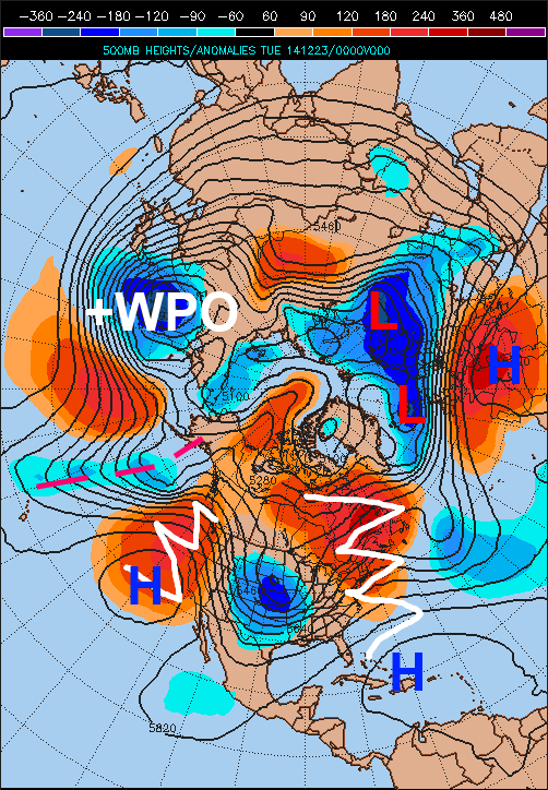
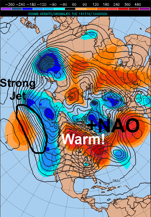
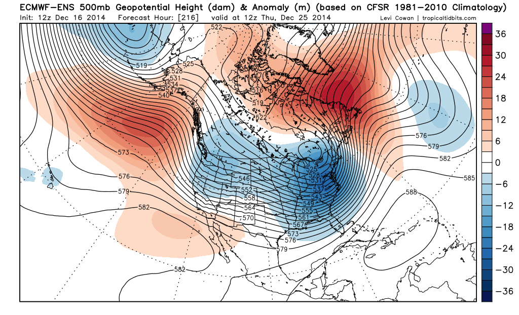
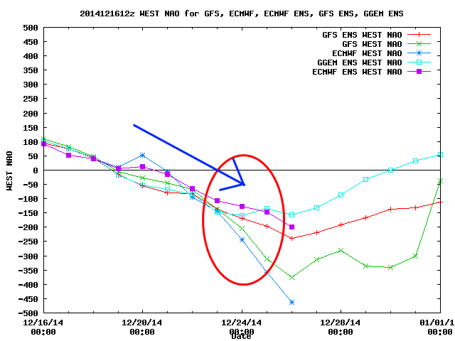
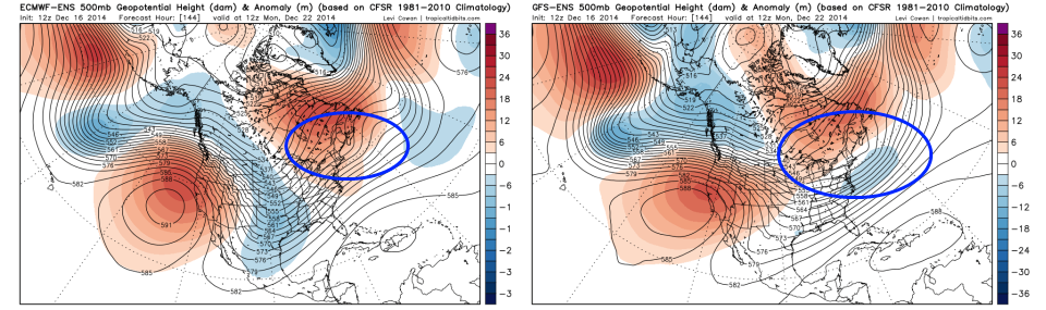
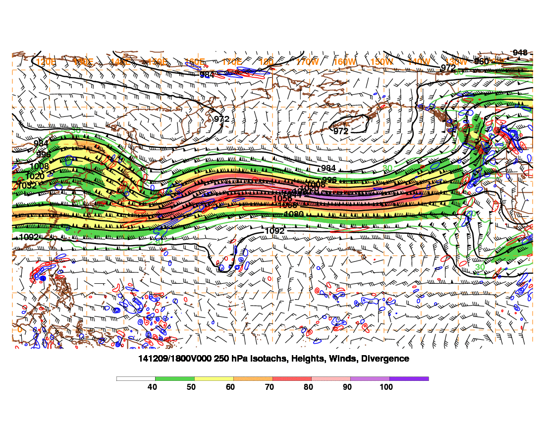
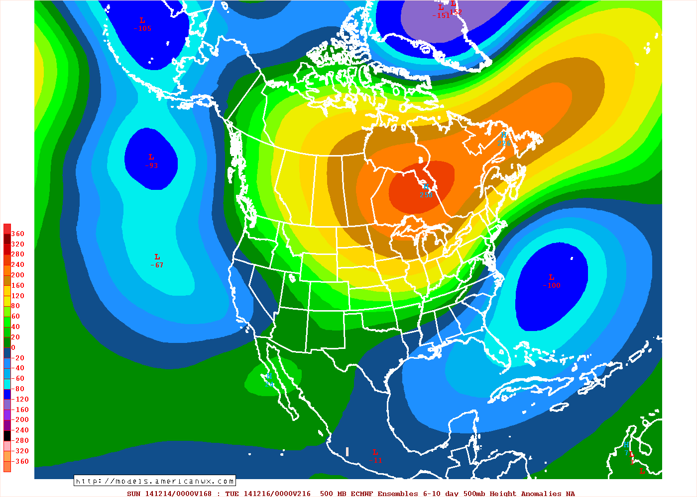
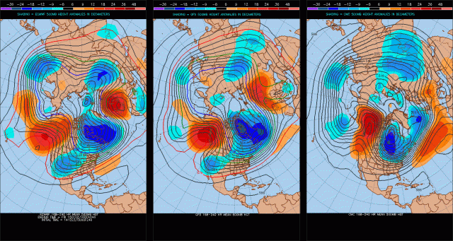
Ridging is finally developing along the West Coast as per the image above, however, the ridge isn’t very “tall” and is allowing a strong Pacific jet and shortwaves in that jet to crash into the NW US from the west. This is limiting how much cold air can build into the central and eastern US this week. This is also limiting how much cold air can build into Canada this week. In addition, the NAO still isn’t really negative. Note how there are low height anomalies over Greenland, Iceland, and really most of the far northern Atlantic Ocean, with positive height anomalies to the south. This if anything is more of a +NAO pattern, with pretty good ridging from just off the SE US coast into eastern Canada.

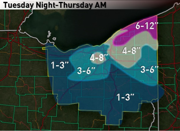
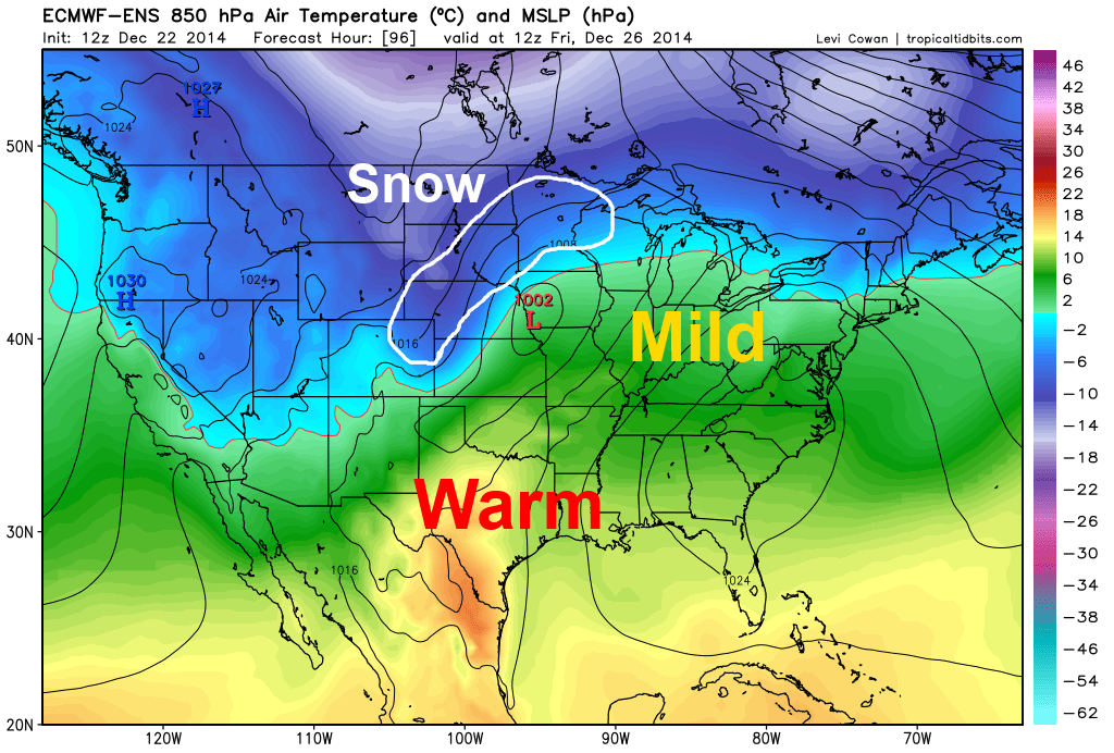
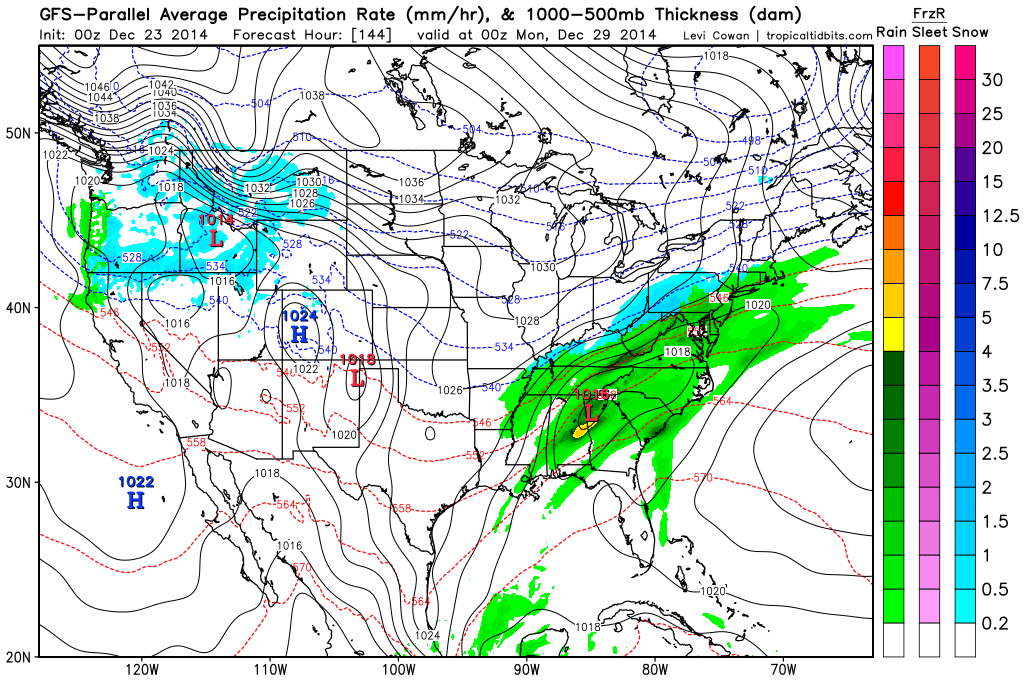
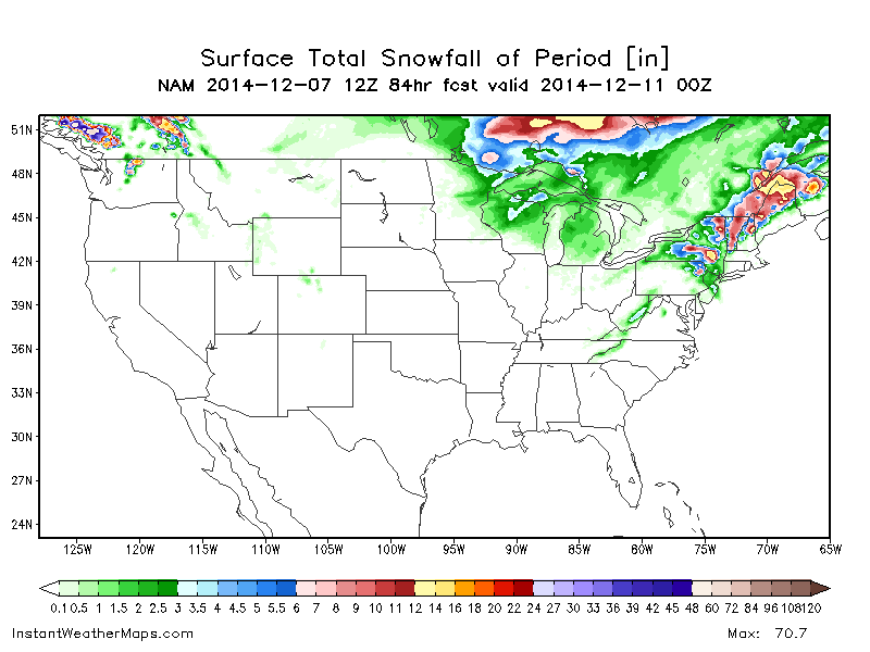
A deep trough has still developed over the central US, and a low pressure system will develop along the Gulf Coast on Tuesday and track into the western Great Lakes while becoming fairly deep. There is pretty good agreement on a low track somewhere between Chicago, IL and Sandusky, OH, which may produce a swath of accumulating snows from parts of Illinois north-northeast into parts of Wisconsin, eastern Iowa, and northwestern Michigan.

NAM 48

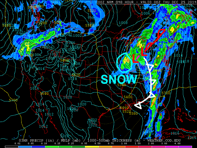
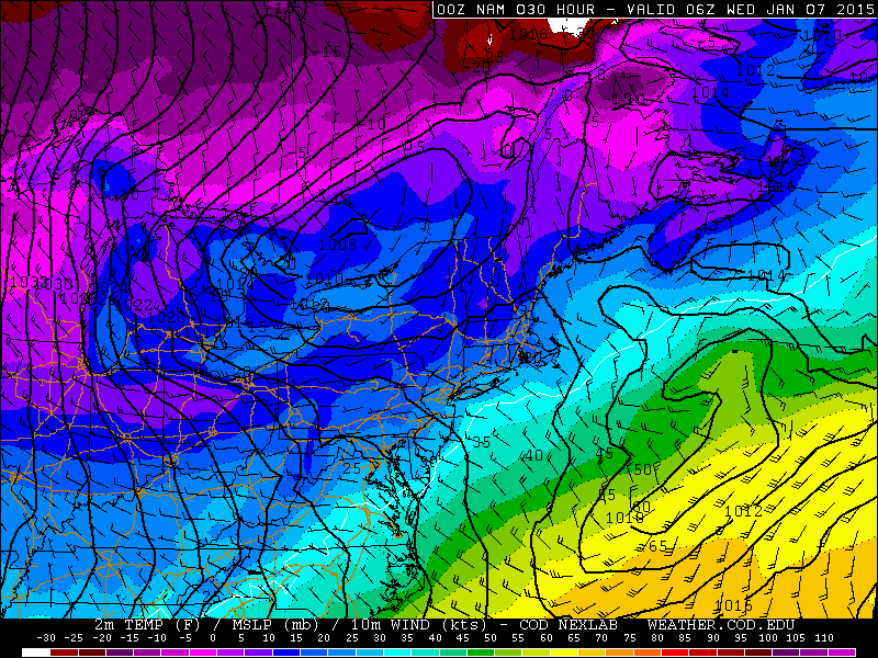
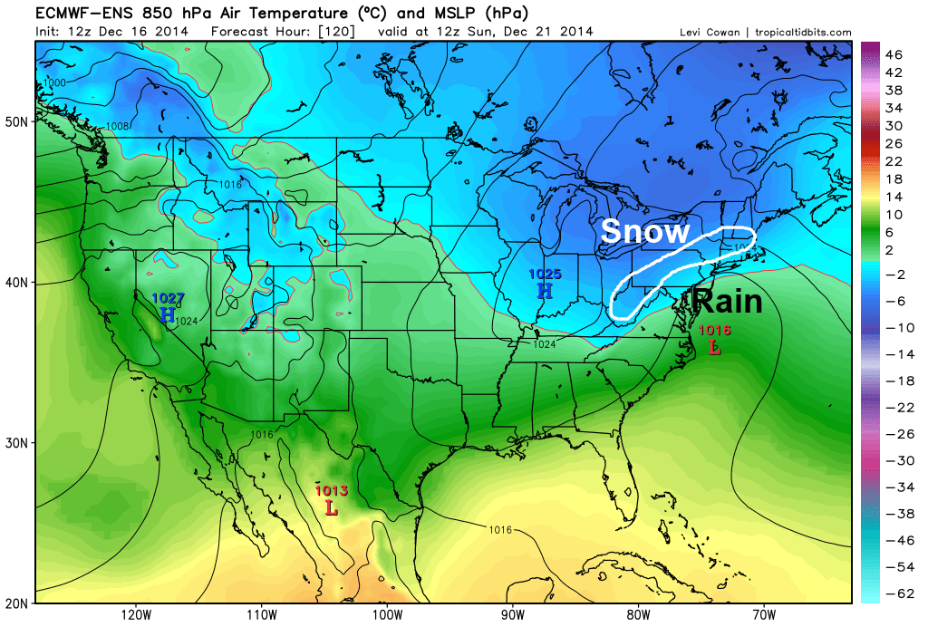
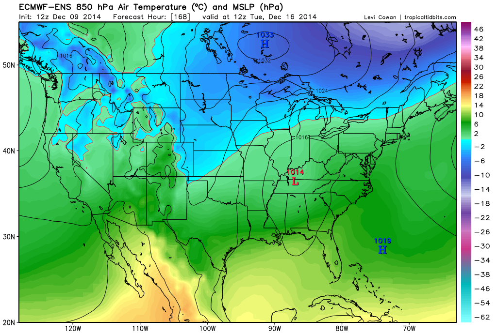
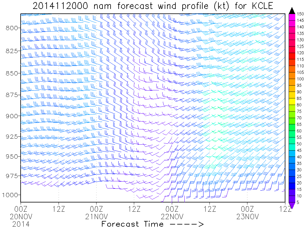
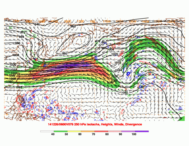
A look at the Monday evening run of the NAM model shows this scenario well. The NAM has struggled in handling this system, but finally looks pretty close to the developing model consensus. The trough being centered over the Plains in the first image of the post, combined with a SE ridge and no –NAO is what will cause the low pressure system to track north-northeast from the Gulf Coast to the central or western Great Lakes on Wednesday into Wednesday night. There looks to be a narrow but fairly intense zone of snowfall on the western side of this low pressure, which may bring several inches of snow to Chicago on Christmas Eve, which will surely impact air-travel across the region. Much of the eastern US will be unseasonably warm in the southerly flow ahead of this low pressure, and some severe weather will occur across the Deep South Tuesday into early Wednesday along the cold front trailing this storm system.

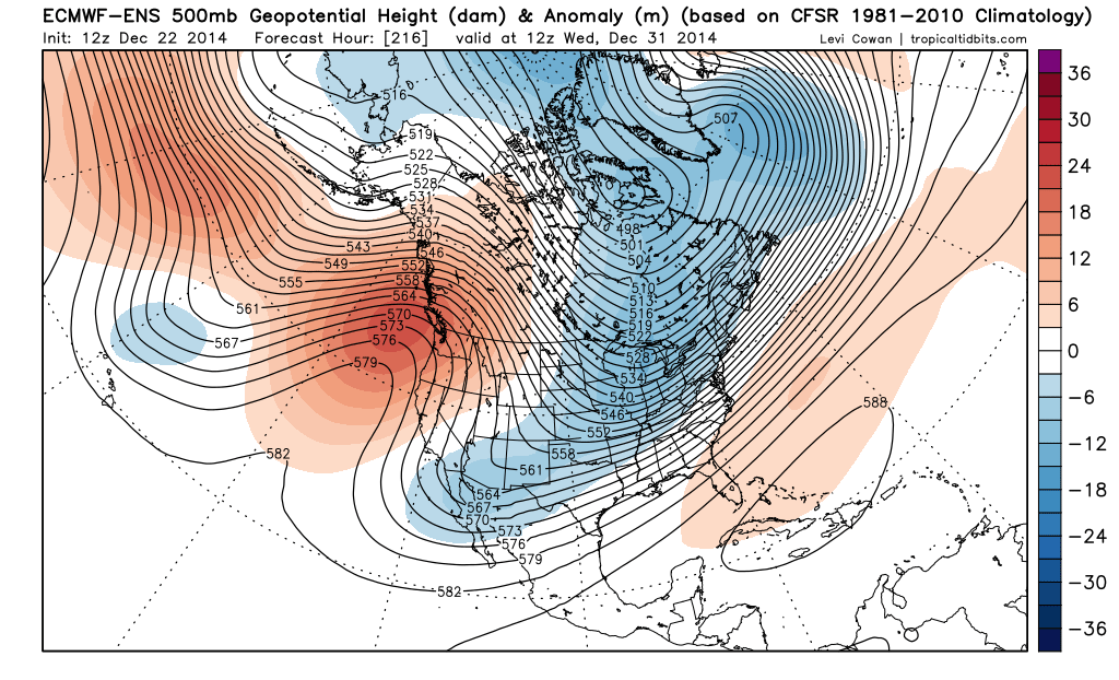
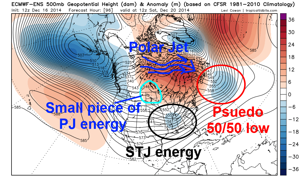
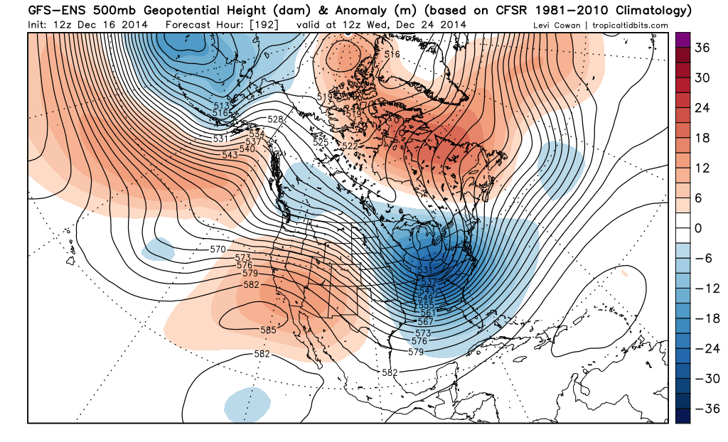
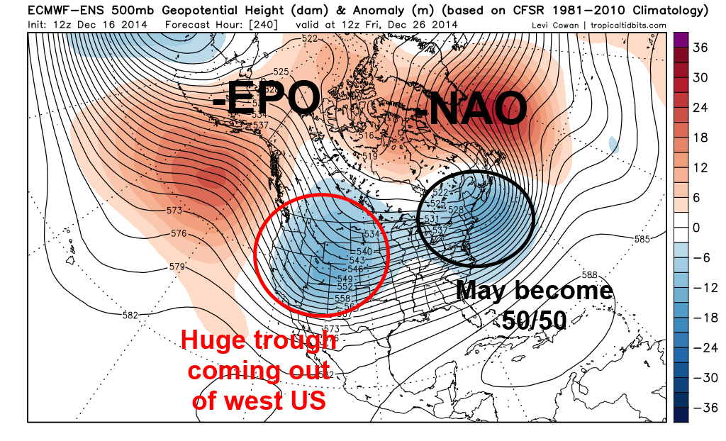
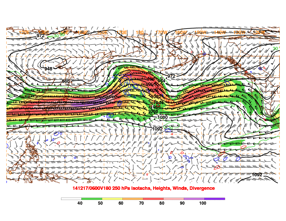
Unfortunately, the lack of true cold air over Canada and the lack of amplitude to the ridging on the West Coast, which will allow our next system (called a shortwave) to move into the NW US, will mean that the cold air pulled in behind this system will be relatively meager. In addition, as can be seen on the European Ensembles valid Friday morning, the “Christmas Eve Storm” won’t become a 50/50 low. So, while the pattern will gradually continue improving this week for cold and storminess in the central and eastern US, it still won’t be good for the eastern US heading into this weekend:

EPS 96

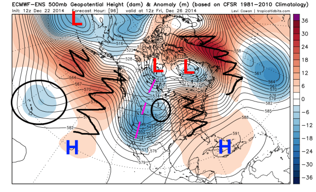
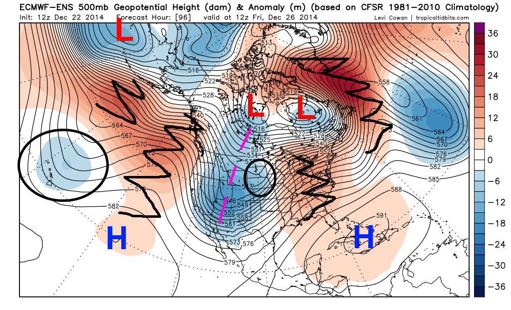
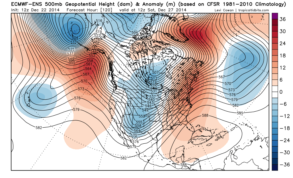
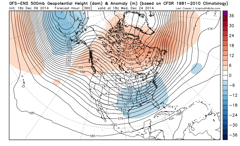
Note how by this point, the NAO is attempting to go negative, with a ridge extending towards Greenland. However, the ridge is more of a thumb ridge, and it’s still too west to really help the eastern US by this point, hence the “SE ridge” still being present on this image. The ridging over the NE Pacific and over the West Coast is getting “better,” with the jet stream forced north towards Alaska, but still isn’t sharp enough or far enough east for the eastern US. There is improved cold air over Canada however, as a bit of a PV anomaly (the low west of Hudson Bay) has dropped into the area, and as the Pacific jet isn’t blasting in as strongly.

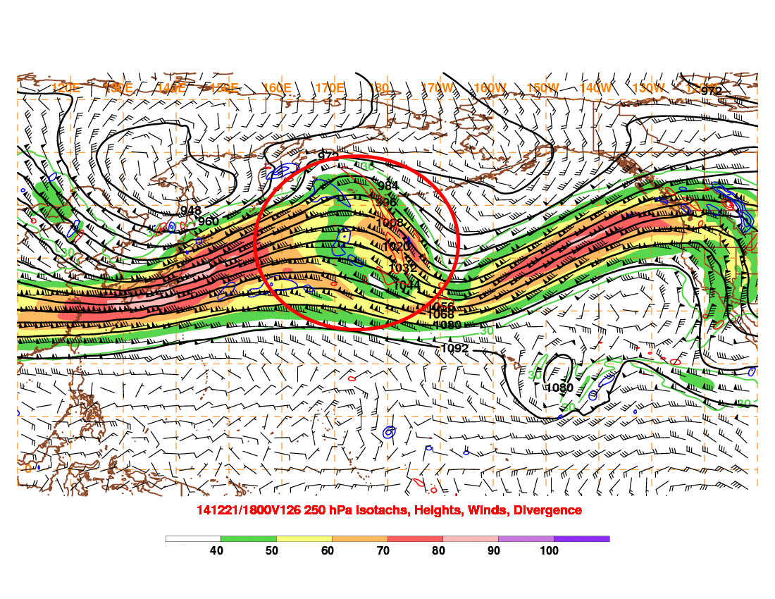
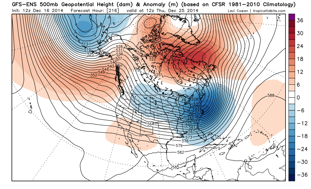
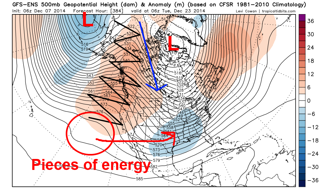
A deep trough will be swinging out of the Rockies this weekend and into early next week. With a lack of better positioning of the western US ridging, a SE ridge, and a marginal NAO, this deep trough will likely not result in significant snows for the eastern US (except for New England). However, the cold beginning to build in from Canada running into the SE ridge will setup a strengthening thermal gradient from the southern Plains east into the Ohio Valley and New England, and with energy moving out of the west (with more moving in, note the circled feature near Hawaii), this setup does seem conducive to snow/ice along the thermal gradient described above.

Threat 1: Thursday-Friday (December 25-26):

This is the featured circled on the above European Ensemble map across the Plains. This is the first piece of energy that will eject out of the western US trough along the developing thermal gradient. The SE ridge will be pretty stout, which will allow this system to track into the Midwest and northern Great Lakes:

EPS 96 sfc

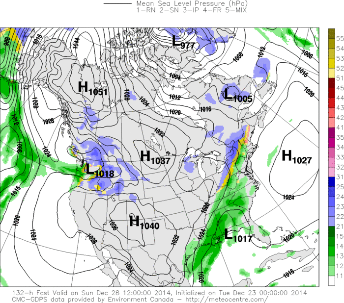
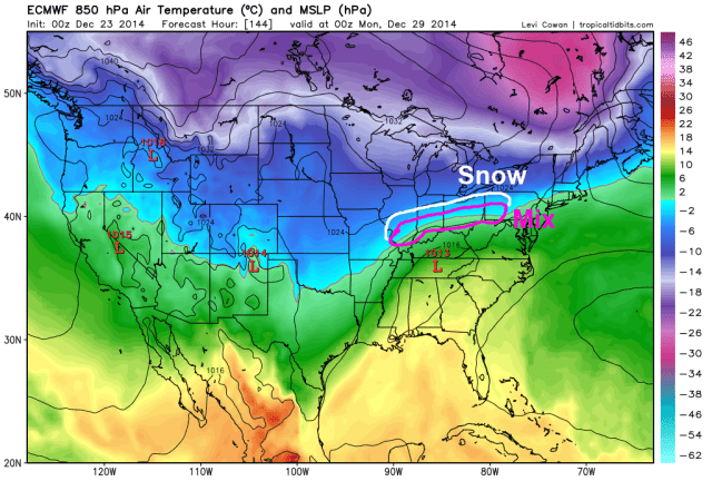
Looking at the European Ensembles at the lower levels for Friday morning, you can see a low pressure across Iowa with an area of snow across the High Plains and into the Upper Midwest, with a large SE ridge in place, with a large area of south-southwesterly winds from the southern Plains east into the lower Great Lakes, which will allow more mild air to move in to much of the eastern US ahead of this “storm.” There is decent model agreement on a potentially significant snowstorm across parts of the Rockies for Christmas Eve and Christmas Eve, with a swath of moderate snow and possibly winds across parts of the upper Plains/Midwest.

The bigger purpose this storm may server will be to help pull in a bit more cold air behind it and shift the developing thermal gradient to the south. You can see a fair amount of cold air available just north of the Canadian border, which as I discussed above looks to be in place moreso by the end of this week than right now, which bodes well going forward.

Threats 2/3 (December 27-30):

I have lumped these two “threats” into one section since our models are trying to key on two shortwaves ejecting out of the western US a day or so apart in this timeframe.

EPS 120

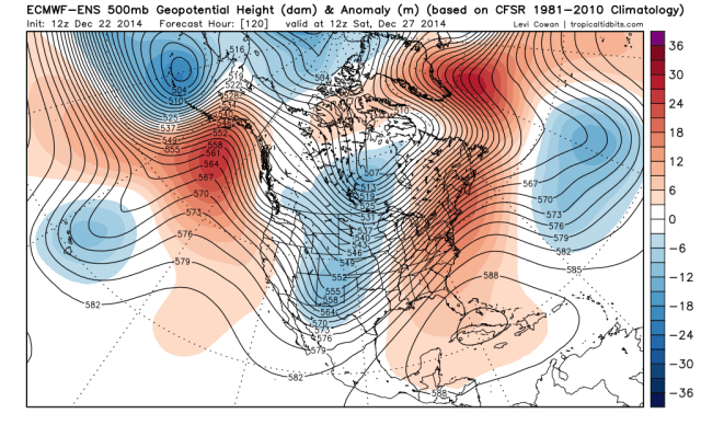
The European ensembles from Monday afternoon valid Saturday the 27th show a pattern beginning to become more conducive to snows, although most of the eastern US still isn’t “sitting pretty” yet…the NAO is modestly negative, and ridging is beginning to build into Alaska, with a piece of the polar vortex sitting over Hudson Bay. However, the mean trough is still over the Plains with a southeast ridge. This suggests that cold would continue building into Canada and the central US this weekend, with milder air still holding on across the eastern US.

There is a notable “shortwave” in the mean trough over New Mexico in the image above, getting ready to eject out into the Plains. With cold air oozing in from the north and warmth still stubborn across the SE US, there should be a decent thermal gradient across the country from the southern Plains into the Ohio Valley and northern New England this weekend, which is likely where any storm system Saturday into early Sunday would ride up along.

CMC 132

Out of this evening’s models, the Canadian is the only one that shows much of a first “wave” Saturday into Sunday. It would produce some light snow across parts of the upper Ohio Valley, southern and eastern Great Lakes and into far northern New England. I think if anything the Canadian might be a little bit too aggressive in moving in the cold for this “threat” for the first half of the weekend, meaning it might show snow a bit too far southeast.

We’ll see if any future model runs pick up on this potential wave of low pressure riding along the thermal gradient Saturday into early Sunday, as there are signs of a half decent shortwave ejecting out of the Rockies on Friday per the Euro ensembles above.

EPS 168

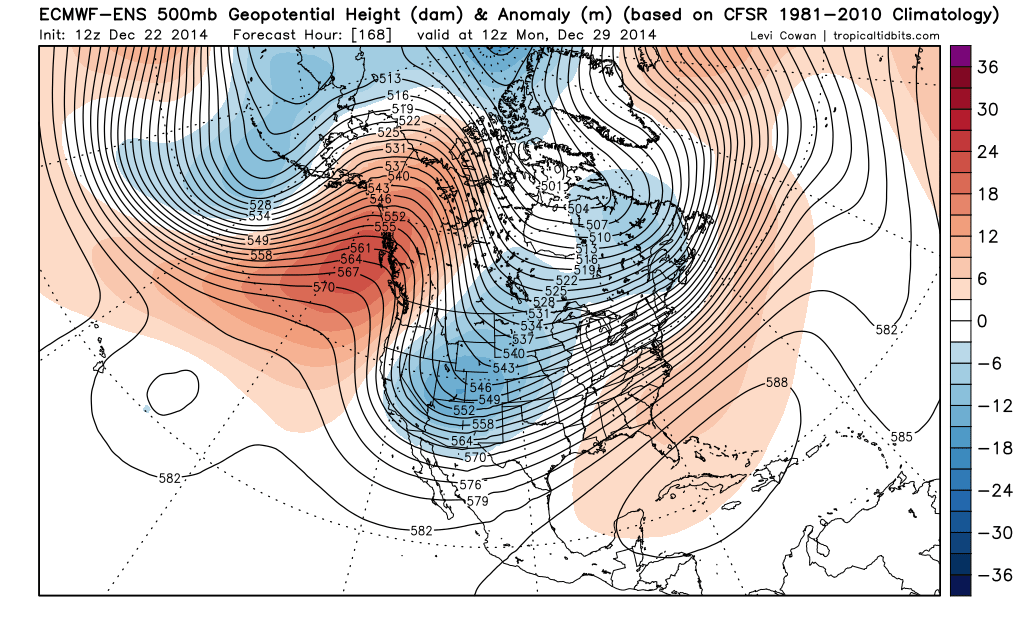
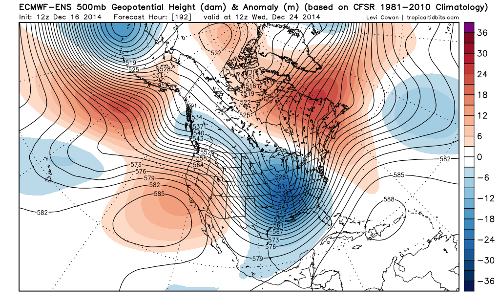
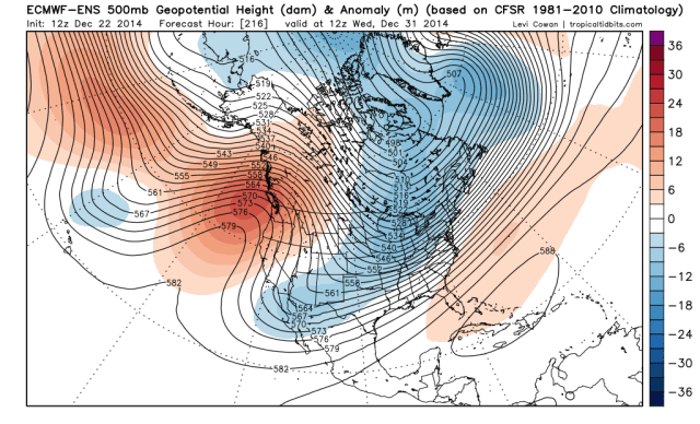
Moving the Euro ensembles ahead to next Monday morning, the pattern is starting to look better for snow farther southeast, with more energy moving out of the west. The ridging has become very amplified along the west coast and into Alaska and NW Canada, with a portion of the polar vortex still rooted near Hudson Bay. This would allow for Canada to be cold, and that cold would come into the central and northern US in this pattern. This really suppresses the southeast ridge. The NAO isn’t really negative, and this pattern has the look of fast moving storms.

The 0z Euro and GFS both liked a potential storm with this possible second shortwave ejecting out of the Rockies, with possible impacts in the central US between December 28 and 30:

Euro:

ECM 144

Parallel GFS (this will be the “operational GFS” at some point soon):

PGFS 144

When looking at the Euro ensemble images above, a few things look more favorable for this storm threat than any of the other ones this month. First off, strong west coast ridging is driving the polar branch of the jet stream well south into the US, which would possibly allow for better phasing with moisture laden sub-tropical jet shortwaves. In addition, the ensembles are trying to key on some decent confluence over SE Canada and New England, which would support a farther south storm track.

At this point, the models are all over the place with which of these two waves possibly develops, and where they track, but IF the first wave develops on Saturday, I’d favor a more northwest solution with any snow confined to a stripe from the central Plains into the lower Great Lakes and perhaps far northern New England. The second wave may be a few hundred miles farther south than that.

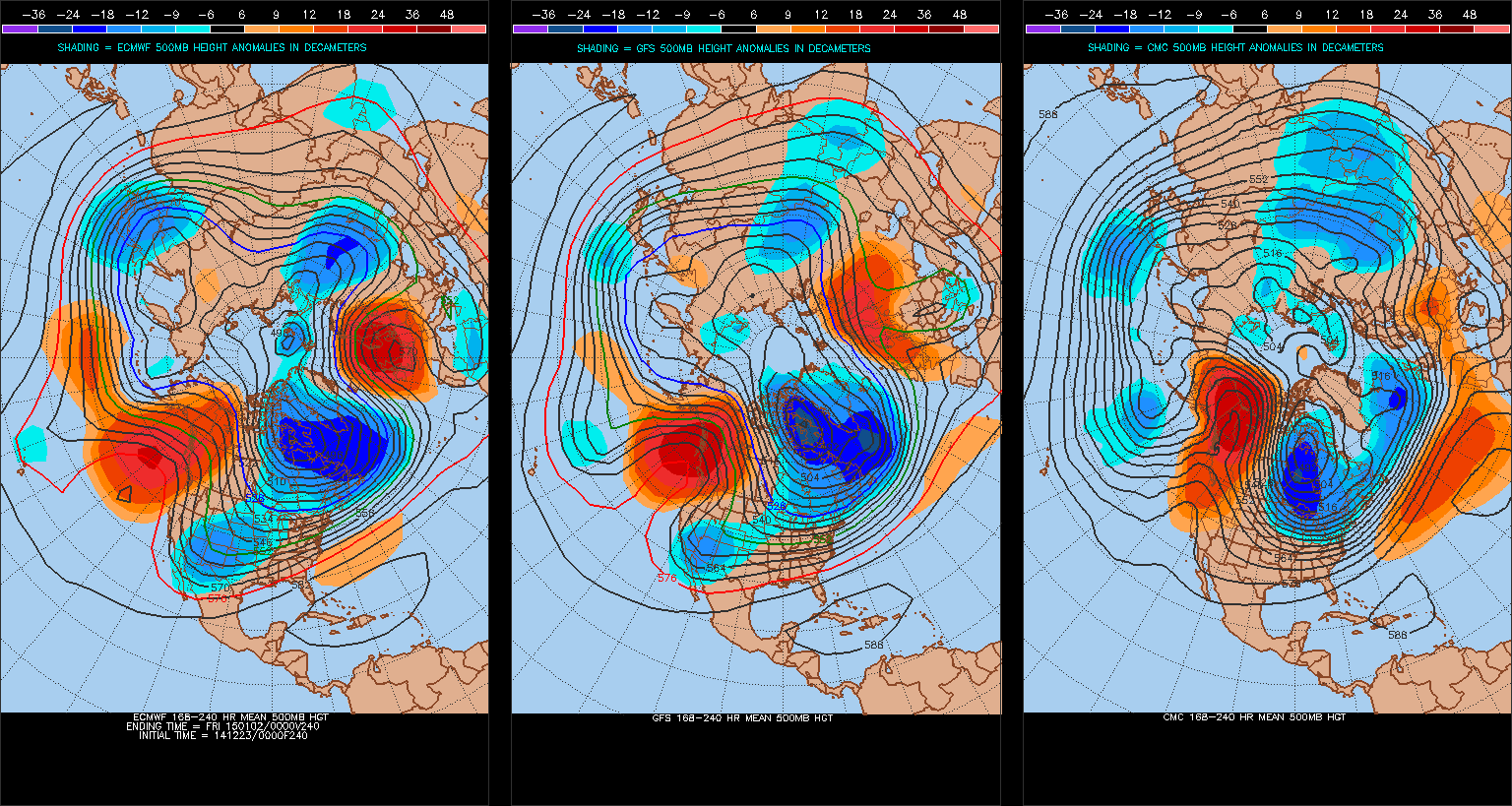
The recent trend has been for storms to end up weaker/less amplified and also warmer overall than projected by the mid-range models, and with no –NAO any storms would be fast moving. However, the western N. American ridging is much more impressive in this timeframe, which may allow for the more amplified solutions to play out with one of these two waves.

Threat 4 (December 31-January 2):

EPS 216

Some recent runs of the operations GFS, Euro and Canadian have hinted at another shortwave and associated surface low pressure riding along the thermal gradient from the southern Plains east through the Ohio Valley and Mid-Atlantic around the New Year. By this point, the western US ridging is beginning to diminish on the Euro ensembles, but the trough axis is expected by the ensembles to shift a good bit farther east. This COULD result in this wave of low pressure, if it occurs, being the farthest south. The NAO is still positive in this timeframe, so any system would be fast moving and likely positively tilted. I want to see how the next several shortwaves moving out of the west evolve and how the western US ridging looks to hold up before making any kind of concrete guess on this threat.

How cold will we get in the central US to end the year, possible warm-up to start the New Year, and moving forward:

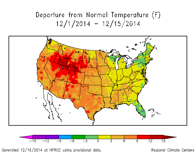
The weather pattern this month has been extremely frustrating at times…I feel as though I’ve gotten some aspects of it right, but missed some smaller details. We warmed up for the first half of the month as expected, although cold air was slow to scour out of Canada, which kept a good portion of the Great Lakes and Northeast pretty close to normal temperature wise for the first half of the month. This pattern change is occurring when it was supposed to, however the Pacific jet stream has been a bit stronger than anticipated which has made ridging over western N. America slower to develop, which makes it harder for Canada to reload with cold air and also makes it harder for deeper storms to occur, as this results in a more anemic polar-branch of the jet stream. This can be seen by storm threats around December 20th trending from a potentially large moderate swath of snow to what ending up being nothing, and by the Christmas Eve storm trending from a sub 970mb bomb over the Great Lakes to a more pedestrian 980mb-990mb storm over the region. In addition, the cold air behind the Christmas Eve storm will not be as impressive as progged a few days ago, which has ramifications for future storm threats.

8-10 models

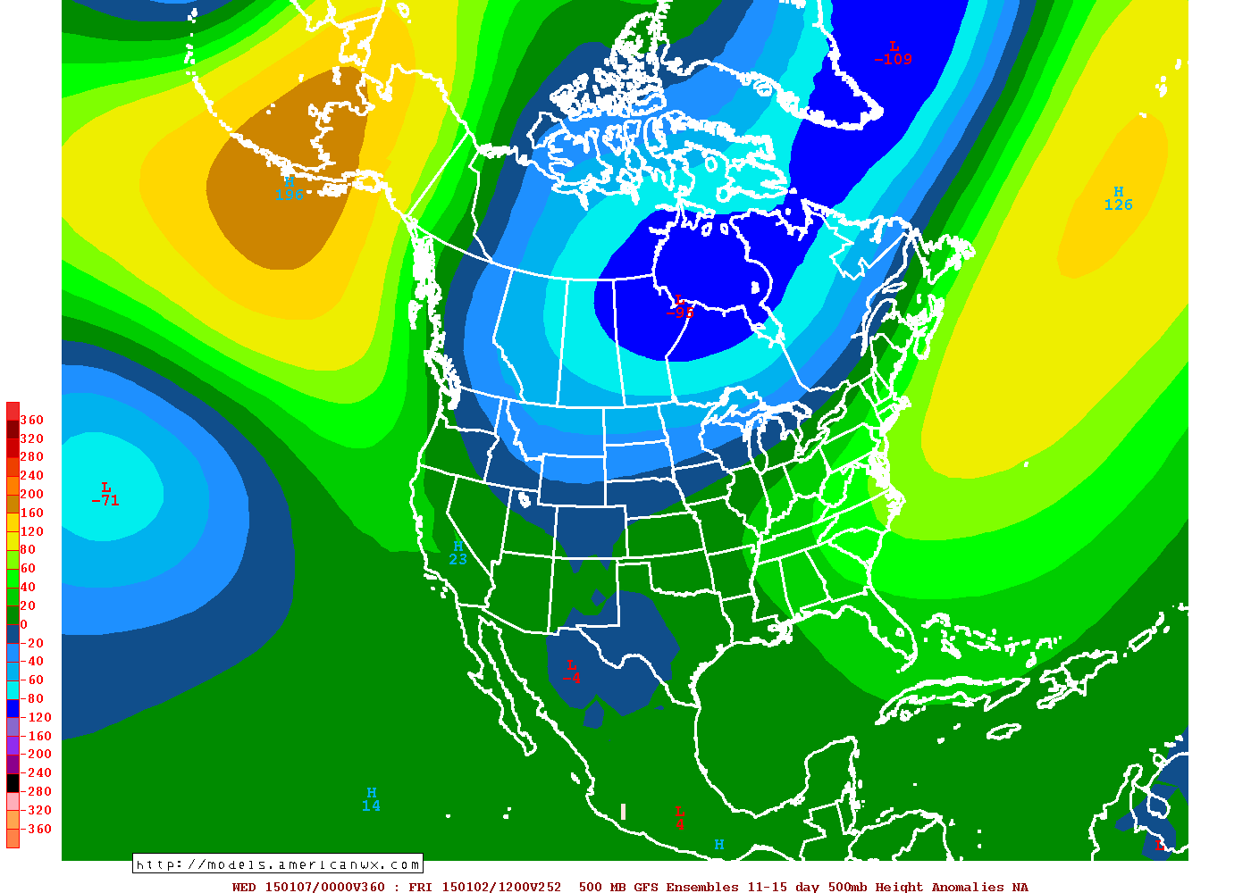
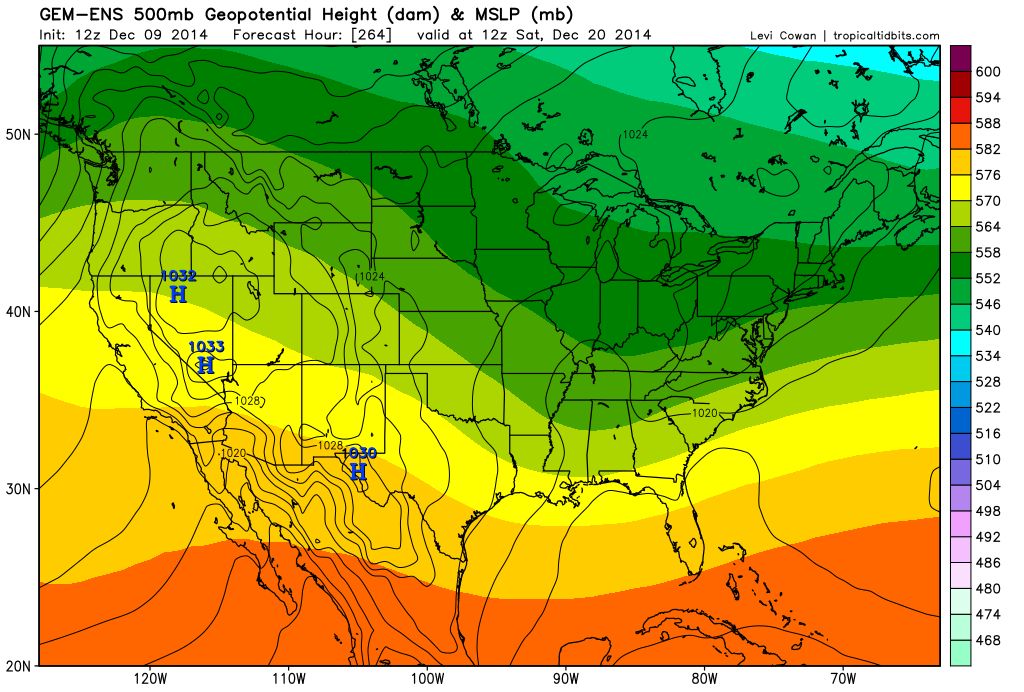
When trying to figure out how cold we may get near the New Year or perhaps just before, the models vary in how strong they get the ridging over the Alaska and NW Canada (-EPO ridge). The GFS and Euro are pretty similar and show a ridge strong enough to tap some cold air from the north-pole, with a decent chunk of the polar vortex sitting over NE Canada, with perhaps an east based –NAO. The Canadian (far right) is much more amplified with the –EPO, and farther south with the polar vortex. The Canadian would suggest a few days of very cold weather across the Midwest, Great Lakes, and New England, with below normal temperature anomalies to the Gulf Coast in the eastern 2/3rds of the country.

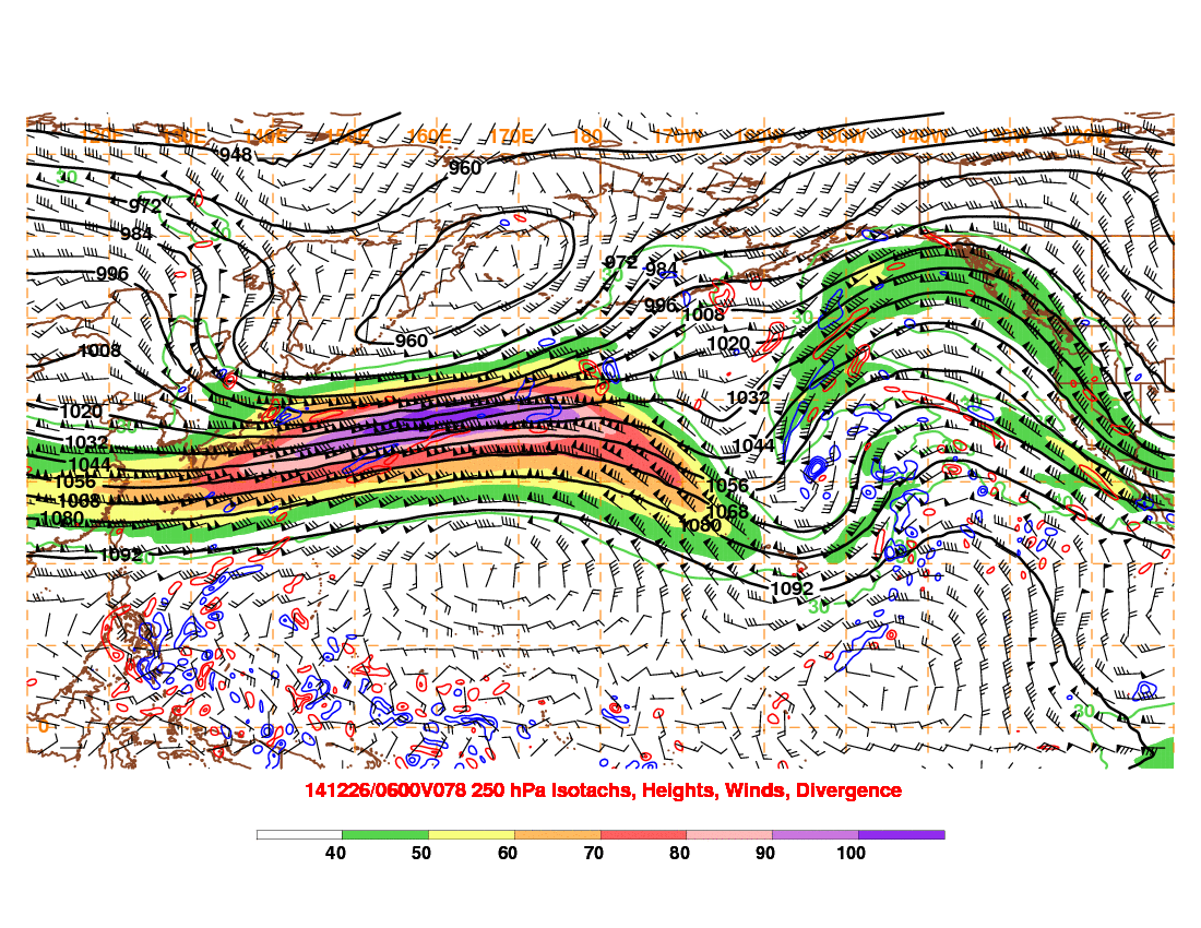
The big hindrance to this pattern change occurring in earnest and allowing cold to spill into the eastern US has been the strong Pacific jet stream. The Monday night GFS run shows a significant improvement in that regard by Friday…which isn’t too far out and should be reliable:

GFS 78

The jet is extremely strong across the western Pacific, but “break” south of the Aleutian Islands. This would suggest significant storms across the Aleutian Islands and Bearing Sea, and a big ridge of high pressure just east of there, which is shown unanimously by tonight’s model runs. Although the NAO isn’t exactly favorable, this type of pattern would possibly suggest a brief period of very cold weather in the north-central US, Great Lakes and possibly New England in the last few days of December, with gradually warmer weather farther south…AKA a gradient pattern as discussed above.

Given that the change in the Pacific jet that will trigger this will occur in the fairly short term, I have decent confidence in this bigger shot of cold air between say December 28 and January 2. It won’t be anything like the bigger shots from last year, but might actually get the lake effect snow machine going again for the first time in several weeks.

global IR

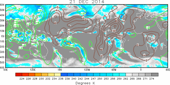
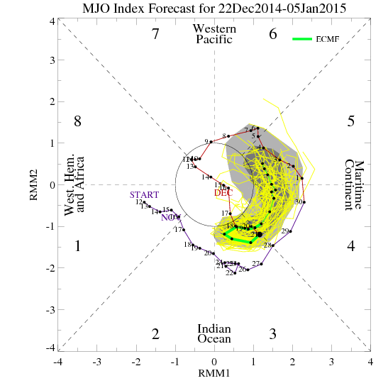
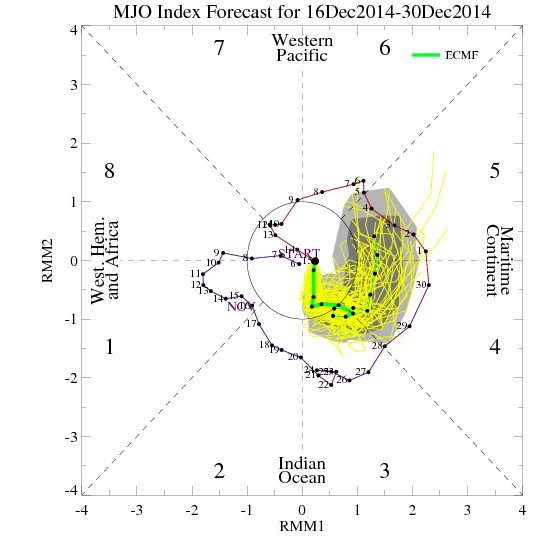
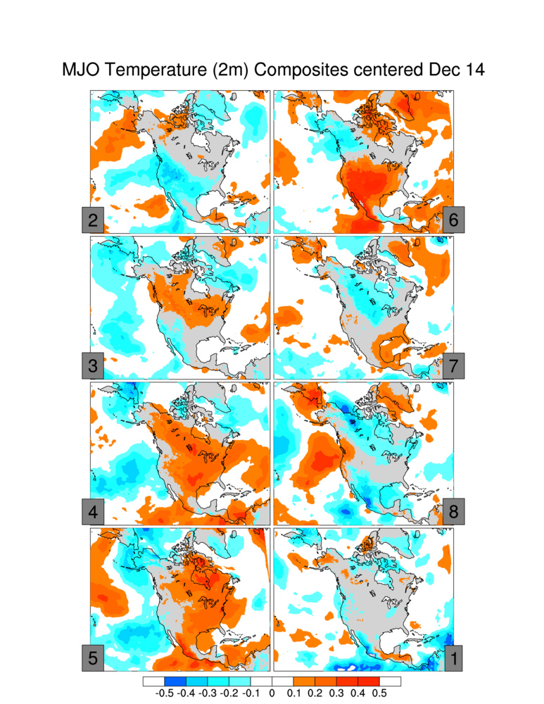
Looking at the bigger picture, I mentioned in my last post that the MJO would become unfavorable again in late December and possibly cause the cold to pull back a bit as we actually head into the first week or so of January. A look at the global satellite imagery shows very active convection across the Indian Ocean, which isn’t in a good spot for central or eastern US cold (we’d want it closer to the Dateline). Convection in the Indian Ocean typically results in the Pacific jet discussed above breaking over the NW Pacific, which puts ridging over the central Pacific and troughing along the west coast (and then ridging/warmth for the central US).

ECM MJO

The European MJO forecasts reflect the satellite imagery above, with the MJO currently in phase 3 and then working through phases 4-6 over the next couple of weeks. Phases 3-6 correlate to warmth in the central and eastern US, with phases 7-2 being near normal or cold depending on the exact phase.

GEFS telleconnections

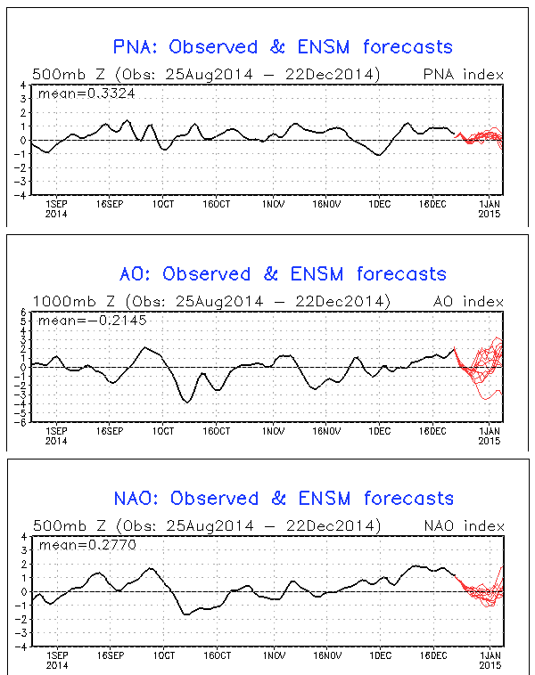
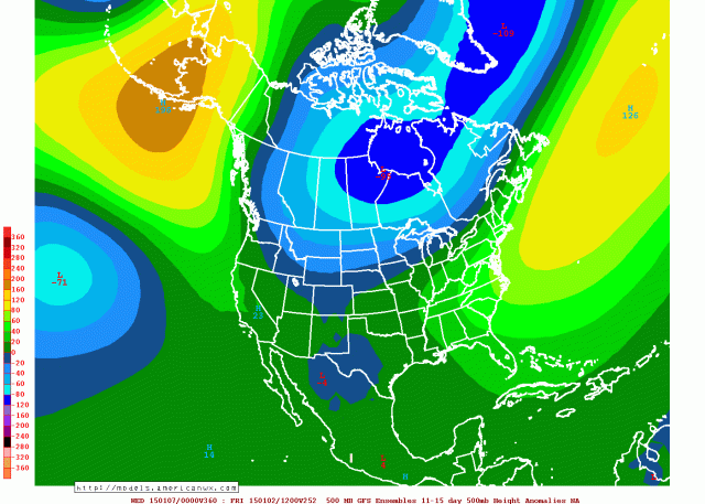
The GFS ensemble “teleconnections” also reflect a less favorable pattern heading into the New Year…with the NAO and AO rising and the PNA holding steady or falling slightly. This would also argue for a pulling back of the colder air to start January. However, the GFS ensembles do not show the Pacific pattern reflecting what a phase 3-6 MJO would suggest, as they maintain ridging over Alaska in the 11-15 day period. The Canadian and Euro ensembles also appear to resemble this to at least some extent:

GFS ENS 11-15

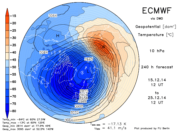
My thinking is the persistent upper low over NE Asia and the NW Pacific (+WPO), which is driving our current strong Pacific jet, is expected by the models to overwhelm the MJO signal and help keep some ridging over Alaska, which would be monumental in terms of not flooding the continent like we did earlier this month, and are still seeing the effects of in terms of weaker storms.

Summing Up:                                 

There will be a few chances for snow events over the next 10 days. I think at least one or two of them will pan out, with the favored locations being the central Plains east into the lower Great Lakes and New England, with the upper Ohio Valley and interior Mid-Atlantic possibly getting into some of the threats, especially the later ones after December 28th. The coldest air from this current pattern will likely occur in the few days leading up to the New Year, with a pull back in the cold for the first week to 10 days of January. During this time period, there may still be enough cold in Canada for some risk for wintry precipitation, especially in the Upper Midwest, Great Lakes, and New England.

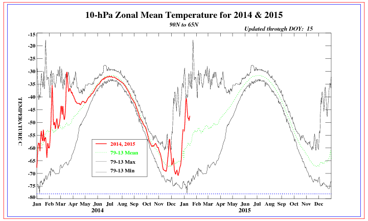
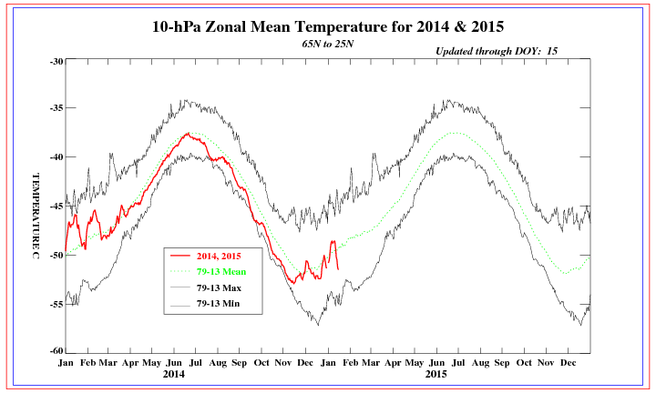
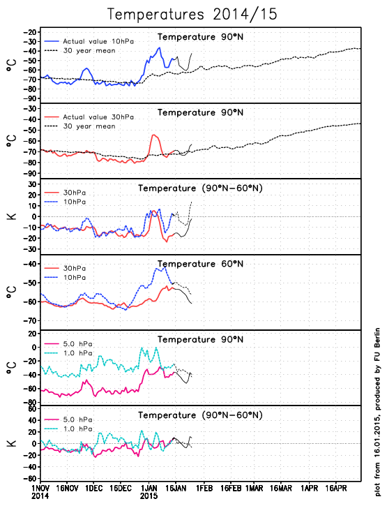
For the rest of January, as I discussed in my previous post I believe the combination of a stratospheric warming event and more favorable MJO may allow for a significant cold pattern to setup in the central and eastern US. Stratospheric warming events and subsequent –AO/-NAO blocking are very hard to predict, but this one continues to come in stronger in our mid-range models and may be legitimate. I’ll look at this more later.

Jim Sullivan

Posted in Uncategorized | Leave a comment

12/16/14: As Advertised, Active Weather Returns for Holidays

december

With the exception of parts of the Upper Great Lakes and Northeast, much of the country has “enjoyed” warmer than average temperatures to start December. This was mainly caused by a very strong Pacific jet stream overwhelming the cold air across much of the continent, outside of Alaska. This will begin to change, with 3 defined chances for storms over the next 10-14 days, and below normal temperatures likely returning to a good portion of the central and eastern US.

current 500mb

The current weather pattern across the Northern Hemisphere still isn’t a good one for cold/snow across the central and eastern US. Canada is very warm compared to normal, with a stronger than normal Pacific Jet making it hard for ridging to build across the western portions of the continent. This means that currently, we are having trouble getting truly cold air to dip into the country, and this also means that the “polar branch” of the jet stream is weak and having trough making inroads into the US. This makes it difficult to see snowstorms, and will be an issue this weekend for our first possible “storm threat” across the eastern US.

Here is a look at the Pacific jet as analyzed by this morning’s GFS model. Note how the jet is fairly strong and also oriented west-east up until hitting the west coast of the US, when it then “breaks”, which supports ridging (warmer/drier conditions) over the central/eastern US:

GFS 0

As we move the model forward to Sunday afternoon, the Pacific jet has a bit of a different look. Note how the jet breaks over the NW Pacific and “fans out”…this is known as upper level divergence, which supports storminess in the northwestern Pacific, which would favor ridging developing into Alaska next week and possibly beyond (known as a –EPO). Also note how there’s a ridge off of the US west coast (+PNA), which supports a trough developing in the central US next week:

GFS 126

This type of orientation would support true cold air returning to Canada starting next week, and would support that cold coming into the US (centered in the central US). Also, note the features south of the main jet stream over the eastern Pacific; these are disturbances in the sub-tropical jet, which bring moisture laden disturbances into the southwestern US and points east. The combination of colder air making inroads into the US with a more active polar branch of the jet stream, along with an active sub-tropical jet would support storminess next week and beyond, with someone likely seeing decent amounts of snow.

Threat 1: This Weekend:

The first potential for a snow-maker to impact parts of the central and eastern US will be this weekend as a piece of sub-tropical jet energy ejects out of the southwestern US and tries to interact with the polar branch of the jet stream over the central or eastern US:

ECM ENS 96

This isn’t a good setup for a large snow storm. The bulk of the polar jet is going around a poor man’s “omega block” (note how the pattern over the NE US and SE Canada tries to resemble the Greek letter omega), which limits how much it can interact with our piece of moisture laden sub-tropical jet energy riding across the southern US. What this system does have goes for it is a trough close to 50N, 50W that kind of acts like a 50/50 low and causes surface high pressure over the Great Lakes and New England, which does give any storm that does occur a little bit of cold air to work with. The sub-tropical jet energy is taking on a negative tilt west of the Appalachians, which suggests that any snow would be favored to occur over the Ohio Valley, Appalachians, New England and interior Mid-Atlantic. There is a small piece of energy that breaks off from the Polar Jet and moves in the central US, and if these two pieces of energy combine or “phase,” then this disturbance may produce light to moderate amounts of snow in the areas discussed above.

ECM ENS 120

The European ensembles do show a hit of a weak storm off the East Coast on Sunday morning, with temperatures cold enough for snow in the interior, with a mix or rain closer to the coast. This could turn into a few inches of snow here and there in mainly the Appalachians and interior Mid Atlantic, with the upper Ohio Valley and New England possibly seeing some snow if the “phase” discussed above occurs early enough.

Threat 2: December 24-26th:

The time period of this “threat” will surely get the weather weenies excited across the Internet over the coming days, as snow on Christmas Day is a dream come true for many of them. By this point, the pattern change discussed at the beginning of the article will be full blown, with a much more amplified trough over the central US. The main question is, will the NAO go negative and allow for any storm to possibly transfer to the East Coast and give parts of the eastern US snow for Christmas?

ECM ENS 192

The European ensemble mean valid next Wednesday morning show a beautiful trough across the central US, with the trough taking on a negative tilt over the western Great Lakes and along the Mississippi River. This is too far west for a good East Coast snowstorm, by a long shot. There is some ridging over the western US (+PNA), however there is no 50/50 low and no –NAO on the Euro ensembles. As is, the Euro ensembles would suggest the possibility of a snow storm across parts of the Plains, Midwest and Great Lakes, with a possible transfer of energy to off the New England coast with some snow in New England, as the Euro ensembles do show the very potent trough swinging east to New England by Christmas Day. The Euro ensemble solution also would suggest some potentially heavy lake effect snow in the Great Lakes Snowbelts:

ECM ENS 216

The GFS ensembles paint a slightly different picture this afternoon for the potential “Christmas Storm”…the GFS ensembles do develop a bit more of a –NAO ahead of the storm, and while they do show the trough taking on a negative tilt west of the Appalachians, they are farther east with the whole storm, which would possibly suggest good snows across the interior Northeast and Appalachians:

GEFS 192

Note how the GFS ensemble mean shows positive height anomalies (reds) over extreme eastern Canada into the Davis Straight, with a small area of low height anomalies (blues) just southeast of Newfoundland. In addition, it shows the trough taking on a negative tilt closer to the Appalachians than the Euro ensembles. The GFS ensembles show slightly weaker ridging on the West Coast, but is similar in that area in principle as the Euro ensembles. The next frame of the GFS ensemble mean would be interesting for the northern Appalachians, interior New England and possibly the eastern Great Lakes for Christmas Day:

GEFS 216

The trough has taken on an extremely negative tilt by this point with the –NAO intensifying a bit, suggesting any storm would max out and slow down over New England, with heavy snow and strong winds likely on the western side of it.

So, the debate becomes, which solution is more correct (Midwest/Great Lakes storm per the Euro ensembles vs an interior Northeast/Appalachians/eastern Great Lakes storm per the GFS ensembles)?

all models west NAO

A look at what the GFS, GFS ensembles, Euro, Euro Ensembles and Canadian ensembles do with the “west based NAO” (a –NAO centered near Iceland or the UK won’t flip this index negative, but a block near Greenland or eastern Canada will) over the next 10-14 days reveals that the GFS and Euro ensembles show a very similar decrease in the NAO over the next week, with the GFS ensembles showing just a slightly quicker building of the –NAO as pictured above. When looking at both of the ensembles side by side Monday morning, you can see where the differences start to develop:

ensembles compare

Note how the Euro ensembles on the left show this weekend’s system pulling out much quicker, and don’t leave negative height anomalies just off the East Coast like the GFS ensembles on the right show. The GFS ensembles are a little slower to dig the trough over the central US to start next week, but catch up to the Euro in that department by Tuesday. The handling in this weekend’s “storm” over the eastern US appears to influence the possible –NAO for the system next Wednesday and Thursday.

At this point I’d favor possible decent snows and winds over parts of the Midwest, Great Lakes, northern Appalachians and western New England around next Wednesday and Thursday, however, we probably won’t know with high confidence who may see the heaviest snow from the possible “Christmas Storm” until the solution for this weekend’s storm has been worked out first.

Threat 3: December 27-30th:

The active subtropical jet with cold coming into the US means storm threats will be frequent. Not every threat may pan out in the shorter term, but the possibilities will be there. The Euro ensembles show an extremely impressive map for day 10:

ECM ENS 240

This pattern would be good for a widespread and significant winter storm in the days after Christmas. A –NAO has clearly intensified and is in nearly perfect position for the East Coast, with the “Christmas Storm” moving to the northeast and likely getting ready to turn into a 50/50 low. The only rub here for the East Coast is that there isn’t really a western US ridge, it’s focused off the West Coast and into Alaska (which counts as a –EPO). Ridging in this location causes cold and troughs to be focused over the western and central US.

However, the –EPO suggests cold air will be coming into the US (with a possible cross polar flow into Canada allowing truly arctic air to possibly become involved at some point at the end of December or into early January), and the –NAO and 50/50 low combination suggests that even if storms get really strong over the Mississippi Valley/Great Lakes, that they may transfer to the East Coast. A piece of energy this strong moving out of the western US would pose a risk for widespread snow and possibly ice across the Plains, Midwest, Great Lakes and then possibly New England, the Mid-Atlantic and Appalachians if the –NAO and 50/50 low could cause any storm to eventually transfer its energy to the East Coast.

GEFS 240

The GFS ensemble mean valid at the same time shows the same –NAO and possible developing 50/50 low, but is a little farther east with the ridging on the West Coast, and showing the trough that will possibly cause the “post-Christmas storm” developing over the Midwest, as opposed to the Rockies. The GFS ensemble pattern would suggest more of a pure East Coast storm threat, as opposed to a possible Midwest/Great Lakes storm followed by a transfer to the East Coast.

Which one is ultimately correct is unknown. Both models show a similar –NAO by this point, with the differences lying in the Pacific pattern. At this point, the Euro ensembles have been pretty consistent in hinting at a Midwest/Great Lakes snow threat before a possible transfer to the East Coast in the December 27-30 timeframe while the GFS ensembles have been jumping around a bit more. It is tough to call which solution is favored, but I’ll watch trends in the coming days and post updates as I can.

Moving Forward:

ECM MJO

The MJO (which describes where thunderstorms in the tropics are located) is modeled by the European ensembles (above) to emerge into phases 3-5 for the last week of December, before possibly moving towards phases 6-7 thereafter. As you can see on the plot above, the MJO moved through similar phases at the end of November and beginning of December, which eventually resulting in our recent mild weather pattern. Here is what each MJO phase correlates to temperature wise across the continent:

MJO temps

If the MJO emerged into phases 3-5 as the Euro currently expects, this would suggest a possible warming trend for a brief time in early January. The GFS ensemble teleconnection plots also appear to show the potential for the cold to back off a little bit just after the New Year:

telleconnect

Note how some GFS ensemble members begin showing an increasing trend in the AO/NAO at the end of the run, which would suggest the pattern not being as conducive for cold over the central and eastern US. However, the PNA does remain positive, which would suggest that a “blow torch” wouldn’t be likely.

10mb 240

Another factor to watch going forward will be the potential for a stratospheric warming event with the potential for an eventual stratospheric vortex split. The Euro and GFS (Euro pictured above) both suggest a pretty significant warming event occurring in the stratosphere within the next 7-10 days, with some GFS runs even splitting the vortex within 14 days. This would potentially suggest potent –AO and –NAO blocking developing by mid-January, with cold and snowy weather likely across the central and eastern US. This warming and potential splitting of the stratospheric vortex, if it occurred, would occur in line with how other high snow cover advance Octobers played out in the following winters.

Summing it Up:

There are three distinct chances for snow makers over the next two weeks. One this weekend, which looks to be a mainly light to at worst moderate event. One around Christmas, which may favor the heaviest snows over parts of the Midwest, Great Lakes, and interior New England, with possible lake effect snows on the backside of that system. Another around December 27-30, which could be a pretty legimiate threat for a wide stretch of real-estate across the central and eastern US, depending on how exactly the pattern plays out. Things will change with the latter two threats, so stay tuned for further updates.

The coldest temperature anomalies may arrive in the central and eastern US behind the December 27-30th storm threat, with perhaps a slight warming during the first 7-10 days of January, with the potential for very cold and potentially stormy weather to return by mid-January depending on how the MJO and stratospheric warming play out over the next few weeks.

Lots to track, so stay tuned!

-Jim Sullivan

Posted in Uncategorized | Leave a comment

Snow Prospects in Ohio Valley/Great Lakes, then Pattern Change

Perhaps I’m just too optimistic, but I don’t totally hate the weather pattern shown on all three ensembles moving forward, and I think there are a couple chances to thread the needle with some snow somewhere in the Ohio/Tennessee Valleys east into parts of the Appalachians/Mid-Atlantic even before I think the pattern starts improving for cold towards Christmas and into January. Where the best snow chances end up, if any materialize, will be ironed out in the coming week or so.

The first potential system to track is next Tuesday-Wednesday. The GFS, Euro and Canadian both show a decent sub-tropical jet (STJ) shortwave ejecting into the Plains on Monday. The GFS and Canadian appear to show decent northern stream involvement and show a low tracking into the Great Lakes with a swath of accumulating snow on the northwestern end of it, with some wrap around snow showers behind it for a good chunk of the Great Lakes and upper Ohio Valley. The Euro shows almost no northern stream involvement and no snow, although some of its ensembles appear a bit more optimistic. The ensemble mean shows a low tracking across the Ohio Valley, although there appears to be a lot of spread among the ensemble members. Temps appear too warm ahead of the system, so we’d need northern stream involvement to see any notable snows. It’s not impossible though as the models appear to show a northern stream shortwave tracking across the Upper Midwest/Great Lakes in this timeframe:

ECM ENS 1

The next opportunity appears to come around the 20th. All three ensembles at 12z show another STJ shortwave ejecting into the Plains around the 19th and tracking east across the Ohio Valley thereafter. The northern stream shortwave shown to move across the Midwest/Great Lakes around the middle of next week could pull down  some cold air ahead of this next STJ shortwave, however again, northern stream involvement looks iffy for the threat around the 20th, which may limit how large of an area possibly sees snow.

The Canadian and Euro ensembles show an ok surface reflection for this far out in the ensemble means, with an inverted trough moving across the Ohio Valley the 20th-21st. The GFS ensembles show this feature staying much farther south. If the day 10+ Euro ensembles were available on a free source I’d post them instead, but the GGEM ensembles around the 20th look reasonably close to the Euro ensembles at the surface and if anything slightly less amplified at 500mb:

GGEM ens 1

The Euro ensembles if anything are slightly lower with surface pressures and show the shortwave taking on a modest negative tilt before hitting the Appalachians. The Euro ensembles show the 0C line at 850mb a bit north of the Ohio River as this system goes by, which is better than what’s shown with next week’s system, so I’d have to imagine that if there’s any northern stream involvement that this one could be somewhat interesting. There’s modest confluence over the northeast which would probably keep this one from going too far north even if there was some phasing. The GGEM ensembles do show an increase in precipitation into the lower Great Lakes as this wave goes by:

GGEM ens 2

Both ensembles appear to show a slightly better look for the East Coast, but this may become something to track across the upper Ohio Valley/lower Great Lakes. I’d say the key for this one is also some northern stream involvement and getting a little bit of cold pulled down behind next week’s system.

For what it’s worth, we can look at the Euro ensembles a day or two before this possible system to watch:

ECM ENS 2

It would probably be better if the ridge over the western US was located a little bit farther west, but that isn’t the worst look for some snow across the areas I outlined above, and that is a nice piece of energy ejecting into the Plains. There is some chance for northern stream involvement, but I’d like to see the western US ridge slightly sharper and perhaps a bit farther west to feel more confident.

After the potential system around the 20th, the pattern looks to stay active and looks to improve for those of us who’d like cold weather. The changes start in the Pacific, and you can see the change within a week on the GFS. The Euro still seems to like the MJO going through phase 7 (although at a weak amplitude) before going into the COD for most of the next two weeks:

ECM MJO

The GFS reflects a more favorable Pacific jet, probably because the most active convection isn’t well west of the Dateline and over the Indian Ocean like it had been. The GFS and it appears the Euro ensembles also appear to quiet down the convection near Hawaii a little bit in the mid-range as well, which weakens the Pac jet closer to the west coast of the US as well (which is good if we want to build a ridge there).

Anyways, here’s what the Pac jet currently looks like per the GFS:

GFS 0

At 180 hours, the strongest of the jet is focused over eastern Asia and into the western Pacific, with favorable divergence over the NW Pacific, supporting storminess near the Aleutian Islands or just west, which does support a ridge developing along the West Coast thereafter:

GFS 180

We’ll see how things evolve. The long range GFS has tried a couple of times to flirt with a very amplified western US ridge near the end of the run, but that is fantasy range stuff. Looking at the Pac jet at 180 hours is more reliable, so we’ll see if the improvement in the location of the strongest portion of it holds up on guidance over the next few days or so.

If the improvement in the Pacific is real (the ensembles have suggested it for several days, and the MJO supports it too), then we’d likely see better chances at northern stream involvement with any STJ moisture that ejects into the Plains during the last 7-10 days of the month. The ensembles do all suggest another piece of energy ejecting a couple of days before Christmas and one possibly around Christmas, but that’s pretty far out to get too specific.

GEFS 1

As to where the more active weather pattern may impact during the latter portions of the month, it may ultimately depend on how much the western US ridge amplifies. If it’s flatter, I’d say farther east would be favored, even with no real –NAO showing up for the next two weeks, as there probably wouldn’t be any opportunity to phase over the Plains like we’d need. If it’s sharper, we’d probably see northern stream shortwaves dive into the Plains, and with no –NAO, if they have some STJ energy to phase with (which looks quite possible), then they may cut farther NW, which would be good for a lot of this sub-forum. So, I do think we may have some chances late in the month.

As for heading into January, we’ll see. Some of the longer range MJO plots try to suggest the MJO might become a bit more unfavorable, however for now it doesn’t look to be quite the amplitude it was over the last couple of weeks. In addition, the GFS and Euro have both been hinting at some good warming in the lower portions of the stratosphere (100-50mb) during the latter third of December for a few runs now, with some signs of the vortex becoming disturbed. If that persists, that could correlate to a more –AO heading into January. If western N. America ridging does in fact develop over the last third of the month like the ensembles are currently insisting on, this could allow for a much colder weather pattern to develop at some point between January 1 and 10. We’ll see:

ECM strat

Anyways, a lot of this is speculative, as a lot of long range stuff is. But, with an active STJ, I think we’ll have our chances during the last third of the month, with the more optimal chances probably coming closer to the last week of the month as we get more northern stream involvement. It may come down to when individual shortwaves phase to determine where the best threat for snow ends up (IE here or closer to the East Coast), and that’s obviously a crap shoot this far out. Early indications look like a pretty cold start to January, but we’ll have to watch how the Pacific pattern and possible stratospheric warming play out over the next couple of weeks.

Posted in Uncategorized | Leave a comment

12/7/14: LONG RANGE: Cold, Snow to Return for Holidays?

After a very cold second half of November across a large portion of the central and eastern US, December has come in a bit milder (although still near to below average, especially across the northern tier). A slow moving low pressure system off the East Coast Tuesday-Wednesday will produce heavy rain, damaging winds and coastal flooding to the I-95 cities from Richmond to Boston, with heavy, wet snow well inland. Higher elevations may see significant snow accumulations from this storm, mainly from Pennsylvania points northeast into parts of Upstate New York and New England:

NAM 84

After this storm system clears out for the weekend, an unfavorable weather pattern for cold/snow across much of the US outside of the mountains along the west coast will take hold, due to a deep Gulf of Alaska low flooding the country with Pacific air:

ECM ENS 6-10

Note the expansive area of above average height anomalies across Canada on last night’s European ensembles in the day 6-10 timeframe, which suggests that arctic air will be locked up well north of the Canadian border around mid-month. Also note the generally low height anomalies from the southwest US east across the Gulf Coast states and off the East Coast, which does suggest an active sub-tropical jet. This means that the pattern won’t be dry across the southern US, but there won’t be much cold air to work with, meaning little snow after this week’s storm across the northeast.

BUT, times are a changing after mid-month, courtesy of the “MJO.” The MJO involves thunderstorms across the deep tropics. The location of these thunderstorms impacts where the jet stream is stronger, which strongly influences where troughs/ridges and hence colder/warmer air are more likely across the entire northern hemisphere. Recently, the MJO has been moving through phases 3, 4 and 5, and has recently moved into phase 6. The MJO has been expected to move into phase 7 after mid-month for a while now, and is still expected to do so:

MJO forecast

As I labelled on the plot above, the MJO has been in the warm phases since late November, explaining the recent relaxation of the cold air. However, phase 7 is cooler and phase 8 is almost always cold in the central and eastern US. Note how this plot of temperature anomalies with each MJO phase for early December matches the recent pattern evolution fairly well, with temperatures gradually warming as the MJO goes through phases 4-5 and becoming the warmest in phase 6, which our models show happening late this week into next weekend:

MJO phases

The weather the past week hasn’t been particularly warm due to the cold air in Canada being slow to scour out, however the overall pattern evolution has matched pretty well (note the cooler weather near the West Coast, which correlates to the recent increase in storminess there). Also note how MJO phases 7-8 correlate to colder air building back into the central US and trickling into the eastern US. This suggest cooler air returning to the east at some point after mid-December.

The MJO stuff is all fine and dandy, however recent runs of our forecast models are also trending the way of a cooler weather pattern returning after mid-month:

GFS ensembles:

GEFS

GGEM ensembles:

GGEM ENS

And, although I can’t post the Euro ensembles because they’re behind a paywall, the Euro ensembles also show a similar pattern two weeks out.

This pattern would be highly interesting from the Plains east through the Ohio/Tennessee Valleys, eastern Great Lakes and into New England and the northern Mid Atlantic. The Gulf of Alaska low that will develop this week as discussed above is shown to “retrograde” to the west towards the Bearing Sea/Aleutian Islands, which pumps up a +PNA and –EPO ridge over western North America. This allows either a flow from the Arctic Circle or per the GGEM and Euro ensembles a “cross polar” flow to develop, which allows cold air to return to Canada during the third week of December, after it gets blasted away next week. Although the NAO is either neutral or positive, the ridging over the western coast of the continent allows this cold air to begin getting into the central US by around the 20th per current modelling. In addition, there are hints of the active sub-tropical jet stream discussed above continuing through the rest of the month, which may mean an active storm track continuing across the south-central and then eastern US through the remainder of the month, with cold air coming into play by the last week of the month.

So, with all this said, what do I think will happen with the weather pattern?

-For this week, temperatures will warm to above average across much of the central US, with near to below average temps across the east with snow in the interior Mid Atlantic and New England. The west will be near average in the temp department overall with increased precipitation (rain/mountain snow).

-For December 15-22, temperatures will be near to above average across the central and eastern US, and warm to above average along the west coast as the +PNA begins to build. The northern portions of the US may begin to see cooler air return in this timeframe per the MJO progression and current model ensemble guidance, however, Canada will take some time to cool back off once the +PNA/-EPO begins to develop and models have been known to rush pattern shifts before, so I’m going to stick with average to above average temps still in the central US for this week.

-For the end of December into the New Year, if this pattern change occurs as I believe it will, temperatures will likely be below average in the central US into the Great Lakes and New England. With no –NAO and cold appearing to dive into the central US, a southeastern ridge may persist, which would keep the lower Mid Atlantic and Southeast warmer. This pattern may favor snows from the Plains east through the Ohio/Tennessee Valleys, southern and eastern Great Lakes, New England, and the interior and northern Mid Atlantic.

This pattern change isn’t a certainty, however the MJO has been modelled to progress through unfavorable phases and cause a warmer start to December and then become more favorable after mid-month for a while now, and that looks to happen as the thunderstorms in the Indian Ocean have propagated east into the western Pacific recently. The models are picking up on this as the ensembles have been showing a corresponding pattern change by late in the month for several runs now. We’ll see if the change occurs before Christmas like the models show or is closer to New Year’s…either way, the potential for colder and snowier weather to return to parts of the central and northeast US around the holidays appears to definitely be on the table.

Posted in Uncategorized | Leave a comment

11/20/14: Lake Effect Snow Late Today-Friday Morning in NE Ohio

Map:

snow 11-20 no NEO

Brief Summary:

A southwesterly wind flow this morning will focus a band of very heavy lake effect snow on western NY south of Buffalo. This afternoon, a surface “trough” will begin pushing south across Lake Erie, with winds becoming more WNW behind the trough. This will allow the band of heavy snow to swing southwest across the Northeastern Ohio Snowbelt. Extreme lake-induced instability, equilibrium levels above 10,000 feet and good moisture suggest that this band will contain 1-2” per hour snow rates as it goes, and drop a quick 2-4” of snow on most of the Snowbelt, with locally more in northern Ashtabula County where it may be more persistent. Behind this trough, a WNW wind flow suggests at least snow showers continuing across northern Lorain, Cuyahoga, northern Summit, Lake, Geauga, northern Portage, Ashtabula and Trumbull Counties through Thursday night. Lake effect conditions will gradually become less favorable starting Friday morning, and the winds will take on a more southerly component during the afternoon, likely ending the event by evening. Given a quick 2-4” snow band swinging across the area from Cuyahoga County points east, and additional snow showers behind it, accumulations of 3-6” are likely from eastern Cuyahoga points east, with locally more in northern Geauga/northern Ashtabula Counties. It is possible a more organized band tries to develop along the central lakeshore Thursday night behind the trough given a lake aggregate trough persisting downwind of Lake MI and surface ridging nosing in from the SW trying to maintain convergence near the central lakeshore through the night. If this occurs, parts of Cuyahoga/southern Geauga may see heavier snow totals than I have here…however, I’m not confident enough in this occurring to go “all out…”but I’ll watch for it.

Detailed Discussion:

An upper level shortwave will move across the eastern Great Lakes this evening. At the surface, the models all agree on a surface trough moving across Lake Erie late this afternoon into this evening as the shortwave goes by. This is a common scenario. Winds will be WSW ahead of the trough, keeping any heavy snow confined to northern Ashtabula County points NE through most of the afternoon, before expanding SW by evening. Behind the surface trough, winds will go WNW, which favors Cuyahoga County points east for better snows. Winds gradually go W Friday morning and more SW by Friday evening, gradually pushing the snow north on Friday. Instability will become extreme Thursday afternoon and evening, and then become more moderate through most of Friday morning. Instability then really falls off Friday afternoon. Equilibrium levels will range from 10-13k feet Thursday afternoon into early Friday, and then begin gradually dropping Friday morning. Moisture looks good Thursday afternoon and evening, with deep moisture to near 9-10k feet. Moisture remains favorable to around 850mb through Friday morning before drying out Friday afternoon.

As is always the case, band development, location/movement and intensity are all key. We already have our band, and it’s burying western New York. Bands tend to develop southwestward towards Cleveland as a surface trough begins moving across the lake. Most hi-res models show this Thursday afternoon, and we’ve seen it play out before many times. This may allow heavy snows into northern Ashtabula Thursday afternoon. Elsewhere, we’ll probably have to wait until the trough approaches the lakeshore Thursday evening to see better snows develop. When the winds take on a northerly component behind a trough, a good band along the trough usually occurs as far west as northern Lorain County (and obviously across Cuyahoga County). Although I think the trough will go through too fast for the band to maintain in any one spot for more than a couple of hours Thursday evening, the strong convergence along the trough along with the very good instability/decent moisture discussed above suggest 1-2” per hour snow rates with any band moving through as the surface trough tries pushing inland. This suggests at least a quick 2-4” for Cuyahoga points east with the surface trough passage. The 0z NAM shows a period of -20 ub/sec omegas in the snow growth zone at CLE as the surface trough goes by Thursday evening, which is a strong signal for intense snow rates of easily an inch per hour.

Behind the trough, the question becomes, as it often does, how quickly does the band push inland, does it weaken, does it re-organize, etc…? The NAM and HRW’s, to go along with a couple of the 0z BUF WRF’s show a more WNW flow behind the trough. The GFS shows a more NW flow. Given a lake aggregate trough likely persisting downwind of Lake Michigan Thursday night, and surface ridging building in from the southwest towards Friday morning, I’m inclined to believe the NAM’s winds more than the GFS. BUFKIT shows well aligned WNW winds on the 0z NAM behind the trough, which suggests lake effect may try to re-organize behind the passage of the trough across northeastern Lorain/Cuyahoga/Geauga Counties. The hi-res models are iffy on this, the ARW shows this occurring and shows 0.5-0.75” of QPF across a good portion of Cuyahoga County, while some of the 0z BUF WRF’s hint at it but don’t show as much QPF. This will need to be watched, as lake effect conditions suggest rates of up to 1” per hour could persist in any organized banding into Friday morning, before gradually dwindling and shifting northeast as surface ridging really builds in. Winds will be a bit stronger behind this trough than last week’s event, which may try to limit organization of snow behind the trough.

For amounts…went with a quick 1-3” in western Cuyahoga/northern Lorain as the trough swings by…a quick 2-4” from eastern Cuyahoga east…and a bit more in northern Ashtabula where the band may start affecting sooner. After that, went with additional light accums in northern Lorain/western Cuyahoga Thursday night into early Friday, and an additional 1-3” from eastern Cuyahoga east due to uncertainty over if renewed banding can form for several hours later Thursday night into early Friday. Another issue to consider is that 850mb temps of -16 to -18C are perfect for high snow ratios in a lake effect scenario, which may help areas not along the immediate lakeshore accumulate snow pretty well. In general, I actually feel like I’m being conservative on amounts here, mainly due to the short duration and small margin for error.

“Fun images”:

NAM Omega (red contours)/RH (fill)/snow growth (purple/yellow lines):

RH

NAM wind profile:

NAM wind

A BUFKIT “graph”…yellow line is the equilibrium level (45F water temp used)…scale is on the right…white line is lake-induced CAPE (scale is on the far left)…lines are winds between 910mb and 850mb (in degrees, scale is on the left):

BUFKIT graph

Posted in Uncategorized | Leave a comment

11/16/14: Brief Ohio Update

I haven’t had time to write much the last several days due to school. Snow is coming to Ohio tonight into Monday. Here is a map I made for Neoweather.com this morning for statewide accums:

precipitation

A big lake effect snow storm is expected off of all of the Great Lakes for the first half of the work-week. A very deep upper level low is expected to close off near James Bay by Tuesday, which is a classic pattern for some of the heaviest lake effect snow events seen off of the Great Lakes. Unfortunately for NE Ohio, this suggests a southwesterly wind off of Lake Erie. This is a big signal for significant lake effect snow from Buffalo proper points south along the Chautauqua Ridge in southwestern NY State, but most of NE Ohio will be spared, despite the lake effect snow watch for the most northeastern corner of the state. Here are my thoughts:

LES 11-18 prelim

I am somewhat interested in the Tuesday evening timeframe for those plowable amounts to get into extreme NE Ohio. A surface trough is shown to go by and bring the winds around to a more westerly direction for a very short (like 6 hours) window Tuesday evening, which could push intense lake effect into Lake/Ashtabula/northern Geauga Counties for a time:

GFS 54

My general thinking is with extreme lake induced instability in this timeframe with very high inversion levels and good deep moisture is that even if we do only have a 6 hour window of good lake effect in the NE corner of the state that over half of a foot could fall in a small area in a short time frame. I don’t feel like there’s a lot of confidence here due to strong surface high pressure building in from the southwest trying to keep the winds off shore. The NAM, which did a better job with the wind direction for the lake effect event last week, doesn’t show the winds coming around towards the west quite as much as the GFS:

NAM 54

So, we’ll see if lake effect can clip the extreme northeastern corner of the state for a time Tuesday evening. I wouldn’t hold my breath for heavy amounts outside of the Ashtabula to Conneaut corridor, and even there it’s iffy in my opinion.

Later in the week, another re-enforcing shot of cold air will move into the Great Lakes and set off more lake effect snow. Parameters for this event look ok but not great like this upcoming early week event. However, the models are trying to show a more WNW wind, so even if this event is less intense, it looks to stand a better chance at possibly bringing plowable amounts to the Cleveland area points east:

BUFKIT

As a note, Lake Erie will cool several degrees this week due to nearly record cold air for mid-November. This will limit the instability future lake effect events have to work with to an extent, although until the lake freezes significant lake effect can and probably will still occur.

Last Week’s Lake Effect Reflection:

Lake effect snow season started with a bang across northeastern Ohio on Thursday and Friday. A mega band with 2” per hour snow rates and thunder/lightning at time dropped over a foot on portions of Lake County on Thursday, with fairly well organized lake effect continuing from northern Lorain and Cuyahoga County points east Thursday night through Friday night. Based on spotter reports and some guessing to fill in the gaps, here’s an approximation of how much snow fell from the event:

snow 11-13 to 14 final map

Here was my forecast going into the event:

snow 11-13 no cities

Whoops! That’s not good. This was probably one of my biggest lake effect snow busts ever. So, what went wrong? In my posts leading up to the event, I discussed how a surface trough moving through Thursday afternoon may enhance a good band across Lake/northern Geauga/Ashtabula Thursday morning into the afternoon. That certainly happened. I also mentioned a possible re-organization Thursday as surface pressures began to rise. That also happened. I also discussed generally favorable parameters for moderate to heavy snow Thursday morning into Friday evening. And oh, that happened. So, why did I forecast such low amounts?

I’m not sure, and I’m kicking myself. I had a lot of the right ideas, but totally blew the amounts. I’m not going to with the argument that I’ve read before of “I nailed the pattern but missed the anomalies” or some crap like that. If my forecast was wrong it was wrong. Lake effect is tricky and you will have a lot of forecasts that are off somewhere, somehow, but this was one of my worst busts ever. I feel like the big concern was I didn’t try to forecast amounts as much as I tried to worry about coming off as “too aggressive.” And that’s pretty aggravating to me. It basically comes down to if you expect good banding when lake effect parameters are generally favorable, especially multiple times over a multiple day event, don’t be shy on amounts. And also, don’t worry about what others think of your forecast…they’ll get there’s when you’re right 😉

The pattern looks less wintry for a week or so starting this weekend. I’ll post if anything fun comes up, and possibly on the lake effect this week if it warrants for northern Ohio.

-Jim

Posted in Uncategorized | Leave a comment